

Models showing storm soon in Atlantic?
Moderator: S2k Moderators
Forum rules

The posts in this forum are NOT official forecasts and should not be used as such. They are just the opinion of the poster and may or may not be backed by sound meteorological data. They are NOT endorsed by any professional institution or STORM2K. For official information, please refer to products from the National Hurricane Center and National Weather Service.
-
cycloneye

- Admin

- Posts: 149508
- Age: 69
- Joined: Thu Oct 10, 2002 10:54 am
- Location: San Juan, Puerto Rico
Re: Models showing storm soon?
Here is what the AFD of San Juan NWS says about this low:
AREA FORECAST DISCUSSION
NATIONAL WEATHER SERVICE SAN JUAN PR
358 PM AST FRI JAN 11 2008
.SYNOPSIS...1009 MB LOW NEAR 26N 58.5W DRIFTING VERY SLOWLY WNW
WITH LLVL TROF AXIS EXTENDING S THEN SW INTO NRN VI AND TO ERN PR
AND ASSOCIATED MOISTURE CONVERGENCE WITHIN THE SHEARLINE/TROF
AXIS YIELDING SCATTERED SHOWER(S) LOCALLY THIS AFTERNOON. MID TO
UPPER TROFFING ASSOCIATED WITH SFC LOW EXTENDS SW INTO NE CARIB
ACROSS THE ANEGADA PASSAGE PLACING THE LOCAL AREA IN CONVERGENCE
ALOFT.
&&
.DISCUSSION...DEEP LAYERED LOW TO OUR NNE HAS DEVELOPED
ANTICYCLONIC SHEAR ABOVE 275MB PAST 24 HRS WITH MODERATE TO DEEP
CNVTN WRAPPING AROUND NRN SEMICIRCLE AND INTO SW QUAD...WITH
ISOLATED TOPS AOA -40C. MODELS SUGGEST A VERY SMALL WINDOW OF
OPPORTUNITY THE NEXT 12-18 HRS BEFORE THE SYSTEM IS EXPECTED TO
BECOME DECOUPLED FROM MID-UPPER LOW WITH SFC LOW FILLING AND
DRIFTING NW THEN RECURVING INTO THE OPEN N CENTRAL ATLC BY EARLY
NEXT WEEK.
http://www.srh.noaa.gov/fwd/productview ... &version=0
0 likes


Re: Models showing storm soon?
Pedro Fernández wrote:Ed Mahmoud wrote:I don't think they were talking about you...
In that case, I will be willing to apologize to him.
I wasn't referring to you.
0 likes
-
Coredesat

-
Squarethecircle
- Category 5

- Posts: 2165
- Joined: Fri Oct 19, 2007 4:00 pm
- Location: Fairfax, VA


Re: Models showing storm soon?
0 likes

-
Pedro Fernández

- Tropical Storm

- Posts: 233
- Age: 48
- Joined: Mon Dec 31, 2007 7:24 am
- Location: Costa Tropical (Granada, Spain).
- Contact:
Re: Models showing storm soon?
I would talk about this kind of lows composed by a low-clouds-swirl with a small burst of convection turning around the center of the vortex... They are very interesting. I have seen some of these spinning in very high latitudes... Even in the last hurricane season, NHC labeled "invest" to some of them... One close to the Canary Islands. Tropical or non-tropical characteristics?
Weak lows but with an interesting structure.
Weak lows but with an interesting structure.
0 likes
-
tolakram
- Admin
- Posts: 20186
- Age: 62
- Joined: Sun Aug 27, 2006 8:23 pm
- Location: Florence, KY (name is Mark)
Re: Models showing storm soon?
...
A WEAK 1012 MB LOW PRES SYSTEM IS DRIFTING N AND WAS CENTERED NEAR
28N60W. THE LOW-LEVEL CIRCULATION IS EASILY EVIDENT WITH A CLUSTER
OF DEEP CONVECTION FIRING UP ABOUT 90 NM FROM THE LOW LEVEL CENTER
IN THE E SEMICIRCLE. THE MOST RECENT SCATTEROMETER PASS...A 0044 UTC
ASCAT PASS CAPTURED THE CIRCULATION WELL REVEALING WINDS OF UP TO 20
KT MAINLY IN THE EASTERN SEMICIRCLE. NWP MODELS SHOW A CONTINUED
NORTHWARD DRIFT AS IT OPENS INTO A TROUGH OVER THE NEXT DAY OR
TWO...EVENTUALLY BEING ABSORBED BY A MUCH LARGER EXTRATROPICAL LOW
EXPECTED TO INTENSIFY OFF THE MID ATLANTIC COAST TONIGHT AND MONDAY.
OVERCAST MULTILAYERED CLOUDS WITH EMBEDDED SCATTERED SHOWERS/
ISOLATED TSTMS LIE WELL TO THE E OF THE SFC LOW FROM 22N-30N BETWEEN
45W-51W IN AN UPPER DIFFLUENT ZONE.
...
http://www.nhc.noaa.gov/text/refresh/MI ... 1119.shtml?
0 likes
-
Matt-hurricanewatcher
Re: Models showing storm soon?
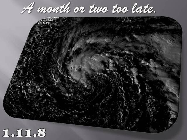
http://www.ssd.noaa.gov/goes/flt/t1/avn.jpg
Looks like a subtropical depression or maybe storm. Looks like something rare for this month. Weird weather for the tropics. I'm not kidding.
Time to label it as a invest.
Looks like a subtropical depression or maybe storm. Looks like something rare for this month. Weird weather for the tropics. I'm not kidding.
Time to label it as a invest.
0 likes
Re: Models showing storm soon?
Matt-hurricanewatcher wrote:http://www.ssd.noaa.gov/goes/flt/t1/avn.jpg
Looks like a subtropical depression or maybe storm.
Did you totally miss the TWD posted right above you? 20 KNOTS. Not a storm. Nor a depression, since NHC isn't going to call anything below 25 kt a depression.
An INVEST... perhaps, perhaps not. That's subjective. But quite clearly it's neither a storm nor a depression.
0 likes
-
Matt-hurricanewatcher
Re: Models showing storm soon?
Chacor wrote:Matt-hurricanewatcher wrote:http://www.ssd.noaa.gov/goes/flt/t1/avn.jpg
Looks like a subtropical depression or maybe storm.
Did you totally miss the TWD posted right above you? 20 KNOTS. Not a storm. Nor a depression, since NHC isn't going to call anything below 25 kt a depression.
An INVEST... perhaps, perhaps not. That's subjective. But quite clearly it's neither a storm nor a depression.
I say depression based on the quickscat 25-30 knots on the northeast side. But at least a invest. No I did not read the TWD, I can look at a system in know. I watch tropics because I enjoy doing so.
0 likes
-
Squarethecircle
- Category 5
- Posts: 2165
- Joined: Fri Oct 19, 2007 4:00 pm
- Location: Fairfax, VA
What is it with these storms and comebacks? I hold firm on death. I admit, it could possibly be tagged within a couple days, but I stand firm that there is no chance of anything coming from this.
What I find hilarious about this whole ordeal is that the CMC [to a certain extent] actually scored again, although it overestimated the intensity.
What I find hilarious about this whole ordeal is that the CMC [to a certain extent] actually scored again, although it overestimated the intensity.
0 likes
-
Coredesat
A small puff of weak convection 3 degrees SE of the diffuse low-level center does not a subtropical depression make. The loop clearly shows this weak convection getting sheared away as it flares.
Sadly, SAB has a floater over it tagged as "Invest", so let the unchecked speculation and theories begin.
Sadly, SAB has a floater over it tagged as "Invest", so let the unchecked speculation and theories begin.
Last edited by Coredesat on Sun Jan 13, 2008 1:45 pm, edited 2 times in total.
0 likes


Re: Re:
RL3AO wrote:Coredesat wrote:
Sadly, SAB has a floater over it tagged as "Invest", so let the unchecked idiotic speculation and theories begin.
Arthur at Jan 15 12z. Peaks at 85 kts.
Only 85? I'd say 100!!
0 likes
Who is online
Users browsing this forum: No registered users and 281 guests