TX winter wx thread: Spring-like pattern

Winter Weather Discussion

Moderator: S2k Moderators

Forum rules

The posts in this forum are NOT official forecast and should not be used as such. They are just the opinion of the poster and may or may not be backed by sound meteorological data. They are NOT endorsed by any professional institution or STORM2K.

Help Support Storm2K
Message
Author
Ed Mahmoud

Re: TX winter weather thread: Winter WX next Thurs/Fri?

#801 Postby Ed Mahmoud » Sun Jan 13, 2008 12:36 am

Extremeweatherguy wrote:
Ed Mahmoud wrote:Looking at raw numbers from AccuWx PPV site, temps would be above freezing by enough in DFW area that is is just a cold rain, but GFS used to sometimes be a little warm on Canadian airmasses in Texas, so sleet/snow seems possible.
What I am seeing on the pro site raw numbers indicates a great setup for some wintry weather up near Dallas. Temperatures in the 30s Wednesday evening through Thursday morning at the surface, coupled with -2 to -5C 850mb temperatures and thicknesses in the 530s would be more than capable of bringing snow flakes to the surface. Temperatures do not need to be near freezing for it to snow if the upper levels are cold enough. I personally have seen it snow with temperatures as warm as near 40F and I have seen it sleet with temperatures as warm as 45-46F, so with temperatures in the 30s in Dallas, they shouldn't have a problem (assuming the precipitation doesn't move out before it gets cold enough to support wintry weather).


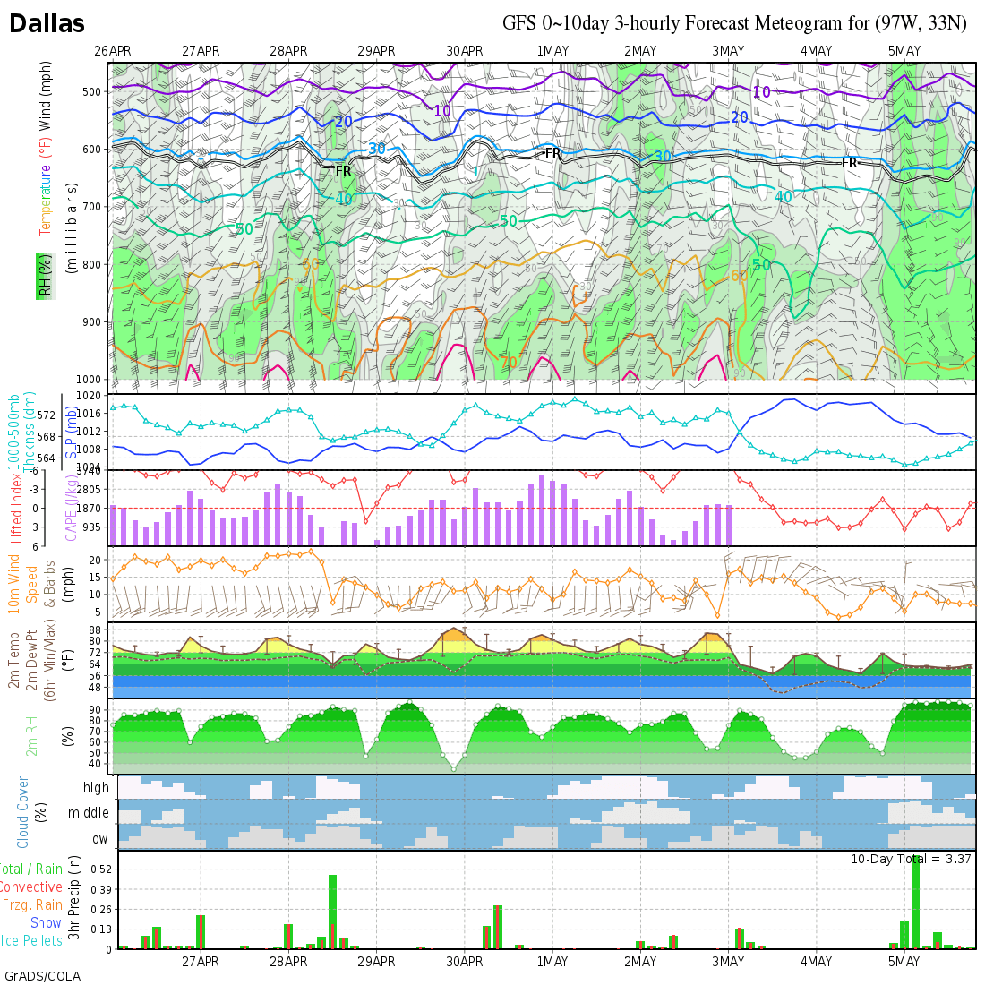
Wxmaps.org GFS meteogram does show snow. Of course, well under an inch, and with temps above freezing, may not stick.
Image
0 likes   

PineyWoods
Tropical Storm
Tropical Storm
Posts: 127
Joined: Sat Feb 03, 2007 3:39 pm
Location: Tyler

Re: TX winter weather thread: Winter WX next Thurs/Fri?

#802 Postby PineyWoods » Sun Jan 13, 2008 6:47 am

Just looking at the Shreveport AFD (that includes parts of E & NE Tex)

"Area forecast discussion
National Weather Service Shreveport la
407 am CST sun Jan 13 2008

Discussion...

As large upper trough builds over the eastern U.S. Much of the
western half of the country will be under a general northerly
steering flow. Shortwaves dropping into The Rockies over the next
few days will be the source of middle to late week weather. Extended
models still diverging on the solution beyond Wednesday.

As for Wednesday...there at least is agreement that initial
shortwave will become cutoff low over northern Mexico Monday
morning through Tuesday morning...then open and eject eastward
through Wednesday...spreading Gulf moisture and areas of precipitation
over the four state area Wednesday. At the surface...a cold front will
intrude into the northwest portion of County Warning Area through Wednesday night
... and may help the precipitation include some snow as it temporarily ends or at least
diminishes.


At this point the GFS ends precipitation and moves on with a dry end of
the week. The European model (ecmwf) however is persistently keeping the kicker
shortwave further west and S than the GFS...closing off another
weaker low over elp Thursday evening. Thus another round of light
precipitation is suggested by European model (ecmwf) Thursday afternoon through Friday
morning. If so...maybe snow again. For both potential snow events
/Wed night and Thursday night/ the primary location is still north of a
Quitman Texas to El Dorado Arkansas line. Precipitation type is iffy this far
out so still using ... rain or light snow... as the wording
of choice...and probability of precipitation are only 20 to 30 percent.
This is due
primarily to continued uncertainty and low confidence. /17/ "

Well it was only a cold rain mention yesterday, and we are getting closer .... so maybe? :wink:
0 likes   

User avatar
Portastorm
Storm2k Moderator
Storm2k Moderator
Posts: 9914
Age: 63
Joined: Fri Jul 11, 2003 9:16 am
Location: Round Rock, TX
Contact:

Re: TX winter weather thread: Winter WX next Thurs/Fri?

#803 Postby Portastorm » Sun Jan 13, 2008 8:23 am

The NWS forecast offices in Texas are "abuzz" this Sunday morning about our weather over the next week. The overall message seems to be a lot of skepticism over the 0z GFS operational run which differs greatly from the European.

Here's a few highlights for your reading pleasure!

-------------------------------------
NWSFO Amarillo --

THERE SEEMS TO BE QUITE THE DISCREPANCY AS TO JUST WHAT TYPE OF
AIRMASS THIS COLD FRONT WILL BRING. THIS FORECASTER STRONGLY AGREES
WITH WFO OUN IN THAT THE AIRMASS ASSOCIATED WITH THIS STRONG COLD
FRONT IS NOT EVEN CLOSE TO BEING ARCTIC IN ORIGIN. THE SURFACE HIGH
BUILDING IN BEHIND THIS FRONT IS DEFINITELY OF PACIFIC ORIGIN. ... EVEN THOUGH
THERE IS DISAGREEMENT AMONG MEDIUM RANGE MODELS..THEY ALL
BASICALLY AGREE ON FURTHER AMPLIFICATION OF THE LONGWAVE PATTERN FOR
LATE NEXT WEEKEND AND BEYOND..IN PARTICULAR...UPPER LEVEL RIDGING
PROGGED TO BUILD STRONGLY NWD INTO ALASKA. SHOULD THIS UPPER LEVEL
PATTERN COME TO VERIFY...THEN AN ARCITC AIRMASS MAY BECOME DISLODGED
OVER ALASKA AND NW CANADA AND HEAD SSEWD INTO THE LOWER 48. THIS
PATTERN WOULD LOOK MORE LIKE THE TRADITIONAL MCFARLAND SIGNATURE IN
TERMS OF DETERMINING WHEN AN ARCTIC AIRMASS MAY BECOME DISLODGED AND
HEAD SEWD INTO THE UNITED STATES. OF COURSE...SHOULD THIS UPPER AIR
PATTERN MATERIALIZE...THERE ARE STILL ISSUES CONCERNING HOW COLD
THIS AIRMASS WOULD BE AND HOW MUCH OF THIS WOULD AFFECT SRN HIGH
PLAINS...WITH THE OVERALL ORIENTATION AND PLACEMENT OF THE UPPER
RIDGE AXIS STRONGLY DICTATING WHERE SUCH AN AIRMASS MIGHT HEAD. THIS
IS CERTAINLY WORTH MONITORING OVER NEXT SEVERAL DAYS AS SRN HIGH
PLAINS COULD BE AFFECTED SOMETIME BEYOND THIS SEVEN DAY PACKAGE.

NWSFO San Angelo --

EXTENDED FORECAST A BIGGER PAIN...WITH LITTLE CONSISTENCY FROM
MODEL TO MODEL. HAS BEEN SOME CONSISTENCY WITHIN THE INDIVIDUAL
MODELS...MAINLY THE ECMWF...AND WITH THE NATIONAL FOLKS NOT
SHOWING A LOT OF FAITH IN THE OOZ OPERATIONAL RUN OF THE
GFS...WILL LEAN TOWARDS THE ECMWF FOR THIS FORECAST. THIS IS A
SLIGHTLY COLDER RUN...AND CARRIES AT LEAST SOME CHANCE OF WINTRY
PRECIP ACROSS THE AREA LATE WEDNESDAY NIGHT INTO THURSDAY. ALL
MODELS DO CONTINUE TO SHOW THE STRONG FRONT PUSHING THROUGH ON
WEDNESDAY...WHICH WILL MAKE HIGHS A BIT TRICKY.

GIVEN THE MODEL ISSUES...CONFIDENCE IS NOT TERRIBLY HIGH AND WILL
KEEP PRECIP CHANCES LOW AND CONFINED TO THE BIG COUNTRY FOR NOW.
WOULD NOT BE SURPRISED TO SEE THE 12Z RUNS COME IN LOOKING QUITE A
BIT DIFFERENT.

NWS Austin/San Antonio --

THERE IS GOOD CONSENSUS FROM THE 00Z MEDIUM RANGE MODEL SOLUTIONS
ON A STRONG COLD FRONT PUSHING THROUGH WEDNESDAY NIGHT...BUT POOR
CONSENSUS BEYOND 96H WITH THE GFS/NOGAPS PARTING FROM THE
ECMWF/CANADIAN SOLUTIONS. IF THE ECMWF WORKS-OUT...ISENTROPIC
UPGLIDE WILL DEVELOP BEHIND THE FRONT WEDNESDAY NIGH AND PERSIST
THROUGH EARLY FRIDAY WITH POSSIBILITIES FOR WINTER-TYPE PRECIP.
THE 00Z ECMWF ALSO SHOWS AN ARCTIC AIRMASS BLASTING THROUGH LATE
FRIDAY NIGHT INTO SATURDAY. THE GFS IS MUCH MORE TAME...WITH DRY
POST-FRONTAL CONDITIONS ON THURSDAY AND ONLY A REINFORCING SHOT OF
COLD AIR LATE FRIDAY INTO SATURDAY. THE POINT HERE IS THAT
FORECAST CONFIDENCE DROPS OFF RAPIDLY AFTER 96H...WITH THE
POTENTIAL FOR SOME SIGNIFICANT IMPACT WEATHER TOWARD THE END OF
THE WORK-WEEK AND INTO NEXT WEEKEND.

NWS Fort Worth --

THERE IS STILL A CHANCE OF SOME WINTRY PRECIPITATION ACROSS NORTH
TEXAS...MAINLY IN THE WEDNESDAY NIGHT THROUGH EARLY FRIDAY TIME
PERIOD. A MIX OF LIGHT RAIN...LIGHT SNOW...AND LIGHT SLEET IS
POSSIBLE. FORTUNATELY...PROBLEMS WITH THIS WINTRY MIX SHOULD BE
MINIMAL...AS THERE WILL BE A PAUCITY OF MOISTURE WITH THE SYSTEM.

NWS Midland/Odessa --

THE FORECAST BECOMES PROBLEMATIC WEDNESDAY NIGHT AND BEYOND AS
THE OPERATIONAL GFS40 IS MUCH MORE PROGRESSIVE WITH THE AMPLIFYING
TROUGH ACROSS THE CENTER OF THE NATION. THE ECMWF HOLDS THE TROUGH
MUCH FURTHER WEST AND GENERATES SNOW THURSDAY AND SUBSEQUENTLY MUCH
COLDER AIR THAN THE GFS40 FOR THURSDAY INTO THE EARLY PART OF THE
WEEKEND. A FEW OF THE GFS ENSEMBLE MEMBERS ON THE 00Z SUNDAY RUN
SUGGEST A FURTHER WEST POSITION OF THE TROUGH IS POSSIBLE WHILE
SEVERAL MEMBERS MIMIC THE OPERATIONAL GFS40. AT THIS POINT
HAVE DECIDED NOT TO MAKE SIGNIFICANT CHANGES TO THE FORECAST BEYOND
WEDNESDAY...THOUGH CHANGES COULD BE IN THE OFFING.
0 likes   

bktkckak
Tropical Wave
Tropical Wave
Posts: 9
Joined: Wed Dec 12, 2007 4:00 pm
Location: Tyler, TX

Re: TX winter weather thread: Winter WX next Thurs/Fri?

#804 Postby bktkckak » Sun Jan 13, 2008 8:54 am

And don't forget us East Texans!
Last edited by bktkckak on Sun Jan 13, 2008 9:34 am, edited 2 times in total.
0 likes   

User avatar
jasons2k
Storm2k Executive
Storm2k Executive
Posts: 8245
Age: 51
Joined: Wed Jul 06, 2005 12:32 pm
Location: The Woodlands, TX

Re: TX winter weather thread: Winter WX next Thurs/Fri?

#805 Postby jasons2k » Sun Jan 13, 2008 9:25 am

:uarrow:

See two posts up :D
0 likes   

User avatar
jasons2k
Storm2k Executive
Storm2k Executive
Posts: 8245
Age: 51
Joined: Wed Jul 06, 2005 12:32 pm
Location: The Woodlands, TX

Re: TX winter weather thread: Winter WX next Thurs/Fri?

#806 Postby jasons2k » Sun Jan 13, 2008 9:29 am

Seems like a lot of uncertainty. It does look like a decent threat of something towards the Metroplex and the Arklatex region, but not down here in SE Texas.

I do know this much, about a week ago I changed the title of this thread from saying "Arctic Blast 1/12-1/13".....I wore shorts yesterday and might be in shorts sleeves this afternoon :wink:
0 likes   

bktkckak
Tropical Wave
Tropical Wave
Posts: 9
Joined: Wed Dec 12, 2007 4:00 pm
Location: Tyler, TX

Re: TX winter weather thread: Winter WX next Thurs/Fri?

#807 Postby bktkckak » Sun Jan 13, 2008 9:35 am

I thought it was impossible for my attention span to get worse! Time for another New Year's resolution.
0 likes   

User avatar
Extremeweatherguy
Category 5
Category 5
Posts: 11095
Joined: Mon Oct 10, 2005 8:13 pm
Location: Florida

#808 Postby Extremeweatherguy » Sun Jan 13, 2008 10:25 am

The CPC is definitely latching on to a very cold next 2 weeks scenario...

Image
Image
0 likes   

User avatar
southerngale
Retired Staff
Retired Staff
Posts: 27418
Joined: Thu Oct 10, 2002 1:27 am
Location: Southeast Texas (Beaumont area)

Re: TX winter weather thread: Winter WX next Thurs/Fri?

#809 Postby southerngale » Sun Jan 13, 2008 11:47 am

jasons wrote:Seems like a lot of uncertainty. It does look like a decent threat of something towards the Metroplex and the Arklatex region, but not down here in SE Texas.

I do know this much, about a week ago I changed the title of this thread from saying "Arctic Blast 1/12-1/13".....I wore shorts yesterday and might be in shorts sleeves this afternoon :wink:


Yep... and why I sound like such a party pooper sometimes... I don't believe the medium to long range model runs. I was running around yesterday with my A/C going in my car.

The GFS giveth and the GFS taketh away. One of these days, it will give and mean it. I hope I'm still alive. :lol:
0 likes   

User avatar
Extremeweatherguy
Category 5
Category 5
Posts: 11095
Joined: Mon Oct 10, 2005 8:13 pm
Location: Florida

#810 Postby Extremeweatherguy » Sun Jan 13, 2008 11:52 am

The 12z GFS continues to show chilly air working into the area by Wednesday with some precipitation, but it also looks less favorable for any kind of snow or sleet reaching areas south of north Texas. For now, I think I am willing to agree with this scenario. It looks to me like the big event may be coming the week of the 21st and not this week (and based on his comments from another source, wxman57 agrees). While we will get chilly this week, I think the week of the 21st has the potential to be much, much colder. As a cross polar flow sets up next weekend, we should be in a great setup to see a "true" blast of arctic air surge southward into the United States sometime around or just after the 21st of January. Things could definitely get interesting if that kind of scenario plays out.

Overall, it looks like the next couple of weeks should be quite interesting for weather lovers. There will definitely be a lot to watch, and I do not see many dull weather moments ahead.
0 likes   

pwrdog
Tropical Storm
Tropical Storm
Posts: 193
Joined: Fri Jan 26, 2007 5:58 am
Location: Texas

Re:

#811 Postby pwrdog » Sun Jan 13, 2008 1:04 pm

Extremeweatherguy wrote:The 12z GFS continues to show chilly air working into the area by Wednesday with some precipitation, but it also looks less favorable for any kind of snow or sleet reaching areas south of north Texas. For now, I think I am willing to agree with this scenario. It looks to me like the big event may be coming the week of the 21st and not this week (and based on his comments from another source, wxman57 agrees). While we will get chilly this week, I think the week of the 21st has the potential to be much, much colder. As a cross polar flow sets up next weekend, we should be in a great setup to see a "true" blast of arctic air surge southward into the United States sometime around or just after the 21st of January. Things could definitely get interesting if that kind of scenario plays out.

Overall, it looks like the next couple of weeks should be quite interesting for weather lovers. There will definitely be a lot to watch, and I do not see many dull weather moments ahead.
I'm with you brother... I have not got my hopes up this winter watching the GFS and very rarely do But!.... The 22nd thru 26th time frame look like a winner and remind me of the 1989 set up.... We got a heck of a sleet and ice storm that year late in jan or early feb..

I like how it shows a cool down coming from the west and north instead of just down the great plains.. The great plains surges miss us or graze us more often than not..

Looks like the southern jet and the northern jet will meet over Texas as well with plenty of moisture training into the baja off the pacific......

I know it's a long way off but It's the best set up I've seen in a while because of the width of the cold air and a possible more active southern branch..

Or maybe not..
0 likes   

User avatar
wall_cloud
Professional-Met
Professional-Met
Posts: 401
Age: 48
Joined: Sun Dec 04, 2005 7:32 am
Location: Bartlett, TN
Contact:

Re: TX winter weather thread: Winter WX next Thurs/Fri?

#812 Postby wall_cloud » Sun Jan 13, 2008 2:06 pm

bktkckak wrote:And don't forget us East Texans!


I don't think that is possible. every other post is from the DFW or Houston areas. Its nice to see at least a mention of the western half of TX. It is a big state, you know
0 likes   

User avatar
jasons2k
Storm2k Executive
Storm2k Executive
Posts: 8245
Age: 51
Joined: Wed Jul 06, 2005 12:32 pm
Location: The Woodlands, TX

Re: TX winter weather thread: Colder pattern setting up

#813 Postby jasons2k » Sun Jan 13, 2008 2:13 pm

As of now, the setup does look like it will be there, but this far away, I would not put much stock into it. We have seen the same setup many times only to have the coldest air sent towards the east of us.

Don't forget the cold a couple of weeks ago looked like a 'sure thing' to some people but it ended-up being Florida's cold....time will tell.

When it's all said & done, I think areas north of Austin to Tyler have a threat of winter weather and the coldest night may give us mid-to-upper 20's, but that's as far as I'll go for now.
0 likes   

User avatar
Extremeweatherguy
Category 5
Category 5
Posts: 11095
Joined: Mon Oct 10, 2005 8:13 pm
Location: Florida

#814 Postby Extremeweatherguy » Sun Jan 13, 2008 2:38 pm

JB is really biting onto the cold this afternoon and thinks the northern plains, the pacific northwest, and parts of Canada could see some of the coldest weather they have seen in years. He also thinks a weather war will be waged from Texas to New England with areas southeast of that corridor seeing only "hit and run, back and forth" cold, while areas northwest of that corridor will see a sustained, possibly extreme, cold. For Texas in particular, we will be right on the battle ground, and that signals to me that we will likely be in a favorable area for winter weather scenarios as the systems roll through one after another. For those that like snow and especially ice, the battle ground between the cold, arctic air and the milder air is definitely one of the best (and worst - due to potential ice damage) places to be.

Overall - Based on what I am seeing/hearing from JB, wxman57, the modeling and the CPC guidance, I am beginning to think that this could potentially be the real deal this time. I am not willing to bet on that as a certainty just yet, but if things look the same by the end of this week, then we may have to seriously consider a prolonged period of cloudy, cold and possibly wintry days down here in Texas a real possibility.
Last edited by Extremeweatherguy on Sun Jan 13, 2008 2:45 pm, edited 1 time in total.
0 likes   

User avatar
southerngale
Retired Staff
Retired Staff
Posts: 27418
Joined: Thu Oct 10, 2002 1:27 am
Location: Southeast Texas (Beaumont area)

Re:

#815 Postby southerngale » Sun Jan 13, 2008 2:44 pm

Extremeweatherguy wrote: For those that like snow and especially ice, the battle ground between the cold, arctic air and the milder air is definitely one of the best (and worst - due to potential ice damage) places to be.


I've got ice in my freezer. :ggreen:

Bring on the snow!
0 likes   

User avatar
jasons2k
Storm2k Executive
Storm2k Executive
Posts: 8245
Age: 51
Joined: Wed Jul 06, 2005 12:32 pm
Location: The Woodlands, TX

Re: TX winter weather thread: Winter WX next Thurs/Fri?

#816 Postby jasons2k » Sun Jan 13, 2008 2:50 pm

wall_cloud wrote:
bktkckak wrote:And don't forget us East Texans!


I don't think that is possible. every other post is from the DFW or Houston areas. Its nice to see at least a mention of the western half of TX. It is a big state, you know


FWIW neither residents of the Metroplex nor Houston consider themselves as part of "East Texas".

DFW = North Texas or more specifically, North Central Texas
Houston = SE Texas and sometimes the Upper TX Coast
East Texas = Tyler, Longview, Lufkin, Palestine, Nacagdoches, San Augustine

Outsiders may geographically consider anywhere east of I-35 or I-45 as "East Texas" but locals only consider "East Texas" to be what's indicated on the map here:

http://en.wikipedia.org/wiki/Deep_East_Texas
0 likes   

User avatar
jasons2k
Storm2k Executive
Storm2k Executive
Posts: 8245
Age: 51
Joined: Wed Jul 06, 2005 12:32 pm
Location: The Woodlands, TX

#817 Postby jasons2k » Sun Jan 13, 2008 2:54 pm

:shrug: there goes JB again playing to the most extreme scenario. I can't count how many times he's uttered 1899 or 1983 and I have not seen it yet since I first read him 9 years ago.
0 likes   

Brent
S2K Supporter
S2K Supporter
Posts: 38090
Age: 36
Joined: Sun May 16, 2004 10:30 pm
Location: Tulsa Oklahoma
Contact:

Re:

#818 Postby Brent » Sun Jan 13, 2008 3:09 pm

jasons wrote::shrug: there goes JB again playing to the most extreme scenario. I can't count how many times he's uttered 1899 or 1983 and I have not seen it yet since I first read him 9 years ago.


LOL... if he DIDN'T go with some extreme scenario I'd think something was wrong. :roll:

Yeah, I'll believe the 10-day GFS when I see it. It was just a couple of days ago the 7-day GFS buried Texas to the Carolinas in a foot of snow, and now it's all gone. :grr:
0 likes   

User avatar
wall_cloud
Professional-Met
Professional-Met
Posts: 401
Age: 48
Joined: Sun Dec 04, 2005 7:32 am
Location: Bartlett, TN
Contact:

Re: TX winter weather thread: Winter WX next Thurs/Fri?

#819 Postby wall_cloud » Sun Jan 13, 2008 3:14 pm

jasons wrote:
wall_cloud wrote:
bktkckak wrote:And don't forget us East Texans!


I don't think that is possible. every other post is from the DFW or Houston areas. Its nice to see at least a mention of the western half of TX. It is a big state, you know


FWIW neither residents of the Metroplex nor Houston consider themselves as part of "East Texas".

DFW = North Texas or more specifically, North Central Texas
Houston = SE Texas and sometimes the Upper TX Coast
East Texas = Tyler, Longview, Lufkin, Palestine, Nacagdoches, San Augustine

Outsiders may geographically consider anywhere east of I-35 or I-45 as "East Texas" but locals only consider "East Texas" to be what's indicated on the map here:

http://en.wikipedia.org/wiki/Deep_East_Texas


I'm quite aware of that. I've lived in Houston. But relative to the remainder of the state, they are in the eastern half. Back to the -removed- :ggreen:
0 likes   

User avatar
weatherrabbit_tx
Category 1
Category 1
Posts: 270
Joined: Wed Dec 21, 2005 3:13 pm
Location: Kingwood,Tx
Contact:

Re: TX winter weather thread: Colder pattern setting up

#820 Postby weatherrabbit_tx » Sun Jan 13, 2008 3:31 pm

here at lake conroe, we could be southeast texas or on the fringe of the deep piney woods, but lake or no lake it gets cold. its still a week away about all this arctic air will see how it goes
0 likes   


Return to “Winter Weather”

Who is online

Users browsing this forum: No registered users and 15 guests