January 19-20, 2008 Snowstorm: Initial Thoughts

Winter Weather Discussion

Moderator: S2k Moderators

Forum rules

The posts in this forum are NOT official forecast and should not be used as such. They are just the opinion of the poster and may or may not be backed by sound meteorological data. They are NOT endorsed by any professional institution or STORM2K.

Help Support Storm2K
Message
Author
donsutherland1
S2K Analyst
S2K Analyst
Posts: 2718
Joined: Mon Sep 15, 2003 8:49 pm
Location: New York

January 19-20, 2008 Snowstorm: Initial Thoughts

#1 Postby donsutherland1 » Thu Jan 17, 2008 1:40 pm

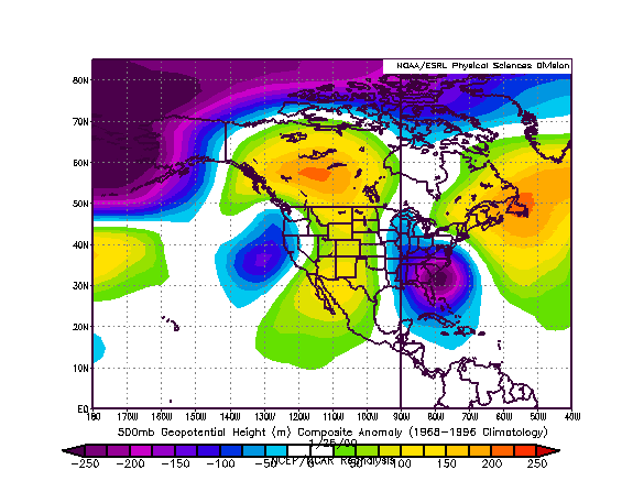
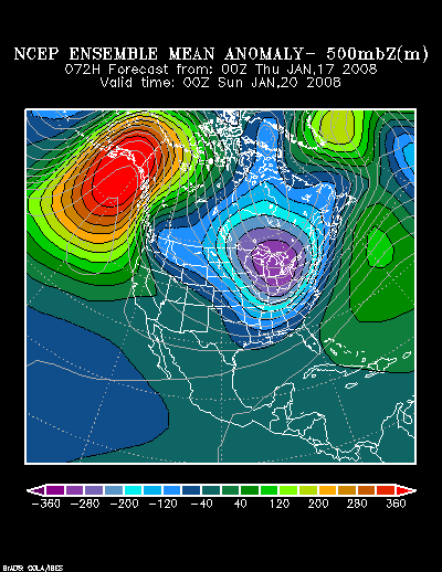
The forecast synoptic situation for the period in question bears some broad similarities to that which was present in eastern North America and the western Atlantic Ocean on January 22, 1987.

NCEP Ensemble Mean 500 mb Height Anomalies forecast for 1/20/2008 0z:
Image

500 mb Height Anomalies on 1/22/1987:
Image

This would indicate the possibility of a classic Mid-Atlantic-centered snowstorm. In 1987, a snowstorm dumped 6” or more in the Mid-Atlantic region, including the area running from Richmond to New York City.

Boston: 5.3”
Bridgeport: 5.6”
New York City: 8.1”
Philadelphia: 8.8”
Providence: 5.5”
Richmond: 7.4”
Washington, DC (DCA): 10.8”

If the storm dumps 4” or more in Richmond, it would be that city’s biggest snowstorm in more than two years, even if the wait seemed more like, let’s say forever. The last time Richmond saw 4” or more snow was December 5-6, 2005 when 4.2” fell. The last time Richmond picked up 6” or more snow was January 3, 2002 when 7.7” accumulated.

Following the storm, an Arctic air mass pushed into the East. The lowest readings in the 1/23-25 timeframe were as follows:

Boston: 9°
Bridgeport: 7°
New York City: 8°
Philadelphia: 9°
Providence: 6°
Richmond: 7°
Washington, DC (DCA): 9°

Unlike 1987, it appears that the storm will track a little farther offshore. Hence, it is possible that the immediate coast will wind up with the largest snowfalls once one moves into the northern Mid-Atlantic and southern New England regions. If so, Cape Cod and Nantucket could have greater accumulations than Boston and Long Island could receive more snow than New York City.

At this time, my initial thinking with respect to the 1/19-20/2008 event is as follows:

High risk of 4” or more; Moderate risk of 6” or more:
Atlantic City, Richmond, Washington, DC (DCA and IAD)

High risk of 2” or more; Moderate risk of 4” or more:
Allentown, Baltimore, Boston, Bridgeport, Islip, New York City, Newark, Philadelphia, Providence

It should be noted that both the GFS and NAM have been trending toward a more significant event. The NAM already provides a significant snowfall for parts of the Mid-Atlantic region into southern New England. The GFS has been trending more slowly in that direction. In any case, should the storm meet its full potential, some locations could pick up 10” or more of snow.
0 likes   

hcaebmub
Tropical Wave
Tropical Wave
Posts: 7
Joined: Mon Aug 13, 2007 7:49 pm

Re: January 19-20, 2008 Snowstorm: Initial Thoughts

#2 Postby hcaebmub » Thu Jan 17, 2008 2:05 pm

Don,
How about the NC/SC area. Do you see that area receiving any significant snowfall?
0 likes   

Coredesat

#3 Postby Coredesat » Thu Jan 17, 2008 2:34 pm

What impact will forecast highs in the upper 50's to lower 60's tomorrow have on the forecast snowfall totals?
0 likes   

Coredesat

#4 Postby Coredesat » Fri Jan 18, 2008 4:16 am

00Z GFS, 06Z NAM, and 00Z Euro have been leaning toward a bust for this area due to the low tracking further to the SE than in previous runs. NWS is already expecting no accumulation in the Richmond area.
0 likes   

User avatar
brunota2003
S2K Supporter
S2K Supporter
Posts: 9476
Age: 34
Joined: Sat Jul 30, 2005 9:56 pm
Location: Stanton, KY...formerly Havelock, NC
Contact:

#5 Postby brunota2003 » Fri Jan 18, 2008 4:32 am

I live right on the coast of NC (Between Morehead City and New Bern) and our local NWS is saying maybe a brief switch over from rain to snow right at the very end, but nothing more than that.

Anyone think otherwise?
NWS Newport/Morehead City AFD:

.SHORT TERM /6 PM THIS EVENING THROUGH SATURDAY NIGHT/...
-- Changed Discussion --
LOW PRES SYSTEM WILL BE ORGANIZING IN THE WESTERN GULF TONIGHT
AND GATHER STRENGTH AS IT MOVES ALONG OR JUST OFF SE COAST ON
SATURDAY. TONIGHT LOOKS TO BE MAINLY DRY AS IT WILL TAKE SOME TIME
FOR THE LOW LEVELS TO RE-MOISTEN. HAVE UPPED POPS FOR SATURDAY
INTO CATEGORICAL RANGE GIVEN THE GOOD MODEL AGREEMENT FOR A RAINY
DAY. GOOD MOISTURE INFLOW INTO THE SYSTEM SUGG POTENTIAL FOR ANTHR
BENEFICIAL RAINFALL WITH QPF AMOUNTS AROUND AN INCH. A COLD RAIN
WITH LOW PRES STAYING ALONG THE COAST OR JUST OFFSHORE...MUCH OF
THE AREA REMAINS IN THE M-U40S ON SAT WITH L50S ALONG THE COAST.

CRITICAL PARTIAL THICKNESS FOR CHANGEOVER TO SNOW PUSHES TO COAST
AS DEEPER MOISTURE MOVES OUT SAT NITE. PCPN MAY END AS A PERIOD OF
SNOW OR A RAIN/SNOW MIX BUT ANY FROZEN PCPN LIKELY NOT HEAVY ENUF
NOR LONG LASTING ENUF FOR ANY ACCUM. STRONG CAA KICKS IN LATE WITH
LOWS REACHING IN THE M-U20S/L30S ALONG THE COAST BY SUNRISE SUNDAY
MORN.

Now what is interesting to note, is it seems we always get our deepest snows when they either are calling for just rain or a rain/snow mix right at the very end. So it'll be fun to watch if this one plays out as said above, or if it surprises us? We'll see...
0 likes   

User avatar
intricate
Tropical Low
Tropical Low
Posts: 10
Joined: Sat Sep 11, 2004 4:52 pm
Location: North Carolina

Re: January 19-20, 2008 Snowstorm: Initial Thoughts

#6 Postby intricate » Fri Jan 18, 2008 8:06 am

Winter Storm Watch for parts of Central North Carolina (I hope this will be better than what we got yesterday!!! :D :D :D )

...WINTER STORM POSSIBLE OVER PORTIONS OF CENTRAL NORTH CAROLINA
ON SATURDAY...

.A LOW PRESSURE SYSTEM IS FORECAST DEVELOP OVER THE NORTHERN GULF OF
MEXICO FRIDAY NIGHT AND MOVE NORTHEAST TO JUST OFFSHORE OF THE
NORTH CAROLINA COAST BY SATURDAY AFTERNOON. PRECIPITATION
GENERATED BY THIS AREA OF LOW PRESSURE WILL COMBINE WITH VERY COLD
AIR OVERSPREADING THE REGION TO PRODUCE THE POTENTIAL FOR SNOW
ACROSS PORTIONS OF NORTH CAROLINA.

NCZ007>011-021>027-038>041-073>076-083-084-182115-
/O.NEW.KRAH.WS.A.0002.080119T1100Z-080119T2300Z/
PERSON-GRANVILLE-VANCE-WARREN-HALIFAX-FORSYTH-GUILFORD-ALAMANCE-
ORANGE-DURHAM-FRANKLIN-NASH-DAVIDSON-RANDOLPH-CHATHAM-WAKE-STANLY-
MONTGOMERY-MOORE-LEE-ANSON-RICHMOND-
INCLUDING THE CITIES OF...ROXBORO...OXFORD...HENDERSON...
WARRENTON...ROANOKE RAPIDS...WINSTON-SALEM...GREENSBORO...
HIGH POINT...BURLINGTON...CHAPEL HILL...DURHAM...LOUISBURG...
NASHVILLE...LEXINGTON...ASHEBORO...PITTSBORO...RALEIGH...
ALBEMARLE...TROY...SOUTHERN PINES...SANFORD...WADESBORO...
ROCKINGHAM
426 AM EST FRI JAN 18 2008

...WINTER STORM WATCH IN EFFECT FROM SATURDAY MORNING THROUGH
SATURDAY AFTERNOON...

THE NATIONAL WEATHER SERVICE IN RALEIGH HAS ISSUED A WINTER STORM
WATCH...WHICH IS IN EFFECT FROM SATURDAY MORNING THROUGH SATURDAY
AFTERNOON.

PRECIPITATION IS EXPECTED TO OVERSPREAD CENTRAL NORTH CAROLINA
DURING THE DAY ON SATURDAY. AS IT DOES SO...MUCH COLDER AIR WILL
SPREAD INTO THE AREA FROM THE WEST. THE AIRMASS APPEARS TO BE COLD
ENOUGH AT THE ONSET OF THE EVENT SATURDAY MORNING FOR MOST OF THE
PRECIPITATION TO FALL AS SNOW ACROSS THE WESTERN PIEDMONT. FURTHER
EAST TOWARD THE NORTHERN PIEDMONT AND NORTHEAST COASTAL PLAIN...THE
PRECIPITATION WILL LIKELY START OUT AS A COLD RAIN SATURDAY MORNING
BUT SHOULD CHANGE OVER TO SNOW DURING THE LATE MORNING OR EARLY
AFTERNOON.

SNOWFALL ACCUMULATIONS OF 2 TO 4 INCHES ARE POSSIBLE...WHICH COULD
CAUSE SIGNIFICANT IMPACTS TO TRAVEL.

SOME UNCERTAINTY STILL EXISTS WITH THIS EVENT. THE EXACT TRACK OF
THE SURFACE LOW AND THE TIMING OF THE COLDER AIR WILL ULTIMATELY
DETERMINE THE SNOWFALL ACCUMULATION POTENTIAL.

A WINTER STORM WATCH MEANS THERE IS A POTENTIAL FOR SIGNIFICANT
SNOW...SLEET...OR ICE ACCUMULATIONS THAT MAY IMPACT TRAVEL.
CONTINUE TO MONITOR THE LATEST FORECASTS.

$$

JFB/RHJ
0 likes   

User avatar
terstorm1012
S2K Supporter
S2K Supporter
Posts: 1314
Age: 43
Joined: Fri Sep 10, 2004 5:36 pm
Location: Millersburg, PA

#7 Postby terstorm1012 » Fri Jan 18, 2008 8:52 am

oh my goodness. The 1987 storm that you mention, that's my earliest snow storm memory. I had just developed an interest in meteorology that year and watched the weather. My mom was taking me to school (I was in kindergarden I think) and I said "It's going to snow today," and she said "No it's not." (None of the weather forecasters forecasted much.) Then the flakes began to fall, real snow-flurry like.

By noon, Philadelphia was pretty much paralyzed. It took almost 4 hours for the school bus to drop me off at my sitter's house. Some parts of the city got over a foot, and I didn't have to go to school again the next day.

I think it snowed again a couple days later too. :lol:
0 likes   

donsutherland1
S2K Analyst
S2K Analyst
Posts: 2718
Joined: Mon Sep 15, 2003 8:49 pm
Location: New York

#8 Postby donsutherland1 » Fri Jan 18, 2008 12:26 pm

Contrary to some enticing model runs yesterday, the guidance has returned to its earlier idea of a storm that will largely impact the Southeast and lower Mid-Atlantic region. Therefore, consistent with most such events that focus their heaviest snows on that part of the East, snowfall amounts will likely rapidly diminish once one moves northward in the Mid-Atlantic region.

Nevertheless, the storm could be special for a few areas that have not seen many significant snowfalls in recent years. Some of the below cities may have a shot at picking up 4” or more snowfall depending on the storm’s track and whether or not sufficient cold air is present during the height of the precipitation.

Most recent snowstorm with 4” or more snowfall:
Asheville: 4.4”, January 25-28, 2004
Atlanta: 4.6”, January 2-3, 2002
Birmingham: 13.0”, March 12-13, 1993
Charlotte: 12.0”, February 26-27, 2004
Norfolk: 5.0”, December 26, 2004
Raleigh: 6.5”, February 26-27, 2004
Richmond: 4.2”, December 5-6, 2005

Most recent snowstorm with 6” or more snowfall:
Asheville: 14.0”, January 27, 1998
Atlanta: 7.9”, March 24, 1983
Birmingham: 13.0”, March 12-13, 1993
Charlotte: 12.0”, February 26-27, 2004
Norfolk: 7.2”, January 3-4, 2002
Raleigh: 6.5”, February 26-27, 2004
Richmond: 7.7”, January 3, 2002

Given the latest guidance, synoptic pattern, and some weight given to historical climatology, my initial snowfall estimates are as follows:

Asheville: 2”-4”
Atlanta: 2”-4”
Birmingham: 1”-3”
Charlotte: 3”-6”
Columbia: 1” or less
Norfolk: 2”-4”
Raleigh: 3”-6”
Richmond: 1”-3”

The potential exists for greater accumulations at such locations as Atlanta, Charlotte, Norfolk, and Raleigh. The 6z and 12z runs of the NAM bring much larger accumulations to those cities.

Some recent Lower Mid-Atlantic Snowstorms:

February 26-27, 2004:
A snowfall for the record books trapped ambulances in icy drifts, stranded hundreds of travelers on highways and at airports, and will leave roads slick and scary this morning until higher temperatures melt it away in a slushy mess.

Parts of the region saw more snow fall in a 24-hour period Thursday and Friday morning than they have since 1902. South Charlotte had nearly a foot and a half of snow, while reports of 21 inches came from parts of Upstate South Carolina.

Another inch or so fell Friday afternoon across the region in giant fluffy flakes, delighting kids home from school and handing road crews -- already short on sleep and road salt -- another round of plowing…


Source: Scott Dodd and Peter Smolowitz, “Near-Record Snowfall Slows Travel, Closes Offices in Charlotte, N.C.,” The Charlotte Observer, February 28, 2004.

January 23, 2003: Outer Banks:
The arctic air that has had the East and Plains shivering for days spilled into the South on Thursday, bringing rare snowdrifts to North Carolina's Outer Banks and sending Florida citrus growers scrambling to save their freezing crops.

The first significant snowfall along the North Carolina coast in 13 years brought up to a foot of snow to the barrier islands.


Source: ”Cold brings snow, imperils citrus crop,” Chicago Tribune, January 24, 2003

January 3-4, 2002:
The snowstorm that brought much of the South to a standstill moved offshore, but cold air in its wake threatened to refreeze the slush and extend the misery.

Sunny skies began melting the remnants of the two-day storm that dumped up to 16 inches of snow in parts of Virginia, North Carolina, South Carolina and Georgia…


Source: “The Nation; In Brief/The South,” Los Angeles Times, January 5, 2002

January 24-25, 2000:
An unexpectedly fast-moving nor'easter charged up the East Coast Tuesday with more than a foot of wind-blown snow, closing airports and thousands of schools and making the morning commute dangerous.

Tens of thousands of people were without power.

Snow had already fallen 18 inches deep in North Carolina, and more than a foot was possible in New England by Tuesday night. Wind gusting to 30 m.p.h. made it feel well below zero from New Jersey to New England.

"People kept saying, `We haven't had winter,"' said Richard Jones, a forecaster with the National Weather Service in Raleigh, N.C. "I guess this will show them."

The snow even affected the presidential campaign. Most of the candidates flew to New Hampshire overnight after the Iowa caucuses, but Republican Alan Keyes was stuck in Detroit in late morning, trying to fly into Boston.

Thomas Allen looked out his front door this morning in Raleigh and knew immediately he wouldn't make it to work. "The snow has completely covered my car," he said. "It's gone. I can't even see it."

Snowfall totals of 14 inches were forecast for Virginia and the Washington suburbs, with 18 inches possible in eastern Pennsylvania.


Source: ”Blizzard Batters East Coast Cities With Snow, Cold,” Chicago Tribune, January 25, 2000.
0 likes   
Brent
S2K Supporter
S2K Supporter
Posts: 38087
Age: 36
Joined: Sun May 16, 2004 10:30 pm
Location: Tulsa Oklahoma
Contact:

Re: January 19-20, 2008 Snowstorm: Initial Thoughts

#9 Postby Brent » Fri Jan 18, 2008 12:29 pm

Thanks Don, I've been wondering your opinions on the snowstorm down here. Hope you're right. :cheesy:
0 likes   

Coredesat

#10 Postby Coredesat » Fri Jan 18, 2008 1:02 pm

Wakefield has issued a winter storm watch for extreme southeastern Virginia. NWS is still saying little or no accumulation for Richmond (in other words, our streak of days without measurable snow continues).

12Z GFS is warmer and even further off the coast. 12Z NAM track is similar to the 06Z one but is also much warmer.
0 likes   

User avatar
brunota2003
S2K Supporter
S2K Supporter
Posts: 9476
Age: 34
Joined: Sat Jul 30, 2005 9:56 pm
Location: Stanton, KY...formerly Havelock, NC
Contact:

#11 Postby brunota2003 » Fri Jan 18, 2008 1:12 pm

Well, this is certainly interesting. Was just looking at the ETA (NAM) and GFS on another site...Both seem to want to hang on to the moisture around here until roughly Sunday morning, unlike yesterday where it was all supposed to be done before 1 am. The interesting thing though, is that sometime Sat evening, both show a changeover to snow. The critical thickness is going to be close, a few hours either way could be the difference between possibly a "good" snow and nothing measurable, as it wants to hang around either just west of the coast (boo) or on the coast itself. I want it off the coast, so we can get more snow...haha. This afternoons update from the NWS in Newport (around 4 pm or so) ought to be very interesting.
0 likes   

Wannabewxman79
Tropical Storm
Tropical Storm
Posts: 181
Joined: Wed Sep 17, 2003 12:53 pm
Location: Riegelwood, NC (20 miles W of Wilmington)

Re: January 19-20, 2008 Snowstorm: Initial Thoughts

#12 Postby Wannabewxman79 » Fri Jan 18, 2008 1:25 pm

I just have a quick question. We here in SE NC don't get much snow but it is crazy to me that places like New Orleans, Houston, Charleston,SC, parts of Florida have gotten snow since we last received anything of significance. Is there a reason we have been so snow poor lately considering everyone else getting snow or am I just bitter? :D
0 likes   

donsutherland1
S2K Analyst
S2K Analyst
Posts: 2718
Joined: Mon Sep 15, 2003 8:49 pm
Location: New York

#13 Postby donsutherland1 » Fri Jan 18, 2008 6:29 pm

Wannabewxman79,

It's just tough to get a favorable synoptic pattern for that part of NC.
0 likes   

donsutherland1
S2K Analyst
S2K Analyst
Posts: 2718
Joined: Mon Sep 15, 2003 8:49 pm
Location: New York

#14 Postby donsutherland1 » Fri Jan 18, 2008 6:30 pm

Final estimates:

Asheville: 1”-3”
Atlanta: 2”-4”
Birmingham: 1”-3”
Charlotte: 2”-4”
Columbia: 1” or less
Norfolk: 3”-6”
Raleigh: 3”-6”
Richmond: 0.5”-1.5”
0 likes   

VoodooCadillac
Tropical Depression
Tropical Depression
Posts: 82
Joined: Wed Dec 14, 2005 8:56 pm
Location: Fort Collins, Colorado

Re: January 19-20, 2008 Snowstorm: Initial Thoughts

#15 Postby VoodooCadillac » Sat Jan 19, 2008 1:22 pm

Don - as always, thanks. You know it's truly a southern snowstorm when Asheville is on the northwestern fringe of the precip. Your final Asheville prediction I think will end up being very accurate.

It's an interesting, and different situation than the storm earlier in the week. I did an abbreviated version of my Saturday bike ride early this morning - and somewhat surprisingly, the wind was out of the north (telling me the Artic air is oozing in - and overcoming the normal southwest flow with these type of events). Also - unlike Thursday, there's definitely NOT an inversion. I topped out at 3200 feet over Elk Mountain, and it was noticeably colder than in the valleys. It was spectatculer looking to the southwest and seeing the Balsam's and Mount Pisgah gradually disappear as snow levels dropped (the RH was very low this morning - so it took a while for the snow to reach the valley floors). Also - the storm appears to be moving very fast!
0 likes   

Coredesat

#16 Postby Coredesat » Sat Jan 19, 2008 1:58 pm

So far we have not had any precipitation of any kind in western Richmond. The radar shows plenty of rain that isn't reaching the ground. Temperatures are still above freezing, so I'm not sure there will be even half an inch of snow when all is said and done.
0 likes   

Coredesat

#17 Postby Coredesat » Sat Jan 19, 2008 2:23 pm

I spoke too soon, we're getting snow flurries now. The fact that it didn't rain could increase our snowfall totals if the snow becomes heavier.
0 likes   

Coredesat

#18 Postby Coredesat » Sat Jan 19, 2008 5:17 pm

Heavy wet snow, no significant accumulations. Perhaps a quarter of an inch on some grassy surfaces.
0 likes   

User avatar
Lowpressure
S2K Supporter
S2K Supporter
Posts: 2032
Age: 58
Joined: Sun Sep 14, 2003 9:17 am
Location: Charlotte, North Carolina

Re: January 19-20, 2008 Snowstorm: Initial Thoughts

#19 Postby Lowpressure » Sat Jan 19, 2008 6:09 pm

Maybe 1/2 inch here in Charlotte. It was pretty to watch fall but too warm. Large model error in this area. Interesting enough, the NWS mentions three more opportunities for winter precip this week!
0 likes   

Coredesat

#20 Postby Coredesat » Sat Jan 19, 2008 7:10 pm

Little in the way of accumulation, but the snow made for great photos.

Image

Image

Image
0 likes   


Return to “Winter Weather”

Who is online

Users browsing this forum: Google Adsense [Bot], Quixotic and 3 guests