 The posts in this forum are NOT official forecast and should not be used as such. They are just the opinion of the poster and may or may not be backed by sound meteorological data. They are NOT endorsed by any professional institution or

A more detailed look at those suggestions follows, even as the timeframe in question is beyond that for the extended idea.
The GWO (Global Wind Oscillation) moved into Phase 3 on January 15 and then raced into Phase 4 on January 18.
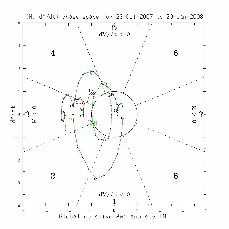
According to the CDC's description of the Global Synoptic Dynamic Model (GSDM), the GWO generally takes 15-80 days to complete its cycle. The CDC website explains:
The four primary phases of the GWO are described below, along with generally cold season (November-March) probable weather impacts for the USA. The GWO recurrence interval, or "time it takes to make a circuit", ranges from a broad 15-80 days.
Given that there are 8 Phases in the cycle, this would suggest that the GWO takes between around 2-10 days to go through each cycle. Assuming an average of 6 days, one would likely see the GWO move into the transitional Phase 5 within a few days. An important caveat is in order: the timing concerns averages, only. The GWO lingered in Stages 3 and 4 from around December 10, 2007 through January 3, 2008. Phases 3 and 4 are generally warm ones for the East. It will be interesting to see what the lag is between when the GWO moves into Phases 3 and 4 and the actual weather that occurs downstream in response.
For example, New York City came out of its general tendency for cold anomalies around 12/19. That was 9 days after the GWO had moved into Phase 3 according to the diagram. Such a lag would suggest that, given the GWO’s having moved into Phase 3 on 1/15, that NYC would see milder anomalies return in the 1/24-1/26 timeframe. That is the milder pattern that is likely to predominate through much or all of the first week of February.
Afterward, using the same lag, by the time the GWO moves into Phase 6 around the end of January, one might expect to see a transition toward colder weather in the East perhaps beginning around February 10 +/- a few days. One would first begin to see the cold anomalies appear in the central United States consistent with Stage 2 of the GWO as per the CDC description of the GSDM noted above.
In addition, after spending 13 days in Phase 7, the Madden-Julian Oscillation (MJO) shifted into Phase 8. Toward the latter part of the first week or the beginning of the second week in February, the MJO could be moving into Phase 2. If so, that could also feature the development of below normal height anomalies in eastern North America.
February 500 mb Height Anomalies for MJO Phase 2:
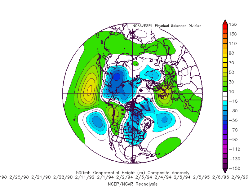
Source: RaleighWX’s MJO Composites
Phase 3 also features below normal height anomalies in a portion of eastern North America and above normal height anomalies for Greenland. It could be during this phase that a blocking episode might occur. If blocking is likely to develop, one should begin to see increasing signs of it on the guidance and in the synoptic pattern as the calendar progresses toward and into February.
For now, a mild pattern looks likely for the first week in February. During that time, the Pacific Northwest and East Coast look to be wetter than normal. There is the chance of a high impact precipitation event in the East during the first week in February. Unfortunately, with a noted absence of blocking and lack of cold, the big cities of the East would probably see mainly rain, though Boston might benefit from its higher latitude. The period could end with falling temperatures.
Average Regional Temperature Anomalies:
Northeast: Somewhat above normal
Mid-Atlantic: Somewhat above normal
Southeast: Somewhat above normal
Great Lakes: Near normal to somewhat above normal
Northern Plains: Near normal
Central Plains: Near normal to somewhat above normal
Southern Plains: Somewhat above normal
Pacific Northwest: Somewhat below normal
Southwest/Rest of West Coast: Near normal to somewhat above normal
Best Guess of Regional Temperature Anomalies (°F):
Northeast: +1° to +3°
Mid-Atlantic: +1° to +3°
Southeast: +1° to +3°
Great Lakes: 0° to +2°
Northern Plains: -1° to +1°
Central Plains: 0° to +2°
Southern Plains: +1° to +3°
Pacific Northwest: -3° to 1°
Southwest/Rest of West Coast: 0° to +2°


