
ENSO Updates (2007 thru 2023)
Moderator: S2k Moderators
Forum rules

The posts in this forum are NOT official forecasts and should not be used as such. They are just the opinion of the poster and may or may not be backed by sound meteorological data. They are NOT endorsed by any professional institution or STORM2K. For official information, please refer to products from the National Hurricane Center and National Weather Service.
-
wxman57

- Moderator-Pro Met

- Posts: 23173
- Age: 68
- Joined: Sat Jun 21, 2003 8:06 pm
- Location: Houston, TX (southwest)
Re: ENSO Updates
I think it's safe to say La Nina will continue for at least a few more months. CPC's forecasts have been pretty bad the past few years, but here's the latest - a peak of -2.5 in March then a very slow rise in temps to about where we are now in October (-1.5).
0 likes

Re: ENSO Updates
CPC still going for a record breaking la nina depsite the fact its been doing that every single monthly update for the last 5 months. I think Jim is right and that this has matured and if thats the case slow weakening should kick in Feb/March, though I have a feeling we will hang around the lower end of weak La Nina for a lot of 08.
0 likes
-
cycloneye

- Admin

- Posts: 149402
- Age: 69
- Joined: Thu Oct 10, 2002 10:54 am
- Location: San Juan, Puerto Rico
Re: ENSO Updates
January 10 Update from Climate Prediction Center for ENSO

Over half of the models predict a moderate strength La Niña to continue through February-April, followed by weaker La Niña conditions. Current atmospheric and oceanic conditions and recent trends are consistent with a likely continuation of La Niña into the Northern Hemisphere spring 2008.
No change from the december update from CPC,as they continue to say,Moderate La Nina thru the northern hemisphere spring with a weaker one after that.
0 likes
-
cycloneye
- Admin
- Posts: 149402
- Age: 69
- Joined: Thu Oct 10, 2002 10:54 am
- Location: San Juan, Puerto Rico
Re: ENSO Updates


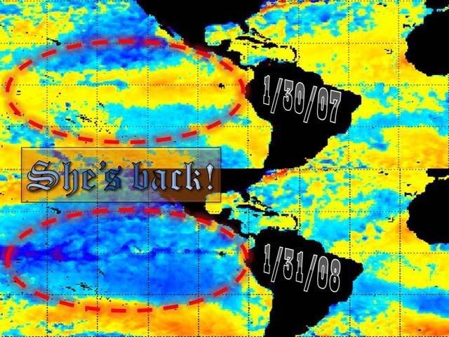
Look how La Nina has expanded westward and it looks like it will be out there for a while.
0 likes
-
cycloneye
- Admin
- Posts: 149402
- Age: 69
- Joined: Thu Oct 10, 2002 10:54 am
- Location: San Juan, Puerto Rico
Re: ENSO Updates
BoM 1/23/08 Update
La Nina thru late Spring is what they say in this update,and that is not new since they said the same in the last one.
La Nina thru late Spring is what they say in this update,and that is not new since they said the same in the last one.
0 likes
-
cycloneye
- Admin
- Posts: 149402
- Age: 69
- Joined: Thu Oct 10, 2002 10:54 am
- Location: San Juan, Puerto Rico
Re: ENSO Updates=CPC Latest Update=Strong La Nina now
Climate Prediction Center ENSO Update
Umm,Strong La Nina.This is a change from their past weeks moderate La Nina talk.The big question is if La Nina will persist going into the summer months.
Umm,Strong La Nina.This is a change from their past weeks moderate La Nina talk.The big question is if La Nina will persist going into the summer months.
0 likes


-
Coredesat
Re: ENSO Updates=CPC Latest Update=Strong La Nina now
cycloneye wrote:Climate Prediction Center ENSO Update
Umm,Strong La Nina.This is a change from their moderate La Nina talk.The big question is if La Nina will persist going into the summer months.
I'm having a lot of trouble seeing a strong La Nina with the subsurface anomalies west of 160W getting much warmer and deeper. I think neutral is more likely, but I'll withhold judgment until the next BOM wrap-up (BOM tends to handle these forecasts much better than CPC does). Granted, I'm not expecting the SOI to rapidly tank like it did in 2006 (15.2 in May to -9.8 in June).
0 likes
-
MiamiensisWx
Re: ENSO Updates
cycloneye wrote:Climate Prediction Center ENSO Update
Umm,Strong La Nina.This is a change from their past weeks moderate La Nina talk.The big question is if La Nina will persist going into the summer months.
You're thinking about two different things.
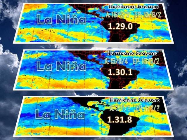
Technically, it's not a strong Nina; 3.4 has dipped below the strong Nina threshold (-1.5 degrees Celsius), which is mentioned in the report. There is a difference between strong conditions and a strong event. The Nina needs to maintain its current strength for three months in order to be classified as an "official" strong event. The CPC guidelines say, "By historical standards, to be classified as a full-fledged El Niño or La Niña episode, these thresholds must be exceeded for a period of at least 5 consecutive overlapping 3-month seasons. CPC considers El Niño or La Niña conditions to occur when the monthly Niño3.4 SST departures meet or exceed +/-0.5°C along with consistent atmospheric features." The latest PDF update states that "strong La Niña conditions" are present. This statement implies that atmospheric and oceanic conditions are typical of a mature, strong La Nina. Regardless, it looks like it will be a close call. The warm subsurface anomalies further west are meaningless, and they are actually quite typical in some strong, west-based La Nina episodes. This Nina has relied entirely on the strength of the 850 mb trade winds, resulting in the continued cooling (strengthening) of the SSTA (Sea Surface Temp Anomalies) further west.
It is important to note that the current event is still intensifying.
One week ago:
Region 1.2: -0.4 C Region 3: -1.6 C Region 3.4: -1.9 C Region 4: -1.5 C
Current data:
Region 1.2: -0.7 C Region 3: -1.7 C Region 3.4: -2.2 C Region 4: -1.7 C
All regions have cooled at the surface. This event will likely peak at the tri-monthly border between moderate/strong status, and it could easily sneak into the low-end strong category. The chances are slowly increasing for a weak Nina to be present during the first half of the Atlantic TC season (~June 1). This implies a multi-year moderate/strong La Nina, and my stats portray interesting prospects for the season. See the following thread.
http://www.storm2k.org/phpbb2/viewtopic.php?f=31&t=99719
0 likes
-
Tampa Bay Hurricane

- Category 5

- Posts: 5597
- Age: 38
- Joined: Fri Jul 22, 2005 7:54 pm
- Location: St. Petersburg, FL
Re: ENSO Updates=CPC Latest Update=Strong La Nina now
There are too many variables. A la nina event may have
basin wide shear; but there could be intense hurricane
With this la nina prediction, the season may be above average,
but if the jet positions near the subtropics and forms many
troughs and lows that would promote El-Nino-ish frontal
low baroclinic cold front storms (california 1997-1998 and the SE
severe weather), while decreasing hurricane activity due to the
powerful jet providing areas of higher shear and troughs forming.
But there are too many variables. It is very difficult to forecast a season
this far in advance. By June or July we will have a better idea, and a much
better idea by the beginning of August.
0 likes

-
Evil Jeremy

- S2K Supporter

- Posts: 5463
- Age: 32
- Joined: Mon Apr 10, 2006 2:10 pm
- Location: Los Angeles, CA


Re: Re:
Kerry04 wrote:So how will this affect the 2008 hurricane season?
Generally La Nina conditions will reduce the Atlantic wind shear and create more favorable conditions for TCs. We'll see if this is to happen. On the other hand cyclongenesis in the EPAC should be reduced due to cooler SST and stronger wind shear.
0 likes
-
Coredesat
Re: ENSO Updates
Evil Jeremy wrote:alot
Not exactly. There might be an increase in ACE, but it doesn't necessarily mean more storms. 1996, 2000, and 2001 were La Nina years that didn't have a huge number of storms (though they did have some intense ones). 1995 had a lot of storms, but the vast majority of them were recurves.
I might be wrong about this, but La Nina years seem to favor the development of long-lived, recurving storms more than neutral or El Nino years. We might have a season with a similar number of storms as 2007, but with a much higher ACE due to the storms being longer-lived.
0 likes
-
MiamiensisWx
Re:
KWT wrote:I think probably the closest match to the La Nina right now has to be 1998-99, in terms of strength anyway and I suspect it evolve in a similar way as well.
No one could claim it wasn't full of events, 5 cat-4's and the strongest November hurricane ever!
A November 1932 hurricane produced a minimum pressure of 915 mb, so it was likely more intense than Lenny 1999.
http://en.wikipedia.org/wiki/1932_Cuba_Hurricane
Reanalysis suggests it was a 140 kt Category 5 hurricane.
0 likes
Who is online
Users browsing this forum: No registered users and 274 guests