1/31-2/2/2008 Snowstorm: Initial thoughts

Winter Weather Discussion

Moderator: S2k Moderators

Forum rules

The posts in this forum are NOT official forecast and should not be used as such. They are just the opinion of the poster and may or may not be backed by sound meteorological data. They are NOT endorsed by any professional institution or STORM2K.

Help Support Storm2K
Message
Author
donsutherland1
S2K Analyst
S2K Analyst
Posts: 2718
Joined: Mon Sep 15, 2003 8:49 pm
Location: New York

1/31-2/2/2008 Snowstorm: Initial thoughts

#1 Postby donsutherland1 » Wed Jan 30, 2008 1:00 pm

The ensemble and model guidance has converted on a solution under which parts of the Great Lakes region across western and northern New York State and Ontario and Quebec could pick up a moderate to significant snowfall. Cities such as Montreal, Ottawa, and Toronto should be in line for a major snowfall.

To date, Winter 2007-08 has been a special in the Ottawa area. Through January 28, Ottawa has received 87.8" (223.0 cm) snowfall. Ottawa has also received 3 snowstorms in which 12" (30 cm) or more snow has fallen. Seasonal snowfall is actually running ahead of the extremely snowy 1970-71 winter.

Image

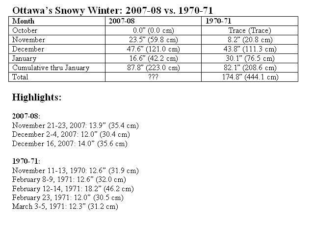
Although the January 15-February 15 period has only seen only 8 snowstorms in which 12" (30 cm) or more snow fell at Ottawa since 1938, Winter 2007-08 could be an exception. Given the prevailing pattern associated with the ongoing strong La Niña, conditions could be favorable for just such a snowfall. In fact, February 1971 saw two such snowstorms during that period. Even more impressive, the February 8-March 5, 1971 timeframe saw 4 snowstorms with 12" (30 cm) or more.

Given the latest guidance, with some allowance for climatology, my initial snowfall estimates are as follows:

Detroit: 4"-8"
Montreal: 7"-14" (17.8 cm-35.6 cm)
Ottawa: 7"-14" (17.8 cm-35.6 cm)
Toronto: 7"-14" (17.8 cm-35.6 cm)
0 likes   

combellack
Tropical Low
Tropical Low
Posts: 28
Joined: Sun Nov 11, 2007 6:11 pm

Re: 1/31-2/2/2008 Snowstorm: Initial thoughts

#2 Postby combellack » Wed Jan 30, 2008 9:32 pm

With the lack of snow this last month i am suprised that we are still ahead of 1970-1971 and i have no desire to beat that record. I wouldn't mind a good snow to cover up the plants and shelter them through the rest of the winter (snowdrops are so impatient ). Your posts are always greatly appreciated and highly informative and i thank you for them.
Mark
0 likes   

User avatar
tropicana
Category 5
Category 5
Posts: 8056
Joined: Sat Sep 27, 2003 6:48 pm
Location: Niagara Falls, Ontario, Canada
Contact:

Re: 1/31-2/2/2008 Snowstorm: Initial thoughts

#3 Postby tropicana » Wed Jan 30, 2008 10:54 pm

yes indeed, toronto does look to be in line for another pretty major snowfall... the last major snowstorm in toronto was exactly one month ago, January 1, when 9.4cm of the white stuff fell.
A number of thaws have occurred since then... so this new storm on Feb 1 seems set to bury us again.

-justin-
0 likes   

donsutherland1
S2K Analyst
S2K Analyst
Posts: 2718
Joined: Mon Sep 15, 2003 8:49 pm
Location: New York

#4 Postby donsutherland1 » Thu Jan 31, 2008 1:02 pm

The latest computer guidance continues to point to a significant snowfall across portions of the Great Lakes region into Ontario and Quebec. The potential exists for Toronto, Ottawa, and Montreal to see 6" (15.2 cm) or more fall on a single calendar day. The last time that happened in the January 15-February 15 period was as follows:

Montreal: 7.7" (19.6 cm), January 15, 2007
Ottawa: 6.3" (16.0 cm), January 26, 2006
Toronto: 6.9" (17.6 cm), January 26, 2004

There is a chance that each of the above cities could pick up 6" (15.2 cm) or more snow on the same date. The last time that happened during the January 15-February 15 timeframe was February 3, 1972 when Montreal received 7.1" (18.0 cm) of snow, Ottawa picked up 12.7" (32.3 cm), and Toronto saw 6.9" (17.5) cm.

Montreal will likely see snow transition to a period sleet, which could cut down on its total accumulations. Toronto and Ottawa might experience a shorter period of sleet. Nevertheless, all three of those Canadian cities should receive a large snowfall.

Latest Estimates:
Detroit: 5"-10"
Montreal: 6"-12" (15.2 cm-30.4 cm)
Ottawa: 7"-14" (17.8 cm-35.6 cm)
Toronto: 7"-14" (17.8 cm-35.6 cm)
0 likes   

combellack
Tropical Low
Tropical Low
Posts: 28
Joined: Sun Nov 11, 2007 6:11 pm

Re: 1/31-2/2/2008 Snowstorm: Initial thoughts

#5 Postby combellack » Sat Feb 02, 2008 2:29 pm

Good call Don, Ottawa ended up getting 32 cm out of this one.
Mark
0 likes   

User avatar
tropicana
Category 5
Category 5
Posts: 8056
Joined: Sat Sep 27, 2003 6:48 pm
Location: Niagara Falls, Ontario, Canada
Contact:

Re: 1/31-2/2/2008 Snowstorm: Initial thoughts

#6 Postby tropicana » Sun Feb 03, 2008 12:04 pm

Yes, very very good call. Pearson Airport saw 16.4cm of snow, a new Feb 1 snowfall record.
Other areas around Southern Ontario:

Markham's Buttonville Airport 17cm
Toronto Beaches area 18cm
South Whitby 28cm (just east of toronto)
Kitchener Waterloo 19cm
Cambridge 19cm

-justin-
0 likes   

donsutherland1
S2K Analyst
S2K Analyst
Posts: 2718
Joined: Mon Sep 15, 2003 8:49 pm
Location: New York

#7 Postby donsutherland1 » Mon Feb 04, 2008 11:19 am

Verification:

From: 1/30/2008 12:57 pm:
Detroit: 4"-8"; Actual: 2.8"; Error: 1.2"
Montreal: 7"-14" (17.8 cm-35.6 cm); Actual: 11.5" (29.2 cm); Within range
Ottawa: 7"-14" (17.8 cm-35.6 cm); Actual: 12.6" (31.9 cm); Within range
Toronto: 7"-14" (17.8 cm-35.6 cm); Actual: 6.5" (16.4 cm); Error: 0.5"

From: 1/31/2008 1:01 pm:
Detroit: 5"-10"; Actual: 2.8"; Error: 2.2"
Montreal: 6"-12" (15.2 cm-30.4 cm); Actual: 11.5" (29.2 cm); Within range
Ottawa: 7"-14" (17.8 cm-35.6 cm); Actual: 12.6" (31.9 cm); Within range
Toronto: 7"-14" (17.8 cm-35.6 cm); Actual: 6.5" (16.4 cm); Error: 0.5"

The potential exists for Toronto, Ottawa, and Montreal to see 6" (15.2 cm) or more fall on a single calendar day. The last time that happened in the January 15-February 15 period was as follows:

Montreal: 7.7" (19.6 cm), January 15, 2007
Ottawa: 6.3" (16.0 cm), January 26, 2006
Toronto: 6.9" (17.6 cm), January 26, 2004

There is a chance that each of the above cities could pick up 6" (15.2 cm) or more snow on the same date. The last time that happened during the January 15-February 15 timeframe was February 3, 1972 when Montreal received 7.1" (18.0 cm) of snow, Ottawa picked up 12.7" (32.3 cm), and Toronto saw 6.9" (17.5) cm.


February 1, 2008 Snowfall:
Montreal: 10.4" (26.4 cm)
Ottawa: 10.7" (27.3 cm)
Toronto: 6.5" (16.4 cm)
0 likes   


Return to “Winter Weather”

Who is online

Users browsing this forum: No registered users and 8 guests