Erin NHC Report is up (Read it on page 3)

This is the general tropical discussion area. Anyone can take their shot at predicting a storms path.

Moderator: S2k Moderators

Forum rules

The posts in this forum are NOT official forecasts and should not be used as such. They are just the opinion of the poster and may or may not be backed by sound meteorological data. They are NOT endorsed by any professional institution or STORM2K. For official information, please refer to products from the National Hurricane Center and National Weather Service.

Help Support Storm2K
Message
Author
User avatar
Chacor
Category 5
Category 5
Posts: 10229
Joined: Mon Oct 02, 2006 10:43 pm
Location: Singapore

Erin NHC Report is up (Read it on page 3)

#1 Postby Chacor » Sun Feb 03, 2008 8:57 pm

The public ATCF folder has been updated:

Posted as of Jan 31, 2008
-------------------------
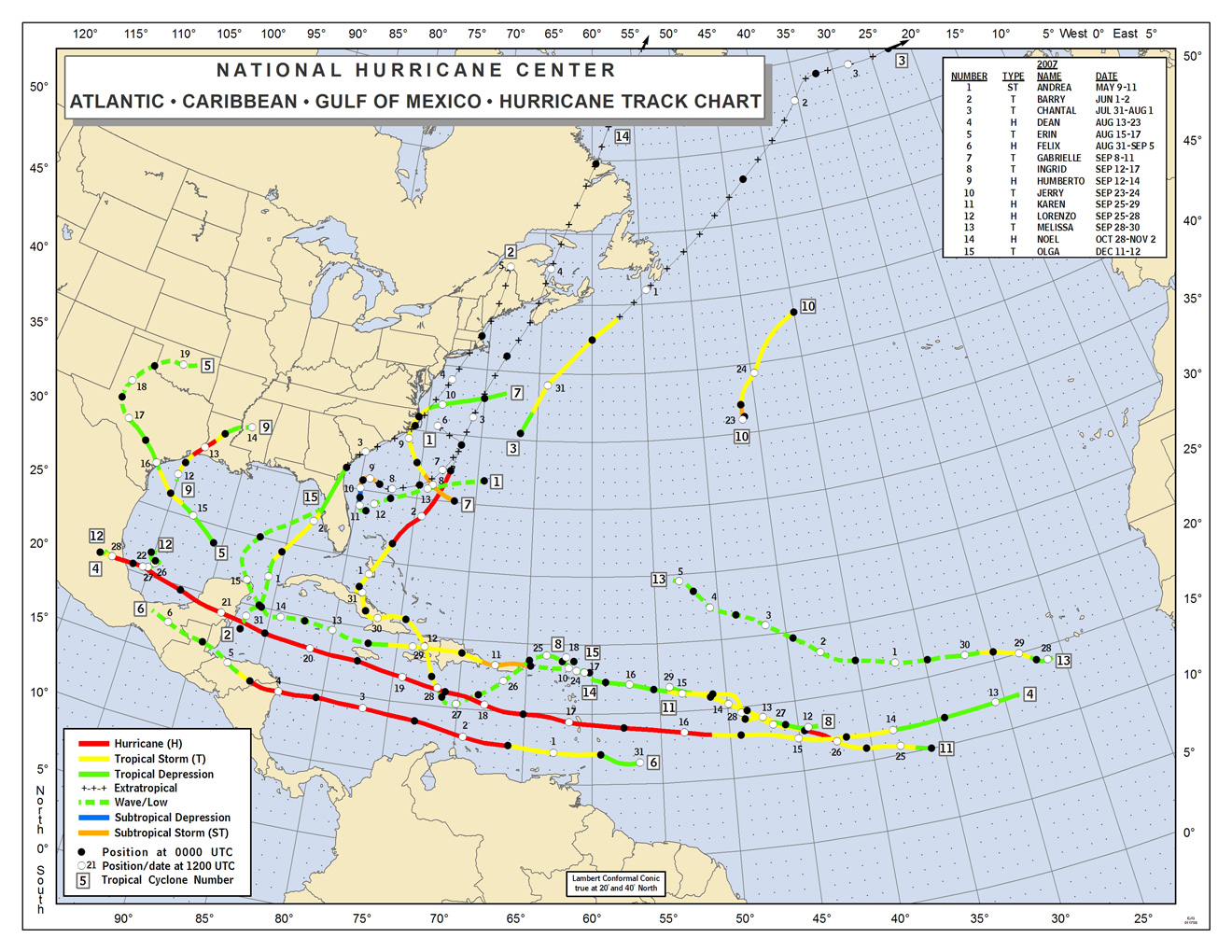
Final '07 season best track, guidance and fix information has been posted. Additional
guidance (OCD5 and BCD5) has been merged into the the A-decks. Data is avalaible in the
real-time data sub-directories and is also in compressed form in the archived area.

The Erin file: ftp://ftp.tpc.ncep.noaa.gov/atcf/btk/bal052007.dat

Code: Select all

AL, 05, 2007081500,   , BEST,   0, 237N,  907W,  25, 1006, TD,   0,    ,    0,    0,    0,    0, 1010,  175,  60,  35,   0,   L,   0,    ,   0,   0,       FIVE, M,
AL, 05, 2007081506,   , BEST,   0, 245N,  918W,  25, 1006, TD,   0,    ,    0,    0,    0,    0, 1010,  175,  60,  35,   0,   L,   0,    ,   0,   0,       FIVE, M,
AL, 05, 2007081512,   , BEST,   0, 252N,  929W,  30, 1005, TD,   0,    ,    0,    0,    0,    0, 1010,  175,  60,  35,   0,   L,   0,    ,   0,   0,       FIVE, M,
AL, 05, 2007081518,   , BEST,   0, 258N,  940W,  35, 1004, TS,  34, NEQ,   60,    0,    0,    0, 1010,  175,  60,  45,   0,   L,   0,    ,   0,   0,       ERIN, M,
AL, 05, 2007081600,   , BEST,   0, 263N,  952W,  35, 1003, TS,  34, NEQ,   75,    0,    0,    0, 1010,  150,  60,  45,   0,   L,   0,    ,   0,   0,       ERIN, M,
AL, 05, 2007081606,   , BEST,   0, 272N,  962W,  35, 1005, TS,  34, NEQ,   75,    0,    0,    0, 1010,  150,  60,  45,   0,   L,   0,    ,   0,   0,       ERIN, M,
AL, 05, 2007081612,   , BEST,   0, 281N,  971W,  30, 1006, TD,   0,    ,    0,    0,    0,    0, 1010,  150,  60,  40,   0,   L,   0,    ,   0,   0,       ERIN, M,
AL, 05, 2007081618,   , BEST,   0, 288N,  978W,  25, 1006, TD,   0,    ,    0,    0,    0,    0,
AL, 05, 2007081700,   , BEST,   0, 294N,  986W,  25, 1006, TD,   0,    ,    0,    0,    0,    0,
AL, 05, 2007081706,   , BEST,   0, 300N,  995W,  25, 1007, TD,   0,    ,    0,    0,    0,    0,
AL, 05, 2007081712,   , BEST,   0, 305N, 1006W,  20, 1008, LO,   0,    ,    0,    0,    0,    0,
AL, 05, 2007081718,   , BEST,   0, 311N, 1014W,  20, 1008, LO,   0,    ,    0,    0,    0,    0,
AL, 05, 2007081800,   , BEST,   0, 318N, 1018W,  20, 1008, LO,   0,    ,    0,    0,    0,    0,
AL, 05, 2007081806,   , BEST,   0, 325N, 1018W,  20, 1008, LO,   0,    ,    0,    0,    0,    0,
AL, 05, 2007081812,   , BEST,   0, 332N, 1015W,  20, 1008, LO,   0,    ,    0,    0,    0,    0,
AL, 05, 2007081818,   , BEST,   0, 340N, 1010W,  20, 1007, LO,   0,    ,    0,    0,    0,    0,
AL, 05, 2007081900,   , BEST,   0, 348N, 1001W,  25, 1004, LO,   0,    ,    0,    0,    0,    0,    <-----
AL, 05, 2007081906,   , BEST,   0, 356N,  988W,  50,  995, LO,  34, NEQ,   45,   45,    0,    0,    <-----
AL, 05, 2007081906,   , BEST,   0, 356N,  988W,  50,  995, LO,  50, NEQ,   15,    0,    0,    0,    <-----
AL, 05, 2007081912,   , BEST,   0, 356N,  977W,  35, 1002, LO,  34, NEQ,    0,   10,    0,    0,    <-----
AL, 05, 2007081918,   , BEST,   0, 359N,  965W,  20, 1007, LO,   0,    ,    0,    0,    0,    0,


The BT brings Erin to a 50 kt LOW inland, it appears it will not be upgraded to a tropical cyclone overland.
0 likes   

Coredesat

#2 Postby Coredesat » Sun Feb 03, 2008 9:38 pm

The BT seems to be written strategically to make Erin a 20 kt remnant low very quickly after landfall, so they might be trying to dodge the issue of what Erin was over Oklahoma.
0 likes   

Matt-hurricanewatcher

Re: Final Best-Track: Erin 50 kts LOW inland

#3 Postby Matt-hurricanewatcher » Sun Feb 03, 2008 10:11 pm

It would not suprize me at all if they did nothing with it, but it was a interesting event none the less.
0 likes   

User avatar
Cyclenall
Category 5
Category 5
Posts: 6667
Joined: Thu Jun 08, 2006 10:01 pm
Location: Ontario, Canada

#4 Postby Cyclenall » Sun Feb 03, 2008 10:12 pm

I hope this issue isn't brushed aside and ignored.
0 likes   

Derek Ortt

#5 Postby Derek Ortt » Sun Feb 03, 2008 11:32 pm

I've seen it

if it is not extra-tropical, a 50KT low makes no sense at all from a scientific vantagepoint
0 likes   

CrazyC83
Professional-Met
Professional-Met
Posts: 34005
Joined: Tue Mar 07, 2006 11:57 pm
Location: Deep South, for the first time!

#6 Postby CrazyC83 » Sun Feb 03, 2008 11:39 pm

It was definitely not a "tropical low". That makes the least sense of any of the conclusions...it had a clearly-defined circulation. It was definitely a cyclone, although it can be debated if it was extratropical, subtropical or tropical. (IMO it was subtropical)
0 likes   

User avatar
wxman57
Moderator-Pro Met
Moderator-Pro Met
Posts: 22989
Age: 67
Joined: Sat Jun 21, 2003 8:06 pm
Location: Houston, TX (southwest)

Re:

#7 Postby wxman57 » Mon Feb 04, 2008 1:41 pm

Coredesat wrote:The BT seems to be written strategically to make Erin a 20 kt remnant low very quickly after landfall, so they might be trying to dodge the issue of what Erin was over Oklahoma.


Erin was a 20kt remnant low very shortly after landfall. It was a very poorly-organized tropical storm with perhaps a tiny area of 35kt winds in a few squalls over water. Max winds on the coast were probably in the 20-25 kt range at landfall (1 min sustained). The question is, what happened to the remnant circulation as it moved northward and interacted with a mid-latitude feature? I don't think one can make a good argument that we saw tropical storm development over Oklahoma. It appeared to be some type of hybrid subtropical storm. The discussion part of the report should be out soon. Let's see what the NHC has to say about Erin's stronger winds well inland.
0 likes   

User avatar
brunota2003
S2K Supporter
S2K Supporter
Posts: 9476
Age: 34
Joined: Sat Jul 30, 2005 9:56 pm
Location: Stanton, KY...formerly Havelock, NC
Contact:

#8 Postby brunota2003 » Mon Feb 04, 2008 2:25 pm

Or perhaps, like the rest of us, they just dont know what the heck that thing was?
0 likes   

Squarethecircle
Category 5
Category 5
Posts: 2165
Joined: Fri Oct 19, 2007 4:00 pm
Location: Fairfax, VA

#9 Postby Squarethecircle » Mon Feb 04, 2008 2:27 pm

:uarrow: Quite likely.
0 likes   

Cyclone1
Category 5
Category 5
Posts: 2739
Age: 33
Joined: Tue Jun 12, 2007 12:03 pm
Location: Florida

#10 Postby Cyclone1 » Mon Feb 04, 2008 2:31 pm

50kt LOW?

Isn't that the same as saying like... 160mph Category 3?
0 likes   

Squarethecircle
Category 5
Category 5
Posts: 2165
Joined: Fri Oct 19, 2007 4:00 pm
Location: Fairfax, VA

#11 Postby Squarethecircle » Mon Feb 04, 2008 2:43 pm

:uarrow: Not really. Lows can be any intensity (in theory). As previously stated, it seems nobody really knows precisely what it was.
0 likes   

User avatar
Chacor
Category 5
Category 5
Posts: 10229
Joined: Mon Oct 02, 2006 10:43 pm
Location: Singapore

#12 Postby Chacor » Mon Feb 11, 2008 8:52 pm

Image

They've issued this before the Erin TCR.
0 likes   

User avatar
HURAKAN
Professional-Met
Professional-Met
Posts: 46086
Age: 38
Joined: Thu May 20, 2004 4:34 pm
Location: Key West, FL
Contact:

#13 Postby HURAKAN » Mon Feb 11, 2008 9:19 pm

I was expecting a least one more system to be addead, but it seems that won't happen. Interesting.
0 likes   

Derek Ortt

#14 Postby Derek Ortt » Mon Feb 11, 2008 9:38 pm

I do not understand that one? Is it ET or is it not. If not, it is a storm by definition, not a mere low
0 likes   

caneflyer
Tropical Storm
Tropical Storm
Posts: 128
Joined: Wed Sep 24, 2003 7:25 pm

Re:

#15 Postby caneflyer » Mon Feb 11, 2008 10:07 pm

Derek Ortt wrote:I do not understand that one? Is it ET or is it not. If not, it is a storm by definition, not a mere low


Who says the only categories of lows are extratropical and tropical? Tropical cyclones that lose their convection over cold water in the east Pacific become (remnant) lows. They're no longer tropical cyclones, but there's nothing extratropical about them either.

Clearly, the remnants of Erin are not considered to be a tropical cyclone by NHC, perhaps because the convective structure/organization over Oklahoma was relatively short lived (indicating it was more a mesoscale phenomenon than a synoptic scale cyclone), perhaps because the energetics weren't typical of a tropical cyclone (i.e., no sensible/latent heat transports from underlying surface), etc. And without frontal structures, they probably didn't consider it ET. So it's a low that qualifies neither as a tropical cyclone nor an extratropical cyclone. Nothing wrong with that, really.
0 likes   

Coredesat

Re: Re:

#16 Postby Coredesat » Mon Feb 11, 2008 10:30 pm

caneflyer wrote:So it's a low that qualifies neither as a tropical cyclone nor an extratropical cyclone. Nothing wrong with that, really.


By default, a closed low pressure area that is not tropical, subtropical, or polar is extratropical ("non-tropical"). "Remnant low" is used to refer to a system that has no longer has enough convection to be considered a tropical cyclone. Erin was most definitely not a remnant low. My theory is that the NHC thinks it was a mesoscale feature, like what you suggest.
0 likes   

caneflyer
Tropical Storm
Tropical Storm
Posts: 128
Joined: Wed Sep 24, 2003 7:25 pm

Re: Re:

#17 Postby caneflyer » Mon Feb 11, 2008 10:46 pm

Coredesat wrote:
caneflyer wrote:So it's a low that qualifies neither as a tropical cyclone nor an extratropical cyclone. Nothing wrong with that, really.


By default, a closed low pressure area that is not tropical, subtropical, or polar is extratropical ("non-tropical").


No, I'd suggest that there really is no such thing as a default. At least, nature is not the least bit interested in man's attempts at putting a spectrum of possibilities into a small number of categories.

A "low" is a generic term that simply means an area of closed low pressure. If a low meets the definition of some particular class of low, then great. But there is no rule that says every low has to be either a tropical cyclone, subtropical cyclone, polar low, or extratropical cyclone.

Not to put too fine a point on it, but into which category (tropical, subtropical, polar, or extratropical) would you place a tornado? Or a monsoon depression? (This last one is tropical, to be sure, but it's not a tropical cyclone.)
0 likes   

Derek Ortt

#18 Postby Derek Ortt » Tue Feb 12, 2008 12:33 am

I will wait for the TCR. However, looking at the synoptic pattern and structure, it looks similar to Allison when it intensified quickly over central Mississippi in 2001. It was classified as an STS
0 likes   

HurricaneRobert
Category 3
Category 3
Posts: 812
Joined: Fri May 18, 2007 9:31 pm

Re: Final Best-Track: Erin 50 kts LOW inland

#19 Postby HurricaneRobert » Tue Feb 12, 2008 11:49 am

I don't think that's the "final" say since its been almost two weeks and the TCR is still not out.
0 likes   

Ed Mahmoud

Re: Final Best-Track: Erin 50 kts LOW inland

#20 Postby Ed Mahmoud » Tue Feb 12, 2008 12:06 pm

Well, as soon as an inland tropical cyclone drops below tropical storm strength, NHC passes it to HPC and at least by bureaucratic definition, unless it approaches the coast again, its a remnant low, even though I believe HPC continues to refer to them sometimes as tropical depressions.

If I understand the system correctly.


Of course, tropical rainstorm Allison, whose name has been retired, did all (well, most) of the big raining on Texas after it had been handed off to HPC, so I almost wonder why they retired the name. It wasn't technically a named system anymore, was it?
0 likes   


Return to “Talkin' Tropics”

Who is online

Users browsing this forum: Google [Bot] and 25 guests