February 5-6: Super Tuesday Outbreak... 57 dead

U.S. & Caribbean Weather Discussions and Severe Weather Events

Moderator: S2k Moderators

Forum rules

The posts in this forum are NOT official forecast and should not be used as such. They are just the opinion of the poster and may or may not be backed by sound meteorological data. They are NOT endorsed by any professional institution or STORM2K.

Help Support Storm2K
Message
Author
User avatar
HarlequinBoy
Category 5
Category 5
Posts: 1400
Age: 34
Joined: Wed Nov 29, 2006 1:57 am
Location: Memphis

Re: Re:

#101 Postby HarlequinBoy » Mon Feb 04, 2008 10:27 pm

Ed Mahmoud wrote:
HarlequinBoy wrote:If the dryline keeps moving west I think this might be a big outbreak for Arkansas.

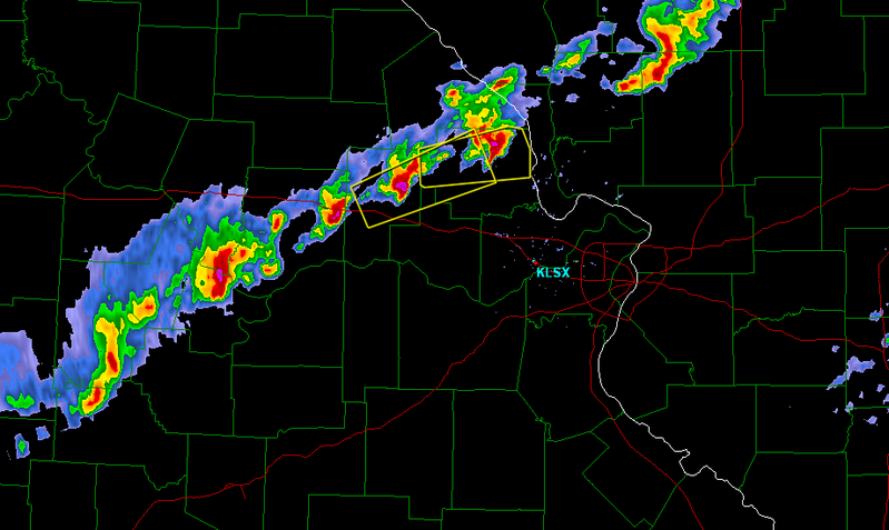
SVR Calhoun, Greene, and Pike Counties in western Illinois.
SVR Hickory, Benton, and Camden Counties in central Missouri.


Discussions from Texas NWSFO earlier had the dry line retreating Westward in the overnight hours before surging forward again tomorrow.


Ahh, my bad. I thought it had retreated back farther and faster than forecast.
0 likes   

User avatar
HarlequinBoy
Category 5
Category 5
Posts: 1400
Age: 34
Joined: Wed Nov 29, 2006 1:57 am
Location: Memphis

#102 Postby HarlequinBoy » Mon Feb 04, 2008 10:32 pm

SVR Lincoln, Montgomery, and Warren Counties in Missouri until 1015 PM.
0 likes   

RL3AO
Moderator-Pro Met
Moderator-Pro Met
Posts: 16308
Joined: Thu Jun 14, 2007 10:03 pm
Location: NC

#103 Postby RL3AO » Mon Feb 04, 2008 10:37 pm

Nice little line.

Image
0 likes   

User avatar
HarlequinBoy
Category 5
Category 5
Posts: 1400
Age: 34
Joined: Wed Nov 29, 2006 1:57 am
Location: Memphis

#104 Postby HarlequinBoy » Mon Feb 04, 2008 10:40 pm

Image
0 likes   

Ed Mahmoud

Re: Potential Mardi Gras Outbreak - February 4-5

#105 Postby Ed Mahmoud » Mon Feb 04, 2008 10:42 pm

Don't know what it means, but actual 0Z Fort Worth sounding is a touch more unstable and a little less inhibition that 0Z WRF model at tau zero

Image

versus

Image


Looking at the actual sounding at CRP, from the general direction Houston's 800 to 900 mb winds are coming from, pronounced CAP, although the actual sounding is very slightly more unstable and slightly less CINH than the WRF forecast sounding.
Image


I like to check model soundings/forecasts vs actual at time zero, and during the NYC non-snow about a week back, the WRF was 2 to 3º Celcius to cool with surface temps, leading me to suspect Bastardi would be right in predicting the NYC area WSW would bust.

New WRF suggests Houston remains capped.

Hard to argue too much, although the model has a touch too much inhibition, the warm layer does look pretty steep. Based on forecast precip, best action looks like Arkansas, SE Missouri, Tennessee, Northern Mississippi and Southwest Kentucky.

Most Unstable CAPE in excess of 750 J/Kg, some places in excess of 1000 J/Kg, 50 to 70 knots deep layer shear, strong directional shear between the surface and 700 mb, looks interesting.

Image

Looking at forecast skew-Ts, Northeast Arkansas looks to have the best combination of instability and shear, with just a hint of a cap to keep everything in check until conditions are prime.

Image
0 likes   

CrazyC83
Professional-Met
Professional-Met
Posts: 34002
Joined: Tue Mar 07, 2006 11:57 pm
Location: Deep South, for the first time!

#106 Postby CrazyC83 » Mon Feb 04, 2008 10:48 pm

Looks like some small bow echoes trying to form...
0 likes   

JonathanBelles
Professional-Met
Professional-Met
Posts: 11430
Age: 35
Joined: Sat Dec 24, 2005 9:00 pm
Location: School: Florida State University (Tallahassee, FL) Home: St. Petersburg, Florida
Contact:

#107 Postby JonathanBelles » Mon Feb 04, 2008 10:50 pm

Ed: Can you explain your last post in common person terms?

thanks in advance.
0 likes   

RL3AO
Moderator-Pro Met
Moderator-Pro Met
Posts: 16308
Joined: Thu Jun 14, 2007 10:03 pm
Location: NC

Re:

#108 Postby RL3AO » Mon Feb 04, 2008 10:53 pm

CrazyC83 wrote:Looks like some small bow echoes trying to form...


They kinda do.
0 likes   

Ed Mahmoud

Re:

#109 Postby Ed Mahmoud » Mon Feb 04, 2008 11:00 pm

fact789 wrote:Ed: Can you explain your last post in common person terms?

thanks in advance.


I'm not a professional (well, I'm a petroleum engineer, but that is a different kettle of fish). Although, while I did take the FE exam (aka, The EIT), I have not taken the P&P exam of the Texas Board of Professional Engineers, and therefore can't legally call myself a 'professional engineer'.

1) Houston (where I live near) may miss out, warm, dry air off the highlands of Mexico may 'cap' surface parcels from rising. Cap may not break at all, or as a skinny line of storms right along the front. What the 0Z WRF is suggesting, anyway.

2)Jonesboro/Memphis area has a very interesting afternoon ahead. Reasonable instability, ballpark 1000 Joules/Kg, which would usually be considered low, later in the season, but enough with 50 to 70 knot deep shear, and screaming helicities, for tornadoes.
0 likes   

Ed Mahmoud

Re: Potential Mardi Gras Outbreak - February 4-5

#110 Postby Ed Mahmoud » Mon Feb 04, 2008 11:05 pm

The cell just North of Jefferson City looks like a hailer. I expect a warning any time.


No idea what FFG is, but with the cells basically training, expect some flooding soon.
0 likes   

User avatar
HarlequinBoy
Category 5
Category 5
Posts: 1400
Age: 34
Joined: Wed Nov 29, 2006 1:57 am
Location: Memphis

#111 Postby HarlequinBoy » Mon Feb 04, 2008 11:11 pm

SVR Callaway and Osage Counties in Central Missouri until 1045 PM.
SVR northern Gasconade, western Lincoln, Montgomery, and Warren Counties in East Central Missouri until 1100 PM.
Last edited by HarlequinBoy on Mon Feb 04, 2008 11:21 pm, edited 1 time in total.
0 likes   

User avatar
HarlequinBoy
Category 5
Category 5
Posts: 1400
Age: 34
Joined: Wed Nov 29, 2006 1:57 am
Location: Memphis

Re: Re:

#112 Postby HarlequinBoy » Mon Feb 04, 2008 11:12 pm

Ed Mahmoud wrote:
fact789 wrote:Ed: Can you explain your last post in common person terms?

thanks in advance.


I'm not a professional (well, I'm a petroleum engineer, but that is a different kettle of fish). Although, while I did take the FE exam (aka, The EIT), I have not taken the P&P exam of the Texas Board of Professional Engineers, and therefore can't legally call myself a 'professional engineer'.

1) Houston (where I live near) may miss out, warm, dry air off the highlands of Mexico may 'cap' surface parcels from rising. Cap may not break at all, or as a skinny line of storms right along the front. What the 0Z WRF is suggesting, anyway.

2)Jonesboro/Memphis area has a very interesting afternoon ahead. Reasonable instability, ballpark 1000 Joules/Kg, which would usually be considered low, later in the season, but enough with 50 to 70 knot deep shear, and screaming helicities, for tornadoes.


Thanks for your posts. They're always a good read.
0 likes   

User avatar
HarlequinBoy
Category 5
Category 5
Posts: 1400
Age: 34
Joined: Wed Nov 29, 2006 1:57 am
Location: Memphis

#113 Postby HarlequinBoy » Mon Feb 04, 2008 11:19 pm

Jackson issued an evening update with a good discussion.. posted relevant snippets.

CONCERNING SEVERE...MODELS CONTINUE TO POINT AT A SIGNIFICANT SEVERE
WEATHER OUTBREAK TOMORROW AND TOMORROW NIGHT. EXPECT ACTIVITY TO GET
GOING IN THE DELTA BY LATE MORNING AND THEN OVER THE REMAINDER OF
THE AREA LATER IN THE AFTERNOON AS THE CAP ERODES.


.SHORT TERM...ALL PARAMETERS POINTING TO WIDESPREAD SEVERE WEATHER
OUTBREAK TOMORROW AND TOMORROW NIGHT.
WILL SEE A 50-60 KT JET AND
332 850 MB THETAE RIDGE NOSING NWS NEAR THE RIVER LATE TUESDAY
MORNING WITH 0-1KM HELICITY VALUES OVER 200 NEAR THE RIVER AND WWD.
MLCAPES INCREASE NEAR 1000 OVER WRN ZONES BY 18Z WITH VGP NUMBERS
AROUND 0.35. THE COLD FRONT WILL EXTEND FROM NW AR INTO NE TX BY 18Z
BUT SUPERCELLS WILL BE POSSIBLE WELL AHEAD OF THE LINE ASSOCIATED
WITH THE BOUNDARY. THIS WILL POSSIBLY BE ENHANCED BY A WEAK
SHORTWAVE THAT THE MODELS LIFT INTO THE FORECAST AREA FROM THE SW
TUESDAY MORNING. SPC HAS ISSUED A MODERATE RISK FOR OUR ENTIRE AREA
FOR TUESDAY INTO TUESDAY NIGHT. WITH SUCH INTENSE SHEAR ACROSS THE
REGION...EXPECT THE PRIMARY SEVERE WEATHER RISK TO BE DAMAGING WIND
AND TORNADOES ALTHOUGH DEEP CONVECTION TOMORROW WILL DEFINITELY
SUPPORT LARGE HAIL
. WILL SEE A SQUALL LINE GEL AS THE FRONT GETS
CLOSER TOMORROW. LOOSE ESTIMATES PUSH THE THE SQUALL LINE INTO WRN
ZONES LATE TOMORROW AFTERNOON AND SWEEP IT ACROSS THE REMAINDER OF
THE REGION TUESDAY NIGHT. WILL SEE SEVERE STORMS SWEEP EAST OF
MISSISSIPPI BY SUNRISE WEDNESDAY.
0 likes   

RL3AO
Moderator-Pro Met
Moderator-Pro Met
Posts: 16308
Joined: Thu Jun 14, 2007 10:03 pm
Location: NC

#114 Postby RL3AO » Mon Feb 04, 2008 11:48 pm

Check this out.

Severe thunderstorm watch and a winter storm watch for the same county.

http://forecast.weather.gov/MapClick.ph ... &map.y=131
0 likes   

CrazyC83
Professional-Met
Professional-Met
Posts: 34002
Joined: Tue Mar 07, 2006 11:57 pm
Location: Deep South, for the first time!

#115 Postby CrazyC83 » Tue Feb 05, 2008 12:09 am

Might want to change the dates to February 4-6, as it should continue well past midnight tomorrow night.

Whether they go HIGH or not tomorrow, a long day ahead of us for sure. At the very least it should be a strongly-worded MDT.
0 likes   

CrazyC83
Professional-Met
Professional-Met
Posts: 34002
Joined: Tue Mar 07, 2006 11:57 pm
Location: Deep South, for the first time!

#116 Postby CrazyC83 » Tue Feb 05, 2008 12:09 am

I'd be wary of overnight supercells that may break out of the line...
0 likes   

wbug1

Re: Potential Mardi Gras Outbreak - February 4-5

#117 Postby wbug1 » Tue Feb 05, 2008 12:30 am

With that low ground temps just behind the cold front, the potential for hail seems large. Admittedly, I would need to know the temps higher up, not just the ground level temps. Possible snowsqualls/sleet/freezing rain wed night after behind that front? Flashfreeze warning wed night? weather.com shows ground temps at or under 32 F in several areas just west and north of the MDT wed night.

In addition to the severe thunderstorm hail, wind and tornado threat, there seems to be a threat of heavy snow, sleet or freezing rain with precip freezing up wed night on the ground just west and north of the MDT area. The SPC has flood and winter weather watch up, but I don't see freezing rain or flash freeze warnings up. Not sure if flash freeze warning exists in US, it does in Canada.

That's one of the worst forecasts (short of an incoming cat 3 hurricane) for weather I've ever seen.
Last edited by wbug1 on Tue Feb 05, 2008 12:47 am, edited 1 time in total.
0 likes   

User avatar
HarlequinBoy
Category 5
Category 5
Posts: 1400
Age: 34
Joined: Wed Nov 29, 2006 1:57 am
Location: Memphis

Re:

#118 Postby HarlequinBoy » Tue Feb 05, 2008 12:44 am

CrazyC83 wrote:Might want to change the dates to February 4-6, as it should continue well past midnight tomorrow night.

Whether they go HIGH or not tomorrow, a long day ahead of us for sure. At the very least it should be a strongly-worded MDT.


Changed. I'm thinking they could go HIGH, the forecast parameters support it, but they may go MDT if they want to be a bit conservative and not overhype. Either way, I think people around here are fairly informed. The media definitely mentioned the threat tonight.


Also, severe thunderstorm moving through northern parts of St. Louis.
0 likes   

RL3AO
Moderator-Pro Met
Moderator-Pro Met
Posts: 16308
Joined: Thu Jun 14, 2007 10:03 pm
Location: NC

#119 Postby RL3AO » Tue Feb 05, 2008 12:59 am

646
ACUS01 KWNS 050558
SWODY1
SPC AC 050555

DAY 1 CONVECTIVE OUTLOOK
NWS STORM PREDICTION CENTER NORMAN OK
1155 PM CST MON FEB 04 2008

VALID 051200Z - 061200Z

..THERE IS A MDT RISK OF SVR TSTMS OVER MUCH OF AR
FAR NERN
TX...NRN LA...CNTRL AND NRN MS...WRN TN...SERN MO...SRN IL AND FAR
SWRN IND...

...THERE IS A SLGT RISK OF SVR TSTMS FROM THE SRN LOW PLAINS AND
LOWER MS VALLEY NEWD INTO THE OH VALLEY...

..SYNOPSIS

STRONG...UPPER TROUGH CURRENTLY EVOLVING OVER THE FOUR CORNERS
REGION WILL LIFT NEWD TODAY ACROSS THE SRN PLAINS INTO MID MS VALLEY
AS MID AND UPPER-LEVEL JET STREAKS INTENSIFY IN THE DOWNSTREAM
POSITION FROM THE ARKLATEX INTO LOWER OH VALLEY. IN THE LOW
LEVELS...SURFACE LOW ALONG THE RED RIVER OVER S-CNTRL OK/N-CNTRL TX
IS FORECAST TO DEEPEN SLIGHTLY WHILE DEVELOPING NEWD TO N-CNTRL AR
BY 06/00Z AND INTO SRN OH BY THE END OF THE PERIOD. ATTENDANT DRY
LINE INITIALLY FROM THE LOW SWD INTO CNTRL TX IS EXPECTED TO EVOLVE
INTO A PACIFIC COLD FRONT WHILE PROGRESSING EWD THROUGH THE
ARKLATEX. MEANWHILE...A STRONGER COLD FRONT WILL SURGE SEWD FROM
CNTRL OK AND WRN TX...EVENTUALLY OVERTAKING PACIFIC COLD FRONT NEAR
THE MS RIVER TONIGHT.

..SRN LOW PLAINS AND LOWER MS VALLEY NEWD INTO THE OH VALLEY

05/00Z OBSERVED SOUNDINGS FROM THE TX COAST INTO LOWER MS VALLEY
INDICATED THE PRESENCE OF A RELATIVELY STRONG CAP ATOP MODEST
BOUNDARY LAYER MOISTURE WITH MEAN MIXING RATIOS OF 10-13 G/KG.
A BROAD...SWLY LLJ ESTABLISHED FROM THE NWRN GULF OF MEXICO INTO THE
LOWER GREAT LAKES WILL UNDERGO CONSIDERABLE STRENGTHENING
TODAY...SUPPORTING A FURTHER INCREASE IN BOUNDARY LAYER MOISTURE
CONTENT. SURFACE DEWPOINTS IN THE LOW TO MID 60S WILL BE COMMON
ACROSS THE MID SOUTH WITH UPPER 60S TO AROUND 70 F ALONG THE GULF
COAST. THIS MOISTURE COUPLED WITH MIDLEVEL LAPSE RATES OF 7-7.5
C/KM SHOULD SUPPORT A MODERATELY UNSTABLE AIR MASS /MLCAPES OF
AROUND 1000 J PER KG/ BY AFTERNOON FROM SERN OK AND ERN TX EWD/NEWD
ACROSS AR...LA AND MS. INSTABILITY WILL TEND TO DECREASE WITH NEWD
EXTENT ACROSS THE OH VALLEY.

TSTMS ARE EXPECTED TO BE ONGOING AT THE ONSET OF THE PERIOD ALONG
FRONT FROM OH/IND/IL SWWD INTO SRN MO...WITH ONGOING OR DEVELOPING
STORMS OVER PARTS OF CNTRL/ERN OK INTO N-CNTRL/CNTRL TX. LATEST
SHORT TERM MODEL GUIDANCE SUGGESTS THAT THE MOST INTENSE STORMS WILL
LIKELY OCCUR FROM VICINITY OF SURFACE LOW SWD ALONG PACIFIC COLD
FRONT AS STRONG...DEEP LAYER FORCING FOR ASCENT OVERSPREADS
DESTABILIZING WARM SECTOR.

SOME UNCERTAINTIES IN THIS CONVECTIVE EVOLUTION REVOLVE AROUND: 1)
WHETHER STORMS WILL REMAIN CONFINED TO ALONG THE FRONT AND 2)
PRIMARY CONVECTIVE MODE. ETAKF SOUNDINGS WHICH APPEAR TO BETTER
RESOLVE THE OBSERVED CAP TEND TO LIMIT STORMS TO ALONG THE FRONT.
ONE POTENTIAL CAVEAT IS A RATHER WELL-DEFINED SHORT WAVE TROUGH
EMBEDDED IN SUB-TROPICAL MOISTURE PLUME NEAR THE LOWER RIO GRANDE
VALLEY AS OF 05/0530Z. THIS SYSTEM WILL PRECEED THE PRIMARY UPPER
TROUGH...AND IT IS POSSIBLE THAT FORCING FOR ASCENT ASSOCIATED WITH
THIS FEATURE COULD INITIATE MORE DISCRETE STORMS DOWNSTREAM FROM THE
MAIN CONVECTIVE DEVELOPMENT ANTICIPATED ALONG THE FRONT.

FORECAST SOUNDINGS INDICATE THAT THE MODERATE RISK AREA WARM SECTOR
WILL BE STRONGLY SHEARED WITH EFFECTIVE SRH VALUES OF 250-350 M2/S2
AND EFFECTIVE BULK SHEARS OF 50-60 KT. ANY MORE DISCRETE STORMS
THAT CAN DEVELOP WILL BE CAPABLE OF POTENTIALLY STRONG AND
LONG-TRACK TORNADOES. LARGE HAIL WILL ALSO BE POSSIBLE...AS WILL
CORRIDORS OF DAMAGING WINDS. THE WIND THREAT MAY TEND TO INCREASE
TONIGHT OVER THE LOWER OH AND LOWER MS VALLEYS AND POINTS E AS
STORMS GROW UPSCALE INTO A QUASI-LINEAR MCS. HIGH RESOLUTION MODEL
DATA SETS SUGGEST THAT THE CHARACTER OF THIS MCS COULD BE
SHORT...BROKEN LINES OF SUPERCELLS AND/OR BOWS WITH A CONTINUED
THREAT OF STRONG TORNADOES.

UNCERTAINTIES IN THE CONVECTIVE EVOLUTION GIVEN THE
ABOVEMENTIONED...LEAD SHORT WAVE TROUGH AND PRIMARY CONVECTIVE MODE
ARE GREAT ENOUGH SUCH THAT A CATEGORICAL MODERATE RISK WILL BE
MAINTAINED. AN UPGRADE TO HIGH RISK MAY BECOME NECESSARY ONCE
THESE DETAILS BECOME MORE CLEAR.


..MEAD.. 02/05/2008
0 likes   

Coredesat

#120 Postby Coredesat » Tue Feb 05, 2008 1:03 am

Based on what I've seen, I'd expect them to upgrade to high risk later this morning.
0 likes   


Return to “USA & Caribbean Weather”

Who is online

Users browsing this forum: HurricaneBelle and 18 guests