
I decided to create a thread to post severe weather stuff that doesn't have to do with a major organized outbreak. Weather you want to post a warning or a watch. I figured it might be nice to have a place to post SVR and TOR warnings outside of a major outbreak.
*titled edited by southerngale to change the day from Sunday to Saturday as that is the correct day for possible severe weather in SE Texas
2008 Severe Weather Thread
Moderator: S2k Moderators
Forum rules

The posts in this forum are NOT official forecast and should not be used as such. They are just the opinion of the poster and may or may not be backed by sound meteorological data. They are NOT endorsed by any professional institution or STORM2K.
2008 Severe Weather Thread
Last edited by RL3AO on Wed May 07, 2008 10:59 am, edited 13 times in total.
0 likes
Re: 2008 Severe Weather thread
30% hatched day 3
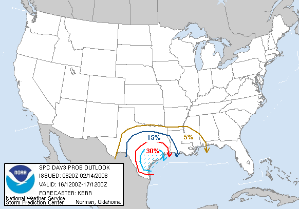
...SOUTHERN PLAINS/LOWER MISSISSIPPI VALLEY...
PERHAPS THE BIGGEST SOURCE OF FORECAST UNCERTAINTY FOR THIS PERIOD
CONCERNS JUST HOW FAST THE SHALLOW COLD SURFACE BASED AIR MASS
MODIFIES ACROSS CENTRAL TEXAS INTO TEXAS GULF COASTAL AREAS...IN THE
WAKE OF THE ANTICIPATED COLD INTRUSION LATE THIS WEEK. ASIDE FROM
BOUNDARY LAYER DESTABILIZATION ISSUES...THIS WILL IMPACT THE
STRENGTH/LOCATION OF SURFACE CYCLOGENESIS...WHICH SHOULD INITIATE
WITH THE APPROACH OF THE UPPER SYSTEM. IT CURRENTLY SEEMS A BIT
MORE PROBABLE THAT THIS PROCESS WILL BE WEAKER/SLOWER AND ALONG A
BAROCLINIC ZONE IN CLOSER PROXIMITY TO COASTAL AREAS...THAN
CURRENTLY INDICATED BY EITHER THE ECMWF OR GFS.
REGARDLESS...THIS SHOULD ONLY IMPACT THE TORNADO POTENTIAL. IF NOT
NEAR THE SURFACE...JUST ABOVE...THERMODYNAMIC PROFILES ACROSS MUCH
OF TEXAS ARE EXPECTED TO BECOME CONVECTIVELY UNSTABLE. AND...A
LOADED GUN TYPE STRUCTURE SHOULD EVOLVE...PARTICULARLY ACROSS PARTS
OF SOUTH CENTRAL INTO SOUTHEAST TEXAS...AS A SOUTHERLY LOW-LEVEL JET
CONTINUES TO STRENGTHEN OFF THE WESTERN GULF OF MEXICO...BENEATH AN
ELEVATED MIXED LAYER. BY LATE SATURDAY AFTERNOON...VERY LARGE
CLOCKWISE CURVED LOW-LEVEL HODOGRAPHS ARE FORECAST TO EVOLVE BENEATH
50+ KT SOUTHERLY 850 FLOW...WHILE DEEP LAYER SHEAR INTENSIFIES AS A
STRONG SOUTHWESTERLY UPPER JET NOSES THROUGH THE LOWER RIO GRANDE
VALLEY.
THIS ENVIRONMENT WILL BE FAVORABLE FOR SUPERCELLS...AT LEAST CAPABLE
OF PRODUCING VERY LARGE HAIL AND DAMAGING WIND GUSTS. WHILE
DISCRETE ACTIVITY IS POSSIBLE...STRONG MID-LEVEL FORCING ASSOCIATED
WITH THE APPROACHING IMPULSE IS EXPECTED TO SUPPORT A SEVERE SQUALL
LINE...WHICH SHOULD DEVELOP EASTWARD OUT OF CENTRAL TEXAS ACROSS
TEXAS COASTAL AREAS AND PARTS OF THE SABINE VALLEY BEFORE WEAKENING
SATURDAY NIGHT.
Last edited by RL3AO on Fri Feb 15, 2008 7:43 am, edited 1 time in total.
0 likes
-
Squarethecircle
- Category 5

- Posts: 2165
- Joined: Fri Oct 19, 2007 4:00 pm
- Location: Fairfax, VA
-
Extremeweatherguy

- Category 5
- Posts: 11095
- Joined: Mon Oct 10, 2005 8:13 pm
- Location: Florida
Re: 2008 Severe Weather thread

Last edited by RL3AO on Fri Feb 15, 2008 7:43 am, edited 1 time in total.
0 likes

Houston Sounding
0 likes
-
southerngale

- Retired Staff

- Posts: 27418
- Joined: Thu Oct 10, 2002 1:27 am
- Location: Southeast Texas (Beaumont area)
Hey guys... if you don't mind, when posting SPC maps, etc., please upload to Imageshack, Photobucket, or somewhere else before posting the map. I was looking in a previous severe weather thread for when SPC went to moderate from slight and most of the maps were current because they were SPC image links. I did find what I was looking for because HarlequinBoy uploaded his maps to Photobucket (thanks). Anyway, just a suggestion and it makes for better records within the threads as well.
0 likes
-
CrazyC83
- Professional-Met

- Posts: 34315
- Joined: Tue Mar 07, 2006 11:57 pm
- Location: Deep South, for the first time!
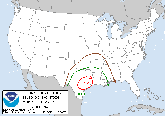
Re: 2008 Severe Weather Thread- MDT risk on Saturday in SE Texas
Main threat is hail at this point, so an upgrade to HIGH is very unlikely since the tornado threat needs to boost up. (Hail cannot trigger a High Risk)
0 likes
-
wbug1
Re: 2008 Severe Weather Thread- MDT risk on Saturday in SE Texas
That's news to me. A large outbreak of hail, although not likely to kill or injure as even a relatively weak structure will offer protection, can and has caused a great deal of damage before.
0 likes
-
Ed Mahmoud
Re: 2008 Severe Weather Thread- MDT risk on Saturday in SE Texas
CrazyC83 wrote:Main threat is hail at this point, so an upgrade to HIGH is very unlikely since the tornado threat needs to boost up. (Hail cannot trigger a High Risk)
I'm not sure where you got that from. Snip of SPC SWODY2
ATTENTION WILL THEN TURN DOWNSTREAM IN THE DESTABILIZING WARM SECTOR DURING THE AFTN...AS THE CAP ERODES AND ADDITIONAL STORMS DEVELOP. CONVECTIVE MODE WILL PROBABLY REMAIN DISCRETE AHEAD OF THE APCHG COLD FRONT ACROSS PORTIONS OF CNTRL/ECNTRL TX SWD TO THE MIDDLE TX COAST.
BULK SHEAR VALUES WILL BE MORE THAN SUFFICIENT FOR SUPERCELLS AND
GIVEN MAGNITUDE OF LAPSE RATES...VERY LARGE HAIL MAY RESULT.
CONCERN FOR STRONG TORNADOES WILL EXIST...ESPECIALLY WITH THE
DISCRETE STORMS. FCST HODOGRAPHS SUGGEST THAT 0-1KM EFFECTIVE STORM
RELATIVE SHEAR VALUES WILL BE IN EXCESS OF 400 M2/S2.
This model forecast sounding for Conroe looks more ominous, tornado wise, than the forecast soundings before the Super Tuesday outbreak.

0 likes
-
serenata09
- Tropical Storm

- Posts: 166
- Joined: Fri Jan 18, 2008 7:55 pm
- Location: Dallas, TX
Re: 2008 Severe Weather Thread- MDT risk on Saturday in SE Texas
Could someone explain to me how to make sense of a sounding?
0 likes
-
Ed Mahmoud
Re: 2008 Severe Weather Thread- MDT risk on Saturday in SE Texas
Ohio State University's twister web site has some explanations of things on the sounding. I look for strong winds in the lowest levels, changing with direction. (The far right hand side has wind speed and direction, direction by orientation and speed via the wind barbs, a half line is 5 knots, full line is 10 knots, triangle 50 knots), instability, first and foremost CAPE, although if there is a temperature inversion near the surface I also look at the total totals index, a difference between 850 mb temps and dewpoints and 500 mb temps. Anything over 50 is pretty supportive of severe weather. If there is any kind of CAPE, I look at helicity, and, as a cheat, for the non-weather educated like myself, I look at the EHI, a product of both CAPE and helicity. An EHI of 2.6 is also supportive of tornadoes. One negative for tornadoes I see is that the CAPE looks small near surface, with most of it between 700 mb and 250 mb (3 km to about 10.6 km), but the helicity is so high, I suspect it will more than compensate.
For tornadoes, lower cloud bases and levels of free convection are also net pluses for increasing tornado risk.
For tornadoes, lower cloud bases and levels of free convection are also net pluses for increasing tornado risk.
0 likes
-
Ed Mahmoud
Re: 2008 Severe Weather Thread- MDT risk on Saturday in SE Texas
Rough and dirty description found at bottom of each link on this page.
http://twister.sbs.ohio-state.edu/severe.html
http://twister.sbs.ohio-state.edu/severe.html
0 likes
-
Squarethecircle
- Category 5
- Posts: 2165
- Joined: Fri Oct 19, 2007 4:00 pm
- Location: Fairfax, VA
Re: 2008 Severe Weather Thread- MDT risk on Saturday in SE Texas
Ed Mahmoud wrote:CrazyC83 wrote:Main threat is hail at this point, so an upgrade to HIGH is very unlikely since the tornado threat needs to boost up. (Hail cannot trigger a High Risk)
I'm not sure where you got that from. Snip of SPC SWODY2ATTENTION WILL THEN TURN DOWNSTREAM IN THE DESTABILIZING WARM SECTOR DURING THE AFTN...AS THE CAP ERODES AND ADDITIONAL STORMS DEVELOP. CONVECTIVE MODE WILL PROBABLY REMAIN DISCRETE AHEAD OF THE APCHG COLD FRONT ACROSS PORTIONS OF CNTRL/ECNTRL TX SWD TO THE MIDDLE TX COAST.
BULK SHEAR VALUES WILL BE MORE THAN SUFFICIENT FOR SUPERCELLS AND
GIVEN MAGNITUDE OF LAPSE RATES...VERY LARGE HAIL MAY RESULT.
CONCERN FOR STRONG TORNADOES WILL EXIST...ESPECIALLY WITH THE
DISCRETE STORMS. FCST HODOGRAPHS SUGGEST THAT 0-1KM EFFECTIVE STORM
RELATIVE SHEAR VALUES WILL BE IN EXCESS OF 400 M2/S2.
This model forecast sounding for Conroe looks more ominous, tornado wise, than the forecast soundings before the Super Tuesday outbreak.
0 likes
-
serenata09
- Tropical Storm
- Posts: 166
- Joined: Fri Jan 18, 2008 7:55 pm
- Location: Dallas, TX
Re: 2008 Severe Weather Thread- MDT risk on Saturday in SE Texas
RL3AO wrote:Relative shear 400 m2/s2? Is it just me, or does that sound insanely high?
What does that even mean?
0 likes
Re: 2008 Severe Weather Thread- MDT risk on Saturday in SE Texas
serenata09 wrote:RL3AO wrote:Relative shear 400 m2/s2? Is it just me, or does that sound insanely high?
What does that even mean?
400 meters squared per second squared.
0 likes
-
Squarethecircle
- Category 5
- Posts: 2165
- Joined: Fri Oct 19, 2007 4:00 pm
- Location: Fairfax, VA
Re:
RL3AO wrote:Relative shear 400 m2/s2? Is it just me, or does that sound insanely high?
So high I'd think it might be a typo, if the alternative wasn't only 40.
0 likes
Return to “USA & Caribbean Weather”
Who is online
Users browsing this forum: Brent, Kingarabian, rwfromkansas, Stratton23, WaveBreaking and 69 guests