2008 Severe Weather Thread

U.S. & Caribbean Weather Discussions and Severe Weather Events

Moderator: S2k Moderators

Forum rules

The posts in this forum are NOT official forecast and should not be used as such. They are just the opinion of the poster and may or may not be backed by sound meteorological data. They are NOT endorsed by any professional institution or STORM2K.

Help Support Storm2K
Message
Author
Squarethecircle
Category 5
Category 5
Posts: 2165
Joined: Fri Oct 19, 2007 4:00 pm
Location: Fairfax, VA

Re: 2008 Severe Weather thread

#121 Postby Squarethecircle » Sun Feb 17, 2008 1:56 pm

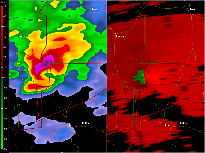
baygirl_1 wrote:Our weather (central Mobile County) is going downhill fast now. We've been watching WKRG for over an hour now talking about the weather to our north and east, but now the squall line is bearing down on us. As I type, our little doggie is under my feet-- he does not like this at all. The weather radio has gone off 3 times in the last hour here. However, we haven't had it as bad as Baldwin County and Escambia County, FL (and hope we don't). The storm that brought the tornado to the Molina, FL area actually came in from the Gulf near Fort Morgan peninsula and tracked thru Baldwin County into Florida. It was amazing to watch it cycle down then cycle back up again. I tried to find a live webcast from here to share with y'all, but none of the local TV stations are doing that. Okay, thunder is getting louder, lightning brighter, and rain harder-- so I better get off this thing and pay better attention to that.


Hide, you're about to get slammed.
0 likes   

User avatar
HarlequinBoy
Category 5
Category 5
Posts: 1400
Age: 34
Joined: Wed Nov 29, 2006 1:57 am
Location: Memphis

#122 Postby HarlequinBoy » Sun Feb 17, 2008 2:01 pm

1243 PM TSTM WND DMG 10 N SELMA 32.56N 87.03W
02/17/2008 DALLAS AL EMERGENCY MNGR

POSSIBLE TORNADO...SIGNIFICANT DAMAGE IN THE SUMMERFIELD
AREA. NO DETAILS AT THIS TIME.
0 likes   

User avatar
HarlequinBoy
Category 5
Category 5
Posts: 1400
Age: 34
Joined: Wed Nov 29, 2006 1:57 am
Location: Memphis

#123 Postby HarlequinBoy » Sun Feb 17, 2008 2:03 pm

THE LOCATION WAS CLOSE TO
THE SANTA ROSA AND ESCAMBIA COUNTY ALABAMA LINE. TRAINED WEATHER
SPOTTERS VERY NEAR THE STORM HAVE REPORTED A WALL CLOUD BUT LATEST
RADAR DATA SHOWS THAT THE CIRCULATION MAY BE STRENGTHENING ONCE
AGAIN.

^Just a note, I really like the warnings Mobile puts out. They're very informative..
0 likes   

Squarethecircle
Category 5
Category 5
Posts: 2165
Joined: Fri Oct 19, 2007 4:00 pm
Location: Fairfax, VA

#124 Postby Squarethecircle » Sun Feb 17, 2008 2:03 pm

:uarrow: I see it. It doesn't look good (for Dallas County, that is).
0 likes   

Brent
S2K Supporter
S2K Supporter
Posts: 37988
Age: 36
Joined: Sun May 16, 2004 10:30 pm
Location: Tulsa Oklahoma
Contact:

Re:

#125 Postby Brent » Sun Feb 17, 2008 2:09 pm

HarlequinBoy wrote:1243 PM TSTM WND DMG 10 N SELMA 32.56N 87.03W
02/17/2008 DALLAS AL EMERGENCY MNGR

POSSIBLE TORNADO...SIGNIFICANT DAMAGE IN THE SUMMERFIELD
AREA. NO DETAILS AT THIS TIME.


Haven't heard anything else about it, it's a very rural area luckily.

Edit: OK, local TV just said there's only roof damage there apparently.
0 likes   

Brent
S2K Supporter
S2K Supporter
Posts: 37988
Age: 36
Joined: Sun May 16, 2004 10:30 pm
Location: Tulsa Oklahoma
Contact:

Re: 2008 Severe Weather thread

#126 Postby Brent » Sun Feb 17, 2008 2:44 pm

Tornado sirens going off for the second time in less than two weeks. I'm not technically in the polygon, yet.

Several reports of tornadoes with this.

* TORNADO WARNING FOR...
NORTHWESTERN CHAMBERS COUNTY IN EAST CENTRAL ALABAMA...
SOUTHERN CLAY COUNTY IN EAST CENTRAL ALABAMA...
THIS INCLUDES THE CITY OF ASHLAND...
NORTHEASTERN COOSA COUNTY IN EAST CENTRAL ALABAMA...
THIS INCLUDES THE CITIES OF...KELLYTON...GOODWATER...
SOUTHWESTERN RANDOLPH COUNTY IN EAST CENTRAL ALABAMA...
NORTHERN TALLAPOOSA COUNTY IN EAST CENTRAL ALABAMA...

* UNTIL 215 PM CST

* AT 136 PM CST...NATIONAL WEATHER SERVICE DOPPLER RADAR INDICATED A
SEVERE THUNDERSTORM CAPABLE OF PRODUCING A TORNADO NEAR HATCHET...
OR 7 MILES NORTHEAST OF ROCKFORD...MOVING NORTHEAST AT 55 MPH.

* THE TORNADO WILL BE NEAR...
GOODWATER BY 145 PM CST...
CLEVELAND CROSSROADS AND HACKNEYVILLE BY 150 PM CST...
MILLERVILLE BY 155 PM CST...
MELLOW VALLEY AND ASHLAND BY 205 PM CST...
CRAGFORD AND LINEVILLE BY 210 PM CST...
6 MILES SOUTHEAST OF BARFIELD BY 215 PM CST...
0 likes   

Squarethecircle
Category 5
Category 5
Posts: 2165
Joined: Fri Oct 19, 2007 4:00 pm
Location: Fairfax, VA

#127 Postby Squarethecircle » Sun Feb 17, 2008 2:54 pm

:eek: This is not anything like I expected.
0 likes   

User avatar
Bunkertor
Category 5
Category 5
Posts: 3397
Joined: Tue May 09, 2006 3:48 pm

A smart page for an overview

#128 Postby Bunkertor » Sun Feb 17, 2008 2:55 pm

0 likes   

User avatar
Bunkertor
Category 5
Category 5
Posts: 3397
Joined: Tue May 09, 2006 3:48 pm

Re:

#129 Postby Bunkertor » Sun Feb 17, 2008 3:04 pm

Squarethecircle wrote::eek: This is not anything like I expected.


True - this line looks strong. It will be traveling for some more miles, i think. But satellite doesn´t show overshooting tops.
0 likes   

CrazyC83
Professional-Met
Professional-Met
Posts: 34001
Joined: Tue Mar 07, 2006 11:57 pm
Location: Deep South, for the first time!

#130 Postby CrazyC83 » Sun Feb 17, 2008 3:08 pm

Seems like one mean supercell trying to do all the work...surprised no upgrade to MDT...
0 likes   

CrazyC83
Professional-Met
Professional-Met
Posts: 34001
Joined: Tue Mar 07, 2006 11:57 pm
Location: Deep South, for the first time!

#131 Postby CrazyC83 » Sun Feb 17, 2008 3:08 pm

Tornadoes
Probability of 2 or more tornadoes
High (80%)


Probability of 1 or more strong (F2-F5) tornadoes
Mod (50%)


Wind
Probability of 10 or more severe wind events
Mod (50%)


Probability of 1 or more wind events > 65 knots
Mod (30%)


Hail
Probability of 10 or more severe hail events
Mod (40%)


Probability of 1 or more hailstones > 2 inches
Mod (30%)


Combined Severe Hail/Wind
Probability of 6 or more combined severe hail/wind events
High (>95%)


Those numbers usually warrant a PDS watch...
0 likes   

RL3AO
Moderator-Pro Met
Moderator-Pro Met
Posts: 16308
Joined: Thu Jun 14, 2007 10:03 pm
Location: NC

Re: 2008 Severe Weather thread

#132 Postby RL3AO » Sun Feb 17, 2008 3:10 pm

Check this out.

Image

MESOSCALE DISCUSSION 0259
NWS STORM PREDICTION CENTER NORMAN OK
1252 PM CST SUN FEB 17 2008

AREAS AFFECTED...IL...MI...IN

CONCERNING...SEVERE POTENTIAL...WATCH UNLIKELY

VALID 171852Z - 172015Z

ISOLATED HAIL AND/OR A DAMAGING WIND GUST/BRIEF TORNADO NOT OUT OF
THE QUESTION ALONG THE IL/IN BORDER NEWD TO SWRN LOWER MI NEXT
COUPLE OF HOURS. OVERALL THREAT CURRENTLY APPEARS TOO LIMITED IN
TIME/SPACE TO WARRANT A WATCH. ADDITIONALLY...PRE-FRONTAL LINE OF
LOW-TOPPED CONVECTION...CURRENTLY WITH NO CG LTG...MAY RESULT IN
BRIEF INCREASES IN ALREADY STRONG GRADIENT WIND FIELD.

INTENSE DYNAMIC FORCING FOR ASCENT WITHIN WEAKLY UNSTABLE AIR MASS
APPEARS TO BE SUPPORTING LOW-TOPPED TSTM DEVELOPMENT ACROSS PARTS OF
IROQUOIS COUNTY IL ATTM. THIS DEVELOPMENT IS IN RESPONSE TO FOCUSED
DEEP-LAYER ASCENT ON THE CYCLONIC SHEAR SIDE OF 90-100KT MID LEVEL
JET STREAK SPREADING NEWD ACROSS THE MIDWEST THIS AFTERNOON.
NORMALLY...INTENSE SHEAR WITHIN SUCH A WEAK INSTABILITY REGIME WOULD
MAKE IT DIFFICULT TO SUSTAIN UPDRAFT INTEGRITY LONG ENOUGH TO RESULT
IN SUPERCELL STORM FORMATION. HOWEVER...POCKETS OF STRONGER HEATING
/TEMPS IN THE 50S F/ AND BOUNDARY LAYER MIXING SUGGEST THAT
SURFACE-BASED PARCELS LIKELY CAN ACHIEVE WEAK BUOYANCY. GIVEN
INTENSE FLOW FIELDS...ONE OR TWO STRONGER UPDRAFTS MAY ACQUIRE
ROTATION LONG ENOUGH FOR A BRIEF SEVERE EVENT. POTENTIAL APPEAR TOO
LIMITED TO JUSTIFY A WATCH BUT AREA WILL CONTINUE TO BE MONITORED.

FARTHER EAST...LINE OF CONVECTION HAS DEVELOPED WITHIN STRONG
CYCLONIC FLOW FIELD ACROSS ERN IND. IT CURRENTLY APPEARS THAT A
BRIEF INCREASE IN 40-45KT GRADIENT WIND GUSTS MAY OCCUR AS THIS
CONVECTION MOVES ACROSS ERN IN. THIS AREA WILL ALSO BE MONITORED FOR
INCREASING REFLECTIVITY/LTG BUT WATCH IS NOT IMMINENT.

..CARBIN.. 02/17/2008
0 likes   

CrazyC83
Professional-Met
Professional-Met
Posts: 34001
Joined: Tue Mar 07, 2006 11:57 pm
Location: Deep South, for the first time!

#133 Postby CrazyC83 » Sun Feb 17, 2008 3:12 pm

SEVERE WEATHER STATEMENT
NATIONAL WEATHER SERVICE TALLAHASSEE FL
305 PM EST SUN FEB 17 2008

ALC031-172030-
/O.CON.KTAE.TO.W.0007.000000T0000Z-080217T2030Z/
COFFEE AL-
205 PM CST SUN FEB 17 2008

...A TORNADO WARNING REMAINS IN EFFECT UNTIL 230 PM CST FOR NORTHERN
COFFEE COUNTY...

AT 203 PM CST...NATIONAL WEATHER SERVICE DOPPLER RADAR WAS TRACKING
A LARGE AND DANGEROUS TORNADO. THIS TORNADO WAS LOCATED 6 MILES
SOUTHWEST OF NEWBY...OR 11 MILES NORTHWEST OF ELBA...MOVING
NORTHEAST AT 45 MPH.

THE TORNADO WILL BE NEAR...
NEWBY BY 210 PM CST...
SHADY GROVE BY 215 PM CST...
JACK BY 220 PM CST...
6 MILES NORTHWEST OF VICTORIA BY 225 PM CST...
ROETON BY 225 PM CST...

THIS TORNADO HAS HAD A HISTORY OF PRODUCING SIGNIFICANT DAMAGE ALONG
ITS PATH. IF YOU ARE IN NORTHERN COFFEE COUNTY...SEEK A STURDY
STRUCTURE IMMEDIATELY!

IN ADDITION TO THE TORNADO...THIS STORM IS CAPABLE OF PRODUCING
BASEBALL SIZE HAIL AND DESTRUCTIVE STRAIGHT LINE WINDS.

THIS IS AN EXTREMELY DANGEROUS AND LIFE THREATENING SITUATION. THIS
STORM IS CAPABLE OF PRODUCING STRONG TORNADOES. IF YOU ARE IN THE
PATH OF THIS TORNADO...TAKE COVER IMMEDIATELY!


RELAY REPORTS OF SEVERE WEATHER TO THE NATIONAL WEATHER SERVICE IN
TALLAHASSEE AT (8 5 0) 9 4 2 8 8 3 3. OR...YOU MAY CONTACT THE
NEAREST LAW ENFORCEMENT AGENCY OR YOUR COUNTY EMERGENCY MANAGEMENT.
THEY WILL RELAY YOUR REPORT TO THE NATIONAL WEATHER SERVICE.

A TORNADO WATCH REMAINS IN EFFECT UNTIL 800 PM CST SUNDAY EVENING FOR
SOUTHEAST ALABAMA AND CENTRAL FLORIDA AND SOUTHWEST GEORGIA.

LAT...LON 3156 8586 3149 8599 3142 8619 3144 8618
3154 8619 3154 8614 3163 8613 3163 8580
TIME...MOT...LOC 2005Z 244DEG 41KT 3152 8619

$$

38-GODSEY
0 likes   

User avatar
Bunkertor
Category 5
Category 5
Posts: 3397
Joined: Tue May 09, 2006 3:48 pm

Re:

#134 Postby Bunkertor » Sun Feb 17, 2008 3:12 pm

CrazyC83 wrote:Tornadoes
Probability of 2 or more tornadoes
High (80%)


Those numbers usually warrant a PDS watch...


Where are these numbers from ?
0 likes   

CrazyC83
Professional-Met
Professional-Met
Posts: 34001
Joined: Tue Mar 07, 2006 11:57 pm
Location: Deep South, for the first time!

Re: 2008 Severe Weather thread

#135 Postby CrazyC83 » Sun Feb 17, 2008 3:13 pm

SEVERE WEATHER STATEMENT
NATIONAL WEATHER SERVICE BIRMINGHAM AL
208 PM CST SUN FEB 17 2008

ALC005-011-109-172045-
/O.CON.KBMX.TO.W.0046.000000T0000Z-080217T2045Z/
PIKE AL-BARBOUR AL-BULLOCK AL-
208 PM CST SUN FEB 17 2008

...A TORNADO WARNING REMAINS IN EFFECT UNTIL 245 PM CST FOR SOUTH
CENTRAL BULLOCK...WESTERN BARBOUR AND PIKE COUNTIES...

AT 204 PM CST...NATIONAL WEATHER SERVICE DOPPLER RADAR AND STORM
SPOTTERS WERE TRACKING A LARGE AND EXTREMELY DANGEROUS TORNADO. THIS
TORNADO WAS LOCATED 10 MILES SOUTHWEST OF HENDERSON...OR ABOUT 12
MILES SOUTH OF GOSHEN...MOVING NORTHEAST AT 50 MPH.

THE TORNADO WILL BE NEAR...
HENDERSON BY 215 PM CST...
MOSSY GROVE BY 225 PM CST...
ANTIOCH...BRUNDIDGE MUNICIPAL AIRPORT AND BRUNDIDGE BY 230 PM
CST...
BANKS BY 235 PM CST...
MONTICELLO BY 240 PM CST...
JOSIE...TANYARD AND BOOT HILL BY 245 PM CST...

THE SAFEST PLACE TO BE DURING A TORNADO IS IN A BASEMENT. GET UNDER A
WORKBENCH OR OTHER PIECE OF STURDY FURNITURE. IF NO BASEMENT IS
AVAILABLE...SEEK SHELTER ON THE LOWEST FLOOR OF THE BUILDING IN AN
INTERIOR HALLWAY OR ROOM SUCH AS A CLOSET. USE BLANKETS OR PILLOWS TO
COVER YOUR BODY AND ALWAYS STAY AWAY FROM WINDOWS.

IF IN MOBILE HOMES OR VEHICLES...EVACUATE THEM AND GET INSIDE A
SUBSTANTIAL SHELTER. IF NO SHELTER IS AVAILABLE...LIE FLAT IN THE
NEAREST DITCH OR OTHER LOW SPOT AND COVER YOUR HEAD WITH YOUR HANDS.

LAT...LON 3165 8617 3168 8615 3178 8615 3179 8618
3186 8612 3214 8560 3193 8540 3164 8543
3161 8552 3162 8617
TIME...MOT...LOC 2008Z 233DEG 46KT 3159 8613

$$

27
0 likes   

CrazyC83
Professional-Met
Professional-Met
Posts: 34001
Joined: Tue Mar 07, 2006 11:57 pm
Location: Deep South, for the first time!

Re: Re:

#136 Postby CrazyC83 » Sun Feb 17, 2008 3:14 pm

Bunkertor wrote:
CrazyC83 wrote:Tornadoes
Probability of 2 or more tornadoes
High (80%)


Those numbers usually warrant a PDS watch...


Where are these numbers from ?


The SPC site for the last tornado watch (the only one in effect at the moment). Probably the more localized nature held them back from going PDS.
0 likes   

RL3AO
Moderator-Pro Met
Moderator-Pro Met
Posts: 16308
Joined: Thu Jun 14, 2007 10:03 pm
Location: NC

#137 Postby RL3AO » Sun Feb 17, 2008 3:14 pm

Image
0 likes   

User avatar
baygirl_1
S2K Supporter
S2K Supporter
Posts: 825
Joined: Wed Aug 11, 2004 4:06 pm
Location: Mobile, AL

Re: 2008 Severe Weather thread

#138 Postby baygirl_1 » Sun Feb 17, 2008 3:15 pm

Well, it wasn't too bad for us here. It was loud for about 10 min., but fortunately nothing really nasty. The local TV has gone back to normal programming here (DH is so glad to have the Daytona 500 stuff on and we're due @ a NASCAR party in a bit-- I'm not really into it, but...). They are warning the folks in Molino, FL who are trying to pick up after the reported tornado there to be aware that the squall line is now bearing down on them. Here's a link to a news story about the situation in Molino:
http://www.wkrg.com/news/article/weather_damage_reported_in_nwfl/10420/
0 likes   

User avatar
Bunkertor
Category 5
Category 5
Posts: 3397
Joined: Tue May 09, 2006 3:48 pm

#139 Postby Bunkertor » Sun Feb 17, 2008 3:15 pm

0 likes   

RL3AO
Moderator-Pro Met
Moderator-Pro Met
Posts: 16308
Joined: Thu Jun 14, 2007 10:03 pm
Location: NC

#140 Postby RL3AO » Sun Feb 17, 2008 3:15 pm

Image
0 likes   


Return to “USA & Caribbean Weather”

Who is online

Users browsing this forum: Google Adsense [Bot] and 5 guests