That storm today... was massively dissappointing...
Not a drop...
Florida Weather
Moderator: S2k Moderators
Forum rules

The posts in this forum are NOT official forecast and should not be used as such. They are just the opinion of the poster and may or may not be backed by sound meteorological data. They are NOT endorsed by any professional institution or STORM2K.
Re: Florida Weather Thread-Wet today
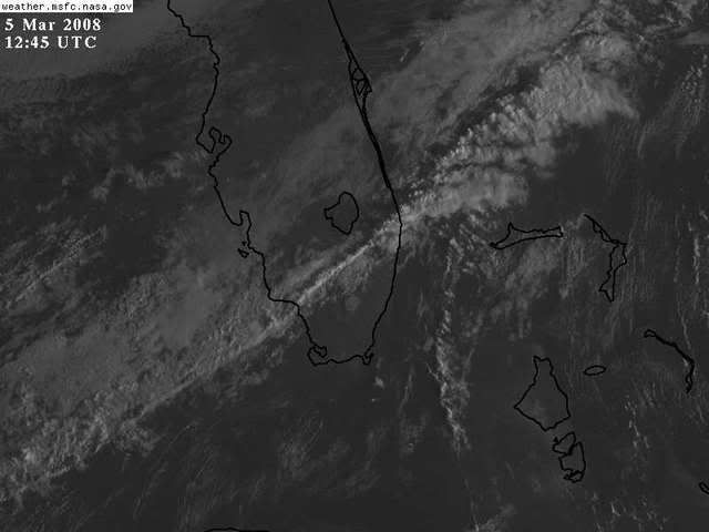
Well you can see how the dry slot seeks us. We got 60 seconds of shower from a random cell.
0 likes


-
Tampa Bay Hurricane

- Category 5

- Posts: 5597
- Age: 38
- Joined: Fri Jul 22, 2005 7:54 pm
- Location: St. Petersburg, FL
Re: Florida Weather Thread-Wet today
Traveled to the north side of Tampa to USF, there are some branches
down, one of the cells yesterday may have produced wind gusts of 50 mph or
so in this area.
Thursday night and Friday could feature an outbreak of
severe weather for the florida peninsula. Strong warm
air advection with a warm front moving north tomorrow will
pump in a lot of moist tropical air and high dew points. An area
of low pressure is expected to form and ride this front. The low
may interact with strong directional shear to produce strong
to severe thunderstorms especially north of Tampa, but strong
thunderstorms with damaging winds will be possible for the entire
peninsula combing these factors.
I expect winds to increase tomorrow as the warm front lifts
north with scattered thunderstorms developing along the warm
front. Then, as the low and associated cold front move in, I expect
a cluster and squall line of severe thunderstorms to sweep
the florida peninsula Friday afternoon, and with day time heating
some of the storms are likely to be severe with wind gusts
in excess of 70 mph. I expect winds to reach a baseline 30 mph
in gusts associated just with the low pressure area. Strong thunderstorms
are likely to produce damaging winds with daytime heat, high dew points, high
instability, and strong directional shear on Friday.
0 likes
-
Tampa Bay Hurricane
- Category 5
- Posts: 5597
- Age: 38
- Joined: Fri Jul 22, 2005 7:54 pm
- Location: St. Petersburg, FL
Re: Florida Weather Thread-Wet today
Storm2k Weather Forecast:
ZoneCast:
Dated: 406 AM EST WED MAR 05 2008 Expires: 400 PM EST WED MAR 05 2008
Includes the Counties: Pasco, Pinellas, Hillsborough, Polk
Includes the Cities: New Port Richey, Zephyrhills, Clearwater, St. Petersburg, Brandon, Tampa, Lakeland, Winter Haven
Today...Becoming partly cloudy with a 20 percent chance of showers. Highs 70 to 75. Northwest winds 5 to 10 mph.
Tonight...Partly cloudy with a 20 percent chance of showers in the evening...Then mostly clear after midnight. Patchy fog after midnight. Lows in the lower 50s inland to the upper 50s near the coast. Light winds.
Thursday...Partly cloudy with a 20 percent chance of showers. Highs in the mid 70s. East winds 5 to 10 mph.
Thursday Night...Mostly cloudy with chance of showers and slight chance of thunderstorms. Lows 60 to 65. East winds 5 to 10 mph becoming southeast 10 to 15 mph after midnight. Chance of rain 40 percent.
Friday...Mostly cloudy with chance of showers and slight chance of thunderstorms. Highs 75 to 80. South winds 10 to 20 mph with higher gusts. Chance of rain 50 percent.
Friday Night...Mostly cloudy with chance of showers and slight chance of thunderstorms in the evening...Then partly cloudy with chance of showers after midnight. Lows in the lower 60s. Chance of rain 50 percent.
Saturday...Partly cloudy. Highs in the upper 60s.
Saturday Night...Mostly clear. Lows in the mid 40s. Highs in the upper 60s.
Sunday...Mostly clear. Lows in the mid 40s. Highs in the upper 60s.
Monday...Mostly clear. Highs in the mid 70s. Lows in the lower 50s.
Monday Night...Mostly clear. Highs in the mid 70s. Lows in the lower 50s.
Tuesday...Partly cloudy. Highs in the mid 70s.
Storm2k.org.
Copyright © 2001 - 2007.
US Forecasts are Public Domain and derived from the
National Weather Service - (IWIN) and the National Oceanic Atmospheric Administration (NOAA)
0 likes


-
flwxwatcher
- Category 4

- Posts: 926
- Joined: Wed May 16, 2007 3:35 pm
- Location: Central Florida
Re: Florida Weather Thread-Wet today
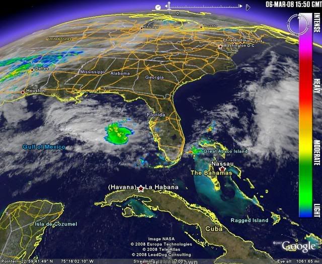
Nice convective complex offshore Tampa Bay heading toward the West Coast. Tomorrow SPC has North and Central Florida in a slight risk area
0 likes
-
Evil Jeremy

- S2K Supporter

- Posts: 5463
- Age: 32
- Joined: Mon Apr 10, 2006 2:10 pm
- Location: Los Angeles, CA
Re: Florida Weather Thread-Wet today
SEVERE THUNDERSTORM WARNING
FLC011-061845-
/O.NEW.KMFL.SV.W.0009.080306T1756Z-080306T1845Z/
BULLETIN - EAS ACTIVATION REQUESTED
SEVERE THUNDERSTORM WARNING
NATIONAL WEATHER SERVICE MIAMI FL
1256 PM EST THU MAR 6 2008
THE NATIONAL WEATHER SERVICE IN MIAMI HAS ISSUED A
* SEVERE THUNDERSTORM WARNING FOR...
SOUTHEASTERN BROWARD COUNTY IN SOUTH FLORIDA.
* UNTIL 145 PM EST
* AT 1254 PM EST...NATIONAL WEATHER SERVICE DOPPLER RADAR INDICATED A
SEVERE THUNDERSTORM CAPABLE OF PRODUCING PENNY SIZE HAIL...AND
DAMAGING WINDS IN EXCESS OF 60 MPH. THIS STORM WAS LOCATED NEAR
HOLLYWOOD...AND MOVING NORTHEAST AT 6 MPH.
* THE STORM WILL AFFECT...
HOLLYWOOD...
PLANTATION...
DANIA BEACH...
PORT EVERGLADES...
AND SURROUNDING COMMUNITIES.
SEVERE THUNDERSTORMS CAN PRODUCE VERY STRONG WINDS IN EXCESS OF 60
MPH...LARGE HAIL...DEADLY LIGHTNING...AND VERY HEAVY RAINFALL. STAY
INSIDE AWAY FROM WINDOWS UNTIL THE STORM HAS PASSED.
SEVERE THUNDERSTORMS CAN ALSO PRODUCE TORNADOES WITH LITTLE OR NO
ADVANCE WARNING. PREPARE TO MOVE TO A PLACE OF SAFETY IN AN INTERIOR
ROOM IN THE LOWEST FLOOR OF YOUR HOUSE OR BUSINESS IF A TORNADO IS
SPOTTED.
LAT...LON 2599 8011 2598 8028 2612 8026 2614 8010
TIME...MOT...LOC 1756Z 217DEG 5KT 2604 8018
$$
GREGORIA
I am in Plantation now, and will be in Hollywood later tonight. I will report on what I see as the conditions get worse in my area.
0 likes
-
JonathanBelles
- Professional-Met

- Posts: 11430
- Age: 35
- Joined: Sat Dec 24, 2005 9:00 pm
- Location: School: Florida State University (Tallahassee, FL) Home: St. Petersburg, Florida
- Contact:
-
JonathanBelles
- Professional-Met
- Posts: 11430
- Age: 35
- Joined: Sat Dec 24, 2005 9:00 pm
- Location: School: Florida State University (Tallahassee, FL) Home: St. Petersburg, Florida
- Contact:
Manatee county northwards to Hernando/Citrus and later southwards into sarasota county should be expecting showers and t-storms in the next few hours.
THIS HAZARDOUS WEATHER OUTLOOK IS FOR WEST CENTRAL AND SOUTHWEST
FLORIDA.
.DAY ONE...TODAY AND TONIGHT.
ISOLATED THUNDERSTORMS WILL PRODUCE A FEW FLASHES OF DEADLY
LIGHTNING AND GUSTY WINDS WHILE ASSOCIATED RAIN LOWERS VISIBILITIES.
ALSO SOME HAIL MAY FALL IN THE STRONGER STORMS...ESPECIALLY OVER
SOUTHWEST FLORIDA THIS AFTERNOON. WINDS WILL BE INCREASING OVER THE
GULF LATE TONIGHT.
0 likes
-
flwxwatcher
- Category 4
- Posts: 926
- Joined: Wed May 16, 2007 3:35 pm
- Location: Central Florida
Re: Florida Weather Thread-Wet today
I wouldn't be surprised to see some hail in some Tstm's today. This mornings 500MB temp at Tampa came in at -16C
0 likes
-
Evil Jeremy
- S2K Supporter
- Posts: 5463
- Age: 32
- Joined: Mon Apr 10, 2006 2:10 pm
- Location: Los Angeles, CA
Re: Florida Weather Thread-Wet today
FLOOD ADVISORY
NATIONAL WEATHER SERVICE MIAMI FL
118 PM EST THU MAR 6 2008
FLC011-062015-
/X.NEW.KMFL.FA.Y.0004.080306T1818Z-080306T2015Z/
/00000.N.ER.000000T0000Z.000000T0000Z.000000T0000Z.OO/
118 PM EST THU MAR 6 2008
THE NATIONAL WEATHER SERVICE IN MIAMI HAS ISSUED AN
* URBAN FLOOD ADVISORY FOR...
EASTERN BROWARD COUNTY IN SOUTHEAST FLORIDA...
THIS INCLUDES THE CITIES OF...TAMARAC...SUNRISE...POMPANO BEACH...
PLANTATION...MARGATE...HOLLYWOOD...HALLANDALE...FORT LAUDERDALE...
DEERFIELD BEACH...DAVIE...CORAL SPRINGS...
* UNTIL 315 PM EST
* AT 118 PM EST...NATIONAL WEATHER SERVICE DOPPLER RADAR INDICATED
SLOW MOVING THUNDERSTORMS WITH HEAVY RAIN OCCURRING OVER THE BROWARD
METRO AREA. 2.1 INCHES OF RAIN WAS RECORDED IN ONLY A HALF HOURS
TIME IN HOLLYWOOD. THESE HEAVY RAINFALL RATES WILL LEAD TO URBAN
FLOODING...WITH THE MOST PRONE AREAS OVER SOUTHEAST BROWARD COUNTY.
MOST FLOOD DEATHS OCCUR IN AUTOMOBILES. NEVER DRIVE YOUR VEHICLE INTO
AREAS WHERE THE WATER COVERS THE ROADWAY. FLOOD WATERS ARE USUALLY
DEEPER THAN THEY APPEAR. JUST ONE FOOT OF FLOWING WATER IS POWERFUL
ENOUGH TO SWEEP VEHICLES OFF THE ROAD. WHEN ENCOUNTERING FLOODED
ROADS MAKE THE SMART CHOICE...TURN AROUND...DONT DROWN.
LAT...LON 2620 8009 2620 8010 2618 8010 2610 8010
2610 8011 2609 8010 2598 8011 2597 8032
2633 8030 2632 8008
TIME...MOT...LOC 1818Z 250DEG 4KT 2605 8019
$$
GREGORIA
0 likes
-
JonathanBelles
- Professional-Met
- Posts: 11430
- Age: 35
- Joined: Sat Dec 24, 2005 9:00 pm
- Location: School: Florida State University (Tallahassee, FL) Home: St. Petersburg, Florida
- Contact:
Re: Florida Weather Thread-Wet today
Nothing for us like usual. Another system that if it happened in August.
0 likes
-
JonathanBelles
- Professional-Met
- Posts: 11430
- Age: 35
- Joined: Sat Dec 24, 2005 9:00 pm
- Location: School: Florida State University (Tallahassee, FL) Home: St. Petersburg, Florida
- Contact: