
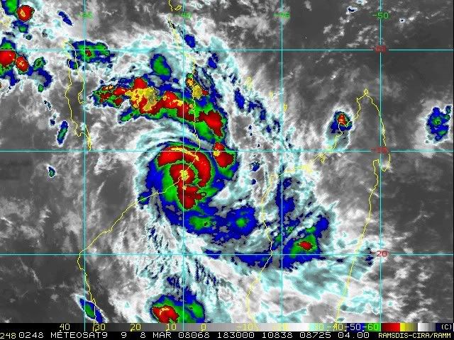
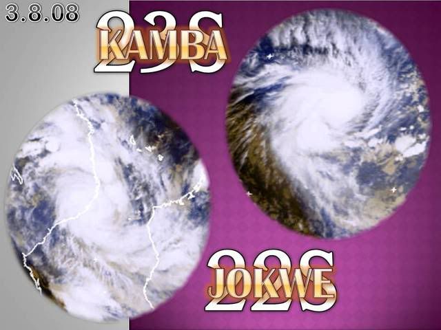
Mozambique Channel: Moderate Tropical Storm Jokwe (TC 22S)
Moderator: S2k Moderators
Re: Mozambique Channel: Intense Tropical Cyclone Jokwe (TC 22S)
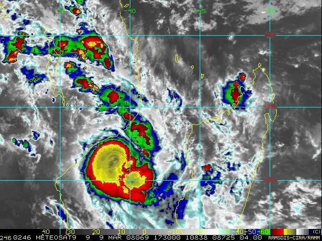
This is going to be devastating - now 100 kts on NRL
0 likes
-
Squarethecircle
- Category 5

- Posts: 2165
- Joined: Fri Oct 19, 2007 4:00 pm
- Location: Fairfax, VA


WTIO30 FMEE 081221
RSMC / TROPICAL CYCLONE CENTRE / LA REUNION
TROPICAL CYCLONE FORECAST WARNING (SOUTH-WEST INDIAN OCEAN)
0.A WARNING NUMBER : 16/12/20072008
1.A TROPICAL CYCLONE 12 (JOKWE)
2.A POSITION 2008/03/08 AT 1200 UTC :
15.8S / 40.3E
(FIFTEEN DECIMAL EIGHT DEGREES SOUTH AND FORTY DECIMAL THREE DEGREES EAST
)
3.A DVORAK ANALYSIS : 4.5/5.5 /W 1.5/12 H
4.A CENTRAL PRESSURE : 960 HPA
5.A MAX AVERAGE WIND SPEED (10 MN) : 85 KT
6.A EXTENSION OF WINDS BY QUADRANTS (KM):
30 KT NE: 080 SE: 100 SO: 100 NO: 080
50 KT NE: 020 SE: 020 SO: 020 NO: 020
7.A FIRST CLOSED ISOBARE (PRESSURE / AVERAGE DIAM): 1010 HPA / 500 KM
8.A VERTICAL EXTENSION OF CYCLONE CIRCULATION: DEEP
1.B FORECASTS:
12H: 2008/03/09 00 UTC: 16.6S/39.1E OVERLAND.
24H: 2008/03/09 12 UTC: 18.0S/38.1E, MAX WIND=025KT, TROP. DISTURBANCE.
36H: 2008/03/10 00 UTC: 19.1S/37.6E, MAX WIND=030KT, TROP. DEPRESSION.
48H: 2008/03/10 12 UTC: 20.2S/37.4E, MAX WIND=040KT, MODERATE TROP. STORM
.
60H: 2008/03/11 00 UTC: 21.6S/37.6E, MAX WIND=040KT, MODERATE TROP. STORM
.
72H: 2008/03/11 12 UTC: 22.8S/37.9E, MAX WIND=050KT, SEVERE TROP. STORM.
2.B OTHER INFORMATIONS:
T=4.5 CI=5.5-
THE SYSTEM HAS MADE A LANDFALL AT 1015Z BETWEEN MOCAMBIQUE ISLAND AND
ANGOCHE CITY. THE SUYSTEM SHOULD KEEP ON TRACKING SOUTHWESTWARDS ALONG
THE MOZAMBIQUE COASTLINE AND REEMERGE OVER WATER IN THE 12 TO 24 HOURS
NEXT HOURS. ENVIRONMENT SHOULD THEN ALLOW THE SYSTEM TO REINTENSIFY.
BEYOND TAU 48, THE SYSTEM SHOULD TRACK POLEWARDS TOWARDS A MID LATITUDES
TROUGH.
MSLP IS HIGHER THAN USUAL FOR THIS INTENSITY STAGE.
0 likes

-
Crostorm

- Category 5
- Posts: 2060
- Age: 51
- Joined: Mon Dec 25, 2006 3:51 pm
- Location: Croatia-Europe
- Contact:
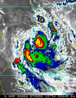
Re: Mozambique Channel: Tropical Cyclone Jokwe (TC 22S)
ZCZC 163
WTIO30 FMEE 081813 RRA
RSMC / TROPICAL CYCLONE CENTRE / LA REUNION
TROPICAL CYCLONE FORECAST WARNING (SOUTH-WEST INDIAN OCEAN)
0.A WARNING NUMBER : 17/12/20072008
1.A TROPICAL CYCLONE 12 (JOKWE)
2.A POSITION 2008/03/08 AT 1800 UTC :
16.3S / 39.9E
(SIXTEEN DECIMAL THREE DEGREES SOUTH AND THIRTY NINE DECIMAL NINE
DEGREES
EAST)
3.A DVORAK ANALYSIS : 4.5/5.0 /W
4.A CENTRAL PRESSURE : 960 HPA
5.A MAX AVERAGE WIND SPEED (10 MN) : 80 KT
6.A EXTENSION OF WINDS BY QUADRANTS (KM):
30 KT NE: 080 SE: 100 SO: 100 NO: 080
50 KT NE: 020 SE: 020 SO: 020 NO: 020
7.A FIRST CLOSED ISOBARE (PRESSURE / AVERAGE DIAM): 1008 HPA / 600 KM
8.A VERTICAL EXTENSION OF CYCLONE CIRCULATION: DEEP
1.B FORECASTS:
12H: 2008/03/09 06 UTC: 17.7S/38.7E, MAX WIND=080KT, TROPICAL
CYCLONE.
24H: 2008/03/09 18 UTC: 18.9S/38.2E, MAX WIND=085KT, TROPICAL
CYCLONE.
36H: 2008/03/10 06 UTC: 20.2S/38.0E, MAX WIND=090KT, INTENSE TROP.
CYCL..
48H: 2008/03/10 18 UTC: 21.5S/38.1E, MAX WIND=080KT, TROPICAL
CYCLONE.
60H: 2008/03/11 06 UTC: 22.7S/38.3E, MAX WIND=060KT, SEVERE TROP.
STORM.
72H: 2008/03/11 18 UTC: 23.7S/38.3E, MAX WIND=040KT, MODERATE TROP.
STORM
.
2.B OTHER INFORMATIONS:
T=4.5 CI=5.0
NNNN
0 likes
-
Pedro Fernández

- Tropical Storm

- Posts: 233
- Age: 48
- Joined: Mon Dec 31, 2007 7:24 am
- Location: Costa Tropical (Granada, Spain).
- Contact:

Remains a TC and expected to re-intensify into an intense TC:
WTIO30 FMEE 090021
RSMC / TROPICAL CYCLONE CENTRE / LA REUNION
TROPICAL CYCLONE FORECAST WARNING (SOUTH-WEST INDIAN OCEAN)
0.A WARNING NUMBER : 18/12/20072008
1.A TROPICAL CYCLONE 12 (JOKWE)
2.A POSITION 2008/03/09 AT 0000 UTC :
16.6S / 39.7E
(SIXTEEN DECIMAL SIX DEGREES SOUTH AND THIRTY NINE DECIMAL SEVEN DEGREES
EAST)
3.A DVORAK ANALYSIS : 4.5/5.0 /W 1.5/24 H
4.A CENTRAL PRESSURE : 960 HPA
5.A MAX AVERAGE WIND SPEED (10 MN) : 80 KT
6.A EXTENSION OF WINDS BY QUADRANTS (KM):
30 KT NE: 180 SE: 200 SO: 130 NO:
50 KT NE: 050 SE: 050 SO: 050 NO:
7.A FIRST CLOSED ISOBARE (PRESSURE / AVERAGE DIAM): 1008 HPA / 600 KM
8.A VERTICAL EXTENSION OF CYCLONE CIRCULATION: DEEP
1.B FORECASTS:
12H: 2008/03/09 12 UTC: 17.6S/39.2E, MAX WIND=080KT, TROPICAL CYCLONE.
24H: 2008/03/10 00 UTC: 18.5S/39.0E, MAX WIND=085KT, TROPICAL CYCLONE.
36H: 2008/03/10 12 UTC: 19.8S/38.9E, MAX WIND=090KT, INTENSE TROP. CYCL..
48H: 2008/03/11 00 UTC: 21.3S/39.0E, MAX WIND=090KT, INTENSE TROP. CYCL..
60H: 2008/03/11 12 UTC: 22.5S/39.1E, MAX WIND=070KT, TROPICAL CYCLONE.
72H: 2008/03/12 00 UTC: 23.5S/39.0E, MAX WIND=050KT, SEVERE TROP. STORM.
2.B OTHER INFORMATIONS:
T=4.5 CI=5.0
THE SYSTEM KEEPS ON TRACKING SOUTHWESTWARDS ALONG THE MOZAMBIQUE
COASTLINE. IT IS EXPECTED TO KEEP ON TRACKING GENERALLY SOUTHWESTWARDS
DURING THE NEXT 12 HOURS NEXT HOURS. ENVIRONMENT SHOULD THEN ALLOW THE
SYSTEM TO REINTENSIFY, BEEING AGAIN COMPLETLY OVER SEAS.
BEYOND TAU 12, THE SYSTEM SHOULD TRACK POLEWARDS TOWARDS A MID LATITUDES
TROUGH, THEN SLOW DOWN. IT IS EXPECTED TO WEAKEN UNDERGOING A INCREASING
VERTICAL WIND SHEAR BEYONG TAU 48.
MSLP IS HIGHER THAN USUAL FOR THIS INTENSITY STAGE DUE TO THE SMALL SIZE
OF THE SYSTEM.
0 likes
-
HURAKAN

- Professional-Met

- Posts: 46084
- Age: 39
- Joined: Thu May 20, 2004 4:34 pm
- Location: Key West, FL
- Contact:
Re: Mozambique Channel: Tropical Cyclone Jokwe (TC 22S)
Cyclone Plunges Island Into Darkness
Agencia de Informacao de Mocambique (Maputo)
NEWS
8 March 2008
Posted to the web 8 March 2008
Maputo
The district of Mozambique Island, on the coast of the northern province of Nampula, is without electricity thanks to the high winds and torrential rains brought to the region by cyclone Jokwe.
Jokwe has been affecting the weather along the Nampula coast since Friday night. The cyclonic winds have knocked down electricity pylons, and have caused houses built of flimsy materials to collapse. According to radio reports, the roofs have been blown off two Mozambique Island schools, and the local police command is without communication, since its antenna has been damaged.
The Minister of State Administration, Lucas Chomeras, has interrupted a working visit to Ribaue district, in the west of Nampula in order to concentrate his efforts on the cyclone-hit districts of the coast.
Chomera said that teams from the government's relief agency, the National Disasters Management Institute (INGC), are on their way to Mozambique Island to assist the local authorities. The INGC will provide a helicopter to assist in relief logistics.
By Saturday afternoon, the centre of the cyclone had moved southwards, and was between Mozambique Island and the fishing town of Angoche. On making landfall, Jokwe lost strength, falling from a category four to a category three cyclone, and its wind speeds diminished from over 200 to about 170 kilometres an hour.
On Saturday night, as Jokwe continues moving slowly south, the coastal districts of Zambezia province will experience high winds. But Zambezia will be spared the full impact of the cyclone, since its course is expected to take it back out to sea.
It is projected to drift across the Bay of Sofala, where it will pose a serious threat to shipping. Since cyclones intensify over water, Jokwe could become a Category four storm again.
The National Emergency Operational Centre (CENOE) on Saturday afternoon again urged the Nampula and Zambezia authorities to take all due precautions. All boats should be moored securely, and local residents should sit out the storm in the safest parts of their homes, or in temporary shelters provided by the authorities.
CENOE warned that people should not venture into the open and should particularly avoid the vicinity of trees or electricity pylons.
0 likes
-
HURAKAN
- Professional-Met
- Posts: 46084
- Age: 39
- Joined: Thu May 20, 2004 4:34 pm
- Location: Key West, FL
- Contact:
Re: Mozambique Channel: Tropical Cyclone Jokwe (TC 22S)
Cyclone hits Mozambique, northern coastal areas on red alert
15 hours ago
MAPUTO, Mozambique — A tropical cyclone hit northern and central Mozambique Saturday destroying homes and cutting power lines.
Cyclone Jokwe lashed Mozambique Island before hitting the northern coastal province of Nampula, travelling with winds of up to 130 kilometres per hour.
No casualties have been reported and the extent of the damage is not yet known.
The government has declared a red alert, the highest level, in Nampula and a lesser, yellow alert, in the central provinces amid fears the storm will cause more damage.
Cyclone Jokwe is moving in a southwesterly direction toward the inland districts of Nampula and is expected to hit the central province of Zambezia Monday, bringing with it moderate rain.
The cyclone brushed the northern tip of Madagascar Wednesday before crossing the Mozambique Channel.
Flooding - the worst since 2001 when 800 people died - is slowly subsiding in many parts of northern and central Mozambique. But there are fears that the cyclone could wreak new devastation.
Minister of State Administration Lucas Chomera, who is deputy chairman of the Disaster Management Co-ordinating Council, said the government was still assessing the damage.
He said the disaster relief teams were in the storm-hit areas to assist provincial authorities.
Mozambique and Madagascar regularly suffer from cyclones in the southern Indian Ocean at this time of year and there are fears that global warming may exacerbate the cyclone season.
Cyclone Ivan which slammed into the east coast of Madagascar on Feb. 17, left 83 people dead, 177 missing, and 187,000 people homeless. An earlier storm, Cyclone Fame, killed 13 people.
Last year was the worst season on record - six cyclones killed about 150 people.
0 likes
-
Crostorm
- Category 5
- Posts: 2060
- Age: 51
- Joined: Mon Dec 25, 2006 3:51 pm
- Location: Croatia-Europe
- Contact:
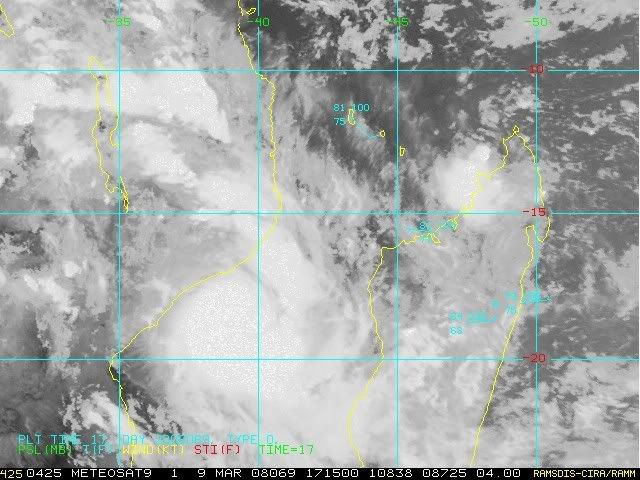
Re: Mozambique Channel: Tropical Cyclone Jokwe (TC 22S)
ZCZC 676
WTIO30 FMEE 090625
RSMC / TROPICAL CYCLONE CENTRE / LA REUNION
TROPICAL CYCLONE FORECAST WARNING (SOUTH-WEST INDIAN OCEAN)
0.A WARNING NUMBER : 19/12/20072008
1.A SEVERE TROPICAL STORM 12 (JOKWE)
2.A POSITION 2008/03/09 AT 0600 UTC :
WITHIN 30 NM RADIUS OF POINT 17.6S / 39.1E
(SEVENTEEN DECIMAL SIX DEGREES SOUTH AND THIRTY NINE DECIMAL ONE
DEGREES
EAST)
3.A DVORAK ANALYSIS : 3.5/4.0 /W 1.0/6 H
4.A CENTRAL PRESSURE : 983 HPA
5.A MAX AVERAGE WIND SPEED (10 MN) : 60 KT
6.A EXTENSION OF WINDS BY QUADRANTS (KM):
30 KT NE: 180 SE: 200 SO: 130 NO: 180
50 KT NE: 050 SE: 050 SO: 050 NO: 050
7.A FIRST CLOSED ISOBARE (PRESSURE / AVERAGE DIAM): 1008 HPA / 600 KM
8.A VERTICAL EXTENSION OF CYCLONE CIRCULATION: DEEP
1.B FORECASTS:
12H: 2008/03/09 18 UTC: 18.6S/38.9E, MAX WIND=060KT, SEVERE TROP.
STORM.
24H: 2008/03/10 06 UTC: 19.9S/39.1E, MAX WIND=070KT, TROPICAL
CYCLONE.
36H: 2008/03/10 18 UTC: 21.4S/39.3E, MAX WIND=080KT, TROPICAL
CYCLONE.
48H: 2008/03/11 06 UTC: 22.9S/39.5E, MAX WIND=070KT, TROPICAL
CYCLONE.
60H: 2008/03/11 18 UTC: 24.1S/39.5E, MAX WIND=060KT, SEVERE TROP.
STORM.
72H: 2008/03/12 06 UTC: 25.1S/39.6E, MAX WIND=050KT, SEVERE TROP.
STORM.
2.B OTHER INFORMATIONS:
T=3.5 CI=4.0
STRONG WEAKENING HAS OCCURED AS THE THE SYSTEM HAS INTERACT WITH
LAND. IT
IS EXPECTED TO KEEP ON TRACKING GENERALLY SOUTHWARDS . ENVIRONMENT
SHOULD THEN ALLOW THE SYSTEM TO REINTENSIFY, BEEING AGAIN COMPLETLY
OVER
SEAS.
IT IS EXPECTED TO WEAKEN UNDERGOING A INCREASING VERTICAL WIND SHEAR
BEYONG TAU 48.
MSLP IS HIGHER THAN USUAL FOR THIS INTENSITY STAGE DUE TO THE SMALL
SIZE
OF THE SYSTEM.=
NNNN
0 likes


Re: Mozambique Channel: Severe Tropical Storm Jokwe (TC 22S)
Cyclone Jokwe flays Mozambique, one killed
Sun 9 Mar 2008, 15:24 GMT
MAPUTO (Reuters) - Tropical cyclone Jokwe lashed northern Mozambique on Sunday, killing at least one person and destroying over 500 homes, a meteorological official said.
Mussa Mustafa, head of Mozambique's National Meteorological Institute, said the cyclone which swept through part of Madagascar last week, is expected to intensify by Monday.
"Our (meteorological) colleagues in the coastal district of Angoche reported that one person died when his house collapsed, and we also have a number of houses which have been extensively damaged there", Mustafa told Reuters.
Radio Mozambique reported that scores of people have fled their homes in the northern Nampula Province and national television broadcast footage of electricity pylons brought down by strong winds of up to 200 kph (125 miles).
Mustafa said the risk of renewed flooding was small because the rains would hit coastal areas and flow into the ocean.
Tens of thousands of people in Mozambique were forced to flee their homes earlier this year in what the United Nations said could be the worst floods in memory, engulfing farmland and wrecking roads and bridges.
Last month Cyclone Ivan smashed Madagascar, killing more than 80 people and leaving over 200,000 homeless, but lost steam before striking Mozambique.
© Reuters 2008.
0 likes


Who is online
Users browsing this forum: No registered users and 66 guests