Erin NHC Report is up (Read it on page 3)
Moderator: S2k Moderators
Forum rules

The posts in this forum are NOT official forecasts and should not be used as such. They are just the opinion of the poster and may or may not be backed by sound meteorological data. They are NOT endorsed by any professional institution or STORM2K. For official information, please refer to products from the National Hurricane Center and National Weather Service.
-
Squarethecircle
- Category 5

- Posts: 2165
- Joined: Fri Oct 19, 2007 4:00 pm
- Location: Fairfax, VA
-
Derek Ortt
it was technically a tropical depression, then a subtropical depression (once back over the GOM), then a subtropical storm (over Mississippi), then back to STD (over Georgia), then finally again STS off of Delaware
They still are TCs or STCswhen HPS issues advisories. The only thing different is that HPC not NHC is issuing the advisories
They still are TCs or STCswhen HPS issues advisories. The only thing different is that HPC not NHC is issuing the advisories
0 likes

Re: Final Best-Track: Erin 50 kts LOW inland
HurricaneRobert wrote:I don't think that's the "final" say since its been almost two weeks and the TCR is still not out.
They won't issue the map unless it's final. Other things could be delaying the TCR.
0 likes
-
Coredesat
Re:
Derek Ortt wrote:it was technically a tropical depression, then a subtropical depression (once back over the GOM), then a subtropical storm (over Mississippi), then back to STD (over Georgia), then finally again STS off of Delaware
They still are TCs or STCswhen HPS issues advisories. The only thing different is that HPC not NHC is issuing the advisories
Well, the NHC apparently has the final say in the matter since they're the ones who actually write the TCR and compile the best track. I really don't think this should be the case - I think HPC should be allowed to operationally upgrade something if obs indicate it should be upgraded; in its current state it's practically an undesignated TCWC.
0 likes
-
HurricaneRobert
- Category 3

- Posts: 812
- Joined: Fri May 18, 2007 9:31 pm
-
Hurricanehink

- S2K Supporter

- Posts: 2046
- Joined: Sun Nov 16, 2003 2:05 pm
- Location: New Jersey
Re: Final Best-Track: Erin 50 kts LOW inland
http://www.nhc.noaa.gov/tracks1851to2007_atl_reanal.txt
This hasn't been posted yet, but the 2007 AHS was added to the best track, and Erin is indeed listed as a 50 kt low.
This hasn't been posted yet, but the 2007 AHS was added to the best track, and Erin is indeed listed as a 50 kt low.
0 likes

-
CrazyC83
- Professional-Met

- Posts: 34308
- Joined: Tue Mar 07, 2006 11:57 pm
- Location: Deep South, for the first time!
Re:
Derek Ortt wrote:maybe there is some opposition to a 50KT low
That's probably why - there must be considerable dispute at the NHC. They must have had it ready and then someone called for another review. Depending on who you ask, you could call it a remnant low, extratropical, a subtropical storm (which I think it was) or a tropical storm at that point.
0 likes

Re: Re:
CrazyC83 wrote:Derek Ortt wrote:maybe there is some opposition to a 50KT low
That's probably why - there must be considerable dispute at the NHC. They must have had it ready and then someone called for another review. Depending on who you ask, you could call it a remnant low, extratropical, a subtropical storm (which I think it was) or a tropical storm at that point.
No, not likely. The track map and the data base would not have been issued if the status of Erin had not been finalized.
0 likes
-
MiamiensisWx
Re: Final Best-Track: Erin 50 kts LOW inland
I think it will probably be listed as a MCS (Mesoscale Convective System) over OK in the TCR. That would explain the "remnant low" designation in HURDAT, which doesn't list systems as Mesoscale Convective Systems. Personally, I think it's a valid classification, since it didn't fit the available definitions of a tropical/convective system or a remnant (non-convective) low. It could've been subtropical, but I have tended to lean toward an MCS, since that fits available data. Apparently, they couldn't utilize "landcane" or "landphoon" for the system...
The TCR should be released within the next several days.
The TCR should be released within the next several days.
0 likes
-
brunota2003

- S2K Supporter
- Posts: 9476
- Age: 35
- Joined: Sat Jul 30, 2005 9:56 pm
- Location: Stanton, KY...formerly Havelock, NC
- Contact:
Was reading the 2007 Hurricane Season in review for the Atlantic (which was written by a couple forecasters recently for the AMS Weatherwise). The reasoning was that the low pressure did not have convection long enough to be considered a true tropical cyclone (the convection was forced by a frontal system, and the convection died down as soon as the greatest forcing passed by). It was not tropical, nor was it extratropical or subtropical. It was not attached to any frontal boundaries, so therefore it was just a "low".
That is as best as I can remember how they put it (though, the article was a very interesting read).
That is as best as I can remember how they put it (though, the article was a very interesting read).
0 likes
-
CrazyC83
- Professional-Met
- Posts: 34308
- Joined: Tue Mar 07, 2006 11:57 pm
- Location: Deep South, for the first time!
Re: Final Best-Track: Erin 50 kts LOW inland
Courtesy of the NHC Review at the WMO meeting site:
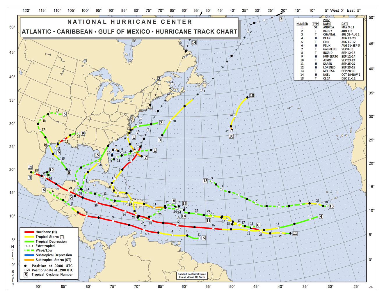
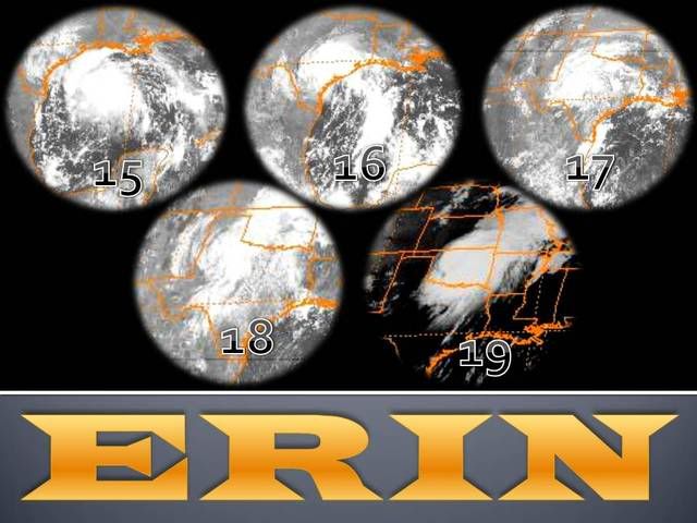
Tropical Storm Erin formed over the Gulf of Mexico in association with a tropical wave very early on 15 August while centered roughly 430 miles east-southeast of Brownsville, Texas. Moving northwestward to the south of a deep-layer ridge over the southern United States, the depression became a tropical storm with maximum winds of 40 mph later that day. Bands of heavy rain began moving ashore along nearly the entire coast of Texas at about that time. Erin did not strengthen any further over the Gulf, and it barely maintained tropical storm status early on 16 August. Erin made landfall on San Jose Island, Texas (about 35 miles east-northeast of Corpus Christi) later that day, but by that time it had weakened to a depression with maximum winds of 35 mph. The depression continued northwestward and inland. The circulation remained intact, but the system was no longer a tropical cyclone by 17 August when it was located about 60 miles south of San Angelo, Texas. The low turned northward over extreme western Texas on 18 August around the western periphery of the ridge over the southeastern United States. Upon reaching the northwestern extent of the ridge, the low turned northeastward into southwestern Oklahoma very early on 19 August. The low had produced some heavy rainfall during the preceding 36 hours, but the convection was not sufficiently persistent and organized to continue to designate the system as a tropical depression.
When the surface low moved east-northeastward over Oklahoma early on 19 August, thunderstorm activity abruptly increased as the low interacted with an eastward-moving upper-level shortwave trough. During an approximately six-hour period, sustained winds of gale force were observed at several locations in western and central Oklahoma (as strong as about 60 mph), with isolated gusts of hurricane force (as strong as 82 mph). The system’s organization also briefly became dramatically enhanced, with an eye-like feature readily discernible in WSR-88D radar imagery for about five hours. This episode was short-lived, however, and the eye-like feature quickly dissipated thereafter. The thunderstorm activity and strong winds had already begun to weaken by that time, as the upper-level shortwave trough proceeded eastward and away from the surface low. The surface circulation dissipated late on 19 August over northeastern Oklahoma, but remnant moisture continued northeastward into Missouri.
While the system's structure, particularly its convective organization as seen on radar, resembled and had some characteristics of a tropical or subtropical storm for a few hours on 19 August, the prevailing view from the National Hurricane Center's Hurricane Specialists is that the system was not a tropical or subtropical cyclone over Oklahoma. While it is a subjective
determination, in this case the deep convection is judged to have lasted an insufficient period of time to classify the system as a tropical or subtropical cyclone. The limited duration of the convection also appears to be indicative of the physical mechanisms that caused the low to briefly strengthen. It is speculated that the upper-level shortwave trough forced the deep convection to increase via upper-level difluence, while briefly superimposed above the surface low that provided a focus for low-level confluence. The upper-level forcing was apparently a dominant mechanism, which is in contrast to tropical cyclones that are maintained primarily by extraction of heat energy from the ocean. Since the system was clearly non-frontal over Oklahoma, designating it as an extratropical cyclone is also not the most appropriate solution. Given all of these considerations, the system is simply designated as a “low” by NHC on 19 August.
Erin and its remnants brought heavy rains to many portions of Texas and Oklahoma, and portions of southern Missouri, directly causing 16 fatalities, nine of which occurred while Erin was still a tropical cyclone. Significant damages occurred on 19 August in some communities northwest of Oklahoma City, where several homes were flooded, and strong winds damaged some mobile homes and downed several trees and power lines.
http://www.wmo.int/pages/prog/www/tcp/M ... oc.4.E.doc
0 likes
-
CrazyC83
- Professional-Met
- Posts: 34308
- Joined: Tue Mar 07, 2006 11:57 pm
- Location: Deep South, for the first time!
I'm thinking that was part of the TCR that was about to be released but some at the NHC had serious disagreements and they decided to take it back for review.
Calling it a tropical or subtropical storm over land has precedence - Allison in 2001 was re-classified as such over central Mississippi (although only at 40 kt).
Calling it a tropical or subtropical storm over land has precedence - Allison in 2001 was re-classified as such over central Mississippi (although only at 40 kt).
0 likes
-
Derek Ortt
-
CrazyC83
- Professional-Met
- Posts: 34308
- Joined: Tue Mar 07, 2006 11:57 pm
- Location: Deep South, for the first time!
Re:
Derek Ortt wrote:it is not really settled yet
for the record, this scientist firmly believes it was a TS over Oklahoma. It was a baroclinically enhanced TC, just like Charley and Wilma were when they devastated Florida
I'm not a scientist, but I think it was a subtropical storm - the fact that it had a well-defined circulation and was not frontal, but lacked the continuous deep convection. (I think it became a subtropical depression just after landfall and maintained itself as an STC until it was absorbed in the Ozarks).
0 likes
-
Ed Mahmoud
Re: Final Best-Track: Erin 50 kts LOW inland
Lot of rain here with that one, whereas Humberto, by the time it was named, despite passing fairly close to the HOU area, didn't rain on us at all. All of the rain fell pre-Humberto.
0 likes
-
HurricaneRobert
- Category 3
- Posts: 812
- Joined: Fri May 18, 2007 9:31 pm
Re: Final Best-Track: Erin 50 kts LOW inland
Ed Mahmoud wrote:Lot of rain here with that one, whereas Humberto, by the time it was named, despite passing fairly close to the HOU area, didn't rain on us at all. All of the rain fell pre-Humberto.
Since it made landfall on High Island, it was in the Houston-Galveston metro area, making it the first hurricane to hit Houston without anyone noticing.
0 likes
Who is online
Users browsing this forum: No registered users and 106 guests