Another week of severe weather in the southern plains?

U.S. & Caribbean Weather Discussions and Severe Weather Events

Moderator: S2k Moderators

Forum rules

The posts in this forum are NOT official forecast and should not be used as such. They are just the opinion of the poster and may or may not be backed by sound meteorological data. They are NOT endorsed by any professional institution or STORM2K.

Help Support Storm2K
Message
Author
RL3AO
Moderator-Pro Met
Moderator-Pro Met
Posts: 16308
Joined: Thu Jun 14, 2007 10:03 pm
Location: NC

Re: Another week of severe weather in the southern plains?

#21 Postby RL3AO » Sat Apr 05, 2008 7:52 pm

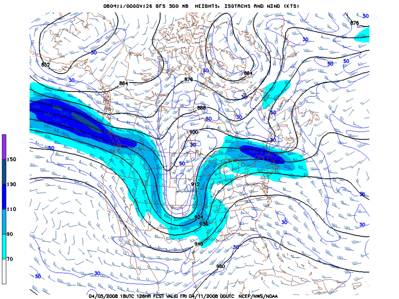
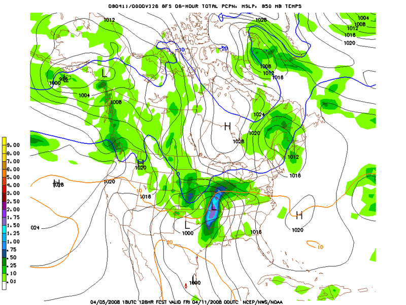
The jet is pretty strong, but I'm not sure how much moisture will be there.

Image
Image


I'm sure Ed and Crazy will be along soon with a much deeper breakdown. :D
0 likes   

Ed Mahmoud

Re: Another week of severe weather in the southern plains?

#22 Postby Ed Mahmoud » Sat Apr 05, 2008 8:44 pm

Both the met.utah.edu and the NIU.edu weather servers, my favorite places for severe stuff, are down today. I can look at AccuWx's PPV stuff, but I can't link or image it here.
0 likes   

CrazyC83
Professional-Met
Professional-Met
Posts: 34002
Joined: Tue Mar 07, 2006 11:57 pm
Location: Deep South, for the first time!

Re: Another week of severe weather in the southern plains?

#23 Postby CrazyC83 » Sat Apr 05, 2008 9:06 pm

Ed Mahmoud wrote:Only the SWODY1 actually breaks out the individual modes of severe weather for probabilities, although the SWODY2 and SWODY3 will sometimes mention tornado or hail threats.


When a major outbreak is possible, by Day 3 there will often be mention of it - and sometimes strong wording.

I do think that they should introduce (at least on an experimental basis) a tornado-specific Day 2 forecast (with the current one remaining for all severe weather). The other changes I would make are in the categorization: a 30% tornado not hatched (rare) should be a MDT, not a HIGH in my opinion.
0 likes   

Ed Mahmoud

Re: Another week of severe weather in the southern plains?

#24 Postby Ed Mahmoud » Sat Apr 05, 2008 9:29 pm

18Z WRF (looking at AccuWx) dryline just West of DFW area Monday at 7 pm, with storms just starting to break out. CAPE an impressive 3000 Joules/Kg around Metroplex, deep layer shear 50 knots, although surface winds are a tad light, 10 knots, best EHI (combination of shear and instability) across the Red River in Southern Oklahoma. More a hail threat around DFW, tornadoes are more likely around the I-35 corridor in Oklahoma South of OKC.

WRF suggests more severe weather for North Central Texas Tuesday afternoon, maybe a tad further West than Monday, but the Big Show would be Southern Missouri, much of Arkansas, Western Tennesee and Northern Mississippi.


No pictures or links, just gotta trust me.


Don't know what is wrong with the met.utah.edu site or the Northern Illinois U 'Storm Machine'. My two favorite sites, down on the same day.
0 likes   

RL3AO
Moderator-Pro Met
Moderator-Pro Met
Posts: 16308
Joined: Thu Jun 14, 2007 10:03 pm
Location: NC

#25 Postby RL3AO » Sat Apr 05, 2008 9:30 pm

You could always take a screenshot and edit with MS Paint to get the image you are looking at. Then upload to photoshop.


*hint*hint* :D
0 likes   

Ed Mahmoud

Re:

#26 Postby Ed Mahmoud » Sat Apr 05, 2008 9:45 pm

RL3AO wrote:You could always take a screenshot and edit with MS Paint to get the image you are looking at. Then upload to photoshop.


*hint*hint* :D


That is a lot of work, and, technically, a violation of my user agreement with AccuWx.


I started a thread about pro-mets not visiting, because on the hurricane threads, the pro-mets could post model and data images I don't think are readily available to the general public on the world wide interweb.
0 likes   

CrazyC83
Professional-Met
Professional-Met
Posts: 34002
Joined: Tue Mar 07, 2006 11:57 pm
Location: Deep South, for the first time!

Re: Another week of severe weather in the southern plains?

#27 Postby CrazyC83 » Sun Apr 06, 2008 9:36 am

ZCZC SPCSWOD48 ALL
ACUS48 KWNS 060903
SPC AC 060903

DAY 4-8 CONVECTIVE OUTLOOK
NWS STORM PREDICTION CENTER NORMAN OK
0403 AM CDT SUN APR 06 2008

VALID 091200Z - 141200Z

...DISCUSSION...
AN ACTIVE MIDDLE OF THE WEEK IS EXPECTED ACROSS THE SOUTHERN PLAINS
INTO THE MID SOUTH REGION/MIDDLE MISSISSIPPI VALLEY
. ALTHOUGH
TIMING/AMPLITUDE UNCERTAINTIES INHERENTLY EXIST...LATEST 00Z
GFS/ECMWF/MREF ARE IN RELATIVELY GOOD AGREEMENT THAT AN UPPER TROUGH
WILL AMPLIFY/SHIFT EASTWARD ACROSS THE SOUTHWEST STATES/SOUTHERN
ROCKIES TUESDAY INTO WEDNESDAY. AHEAD OF THIS POTENTIALLY POTENT
SYSTEM...A RESERVOIR OF MODIFIED GULF MOISTURE IS EXPECTED TO LINGER
ACROSS TX THROUGH THE EARLY PART OF THIS WEEK. THIS SCENARIO WILL
ALLOW A RELATIVELY RICH MOISTURE SUPPLY TO EFFECTIVELY ADVECT
NORTH-NORTHEASTWARD ACROSS THE PLAINS/MISSISSIPPI VALLEY BY THE
MIDDLE OF THE WEEK. IN ALL...OWING TO THE LIKLIHOOD OF MODERATE TO
STRONG VERTICAL SHEAR ATOP A MOIST/UNSTABLE AIRMASS...MODEL
CONSENSUS IMPLIES THAT SEVERE STORMS/SUPERCELLS ARE LIKELY ACROSS
MUCH OF TX INTO OK ON DAY 4 WEDNESDAY/WEDNESDAY NIGHT
. AS THE UPPER
TROUGH/SURFACE LOW CONTINUES TO ADVANCE NORTHEASTWARD ACROSS THE
MIDWEST ON DAY 5/THURSDAY...A BROAD COVERAGE OF SEVERE STORMS IS
DISTINCTLY POSSIBLE
ON THURSDAY DAY 5 ACROSS THE MID
SOUTH/OZARKS/MIDDLE MISSISSIPPI VALLEY.

..GUYER.. 04/06/2008

CLICK TO GET WUUS48 PTSD48 PRODUCT
0 likes   

RL3AO
Moderator-Pro Met
Moderator-Pro Met
Posts: 16308
Joined: Thu Jun 14, 2007 10:03 pm
Location: NC

#28 Postby RL3AO » Sun Apr 06, 2008 12:22 pm

Also have a 30 hatched area for tomorrow, mainly in Oklahoma.
0 likes   

RL3AO
Moderator-Pro Met
Moderator-Pro Met
Posts: 16308
Joined: Thu Jun 14, 2007 10:03 pm
Location: NC

#29 Postby RL3AO » Sun Apr 06, 2008 12:57 pm

Just looked through the day two outlook. There are some questions on weather some elevated storms will develop tomorrow morning and afternoon and limit the instability. They also said this at the end.

SHOULD AIR MASS DESTABILIZE AS IS CURRENTLY FORECAST AND
DISCRETE...DIURNAL TSTM DEVELOPMENT OCCUR IN SYSTEM WARM
SECTOR...THE POTENTIAL WILL EXIST FOR A CLUSTER TORNADO EVENT ACROSS
OK MONDAY AFTERNOON INTO EVENING. AS SUCH...AN UPGRADE TO MODERATE
RISK MAY BECOME NECESSARY IN SUBSEQUENT DAY ONE OUTLOOKS ONCE
FINER-SCALE DETAILS BECOME MORE CLEAR.
0 likes   

JonathanBelles
Professional-Met
Professional-Met
Posts: 11430
Age: 35
Joined: Sat Dec 24, 2005 9:00 pm
Location: School: Florida State University (Tallahassee, FL) Home: St. Petersburg, Florida
Contact:

#30 Postby JonathanBelles » Sun Apr 06, 2008 1:00 pm

CLUSTER TORNADO EVENT??

What is that?
When a bunch of tornadoes move together?
0 likes   

RL3AO
Moderator-Pro Met
Moderator-Pro Met
Posts: 16308
Joined: Thu Jun 14, 2007 10:03 pm
Location: NC

Re:

#31 Postby RL3AO » Sun Apr 06, 2008 1:05 pm

fact789 wrote:CLUSTER TORNADO EVENT??

What is that?
When a bunch of tornadoes move together?


My guess would be a decent number of tornadoes in a relatively small area.

Maybe something like you see in SW Missouri here.

Image

Just a guess though.
0 likes   

Ed Mahmoud

Re: Another week of severe weather in the southern plains?

#32 Postby Ed Mahmoud » Sun Apr 06, 2008 1:16 pm

Southern Oklahoma may have more coverage of the relatively isolated storms tomorrow afternoon/evening.
Image

And I know the local vorticity near the warm front is a favored location for tornadoes, but I'd extend the risk down to DFW based on the forecast sounding on the WRF. There is a cap, but it is breakable, and the best combination of instability and shear is closer to Dallas. If the WRF is correct, that is.

Image
0 likes   

Ed Mahmoud

Re: Another week of severe weather in the southern plains?

#33 Postby Ed Mahmoud » Sun Apr 06, 2008 3:55 pm

Snips from NWS FWD AFD

THE MODEL CONSENSUS CONTINUES TO SUGGEST A GREAT DEAL OF
UNCERTAINTY REGARDING THE PROSPECTS FOR CONVECTIVE INITIATION ALONG
THE DRY LINE LATE TOMORROW AFTERNOON. NAM/ECMWF ARE THE ONLY
MODELS THAT HAVE CONSISTENTLY OUTPUT QPF...WHILE THE OTHER MODELS
REMAIN DRY. THE MODELS DO CONCUR THAT A VERY UNSTABLE AND
MODERATELY SHEARED AIRMASS WILL DEVELOP OVER NORTH TEXAS DURING
THE DAY...WITH ONLY WEAK DYNAMIC FORCING AVAILABLE TO BREAK THE
CAP. THIS SUGGESTS THAT STORMS WILL BE ISOLATED AT BEST SOUTH OF
THE RED RIVER. HOWEVER ANY STORM THAT DOES DEVELOP WILL BECOME
SUPERCELLULAR AND POSES A RISK OF VERY LARGE HAIL...DAMAGING WINDS
AND AN ISOLATED TORNADO. WILL HAVE THE HIGHEST POPS -STILL ONLY
30 PERCENT- OVER THE NW CWA WHERE INITIATION POTENTIAL IS BEST.
............snip.................................................

INTENSIFYING SOUTHERLY LOW LEVEL
JET IN EXCESS OF 50KT WILL TRANSPORT RICH GULF MOISTURE INTO THE
REGION WEDNESDAY. STRONG LIFT AHEAD OF THE UPPER TROUGH WILL BE
AUGMENTED BY THE LINGERING BAROCLINIC ZONE. SCATTERED TO NUMEROUS
THUNDERSTORMS ARE EXPECTED OVER THE AREA WEDNESDAY AFTERNOON
THROUGH THURSDAY MORNING. THREAT OF SEVERE WEATHER AND HEAVY
RAINFALL WILL EXIST OVER MUCH OF NORTH TEXAS DURING THIS TIME
FRAME...WITH COMBINATION OF LOW LEVEL SHEAR/INSTABILITY POINTING
TOWARD A POSSIBLE OUTBREAK.

0 likes   

User avatar
zaqxsw75050
Tropical Storm
Tropical Storm
Posts: 178
Joined: Thu Mar 06, 2008 4:21 pm
Location: Hong Kong

Re: Another week of severe weather in the southern plains?

#34 Postby zaqxsw75050 » Sun Apr 06, 2008 4:09 pm

Ed Mahmoud wrote:Snips from NWS FWD AFD

THE MODEL CONSENSUS CONTINUES TO SUGGEST A GREAT DEAL OF
UNCERTAINTY REGARDING THE PROSPECTS FOR CONVECTIVE INITIATION ALONG
THE DRY LINE LATE TOMORROW AFTERNOON. NAM/ECMWF ARE THE ONLY
MODELS THAT HAVE CONSISTENTLY OUTPUT QPF...WHILE THE OTHER MODELS
REMAIN DRY. THE MODELS DO CONCUR THAT A VERY UNSTABLE AND
MODERATELY SHEARED AIRMASS WILL DEVELOP OVER NORTH TEXAS DURING
THE DAY...WITH ONLY WEAK DYNAMIC FORCING AVAILABLE TO BREAK THE
CAP. THIS SUGGESTS THAT STORMS WILL BE ISOLATED AT BEST SOUTH OF
THE RED RIVER. HOWEVER ANY STORM THAT DOES DEVELOP WILL BECOME
SUPERCELLULAR AND POSES A RISK OF VERY LARGE HAIL...DAMAGING WINDS
AND AN ISOLATED TORNADO. WILL HAVE THE HIGHEST POPS -STILL ONLY
30 PERCENT- OVER THE NW CWA WHERE INITIATION POTENTIAL IS BEST.
............snip.................................................

INTENSIFYING SOUTHERLY LOW LEVEL
JET IN EXCESS OF 50KT WILL TRANSPORT RICH GULF MOISTURE INTO THE
REGION WEDNESDAY. STRONG LIFT AHEAD OF THE UPPER TROUGH WILL BE
AUGMENTED BY THE LINGERING BAROCLINIC ZONE. SCATTERED TO NUMEROUS
THUNDERSTORMS ARE EXPECTED OVER THE AREA WEDNESDAY AFTERNOON
THROUGH THURSDAY MORNING. THREAT OF SEVERE WEATHER AND HEAVY
RAINFALL WILL EXIST OVER MUCH OF NORTH TEXAS DURING THIS TIME
FRAME...WITH COMBINATION OF LOW LEVEL SHEAR/INSTABILITY POINTING
TOWARD A POSSIBLE OUTBREAK.


wow... very strong word from FWD office...
0 likes   

RL3AO
Moderator-Pro Met
Moderator-Pro Met
Posts: 16308
Joined: Thu Jun 14, 2007 10:03 pm
Location: NC

#35 Postby RL3AO » Sun Apr 06, 2008 5:39 pm

GFS looks nasty for Thursday. Starts with the low around Dallas and finishes near Chicago at 990mb.
0 likes   

User avatar
Bunkertor
Category 5
Category 5
Posts: 3397
Joined: Tue May 09, 2006 3:48 pm

#36 Postby Bunkertor » Sun Apr 06, 2008 6:59 pm

What i learned 2008. Things don´t develop as predicted...
0 likes   

RL3AO
Moderator-Pro Met
Moderator-Pro Met
Posts: 16308
Joined: Thu Jun 14, 2007 10:03 pm
Location: NC

Re:

#37 Postby RL3AO » Sun Apr 06, 2008 7:03 pm

Bunkertor wrote:What i learned 2008. Things don´t develop as predicted...


Feb 5 was pretty much nailed by the models 7 days out.
0 likes   

User avatar
Bunkertor
Category 5
Category 5
Posts: 3397
Joined: Tue May 09, 2006 3:48 pm

Re: Re:

#38 Postby Bunkertor » Sun Apr 06, 2008 7:22 pm

RL3AO wrote:
Bunkertor wrote:What i learned 2008. Things don´t develop as predicted...


Feb 5 was pretty much nailed by the models 7 days out.


Can´t remember the Feb right now. Just had that feeling due to late/missing PDS for example... but mostly SPC does an awesome job.
0 likes   

User avatar
wx247
S2K Supporter
S2K Supporter
Posts: 14279
Age: 41
Joined: Wed Feb 05, 2003 10:35 pm
Location: Monett, Missouri
Contact:

#39 Postby wx247 » Sun Apr 06, 2008 9:18 pm

I am not looking forward to this week. It has been a crazy year so far here in SW Missouri. If we have anything close to what happened in the storm reports referenced above in January, I may permanently live in my basement. I know isobar calls me the "Tornado Magnet" but this is rediculous.
0 likes   

Ed Mahmoud

Re: Another week of severe weather in the southern plains?

#40 Postby Ed Mahmoud » Mon Apr 07, 2008 8:17 am

Hatched on the SWODY3. Don't see that everyday.
0 likes   


Return to “USA & Caribbean Weather”

Who is online

Users browsing this forum: snownado, TomballEd and 28 guests