Wed., 9th of April 08 till Friday 11th outbreak-thread
Moderator: S2k Moderators
Forum rules

The posts in this forum are NOT official forecast and should not be used as such. They are just the opinion of the poster and may or may not be backed by sound meteorological data. They are NOT endorsed by any professional institution or STORM2K.

-
CrazyC83
- Professional-Met

- Posts: 34315
- Joined: Tue Mar 07, 2006 11:57 pm
- Location: Deep South, for the first time!
Re:
RL3AO wrote:After that PDS they pulled off a few days ago, you would figure this one would be.
Depends on who is at the desk right now.
The last PDS was based on a condition that dewpoints increased more (which they didn't) since they mentioned a few degrees would turn isolated supercells into an outbreak.
Last edited by CrazyC83 on Wed Apr 09, 2008 12:53 pm, edited 1 time in total.
0 likes
-
CrazyC83
- Professional-Met
- Posts: 34315
- Joined: Tue Mar 07, 2006 11:57 pm
- Location: Deep South, for the first time!
Re:
RL3AO wrote:I think it will be. It is a very strongly worded MD.
I think so too, but I wouldn't be shocked either way. It is a 15H tornado area, which gives it more justification.
0 likes
-
6SpeedTA95
- Category 5

- Posts: 1206
- Joined: Wed Oct 19, 2005 3:25 pm
- Location: Oklahoma
- Contact:


Re: Wed., 9th of April 08 till Saturday 12th outbreak-thread
Mansfield, just south of Dallas is at 67 dew points at 63. The temperature here rose 7 degrees in an hour....
0 likes
-
Ed Mahmoud
Re: Wed., 9th of April 08 till Saturday 12th outbreak-thread
Clearing and already 80ºF (26.7ºC) in San Angelo, and winds shifting to Southeast at Abilene, so front is almost there. Dewpoint 63ºF (17ºC). 3 mb pressure drop, to 1005 mb, in last 3 hours, 24 mph winds (39 km/hr) with higher gusts suggests good wind energy.
So it should destabilize nicely South of the front now that the clouds are starting to break.
So it should destabilize nicely South of the front now that the clouds are starting to break.
0 likes

Re: Wed., 9th of April 08 till Saturday 12th outbreak-thread
CrazyC83 wrote:Bunkertor wrote:CrazyC83 wrote:Really about a 55% chance instead of 45% - some mets wanted to go high:
How can you know that. Has there been a radio report ?
The Day 2 outlook mentions that there was serious discussion of going high risk (and on a day 2, that requires a 60% hatched area).
OK, i read that, too, but first when Day 2 was issued. Thought you had some insider sources.
0 likes
Re: Wed., 9th of April 08 till Saturday 12th outbreak-thread
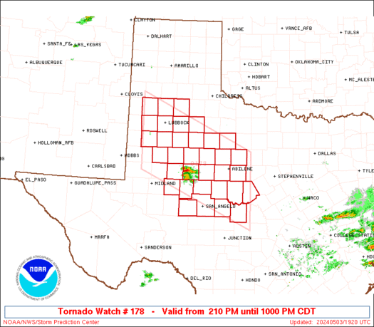
URGENT - IMMEDIATE BROADCAST REQUESTED
TORNADO WATCH NUMBER 178
NWS STORM PREDICTION CENTER NORMAN OK
120 PM CDT WED APR 9 2008
THE NWS STORM PREDICTION CENTER HAS ISSUED A
TORNADO WATCH FOR PORTIONS OF
PARTS OF WEST CENTRAL AND NORTHWEST TEXAS
EFFECTIVE THIS WEDNESDAY AFTERNOON AND EVENING FROM 120 PM UNTIL
800 PM CDT.
...THIS IS A PARTICULARLY DANGEROUS SITUATION...
DESTRUCTIVE TORNADOES...LARGE HAIL TO 3 INCHES IN DIAMETER...
THUNDERSTORM WIND GUSTS TO 80 MPH...AND DANGEROUS LIGHTNING ARE
POSSIBLE IN THESE AREAS.
THE TORNADO WATCH AREA IS APPROXIMATELY ALONG AND 90 STATUTE
MILES NORTH AND SOUTH OF A LINE FROM 70 MILES WEST SOUTHWEST OF
SAN ANGELO TEXAS TO 35 MILES EAST SOUTHEAST OF MINERAL WELLS
TEXAS. FOR A COMPLETE DEPICTION OF THE WATCH SEE THE ASSOCIATED
WATCH OUTLINE UPDATE (WOUS64 KWNS WOU8).
REMEMBER...A TORNADO WATCH MEANS CONDITIONS ARE FAVORABLE FOR
TORNADOES AND SEVERE THUNDERSTORMS IN AND CLOSE TO THE WATCH
AREA. PERSONS IN THESE AREAS SHOULD BE ON THE LOOKOUT FOR
THREATENING WEATHER CONDITIONS AND LISTEN FOR LATER STATEMENTS
AND POSSIBLE WARNINGS.
OTHER WATCH INFORMATION...CONTINUE...WW 176...WW 177...
DISCUSSION...POTENT SHEAR PROFILES ARE NOW IN PLACE TO SUPPORT RAPID
SUPERCELL DEVELOPMENT VICINITY WARM FRONT THAT EXTENDS FROM NEAR MAF
ENEWD TO DFW. MDT/STG WARM SECTOR INSTABILITY WITH LITTLE REMAINING
INHIBITION WRN PORTION OF WATCH WILL LEAD TO RAPID SEVERE
THUNDERSTORM DEVELOPMENT. POTENTIAL FOR VERY LARGE HAIL AND
TORNADOES WITH ANY SUPERCELL. ADDITIONALLY LATER IN AFTERNOON
CONCERN INCREASES FOR STRONG TORNADOES AS SHEAR CONTINUES TO
INCREASE. ADDITIONAL MORE ISOLATED INITIATION IS POSSIBLE DOWN THE
DRY LINE WHICH EXTENDS TO RIO GRANDE BIG BEND.
AVIATION...TORNADOES AND A FEW SEVERE THUNDERSTORMS WITH HAIL
SURFACE AND ALOFT TO 3 INCHES. EXTREME TURBULENCE AND SURFACE
WIND GUSTS TO 70 KNOTS. A FEW CUMULONIMBI WITH MAXIMUM TOPS TO
550. MEAN STORM MOTION VECTOR 24030.
...HALES
0 likes
-
Ed Mahmoud
Re:
Bunkertor wrote:Ed, could you please take a short look over the FDW sounding. What exactly does the temp- and dew lines up to 700mB mean ? In comparrison to AMA and MAF. I´m somehow overworked with that.
The 3 hour RUC sounding in DFW area has limited CAPE, around 300 J/Kg and high CINH because the RUC has DFW area North of warm front.
South of the front, at Brownwood, SBCAPE is over 1000 J/Kg and helicity is fairly high. But DFW may have better tornado chance, because tornadic cells tend to develop on the warm front.

This, of course, is just from the short term RUC model, and may not exactly match actual conditions. Especially as BWD is 75ºF and DFW is 74ºF with South winds.
Models aren't always perfect.
I imagine NWS FWD released an 18Z RAOB at the request of SPC, which often happens in developing situations. I can find the regular 12Z and 0Z soundings on the web (the actual, not the internet soundings), but not special soundings, but I am hoping an AFD will discuss what the 18Z sounding showed.
NWS FWD also has access to ACARS, upper air data from commercial airliners, but that data, at the airlines request, isn't made public, although mention of trends shown by ACARS will show up in AFDs.
0 likes
-
Ed Mahmoud
Re: Wed., 9th of April 08 till Saturday 12th outbreak-thread
CAPE and CINH analysis as of 1 pm CDT. Approximate position of the front is pretty obvious.

0 likes
-
Ed Mahmoud
Re:
0 likes

-
CrazyC83
- Professional-Met
- Posts: 34315
- Joined: Tue Mar 07, 2006 11:57 pm
- Location: Deep South, for the first time!
SPECIAL WEATHER STATEMENT
NATIONAL WEATHER SERVICE MIDLAND/ODESSA TX
211 PM CDT WED APR 9 2008
TXZ048-053-091945-
SCURRY-MITCHELL-
211 PM CDT WED APR 9 2008
...SIGNIFICANT WEATHER ALERT...
THIS SIGNIFICANT WEATHER ALERT IS FOR NORTHEASTERN MITCHELL AND
SOUTHEASTERN SCURRY COUNTIES.
A STRONG THUNDERSTORM WAS LOCATED 5 MILES EAST OF WESTBROOK AT 211 PM
CDT...MOVING NORTHEAST AT 31 MPH. STRONG GUSTY WINDS AND HAIL UP TO
ONE HALF INCH IN SIZE IS POSSIBLE. THIS THUNDERSTORM IS INTENSIFYING
AND COULD BECOME SEVERE. LOCATIONS WHICH COULD BE AFFECTED BY THIS
STORM INCLUDE COLORADO CITY.
A TORNADO WATCH REMAINS IN EFFECT UNTIL 800 PM CDT WEDNESDAY EVENING
FOR WEST TEXAS.
$$
0 likes

The CAPE and helicity are somewhat offset with the former maximized in the southern portion of the watch box and the latter maximized in the northern part of the watch box. They have be to better collocated in order to get strong, long-lived supercells. Otherwise whatever convection that does form in the high CAPE area will quickly become elevated minimizing any threat of tornadic activity.
On a side note, I'm not really a fan of issuing PDS watches if there isn't ongoing activity because of the high bust potential associated with any mesoscale severe weather events. I understand they do have to err on the side of caution but they do not want to overuse their most serious wording for borderline or highly uncertain events.
On a side note, I'm not really a fan of issuing PDS watches if there isn't ongoing activity because of the high bust potential associated with any mesoscale severe weather events. I understand they do have to err on the side of caution but they do not want to overuse their most serious wording for borderline or highly uncertain events.
0 likes
Return to “USA & Caribbean Weather”
Who is online
Users browsing this forum: No registered users and 88 guests