On weatherunderground, currently looks like a -22 against a +5 for rotation.
Touchdown again (or same one):
SEVERE WEATHER STATEMENT
NATIONAL WEATHER SERVICE NEWPORT/MOREHEAD CITY NC
438 PM EDT SUN APR 20 2008
NCC013-147-202115-
/O.CON.KMHX.TO.W.0017.000000T0000Z-080420T2115Z/
PITT NC-BEAUFORT NC-
438 PM EDT SUN APR 20 2008
...A TORNADO WARNING REMAINS IN EFFECT UNTIL 515 PM EDT FOR
NORTHWESTERN BEAUFORT AND EASTERN PITT COUNTIES...
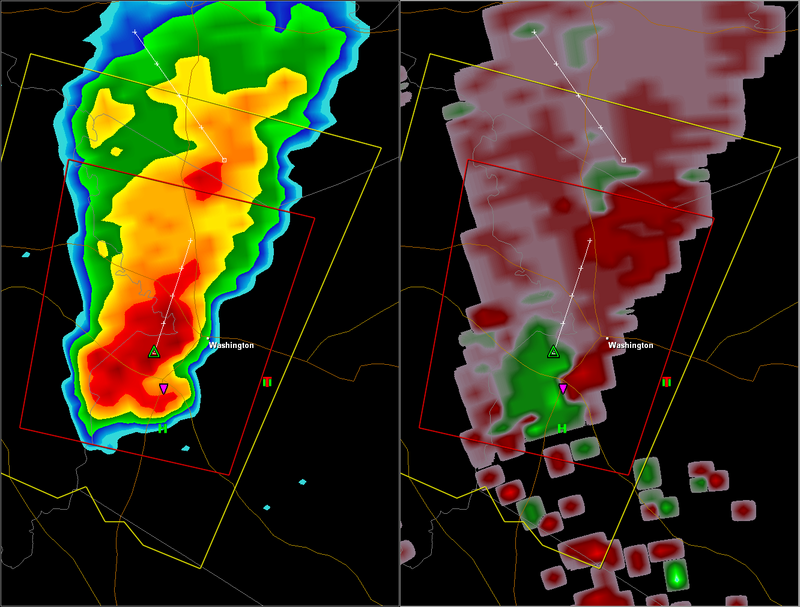
AT 434 PM EDT...THE PUBLIC REPORTED A TORNADO. THIS TORNADO WAS
LOCATED NEAR CHOCOWINITY...OR ABOUT NEAR WASHINGTON...MOVING NORTH AT
13 MPH.
THE TORNADO WILL BE NEAR...
WASHINGTON PARK BY 445 PM EDT...
WASHINGTON AND GRIMESLAND BY 455 PM EDT...
OLD FORD BY 515 PM EDT...
IN ADDITION TO THE TORNADO...THIS STORM IS CAPABLE OF PRODUCING GOLF
BALL SIZE SIZE HAIL AND DESTRUCTIVE STRAIGHT LINE WINDS.
2008 Severe Weather Thread
Moderator: S2k Moderators
Forum rules

The posts in this forum are NOT official forecast and should not be used as such. They are just the opinion of the poster and may or may not be backed by sound meteorological data. They are NOT endorsed by any professional institution or STORM2K.
-
brunota2003

- S2K Supporter

- Posts: 9476
- Age: 35
- Joined: Sat Jul 30, 2005 9:56 pm
- Location: Stanton, KY...formerly Havelock, NC
- Contact:

-
brunota2003
- S2K Supporter
- Posts: 9476
- Age: 35
- Joined: Sat Jul 30, 2005 9:56 pm
- Location: Stanton, KY...formerly Havelock, NC
- Contact:
SEVERE WEATHER STATEMENT
NATIONAL WEATHER SERVICE NEWPORT/MOREHEAD CITY NC
457 PM EDT SUN APR 20 2008
NCC013-147-202115-
/O.CON.KMHX.TO.W.0017.000000T0000Z-080420T2115Z/
PITT NC-BEAUFORT NC-
457 PM EDT SUN APR 20 2008
...A TORNADO WARNING REMAINS IN EFFECT UNTIL 515 PM EDT FOR
NORTHWESTERN BEAUFORT AND EASTERN PITT COUNTIES...
AT 452 PM EDT...THE PUBLIC REPORTED A TORNADO. THIS TORNADO WAS
LOCATED JUST WEST OF WASHINGTON...MOVING NORTH AT 11 MPH.
THE TORNADO WILL BE NEAR...
OLD FORD BY 515 PM EDT...
IN ADDITION TO THE TORNADO...THIS STORM IS CAPABLE OF PRODUCING GOLF
BALL SIZE HAIL AND DESTRUCTIVE STRAIGHT LINE WINDS.
0 likes
-
brunota2003
- S2K Supporter
- Posts: 9476
- Age: 35
- Joined: Sat Jul 30, 2005 9:56 pm
- Location: Stanton, KY...formerly Havelock, NC
- Contact:
Re: 2008 Severe Weather thread
Code: Select all
1945       RIVER ROAD    BEAUFORT    NC   3551    7699   REPORTS OF TORNADO ON THE GROUND NEAR SHADY BANKS (MHX)
2038      CHOCOWINITY    BEAUFORT    NC   3551   7710   NUMEROUS TRAINED SPOTTERS SAW BRIEF TORNADO TOUCH DOWN (MHX)
On a side note, the cell has finally weakened and all warnings for it were dropped (or allowed to expire, rather) at 5:15 pm.
0 likes
BULLETIN - EAS ACTIVATION REQUESTED
TORNADO WARNING
NATIONAL WEATHER SERVICE WAKEFIELD VA
541 PM EDT SUN APR 20 2008
THE NATIONAL WEATHER SERVICE IN WAKEFIELD HAS ISSUED A
* TORNADO WARNING FOR...
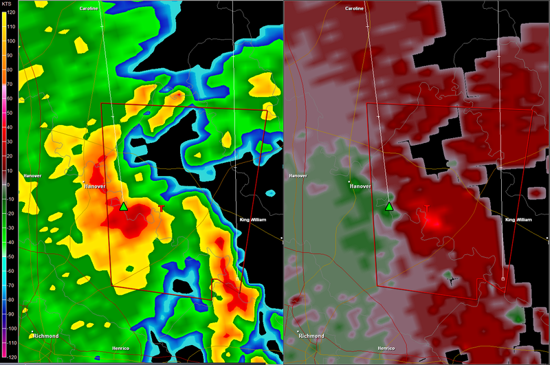
SOUTHEASTERN HANOVER COUNTY IN CENTRAL VIRGINIA...
CENTRAL KING WILLIAM COUNTY IN EAST CENTRAL VIRGINIA...
NORTHWESTERN NEW KENT COUNTY IN EAST CENTRAL VIRGINIA...
* UNTIL 615 PM EDT
* AT 537 PM EDT...NATIONAL WEATHER SERVICE DOPPLER RADAR INDICATED A
SEVERE THUNDERSTORM CAPABLE OF PRODUCING A TORNADO NEAR
TALLEYSVILLE...MOVING NORTH AT 24 MPH.
* THE TORNADO WILL BE NEAR...
TUNSTALL BY 555 PM EDT...
MANQUIN BY 610 PM EDT...
TORNADO WARNING
NATIONAL WEATHER SERVICE WAKEFIELD VA
541 PM EDT SUN APR 20 2008
THE NATIONAL WEATHER SERVICE IN WAKEFIELD HAS ISSUED A
* TORNADO WARNING FOR...
SOUTHEASTERN HANOVER COUNTY IN CENTRAL VIRGINIA...
CENTRAL KING WILLIAM COUNTY IN EAST CENTRAL VIRGINIA...
NORTHWESTERN NEW KENT COUNTY IN EAST CENTRAL VIRGINIA...
* UNTIL 615 PM EDT
* AT 537 PM EDT...NATIONAL WEATHER SERVICE DOPPLER RADAR INDICATED A
SEVERE THUNDERSTORM CAPABLE OF PRODUCING A TORNADO NEAR
TALLEYSVILLE...MOVING NORTH AT 24 MPH.
* THE TORNADO WILL BE NEAR...
TUNSTALL BY 555 PM EDT...
MANQUIN BY 610 PM EDT...
0 likes
BULLETIN - EAS ACTIVATION REQUESTED
TORNADO WARNING
NATIONAL WEATHER SERVICE BALTIMORE MD/WASHINGTON DC
608 PM EDT SUN APR 20 2008
THE NATIONAL WEATHER SERVICE IN STERLING VIRGINIA HAS ISSUED A
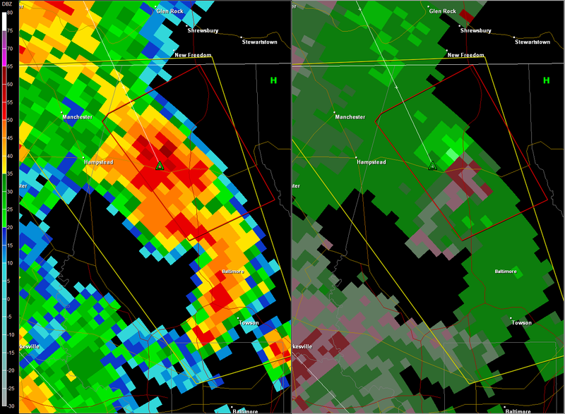
* TORNADO WARNING FOR...
BALTIMORE COUNTY IN NORTHERN MARYLAND
* UNTIL 645 PM EDT
* AT 604 PM EDT...NATIONAL WEATHER SERVICE DOPPLER RADAR INDICATED
A SEVERE THUNDERSTORM WITH STRONG ROTATION NEAR HEREFORD...OR
ABOUT 3 MILES NORTH OF GLENCOE...MOVING NORTHWEST AT 30 MPH.
* LOCATIONS IMPACTED INCLUDE...
HEREFORD...
PARKTON...
BENTLEY SPRINGS...
FREELAND...
TORNADO WARNING
NATIONAL WEATHER SERVICE BALTIMORE MD/WASHINGTON DC
608 PM EDT SUN APR 20 2008
THE NATIONAL WEATHER SERVICE IN STERLING VIRGINIA HAS ISSUED A
* TORNADO WARNING FOR...
BALTIMORE COUNTY IN NORTHERN MARYLAND
* UNTIL 645 PM EDT
* AT 604 PM EDT...NATIONAL WEATHER SERVICE DOPPLER RADAR INDICATED
A SEVERE THUNDERSTORM WITH STRONG ROTATION NEAR HEREFORD...OR
ABOUT 3 MILES NORTH OF GLENCOE...MOVING NORTHWEST AT 30 MPH.
* LOCATIONS IMPACTED INCLUDE...
HEREFORD...
PARKTON...
BENTLEY SPRINGS...
FREELAND...
0 likes
URGENT - IMMEDIATE BROADCAST REQUESTED
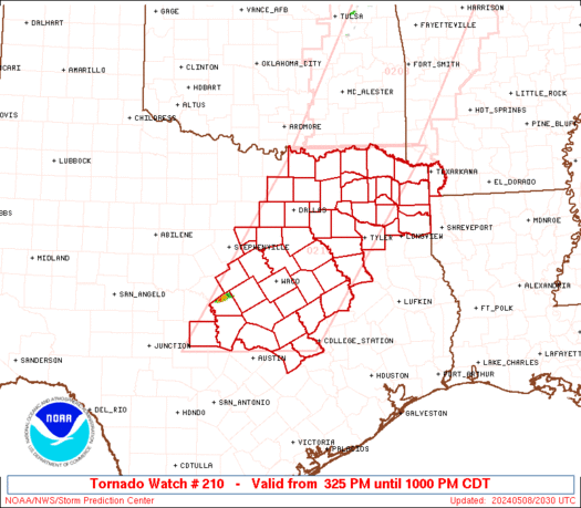
TORNADO WATCH NUMBER 210
NWS STORM PREDICTION CENTER NORMAN OK
800 PM EDT SUN APR 20 2008
THE NWS STORM PREDICTION CENTER HAS ISSUED A
TORNADO WATCH FOR PORTIONS OF
EASTERN NORTH CAROLINA
SOUTHEASTERN VIRGINIA
COASTAL WATERS
EFFECTIVE THIS SUNDAY NIGHT AND MONDAY MORNING FROM 800 PM UNTIL
100 AM EDT.
TORNADOES...HAIL TO 0.5 INCH IN DIAMETER...THUNDERSTORM WIND
GUSTS TO 60 MPH...AND DANGEROUS LIGHTNING ARE POSSIBLE IN THESE
AREAS.
THE TORNADO WATCH AREA IS APPROXIMATELY ALONG AND 50 STATUTE
MILES EAST AND WEST OF A LINE FROM 55 MILES NORTHEAST OF RICHMOND
VIRGINIA TO 50 MILES SOUTHEAST OF NEW BERN NORTH CAROLINA. FOR A
COMPLETE DEPICTION OF THE WATCH SEE THE ASSOCIATED WATCH OUTLINE
UPDATE (WOUS64 KWNS WOU0).
REMEMBER...A TORNADO WATCH MEANS CONDITIONS ARE FAVORABLE FOR
TORNADOES AND SEVERE THUNDERSTORMS IN AND CLOSE TO THE WATCH
AREA. PERSONS IN THESE AREAS SHOULD BE ON THE LOOKOUT FOR
THREATENING WEATHER CONDITIONS AND LISTEN FOR LATER STATEMENTS
AND POSSIBLE WARNINGS.
OTHER WATCH INFORMATION...CONTINUE...WW 209...
DISCUSSION...SHORT BANDS/CLUSTERS OF STORMS WILL CONTINUE ACROSS WW
AREA THROUGH LATE EVENING AS NW NC UPR VORT CONTINUES ESE. NARROW
CURRENT OF MODERATELY MOIST SSELY LOW LEVEL FLOW WILL CONTINUE TO
IMPINGE ON RESIDUAL N/S-ORIENTED OUTFLOW BOUNDARY SEGMENTS FROM
EARLIER STORMS. THIS COULD SUPPORT A CONTINUED THREAT FOR LOW-LEVEL
STORM ROTATION AS TEMP/DEW POINT SPREADS LESSEN...LARGE SCALE ASCENT
STRENGTHENS ...AND STORMS MOVE N ALONG THE BOUNDARIES.
AVIATION...TORNADOES AND A FEW SEVERE THUNDERSTORMS WITH HAIL
SURFACE AND ALOFT TO 0.5 INCH. EXTREME TURBULENCE AND SURFACE
WIND GUSTS TO 50 KNOTS. A FEW CUMULONIMBI WITH MAXIMUM TOPS TO
400. MEAN STORM MOTION VECTOR 18030.
...CORFIDI
0 likes
-
brunota2003
- S2K Supporter
- Posts: 9476
- Age: 35
- Joined: Sat Jul 30, 2005 9:56 pm
- Location: Stanton, KY...formerly Havelock, NC
- Contact:
-
Ed Mahmoud
Re: 2008 Severe Weather thread
SWODY 3 has a 30% area near Wichita Falls, where my immediate supervisor and our geologist will be drilling a well to Pennsylvanian Strawn limestone.
2 weeks ago, our field foreman and a pumper got to witness the tornado that lifted just before Electra from a hill top. There is one little area of ridges and surface relief, but otherwise the land is flat, the mesquite trees are few and far between, and somewhat stunted, and tornado visibility is excellent.
But I shall be stuck in the Houston office.
0 likes
-
Ed Mahmoud
Re: 2008 Severe Weather thread
This should be good for Norman based spotters, SWODY1 update at 8 am CDT has the juiciest part of the SLIGHT RISK just Northwest of OKC, with a 5% tornado and a hatched hail area, and the discussion mentions capping that will keep storms very isolated, but any storms developing on the triple point will have access to very strong instability.
WRF sounding for OKC at 7 pm

Stillwater, I mean.

WRF sounding for OKC at 7 pm
Stillwater, I mean.
0 likes
-
Ed Mahmoud
Re: 2008 Severe Weather thread
GFS still looking favorable (sounding wise) for Norman chases heading North or Northwest a short drive. More a hail sounding than a tornado sounding, but I appreciate a good chase vehicle smashing as much as anyone. Might be different if I actually ever chased, but I don't.

The bad news, the GFS says you'd need to drive to the Kansas state line to actually see any storms.
1630 SWODY 1 looks very similar to 1300 SWODY 1.
The RUC is your friend very close to OKC around 4 pm.

The bad news, the GFS says you'd need to drive to the Kansas state line to actually see any storms.
1630 SWODY 1 looks very similar to 1300 SWODY 1.
The RUC is your friend very close to OKC around 4 pm.
0 likes
-
brunota2003
- S2K Supporter
- Posts: 9476
- Age: 35
- Joined: Sat Jul 30, 2005 9:56 pm
- Location: Stanton, KY...formerly Havelock, NC
- Contact:
My NOAA Wx Radio is going NUTS right now. It has gone off 4 times within the past hour, including twice within the last 5 minutes. These cells are popping up and going crazy as soon as they do, with hail.
SPECIAL WEATHER STATEMENT
NATIONAL WEATHER SERVICE NEWPORT/MOREHEAD CITY NC
212 PM EDT MON APR 21 2008
NCZ029-044-079-080-090>095-098-212015-
MARTIN-PITT-GREENE-BEAUFORT-DUPLIN-LENOIR-JONES-CRAVEN-PAMLICO-
CARTERET-ONSLOW-
INCLUDING THE CITIES OF...WILLIAMSTON...ROBERSONVILLE...
GREENVILLE...SNOW HILL...HOOKERTON...WASHINGTON...RIVER ROAD...
WALLACE...WARSAW...ROSE HILL...KENANSVILLE...BEULAVILLE...
MAGNOLIA...KINSTON...MAYSVILLE...POLLOCKSVILLE...NEW BERN...
HAVELOCK...ORIENTAL...ALLIANCE...BAYBORO...ARAPAHOE...
MINNESOTT BEACH...VANDEMERE...STONEWALL...MOREHEAD CITY...
BEAUFORT...EMERALD ISLE...NEWPORT...JACKSONVILLE
212 PM EDT MON APR 21 2008
...STRONG STORMS WITH HAIL POSSIBLE THIS AFTERNOON...
AFTERNOON CONVECTION DEVELOPING ACROSS THE REGION...MAINLY ALONG
AND WEST OF HIGHWAY 17 INCLUDING THE COASTAL PLAINS...WILL HAVE A
HIGH POTENTIAL OF PRODUCING HAIL. A COLD AREA OF LOW PRESSURE OVER
THE REGION IS ALLOWING FOR RAPIDLY DEVELOPING SHOWERS AND
THUNDERSTORMS WHICH CAN QUICKLY PRODUCE PEA SIZE HAIL IF NOT
LARGER IN STRONGER STORMS. PEOPLE WITH INTERESTS OUTDOORS THIS
AFTERNOON SHOULD MONITOR THEIR NOAA WEATHER RADIOS OR OTHER MEDIA
OUTLETS FOR POSSIBLE WARNINGS THROUGHOUT THE AFTERNOON. HEAVY RAIN
IN ADDITION HAIL WILL BE POSSIBLE WITH THESE STORMS.
$$
0 likes
-
Ed Mahmoud
Re: 2008 Severe Weather thread
Brunota, the MD earlier (or was it the SWODY1) also said the Mid-Atlantic coastal plains had a non-negligible tornado risk, so keep the camera handy.
0 likes
-
brunota2003
- S2K Supporter
- Posts: 9476
- Age: 35
- Joined: Sat Jul 30, 2005 9:56 pm
- Location: Stanton, KY...formerly Havelock, NC
- Contact:
Re: 2008 Severe Weather thread

Obviously, Severe T-storm Warnings are the bright orange.
As for the Tor risk, I havent seen any signs of rotation on the radar, but my camera is always sitting on my desk with good batteries in it.
Last edited by brunota2003 on Mon Apr 21, 2008 1:35 pm, edited 1 time in total.
0 likes
-
Ed Mahmoud
Re: 2008 Severe Weather thread
No hint of activity in Oklahoma or South Kansas yet, but, on the other hand, maximized insolation

OKC
OKC
Wind from the SSE (160 degrees) at 14 MPH (12 KT) gusting to 21 MPH (18 KT)
Visibility 10 mile(s)
Sky conditions mostly clear
Temperature 81.0 F (27.2 C)
Dew Point 62.1 F (16.7 C)
Relative Humidity 52%
Pressure (altimeter) 29.8 in. Hg (1009 hPa)
0 likes
-
Ed Mahmoud
Re: 2008 Severe Weather thread
brunota2003 wrote:
Obviously, Severe T-storm Warnings are the bright orange.
As for the Tor risk, I havent seen any signs of rotation on the radar, but my camera is always sitting on my desk with good batteries in it.
Does anyplace in the US combine hurricane and severe weather risks as well as the Carolinas.?.?
0 likes
-
brunota2003
- S2K Supporter
- Posts: 9476
- Age: 35
- Joined: Sat Jul 30, 2005 9:56 pm
- Location: Stanton, KY...formerly Havelock, NC
- Contact:
Re: 2008 Severe Weather thread
Just as an idea of how quickly things are going, new image update:

0 likes
-
HURAKAN

- Professional-Met

- Posts: 46084
- Age: 39
- Joined: Thu May 20, 2004 4:34 pm
- Location: Key West, FL
- Contact:
Re: 2008 Severe Weather thread

MESOSCALE DISCUSSION 0677
NWS STORM PREDICTION CENTER NORMAN OK
1154 AM CDT MON APR 21 2008
AREAS AFFECTED...PARTS OF WRN MN...EXTREME ERN SD...NE NEB/NW IA
CONCERNING...SEVERE POTENTIAL...WATCH UNLIKELY
VALID 211654Z - 211900Z
STORMS ARE EXPECTED TO DEVELOP/INCREASE ACROSS REGION THROUGH THE
EARLY TO MID AFTERNOON HOURS. WHILE SOME COULD CONTAIN HAIL...THE
SEVERE THREAT GENERALLY IS NOT EXPECTED TO BECOME SUFFICIENT TO
REQUIRE A WW. BUT...TRENDS WILL BE MONITORED.
SURFACE COLD FRONT CONTINUES TO ADVANCE EASTWARD INTO THE UPPER
MISSISSIPPI VALLEY...WELL OUT IN ADVANCE OF STRONGER MID/UPPER
COOLING ASSOCIATED WITH LARGE-SCALE NORTHWESTERN U.S. UPPER LOW.
HOWEVER...THE LEADING EDGE OF A WEAK INITIAL MID-LEVEL COOL SURGE
HAS SPREAD THROUGH MUCH OF THE EASTERN DAKOTAS. WHILE THIS APPEARS
TO LAG THE SHALLOW SURFACE FRONT...FORCING IS PROVIDING THE FOCUS
FOR ONGOING POST-FRONTAL CONVECTIVE DEVELOPMENT NOW SLOWLY SPREADING
IN A BAND EAST OF THE NORTH DAKOTA/MINNESOTA BORDER.
ABOVE THE FRONTAL INVERSION...MOISTURE ADVECTION ALONG THE AXIS OF A
NARROW LOWER/MID TROPOSPHERIC THERMAL RIDGE IS CONTRIBUTING TO WEAK
TO MODERATE DESTABILIZATION. STRONGEST INSTABILITY IS NOW
DEVELOPING NORTH OF THE MID MISSOURI VALLEY INTO THE SOUTH DAKOTA/
MINNESOTA BORDER AREA. THIS IS BENEATH STEEPEST MID-LEVEL LAPSE
RATES...WHERE MODEL GUIDANCE IS SUGGESTIVE THAT FORCING WILL BECOME
INCREASINGLY SUPPORTIVE OF NEW CONVECTIVE DEVELOPMENT THROUGH THE
18-21Z TIME FRAME.
LATEST RUC GUIDANCE INDICATES THAT INSTABILITY FOR LIFTED PARCELS
BASED AROUND THE 700 MB LEVEL COULD REACH 1000-1500 J/KG...
SUFFICIENT FOR VIGOROUS UPDRAFTS CAPABLE OF PRODUCING HAIL. MODEST
CLOUD BEARING LAYER SHEAR PROBABLY WILL MINIMIZE MAXIMUM HAIL
SIZES...BUT GENERALLY SHORT-LIVED ROTATING UPDRAFTS COULD BECOME
CAPABLE OF PRODUCING SOME HAIL APPROACHING OR BRIEFLY EXCEEDING
SEVERE LIMITS.
..KERR.. 04/21/2008
ATTN...WFO...MPX...DMX...FGF...FSD...OAX...ABR...
44819691 45599683 45809598 44799534 43529510 42249530
41999613 42229674 43419694
0 likes
Return to “USA & Caribbean Weather”
Who is online
Users browsing this forum: No registered users and 72 guests