If this was June and the latitude of convection was more northerly, we'd have something to watch. As it is, waaay too early.
http://www.ssd.noaa.gov/eumet/eatl/rb-l.jpg
Africa and ITCZ
Moderator: S2k Moderators
Forum rules

The posts in this forum are NOT official forecasts and should not be used as such. They are just the opinion of the poster and may or may not be backed by sound meteorological data. They are NOT endorsed by any professional institution or STORM2K. For official information, please refer to products from the National Hurricane Center and National Weather Service.
-
dixiebreeze

- S2K Supporter

- Posts: 5140
- Joined: Wed Sep 03, 2003 5:07 pm
- Location: crystal river, fla.
Africa and ITCZ
0 likes
-
Gustywind

- Category 5

- Posts: 12334
- Joined: Mon Sep 03, 2007 7:29 am
- Location: Baie-Mahault, GUADELOUPE
Re: Africa and ITCZ a bit busy....
dixiebreeze wrote:If this was June and the latitude of convection was more northerly, we'd have something to watch. As it is, waaay too early.
http://www.ssd.noaa.gov/eumet/eatl/rb-l.jpg
That's quite possible given the sat pic, we're close to June...good looking dixiebreeze!
0 likes
-
HurricaneRobert
- Category 3

- Posts: 812
- Joined: Fri May 18, 2007 9:31 pm
-
Tampa Bay Hurricane

- Category 5
- Posts: 5597
- Age: 38
- Joined: Fri Jul 22, 2005 7:54 pm
- Location: St. Petersburg, FL
-
brunota2003

- S2K Supporter
- Posts: 9476
- Age: 35
- Joined: Sat Jul 30, 2005 9:56 pm
- Location: Stanton, KY...formerly Havelock, NC
- Contact:
-
Gustywind
- Category 5
- Posts: 12334
- Joined: Mon Sep 03, 2007 7:29 am
- Location: Baie-Mahault, GUADELOUPE
Re:
brunota2003 wrote:Definitely something to keep an eye on as we get closer to the beginning of June.
My first Blob Watch of 2008:
Blob Watch, predict it'll fizzle after it exits the coast...xD
At this period... that's quite normal it will fizzle
 !!!!
!!!!
0 likes
-
cycloneye
- Admin

- Posts: 149799
- Age: 69
- Joined: Thu Oct 10, 2002 10:54 am
- Location: San Juan, Puerto Rico
Re: Africa and ITCZ
Here is the ITCZ from Africa to the Pacific Ocean.

Here is the ITCZ inside Africa.With time the ITCZ will move northward.Note that inside Africa it is more north than in the Atlantic waters but that is a normal occurance.

Here is the ITCZ inside Africa.With time the ITCZ will move northward.Note that inside Africa it is more north than in the Atlantic waters but that is a normal occurance.
0 likes


Re: Africa and ITCZ
Shear is heavy north of 10N. Below that - nearly zero. IMHO, once shear lets up above 10N we could see tropical development out of the ITCZ. Actually, I think this could be 4 to 6 weeks away; before the season starts.

0 likes
-
HURRICANELONNY
- Category 5
- Posts: 1392
- Joined: Wed May 07, 2003 6:48 am
- Location: HOLLYWOOD.FL
Re: THE GOOD & THE BAD
I think and this is just my thoughts. I'm not a pro. The SST's off Africa are above normal and I think the Azores High is going to be weaker then last year. Also SAL seems to be way less concentration then last year. If this holds. I think there will be more named storms farther out. Meaning alot more recurves (fishes). Now this also will depend upon the Bermuda High and its strength. But the way I look at it now. More storms named farther out and alot more fishy. Hope I'm right. 
0 likes
-
Gustywind
- Category 5
- Posts: 12334
- Joined: Mon Sep 03, 2007 7:29 am
- Location: Baie-Mahault, GUADELOUPE
Re: Africa and ITCZ
cycloneye wrote:Here is the ITCZ from Africa to the Pacific Ocean.
Here is the ITCZ inside Africa.With time the ITCZ will move northward.Note that inside Africa it is more north than in the Atlantic waters but that is a normal occurance.
Absolutely Cycloneye and the ITCZ will approach in theory the 10°N near Trinidad in July in our area ...
0 likes
-
cycloneye
- Admin
- Posts: 149799
- Age: 69
- Joined: Thu Oct 10, 2002 10:54 am
- Location: San Juan, Puerto Rico
Re: Africa and ITCZ
The ITCZ inside Africa is more north in latitud than last year at this time.Read the discussion below:
Latest Text Summary
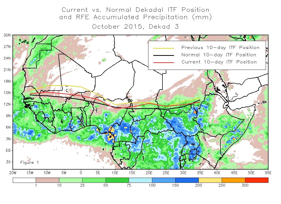
During the period from April 11-20, 2008, the African portion of the Intertropical Front (ITF) was located at around 11.8 degrees north latitude, more than half a degree north of 11.2 north, the normal. The position is significantly further north when compared to the same dekad of 2007 when the ITF was around 10.2 degrees north. Figure 1 shows the current position compared to normal, and the ITF is currently close to normal everywhere but in Sudan where it has had large fluctuations from day to day. From Figures 2 and 3 it is clear that the ITF is near normal in the west, while north of normal in the east. The ITF is currently 12.2 degrees north in the west and 11.9 degrees north in the east Compared with the 1979-2006 mean of around 12.5 degrees north in the west, and a normal position of around 9.7N.
http://www.cpc.ncep.noaa.gov/products/f ... itcz.shtml
Latest Text Summary
During the period from April 11-20, 2008, the African portion of the Intertropical Front (ITF) was located at around 11.8 degrees north latitude, more than half a degree north of 11.2 north, the normal. The position is significantly further north when compared to the same dekad of 2007 when the ITF was around 10.2 degrees north. Figure 1 shows the current position compared to normal, and the ITF is currently close to normal everywhere but in Sudan where it has had large fluctuations from day to day. From Figures 2 and 3 it is clear that the ITF is near normal in the west, while north of normal in the east. The ITF is currently 12.2 degrees north in the west and 11.9 degrees north in the east Compared with the 1979-2006 mean of around 12.5 degrees north in the west, and a normal position of around 9.7N.
http://www.cpc.ncep.noaa.gov/products/f ... itcz.shtml
0 likes
Who is online
Users browsing this forum: No registered users and 272 guests