Non Tropical Atlantic Low

This is the general tropical discussion area. Anyone can take their shot at predicting a storms path.

Moderator: S2k Moderators

Forum rules

The posts in this forum are NOT official forecasts and should not be used as such. They are just the opinion of the poster and may or may not be backed by sound meteorological data. They are NOT endorsed by any professional institution or STORM2K. For official information, please refer to products from the National Hurricane Center and National Weather Service.

Help Support Storm2K
Message
Author
tolakram
Admin
Admin
Posts: 20017
Age: 62
Joined: Sun Aug 27, 2006 8:23 pm
Location: Florence, KY (name is Mark)

Non Tropical Atlantic Low

#1 Postby tolakram » Tue Apr 29, 2008 9:57 am

I think this is spinning down but I've been watching it for a few days and there continues to be light convection near the center.

Image

Every low is a bit different.
0 likes   

User avatar
HURAKAN
Professional-Met
Professional-Met
Posts: 46086
Age: 38
Joined: Thu May 20, 2004 4:34 pm
Location: Key West, FL
Contact:

#2 Postby HURAKAN » Tue Apr 29, 2008 10:04 am

Image

Yesterday I noticed this system but didn't post anything since it's too far north for anything tropical or subtropical to occur. Still, interesting to watch.
0 likes   

User avatar
HURAKAN
Professional-Met
Professional-Met
Posts: 46086
Age: 38
Joined: Thu May 20, 2004 4:34 pm
Location: Key West, FL
Contact:

#3 Postby HURAKAN » Tue Apr 29, 2008 10:08 am

All the images:

Image

Image

Image

Image

Image

Image

Image

GFS 24 hrs:
Image

GFS 48 hrs:
Image

GFS 72 hrs:
Image

GFS 96 hrs:
Image

Windshear:
Image

Windshear tendency:
Image
0 likes   

Frank2
Category 5
Category 5
Posts: 4061
Joined: Mon Jul 25, 2005 12:47 pm

Re: Non Tropical Atlantic Low

#4 Postby Frank2 » Tue Apr 29, 2008 1:36 pm

I couldn't help but notice the strong shear across the Caribbean - looks like the May 5 first (statistical) maximum might pass quietly...
0 likes   

tolakram
Admin
Admin
Posts: 20017
Age: 62
Joined: Sun Aug 27, 2006 8:23 pm
Location: Florence, KY (name is Mark)

Re: Non Tropical Atlantic Low

#5 Postby tolakram » Tue Apr 29, 2008 3:02 pm

So what's powering this sucker anyway. Convection near the center has been persistent all day.


http://www.ssd.noaa.gov/goes/east/natl/loop-rb.html

Image

Image
0 likes   

User avatar
HURAKAN
Professional-Met
Professional-Met
Posts: 46086
Age: 38
Joined: Thu May 20, 2004 4:34 pm
Location: Key West, FL
Contact:

#6 Postby HURAKAN » Tue Apr 29, 2008 3:34 pm

Satellite loops indicate the system is still non-tropical in nature as the low-level circulation looks to be attached to a cold front or trough. Very interesting storm but there shouldn't be any transition to subtropical and/or tropical in the future.
0 likes   

tolakram
Admin
Admin
Posts: 20017
Age: 62
Joined: Sun Aug 27, 2006 8:23 pm
Location: Florence, KY (name is Mark)

Re: Non Tropical Atlantic Low

#7 Postby tolakram » Tue Apr 29, 2008 3:36 pm

Sure, it's too far north and the water is way too cold to boot, but I'm still curious why it's behaving this way. I suppose it can be chalked up to extratropical lows not always following the rule book. :)


SST

Image
0 likes   

tolakram
Admin
Admin
Posts: 20017
Age: 62
Joined: Sun Aug 27, 2006 8:23 pm
Location: Florence, KY (name is Mark)

Re: Non Tropical Atlantic Low

#8 Postby tolakram » Tue Apr 29, 2008 4:35 pm

http://www.ssd.noaa.gov/goes/east/natl/loop-wv.html

Image

The water vapor loop is interesting to look at. You can see the two air masses but it seems to me the center of low pressure is being surrounded by moist air. /shrug If any met wants to school me on what I'm seeing it would be most appreciated. :)
0 likes   

User avatar
HURAKAN
Professional-Met
Professional-Met
Posts: 46086
Age: 38
Joined: Thu May 20, 2004 4:34 pm
Location: Key West, FL
Contact:

#9 Postby HURAKAN » Tue Apr 29, 2008 7:02 pm

TWD 805 PM:

A
DEEP LAYERED TROUGH IS OVER THE REMAINDER OF THE CENTRAL ATLC
WITH THE UPPER LOW CENTERED N OF THE REGION NEAR 35N47W AND A
1000 MB SURFACE LOW NEAR 35N48W. A SURFACE TROUGH EXTENDS INTO
THE REGION THROUGH 32N39W S ALONG 28N41W THEN SW TO 20N54W WITH
ISOLATED SHOWERS WITHIN 90 NM EITHER SIDE OF THE SURFACE TROUGH.
BROAD UPPER RIDGE COVERS THE E ATLC WITH THE AXIS ALONG 24W
EXTENDING TO 31N WITH A DEEP LAYERED LOW/TROUGH INLAND OVER W
AFRICA. A WEAK SURFACE TROUGH IS BENEATH THE UPPER RIDGE
EXTENDING FROM 25N25W TO 31N29W.
0 likes   

Matt-hurricanewatcher

Re: Non Tropical Atlantic Low

#10 Postby Matt-hurricanewatcher » Tue Apr 29, 2008 7:38 pm

It looks kind of subtropical. But appearances can be a challege to put a finger on if it has a warm core. I would say its not impossible that it could develop into a borderline subtropical like system.
0 likes   

tolakram
Admin
Admin
Posts: 20017
Age: 62
Joined: Sun Aug 27, 2006 8:23 pm
Location: Florence, KY (name is Mark)

Re: Non Tropical Atlantic Low

#11 Postby tolakram » Tue Apr 29, 2008 8:14 pm

It's over 64-65F water ... I don't think it can be anything but non-tropical but I would like to know why it's behaving the way it is. All the extratropical lows I remember watching never have convection of any significance near the center of the low. I'm guessing it's an area where the warm/cold or moist/dry air is mixing and creating an area ripe for convection.
0 likes   

MiamiensisWx

Re: Non Tropical Atlantic Low

#12 Postby MiamiensisWx » Tue Apr 29, 2008 8:25 pm

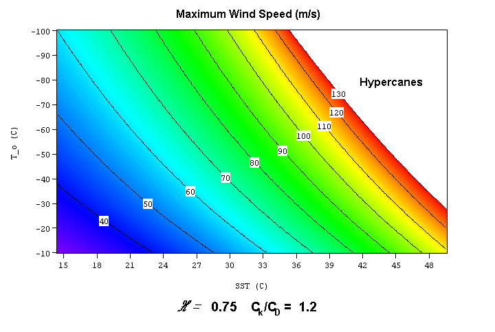
The "water's too cold" argument has been proven false on several occasions. Many tropical and subtropical systems (see Epsilon, Zeta, Ana, et al) have formed over 64-65 F SSTs and even cooler waters. Other factors such as the placement of the upper low above the system, shear, and heat content are far more decisive as to whether the transition and development takes place.

With that said, this one (gale center) likely will not complete the transition to a warm core system at the low levels.
0 likes   

User avatar
george_r_1961
S2K Supporter
S2K Supporter
Posts: 3171
Age: 64
Joined: Sat Oct 12, 2002 9:14 pm
Location: Carbondale, Pennsylvania

#13 Postby george_r_1961 » Tue Apr 29, 2008 10:17 pm

Just glancing at the sattelite imagery it looks like a cold core low that is occluding or closing off and separating from the parent front. It will likely spin down over the next day or so.

If this were late summer or fall I would be concerned that this could become a tropical or subtropical cyclone but like others that have posted in this thread I feel that any tropical development is unlikely.
0 likes   

User avatar
Ptarmigan
Category 5
Category 5
Posts: 5316
Joined: Wed Aug 16, 2006 9:06 pm

Re: Non Tropical Atlantic Low

#14 Postby Ptarmigan » Tue Apr 29, 2008 10:44 pm

MiamiensisWx wrote:The "water's too cold" argument has been proven false on several occasions. Many tropical and subtropical systems (see Epsilon, Zeta, Ana, et al) have formed over 64-65 F SSTs and even cooler waters. Other factors such as the placement of the upper low above the system, shear, and heat content are far more decisive as to whether the transition and development takes place.

With that said, this one (gale center) likely will not complete the transition to a warm core system at the low levels.

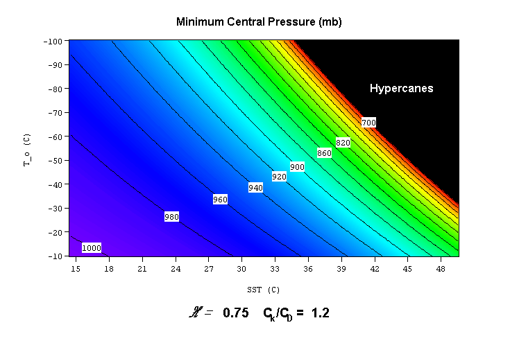
I saw a chart that higher and colder cloud tops is a factor as well.

Image

Image
0 likes   

User avatar
Category 5
Category 5
Category 5
Posts: 10074
Age: 35
Joined: Sun Feb 11, 2007 10:00 pm
Location: New Brunswick, NJ
Contact:

Re: Non Tropical Atlantic Low

#15 Postby Category 5 » Tue Apr 29, 2008 11:36 pm

The title of the thread says it all.

It's a frontal low over 17C waters.
0 likes   

User avatar
Category 5
Category 5
Category 5
Posts: 10074
Age: 35
Joined: Sun Feb 11, 2007 10:00 pm
Location: New Brunswick, NJ
Contact:

Re: Non Tropical Atlantic Low

#16 Postby Category 5 » Tue Apr 29, 2008 11:40 pm

MiamiensisWx wrote:The "water's too cold" argument has been proven false on several occasions. Many tropical and subtropical systems (see Epsilon, Zeta, Ana, et al) have formed over 64-65 F SSTs and even cooler waters. Other factors such as the placement of the upper low above the system, shear, and heat content are far more decisive as to whether the transition and development takes place.

With that said, this one (gale center) likely will not complete the transition to a warm core system at the low levels.


Actually I believe Ana, Epsilon, and Zeta formed over about 22C SST's.
0 likes   

User avatar
HURAKAN
Professional-Met
Professional-Met
Posts: 46086
Age: 38
Joined: Thu May 20, 2004 4:34 pm
Location: Key West, FL
Contact:

#17 Postby HURAKAN » Wed Apr 30, 2008 8:29 am

Image
0 likes   

Cyclone1
Category 5
Category 5
Posts: 2739
Age: 33
Joined: Tue Jun 12, 2007 12:03 pm
Location: Florida

#18 Postby Cyclone1 » Wed Apr 30, 2008 3:16 pm

Cat5: Yeah, I don't think a storm has ever formed over anything colder than 70.
0 likes   


Return to “Talkin' Tropics”

Who is online

Users browsing this forum: Google [Bot] and 25 guests