2008 Severe Weather Thread

U.S. & Caribbean Weather Discussions and Severe Weather Events

Moderator: S2k Moderators

Forum rules

The posts in this forum are NOT official forecast and should not be used as such. They are just the opinion of the poster and may or may not be backed by sound meteorological data. They are NOT endorsed by any professional institution or STORM2K.

Help Support Storm2K
Message
Author
User avatar
Category 5
Category 5
Category 5
Posts: 10074
Age: 35
Joined: Sun Feb 11, 2007 10:00 pm
Location: New Brunswick, NJ
Contact:

Re: 08 Svr Wx thread (Psbl outbreak May 5-8)

#601 Postby Category 5 » Mon May 05, 2008 6:21 pm

*knock knock* NWS Dodge City?

Image
Image
0 likes   

User avatar
Category 5
Category 5
Category 5
Posts: 10074
Age: 35
Joined: Sun Feb 11, 2007 10:00 pm
Location: New Brunswick, NJ
Contact:

Re: 08 Svr Wx thread (Psbl outbreak May 5-8)

#602 Postby Category 5 » Mon May 05, 2008 6:58 pm

Look at these returns!

Image
0 likes   

Ed Mahmoud

Re: 08 Svr Wx thread (Psbl outbreak May 5-8)

#603 Postby Ed Mahmoud » Mon May 05, 2008 7:29 pm

Almost baseball sized hail near Roswell


PRELIMINARY LOCAL STORM REPORT
NATIONAL WEATHER SERVICE ALBUQUERQUE NM
528 PM MDT MON MAY 05 2008

..TIME... ...EVENT... ...CITY LOCATION... ...LAT.LON...
..DATE... ....MAG.... ..COUNTY LOCATION..ST.. ...SOURCE....
..REMARKS..

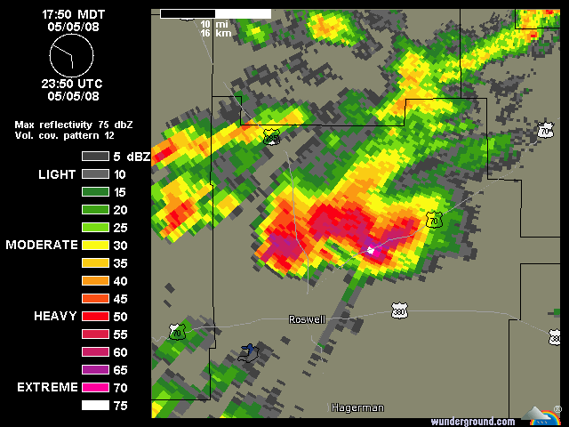
0359 PM HAIL 24 W ROSWELL 33.37N 104.95W
05/05/2008 E2.50 INCH LINCOLN NM STORM CHASER

0409 PM HAIL 17 W ROSWELL 33.37N 104.82W
05/05/2008 E1.00 INCH CHAVES NM AMATEUR RADIO

0514 PM HAIL 5 N ROSWELL 33.44N 104.53W
05/05/2008 E2.75 INCH CHAVES NM AMATEUR RADIO

0517 PM HAIL 10 NW ROSWELL 33.47N 104.65W
05/05/2008 E2.75 INCH CHAVES NM EMERGENCY MNGR
0 likes   

CrazyC83
Professional-Met
Professional-Met
Posts: 34001
Joined: Tue Mar 07, 2006 11:57 pm
Location: Deep South, for the first time!

#604 Postby CrazyC83 » Mon May 05, 2008 8:53 pm

Drove through some REALLY impressive cells near Wilmington, NC today. Stopped for 45 minutes due to extreme rain and hail (up to 1.5 inches).
0 likes   

User avatar
Category 5
Category 5
Category 5
Posts: 10074
Age: 35
Joined: Sun Feb 11, 2007 10:00 pm
Location: New Brunswick, NJ
Contact:

Re: 08 Svr Wx thread (Psbl outbreak May 5-8)

#605 Postby Category 5 » Mon May 05, 2008 9:28 pm

What the heck?

SEVERE THUNDERSTORM WARNING
TXC069-279-060300-
/O.NEW.KLUB.SV.W.0031.080506T0205Z-080506T0300Z/

BULLETIN - EAS ACTIVATION REQUESTED
SEVERE THUNDERSTORM WARNING
NATIONAL WEATHER SERVICE LUBBOCK TX
905 PM CDT MON MAY 5 2008

THE NATIONAL WEATHER SERVICE IN LUBBOCK HAS ISSUED A

* SEVERE THUNDERSTORM WARNING FOR...
SOUTHERN CASTRO COUNTY IN THE PANHANDLE OF TEXAS.
NORTHERN LAMB COUNTY IN NORTHWEST TEXAS.

* UNTIL 1000 PM CDT

* AT 900 PM CDT...NATIONAL WEATHER SERVICE DOPPLER RADAR INDICATED A
SEVERE THUNDERSTORM CAPABLE OF PRODUCING QUARTER SIZE HAIL...AND
DAMAGING WINDS IN EXCESS OF 60 MPH. THIS STORM WAS LOCATED 8 MILES
NORTHWEST OF EARTH
...OR ABOUT 16 MILES NORTHEAST OF MULESHOE...
MOVING EAST AT 20 MPH.

* SOME LOCATIONS NEAR THE PATH OF THIS STORM INCLUDE SUDAN...
AMHERST...OLTON...FIELDTON AND HART.

LARGE HAIL...DAMAGING WINDS...AND VERY HEAVY RAINS ARE EXPECTED WITH
THIS STORM. TAKE COVER IN A SUBSTANTIAL SHELTER.

TO REPORT SEVERE WEATHER...PLEASE CALL THE NATIONAL WEATHER SERVICE
AT 8 0 6 7 4 5 1 2 9 0.

A SEVERE THUNDERSTORM WATCH REMAINS IN EFFECT UNTIL 200 AM CDT
TUESDAY MORNING FOR THE PANHANDLE AND NORTHWEST TEXAS. A SEVERE
THUNDERSTORM WATCH ALSO REMAINS IN EFFECT UNTIL 200 AM CDT TUESDAY
MORNING FOR THE PANHANDLE AND NORTHWEST TEXAS.

LAT...LON 3442 10200 3431 10200 3432 10209 3400 10209
3402 10259 3421 10260 3430 10260 3431 10251
3443 10249
TIME...MOT...LOC 0205Z 285DEG 13KT 3433 10245

$$
0 likes   

User avatar
Cyclenall
Category 5
Category 5
Posts: 6665
Joined: Thu Jun 08, 2006 10:01 pm
Location: Ontario, Canada

Re: 08 Svr Wx thread (Psbl outbreak May 5-8)

#606 Postby Cyclenall » Mon May 05, 2008 9:31 pm

Category 5 wrote:* AT 900 PM CDT...NATIONAL WEATHER SERVICE DOPPLER RADAR INDICATED A
SEVERE THUNDERSTORM CAPABLE OF PRODUCING QUARTER SIZE HAIL...AND
DAMAGING WINDS IN EXCESS OF 60 MPH. THIS STORM WAS LOCATED 8 MILES
NORTHWEST OF EARTH
...OR ABOUT 16 MILES NORTHEAST OF MULESHOE...
MOVING EAST AT 20 MPH.

Wow, that is a classic.
0 likes   

User avatar
KWT
Category 5
Category 5
Posts: 31415
Joined: Tue Aug 17, 2004 11:02 am
Location: UK!!!

#607 Postby KWT » Tue May 06, 2008 11:35 am

Well the UK team chased yesterday, whilst they didnt get a tube they did get a decent wall cloud and the odd funnel develop:

http://uk.youtube.com/watch?v=uytwW91wkMM

Should think there is a fair chance of them getting some actvity today and tomorrow though.
0 likes   

RL3AO
Moderator-Pro Met
Moderator-Pro Met
Posts: 16308
Joined: Thu Jun 14, 2007 10:03 pm
Location: NC

Re: 08 Svr Wx thread (Psbl outbreak May 5-8)

#608 Postby RL3AO » Tue May 06, 2008 12:46 pm

DAY 1 CONVECTIVE OUTLOOK
NWS STORM PREDICTION CENTER NORMAN OK
1109 AM CDT TUE MAY 06 2008

VALID 061630Z - 071200Z

...THERE IS A MDT RISK OF SVR TSTMS THIS AFTERNOON AND EVENING OVER
MUCH OF CENTRAL/EASTERN NEB AND NORTHWEST KS...


...THERE IS A SLGT RISK OF SVR TSTMS ACROSS MUCH OF THE SOUTHERN AND
CENTRAL PLAINS REGION...EXTENDING INTO PARTS OF THE UPPER MS
VALLEY....

MORNING WATER VAPOR IMAGERY SHOWS AN UPPER LOW OVER THE NORTHERN
GULF OF CALIFORNIA...WITH ASSOCIATED SOUTHWESTERLY MID LEVEL JET
BEGINNING TO NOSE OUT OF NORTHERN MEXICO INTO SOUTHERN NM/SOUTHWEST
TX. MEANWHILE...RELATIVELY FAST WEST-NORTHWESTERLY MID LEVEL FLOW
EXTENDS FROM THE NORTHERN ROCKIES INTO THE MID MS VALLEY. CURRENT
INDICATIONS ARE FOR AN ACTIVE SEVERE WEATHER EPISODE THIS AFTERNOON
AND EVENING ACROSS THE CENTRAL AND SOUTHERN PLAINS. THIS ACTIVITY
APPEARS LIKELY TO BE FOCUSED INTO TWO AREAS: NEB/KS AND WEST TX.
UNFORTUNATELY...MODEL GUIDANCE VARIES SIGNIFICANTLY REGARDING
CONVECTIVE EVOLUTION AND TIMING ACROSS THE PLAINS STATES TODAY AND
LESSENS OVERALL CONFIDENCE IN FORECAST SCENARIO.

...NEB/KS...
SATELLITE IMAGERY SHOWS SHORTWAVE TROUGH EMBEDDED IN
WEST-NORTHWESTLY MID LEVEL FLOW OVER EASTERN MT/WESTERN DAKOTAS.
THIS FEATURE WILL TRACK ACROSS THE NORTHERN PLAINS TODAY...PROVIDING
INCREASINGLY STRONG LARGE SCALE FORCING FOR ASCENT. MORNING
SOUNDINGS SHOWED VERY STEEP LAPSE RATES AND THE POTENTIAL FOR LARGE
CAPE VALUES DESPITE RATHER LIMITED LOW LEVEL MOISTURE. A
COMBINATION OF SURFACE DEWPOINTS IN THE MID 50S AND TEMPERATURES IN
THE 70S WILL YIELD MLCAPE VALUES OVER 2000 J/KG AND LITTLE
INHIBITION. CURRENT CONVECTION OVER SOUTHERN SD MAY INTENSIFY THIS
AFTERNOON...WHILE OTHER STORMS FORM SOUTHWESTWARD ACROSS WESTERN
NEB/NORTHWEST KS. ALL OF THESE STORMS WILL TRACK SOUTHEASTWARD
ACROSS THE MDT RISK AREA /MUCH OF NEB AND NORTHWEST KS/ WITH LARGE
HAIL LIKELY...INCLUDING THE POTENTIAL FOR VERY LARGE AND DAMAGING
HAIL. CONVECTION IS LIKELY TO GROW UPSCALE INTO AN ORGANIZED MCS
DURING THE EVENING AND POSE AN ENHANCED THREAT OF DAMAGING WINDS
ACROSS SOUTHEAST NEB INTO EASTERN/CENTRAL KS.

...EASTERN NM/WEST TX...
LATEST SURFACE ANALYSIS SHOWS REMNANT OUTFLOW BOUNDARY FROM
OVERNIGHT CONVECTION EXTENDING FROM NEAR MAF EASTWARD INTO CENTRAL
TX. THIS BOUNDARY IS LIKELY TO WASH OUT AND LIFT NORTHWARD
TODAY...ALLOWING MOIST LOW LEVEL AIR MASS TO ADVECT NORTHWESTWARD
INTO MUCH OF WEST TX AND SOUTHEAST NM. THIS AREA IS UNDER SHORTWAVE
RIDGING THIS MORNING...BUT HEIGHT FALLS WILL COMMENCE BY MID
AFTERNOON WHILE STRONG SURFACE HEATING RESULTS IN MLCAPE VALUES OF
2000-2500 J/KG. AS INFLUENCE OF UPPER LOW BEGINS TO APPROACH THE
DRYLINE LATE THIS AFTERNOON...ISOLATED THUNDERSTORMS ARE LIKELY TO
DEVELOP NEAR THE NM/TX BORDER WEST OF LBB-MAF. THESE STORMS ARE
EXPECTED TO BE SUPERCELLULAR WITH A RISK OF VERY LARGE HAIL AND A
FEW TORNADOES. STORMS WILL BECOME MORE NUMEROUS THROUGH THE EVENING
AND SURGE EASTWARD ACROSS WEST CENTRAL TX OVERNIGHT AS LARGE SCALE
FORCING OVERSPREADS REGION.

..HART/JEWELL.. 05/06/2008
0 likes   

User avatar
Bunkertor
Category 5
Category 5
Posts: 3397
Joined: Tue May 09, 2006 3:48 pm

#609 Postby Bunkertor » Tue May 06, 2008 1:19 pm

All right, i´m back. Peter is married and goes for honeymoon and i´ll stay in germany. :cry:
0 likes   

Ed Mahmoud

Re:

#610 Postby Ed Mahmoud » Tue May 06, 2008 1:37 pm

Bunkertor wrote:All right, i´m back. Peter is married and goes for honeymoon and i´ll stay in germany. :cry:


What is wrong with Germany. All that unpleasant stuff 60 years ago is forgiven, and although my wife will probably never agree, I'd love to visit Munich in Autumn.

Image
0 likes   

Ed Mahmoud

Re:

#611 Postby Ed Mahmoud » Tue May 06, 2008 1:39 pm

KWT wrote:Well the UK team chased yesterday, whilst they didnt get a tube they did get a decent wall cloud and the odd funnel develop:

http://uk.youtube.com/watch?v=uytwW91wkMM

Should think there is a fair chance of them getting some actvity today and tomorrow though.


While greater overall severe odds in Nebraska and Kansas, SPC odds of tornadoes are higher in the Panhandle. Must be a tough decision.


I hope they get more good video.
0 likes   

User avatar
KWT
Category 5
Category 5
Posts: 31415
Joined: Tue Aug 17, 2004 11:02 am
Location: UK!!!

#612 Postby KWT » Tue May 06, 2008 1:44 pm

I think most of the UK teams that are out there are going for the southern option in the Panhandle, problem is there is quite a wide area that could get severe storms today, going to be a case of being able to adjust plans on the hop I suspect.

i suspect tomorrow's possible severe storms are also playing a role in going for the southern option, probably less driving overnight.
0 likes   

Ed Mahmoud

Re: 08 Svr Wx thread: MDT Nebraska and NW KS

#613 Postby Ed Mahmoud » Tue May 06, 2008 2:16 pm

Don't see it on SPC page yet, but AMA AFD update mentioned an 18Z balloon release...
0 likes   

RL3AO
Moderator-Pro Met
Moderator-Pro Met
Posts: 16308
Joined: Thu Jun 14, 2007 10:03 pm
Location: NC

#614 Postby RL3AO » Tue May 06, 2008 2:18 pm

Thats weird. The 18z soundings (3 of them) were there just a couple minutes ago. Now its gone.
0 likes   

User avatar
KWT
Category 5
Category 5
Posts: 31415
Joined: Tue Aug 17, 2004 11:02 am
Location: UK!!!

#615 Postby KWT » Tue May 06, 2008 2:18 pm

I suppose that makes sense but where is AMA by the way, indeed what station is it for that matter i'm not sure?

I guess Amarillo?
0 likes   

Ed Mahmoud

Re:

#616 Postby Ed Mahmoud » Tue May 06, 2008 2:32 pm

KWT wrote:I suppose that makes sense but where is AMA by the way, indeed what station is it for that matter i'm not sure?

I guess Amarillo?


yes.
0 likes   

User avatar
KWT
Category 5
Category 5
Posts: 31415
Joined: Tue Aug 17, 2004 11:02 am
Location: UK!!!

#617 Postby KWT » Tue May 06, 2008 2:35 pm

Cool well will be interesting to see what they show is going on in the atmosphere where they are going up. The team I'm watching are heading towards Childress for some lunch (probns there by now)
0 likes   

User avatar
Bunkertor
Category 5
Category 5
Posts: 3397
Joined: Tue May 09, 2006 3:48 pm

Re: Re:

#618 Postby Bunkertor » Tue May 06, 2008 2:39 pm

Ed Mahmoud wrote:
Bunkertor wrote:All right, i´m back. Peter is married and goes for honeymoon and i´ll stay in germany. :cry:


What is wrong with Germany. All that unpleasant stuff 60 years ago is forgiven, and although my wife will probably never agree, I'd love to visit Munich in Autumn.


No, it´s OK over here, but he´s underway on an isle in the gulf of bengal which i´d prefer, too - for some weeks.

Oktoberfest must be nice but i never was there.
Maybe i should
Image
But this year i can´t either, because my hometown is going to celebrate Grenzegangsfest. This Fest only takes place all 7 years. The highlight is a walking tour along the city limits determined 1239.
Last edited by Bunkertor on Tue May 06, 2008 4:49 pm, edited 1 time in total.
0 likes   

User avatar
KWT
Category 5
Category 5
Posts: 31415
Joined: Tue Aug 17, 2004 11:02 am
Location: UK!!!

#619 Postby KWT » Tue May 06, 2008 3:09 pm

To be honest not sure quite how to respond to that Bunkertor but yeah...

Looks like there is a fair chance something will set up on one of the outflow boundaries eventually or maybe a bulge in the dryline.
0 likes   

User avatar
Bunkertor
Category 5
Category 5
Posts: 3397
Joined: Tue May 09, 2006 3:48 pm

#620 Postby Bunkertor » Tue May 06, 2008 4:36 pm

First TORNADO WARNING for today
NEC017-149-062215-
/O.NEW.KLBF.TO.W.0004.080506T2129Z-080506T2215Z/

BULLETIN - EAS ACTIVATION REQUESTED
TORNADO WARNING
NATIONAL WEATHER SERVICE NORTH PLATTE NE
429 PM CDT TUE MAY 6 2008

THE NATIONAL WEATHER SERVICE IN NORTH PLATTE HAS ISSUED A

* TORNADO WARNING FOR...
SOUTHEASTERN BROWN COUNTY IN NORTH CENTRAL NEBRASKA...
SOUTHERN ROCK COUNTY IN NORTH CENTRAL NEBRASKA...

* UNTIL 515 PM CDT

* AT 426 PM CDT...NATIONAL WEATHER SERVICE DOPPLER RADAR INDICATED A
SEVERE THUNDERSTORM CAPABLE OF PRODUCING A TORNADO 11 MILES
NORTHWEST OF ROSE...OR 21 MILES SOUTHEAST OF AINSWORTH...MOVING
SOUTHEAST AT 31 MPH.

* THE TORNADO WILL BE NEAR...
9 MILES SOUTHWEST OF TWIN LAKES STATE WILDLIFE MANAGEMENT AREA BY
440 PM CDT...
ROSE BY 445 PM CDT...

IN ADDITION TO THE TORNADO...THIS STORM IS CAPABLE OF PRODUCING
QUARTER SIZE HAIL.

A SEVERE THUNDERSTORM WATCH REMAINS IN EFFECT UNTIL 1000 PM CDT
TUESDAY EVENING FOR WESTERN AND NORTH CENTRAL NEBRASKA.
0 likes   


Return to “USA & Caribbean Weather”

Who is online

Users browsing this forum: No registered users and 66 guests