MESOSCALE DISCUSSION 0868
NWS STORM PREDICTION CENTER NORMAN OK
0622 PM CDT SAT MAY 10 2008
AREAS AFFECTED...CNTRL/SRN AR...WRN TN...NRN MS
CONCERNING...TORNADO WATCH 296...298...
VALID 102322Z - 110045Z
THE SEVERE WEATHER THREAT FOR TORNADO WATCH 296...298...CONTINUES.
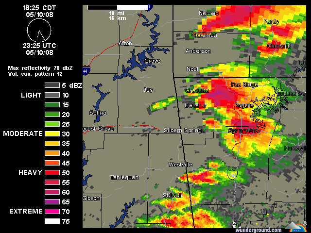
TORNADIC SUPERCELL TSTMS CONTINUE TO INTENSIFY OVER EXTREME SWRN MO
SWD INTO ERN OK EARLY THIS EVENING. TO THE EAST...STRONG-SVR TSTMS
ALSO EXIST...PRIMARILY ALONG SRN EDGE OF A COLD POOL...OR FOOTPRINT
OF EARLIER DAY CONVECTION ACROSS CNTRL AR NEWD INTO THE JONESBORO
AREA.
HIGHEST TORNADO POTENTIAL THROUGH MID-EVENING...WITHIN TORNADO
WATCHES 296/298...WILL LIKELY REMAIN NEAR/S OF FORT SMITH AR EWD
ACROSS CNTRL/SRN AR ALONG THE OUTFLOW BOUNDARY...THEN INTO NWRN/NRN
MS AND WRN TN...INCLUDING THE MEMPHIS METRO AREA.
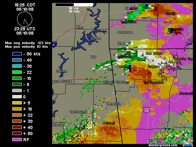
FORT SMITH...MEMPHIS AND LITTLE ROCK VWPS EXHIBITED 0-1KM SRH IN
EXCESS OF 250 M2/S2...AND GIVEN LOW LCLS AND VERY STEEP MID-LEVEL
LAPSE RATES...TORNADIC SUPERCELLS WILL CONTINUE TO BE LIKELY. A
COUPLE OF STRONG TORNADOES WILL REMAIN LIKELY. OTHERWISE...DMGG
WINDS AND VERY LARGE HAIL WILL ALSO BE POSSIBLE.
MEANWHILE...TO THE S ACROSS EXTREME SRN AR INTO GREENVILLE...
GREENWOOD MS AREAS...OR ALONG S OF ROUTE 82...THE SVR WEATHER
THREAT...IF ANY...WILL LIKELY NOT OCCUR UNTIL AFTER DARK.
A COLLABORATION CALL WITH LOCAL WFOS IN AR NWD INTO MO WILL BE
CONDUCTED SOON TO DISCUSS POTENTIAL WATCH REPLACEMENTS AS
NEIGHBORING TORNADO WATCH /WT 293/ TO THE NORTH EXPIRES.
..RACY.. 05/10/2008
ATTN...WFO...MEG...JAN...LZK...SHV...