

Memorial Day Weekend Outbreak 2008
Moderator: S2k Moderators
Forum rules

The posts in this forum are NOT official forecast and should not be used as such. They are just the opinion of the poster and may or may not be backed by sound meteorological data. They are NOT endorsed by any professional institution or STORM2K.
-
Texas Snowman

- Storm2k Moderator

- Posts: 6197
- Joined: Fri Jan 25, 2008 11:29 am
- Location: Denison, Texas
-
CrazyC83
- Professional-Met

- Posts: 34315
- Joined: Tue Mar 07, 2006 11:57 pm
- Location: Deep South, for the first time!
Re: Tornado outbreak again today?
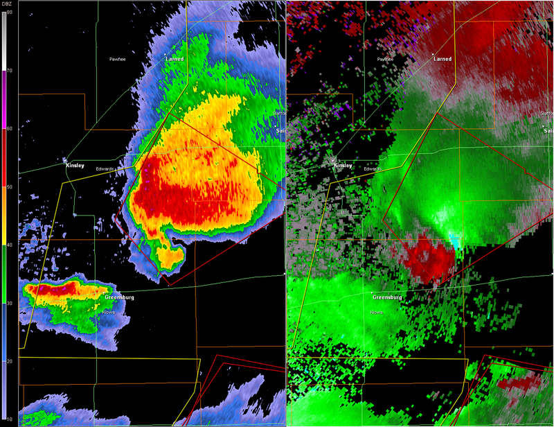
Damage it appears S or E of Greensburg?
SEVERE WEATHER STATEMENT
NATIONAL WEATHER SERVICE DODGE CITY KS
907 PM CDT FRI MAY 23 2008
KSC047-097-145-151-185-240230-
/O.CON.KDDC.TO.W.0040.000000T0000Z-080524T0230Z/
PAWNEE KS-STAFFORD KS-EDWARDS KS-PRATT KS-KIOWA KS-
907 PM CDT FRI MAY 23 2008
...A TORNADO WARNING REMAINS IN EFFECT UNTIL 930 PM CDT FOR
NORTHEASTERN KIOWA...NORTHWESTERN PRATT...EASTERN EDWARDS...
SOUTHWESTERN STAFFORD AND EXTREME SOUTHEASTERN PAWNEE COUNTIES...
AT 903 PM CDT...NATIONAL WEATHER SERVICE DOPPLER RADAR CONTINUED TO
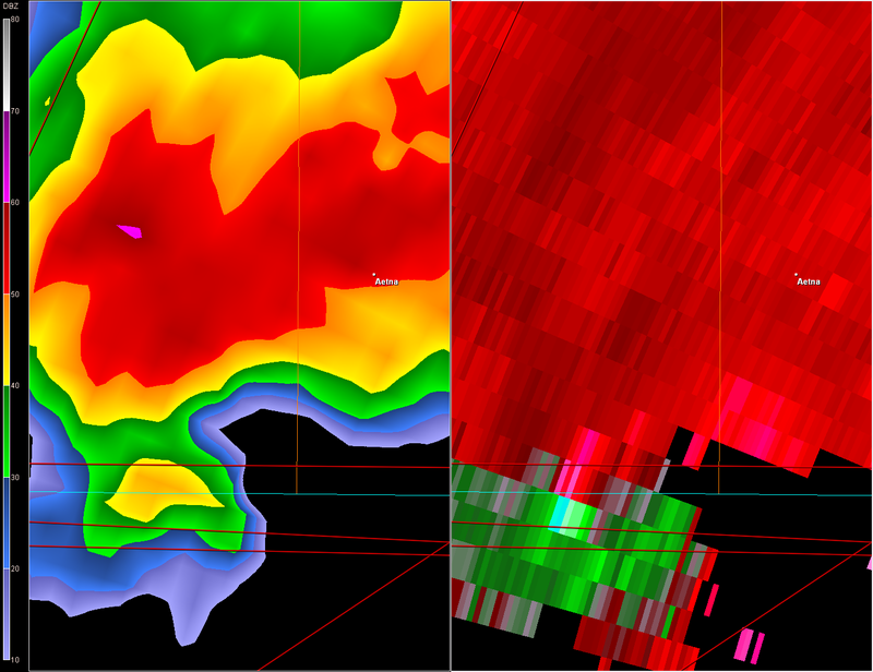
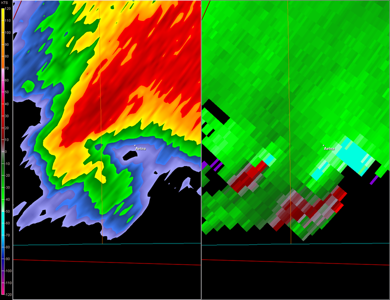
INDICATE A POSSIBLE TORNADO 7 MILES SOUTH OF TROUSDALE...OR 6 MILES
NORTH OF HAVILAND...MOVING NORTHEAST AT 20 MPH.
* LOCATIONS IMPACTED INCLUDE...
FELLSBURG...
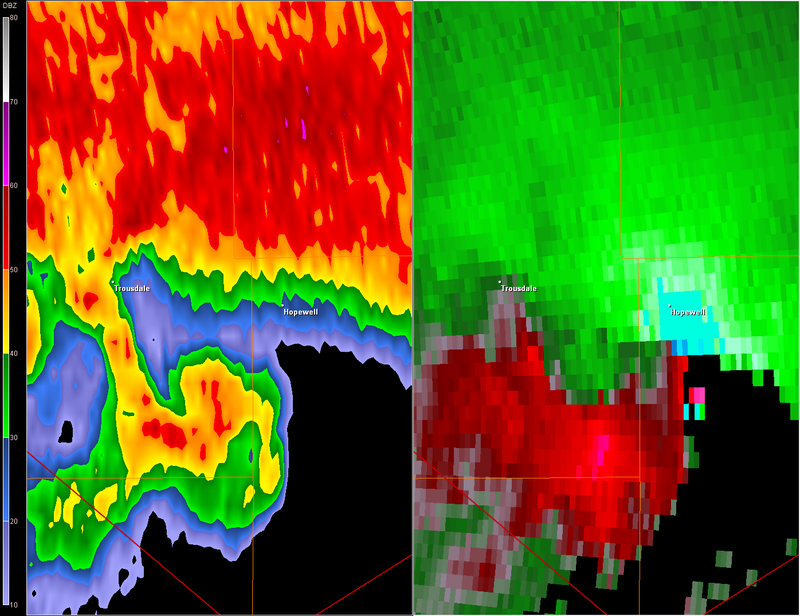
TROUSDALE...
HOPEWELL...
RURAL RESIDENCES OF EASTERN EDWARDS...NORTHEASTERN KIOWA...
NORTHWESTERN PRATT...SOUTHEASTERN PAWNEE AND SOUTHWESTERN STAFFORD
COUNTIES.
THIS STORM HAS A HISTORY OF PRODUCING TORNADOES CAUSING DAMAGE! HAIL
UP TO THE SIZE OF BASEBALLS CAN BE EXPECTED WITH THIS STORM TOO.
THE SAFEST PLACE TO BE DURING A TORNADO IS IN A BASEMENT. IF IN A
MOBILE HOME...EVACUATE TO A SUBSTANTIAL STRUCTURE. GET UNDER A
WORKBENCH OR OTHER PIECE OF STURDY FURNITURE. IF NO BASEMENT IS
AVAILABLE...SEEK SHELTER ON THE LOWEST FLOOR OF THE BUILDING IN AN
INTERIOR HALLWAY OR ROOM SUCH AS A CLOSET. USE BLANKETS OR PILLOWS TO
COVER YOUR BODY AND ALWAYS STAY AWAY FROM WINDOWS.
HEAVY RAINFALL MAY OBSCURE THIS TORNADO. TAKE COVER NOW! IF YOU WAIT
TO SEE OR HEAR IT COMING...IT MAY BE TOO LATE TO GET TO A SAFE PLACE.
TORNADOES AT NIGHT ARE ESPECIALLY DANGEROUS. DO NOT WAIT UNTIL YOU
SEE OR HEAR THE TORNADO...IT MAY BE TOO LATE. TAKE COVER NOW!
A TORNADO WATCH REMAINS IN EFFECT UNTIL 400 AM CDT SATURDAY MORNING
FOR SOUTHWESTERN KANSAS.
LAT...LON 3778 9926 3804 9909 3790 9882 3789 9882
3789 9881 3782 9868 3762 9909
TIME...MOT...LOC 0207Z 229DEG 17KT 3772 9910
$$
BIELINSKI
SEVERE WEATHER STATEMENT
NATIONAL WEATHER SERVICE DODGE CITY KS
907 PM CDT FRI MAY 23 2008
KSC047-097-145-151-185-240230-
/O.CON.KDDC.TO.W.0040.000000T0000Z-080524T0230Z/
PAWNEE KS-STAFFORD KS-EDWARDS KS-PRATT KS-KIOWA KS-
907 PM CDT FRI MAY 23 2008
...A TORNADO WARNING REMAINS IN EFFECT UNTIL 930 PM CDT FOR
NORTHEASTERN KIOWA...NORTHWESTERN PRATT...EASTERN EDWARDS...
SOUTHWESTERN STAFFORD AND EXTREME SOUTHEASTERN PAWNEE COUNTIES...
AT 903 PM CDT...NATIONAL WEATHER SERVICE DOPPLER RADAR CONTINUED TO
INDICATE A POSSIBLE TORNADO 7 MILES SOUTH OF TROUSDALE...OR 6 MILES
NORTH OF HAVILAND...MOVING NORTHEAST AT 20 MPH.
* LOCATIONS IMPACTED INCLUDE...
FELLSBURG...
TROUSDALE...
HOPEWELL...
RURAL RESIDENCES OF EASTERN EDWARDS...NORTHEASTERN KIOWA...
NORTHWESTERN PRATT...SOUTHEASTERN PAWNEE AND SOUTHWESTERN STAFFORD
COUNTIES.
THIS STORM HAS A HISTORY OF PRODUCING TORNADOES CAUSING DAMAGE! HAIL
UP TO THE SIZE OF BASEBALLS CAN BE EXPECTED WITH THIS STORM TOO.
THE SAFEST PLACE TO BE DURING A TORNADO IS IN A BASEMENT. IF IN A
MOBILE HOME...EVACUATE TO A SUBSTANTIAL STRUCTURE. GET UNDER A
WORKBENCH OR OTHER PIECE OF STURDY FURNITURE. IF NO BASEMENT IS
AVAILABLE...SEEK SHELTER ON THE LOWEST FLOOR OF THE BUILDING IN AN
INTERIOR HALLWAY OR ROOM SUCH AS A CLOSET. USE BLANKETS OR PILLOWS TO
COVER YOUR BODY AND ALWAYS STAY AWAY FROM WINDOWS.
HEAVY RAINFALL MAY OBSCURE THIS TORNADO. TAKE COVER NOW! IF YOU WAIT
TO SEE OR HEAR IT COMING...IT MAY BE TOO LATE TO GET TO A SAFE PLACE.
TORNADOES AT NIGHT ARE ESPECIALLY DANGEROUS. DO NOT WAIT UNTIL YOU
SEE OR HEAR THE TORNADO...IT MAY BE TOO LATE. TAKE COVER NOW!
A TORNADO WATCH REMAINS IN EFFECT UNTIL 400 AM CDT SATURDAY MORNING
FOR SOUTHWESTERN KANSAS.
LAT...LON 3778 9926 3804 9909 3790 9882 3789 9882
3789 9881 3782 9868 3762 9909
TIME...MOT...LOC 0207Z 229DEG 17KT 3772 9910
$$
BIELINSKI
0 likes
-
CrazyC83
- Professional-Met
- Posts: 34315
- Joined: Tue Mar 07, 2006 11:57 pm
- Location: Deep South, for the first time!
Re:
Texas Snowman wrote:Hate to even think this way, but Cantore was talking about severe weather zone shifting into Central and Eastern Kansas tomorrow.
If it's even in the ballpark of the last two days, there are more towns and bigger populations in this portion of Kansas I think.
Yep, the eastern third of Kansas has much more people than the central and western parts which are fairly sparsely populated. The threat may also be farther north as well (a la May 5, 2007).
0 likes
-
6SpeedTA95
- Category 5

- Posts: 1206
- Joined: Wed Oct 19, 2005 3:25 pm
- Location: Oklahoma
- Contact:
-
6SpeedTA95
- Category 5
- Posts: 1206
- Joined: Wed Oct 19, 2005 3:25 pm
- Location: Oklahoma
- Contact:
Re: Re:
MiamiensisWx wrote:6SpeedTA95 wrote:Glad that storm is basically over nowhere right now...there's not very many people in its current path.
They're still people.
Ummm did I say they weren't? You ever been to that area of kansas? Its super sparsley populated...
http://maps.google.com/?ie=UTF8&ll=37.7 ... 49817&z=11
Greensburg bottom left corner...I'd much rather have that storm where it is now then heading for a greensburg again, dodge city or even worse wichita/topeka type towns.
0 likes
-
6SpeedTA95
- Category 5
- Posts: 1206
- Joined: Wed Oct 19, 2005 3:25 pm
- Location: Oklahoma
- Contact:
-
MiamiensisWx
Re: Tornado outbreak again today?
I completely agree (and I'm familiar with the area's thin populations), but warnings still exist.
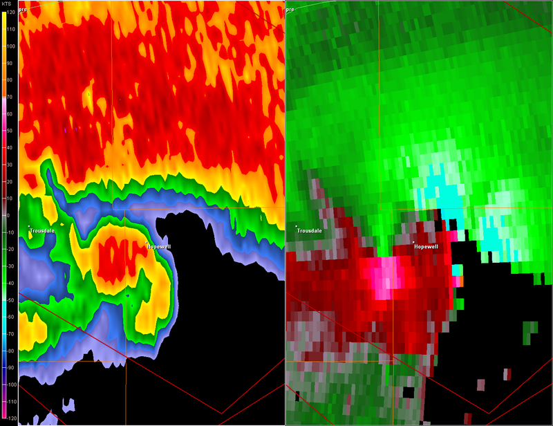
Hopewell, KS is under the gun from former Greensburg cell.
Hopewell, KS is under the gun from former Greensburg cell.
0 likes
-
Texas Snowman
- Storm2k Moderator
- Posts: 6197
- Joined: Fri Jan 25, 2008 11:29 am
- Location: Denison, Texas
Re: Tornado outbreak again today?
Yes, they are still people and yes, glad that these storms are not roaring through Wichita or Topeka.
I remember one time that the late great weatherman Harold Taft at KXAS-TV in Ft. Worth was talking about a tornado that struck rural areas of E. Texas and destroyed a couple of homes.
Anchor said well, good thing that wasn't a severe tornado.
Taft wryly noted "Well, I guess that depends on whether or not one of those houses was yours. If it was, then it was the worst tornado ever."
0 likes
Re: Tornado outbreak again today?
MiamiensisWx wrote:
Hopewell, KS is under the gun from former Greensburg cell.
0 likes

-
Texas Snowman
- Storm2k Moderator
- Posts: 6197
- Joined: Fri Jan 25, 2008 11:29 am
- Location: Denison, Texas
-
6SpeedTA95
- Category 5
- Posts: 1206
- Joined: Wed Oct 19, 2005 3:25 pm
- Location: Oklahoma
- Contact:
Return to “USA & Caribbean Weather”
Who is online
Users browsing this forum: Google [Bot], txtwister78 and 171 guests