Memorial Day Weekend Outbreak 2008
Moderator: S2k Moderators
Forum rules

The posts in this forum are NOT official forecast and should not be used as such. They are just the opinion of the poster and may or may not be backed by sound meteorological data. They are NOT endorsed by any professional institution or STORM2K.
-
6SpeedTA95
- Category 5

- Posts: 1206
- Joined: Wed Oct 19, 2005 3:25 pm
- Location: Oklahoma
- Contact:

-
6SpeedTA95
- Category 5
- Posts: 1206
- Joined: Wed Oct 19, 2005 3:25 pm
- Location: Oklahoma
- Contact:
Re: Re:
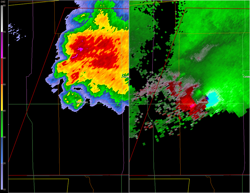
RL3AO wrote:CrazyC83 wrote:Protection: DIRECT HIT by a major tornado
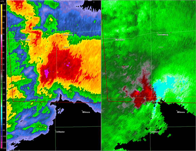
0240 UTC
0244 UTC
ouch
0 likes
-
6SpeedTA95
- Category 5
- Posts: 1206
- Joined: Wed Oct 19, 2005 3:25 pm
- Location: Oklahoma
- Contact:
Re: Re:
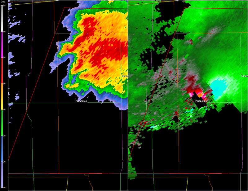
CrazyC83 wrote:6SpeedTA95 wrote:Another tornadic cell is going to go just east of Greensburg
It should remain well south of Greensburg. Sounds like Protection was wiped out though
You would think but look at the last 4 frames...
Its not going ot hit greensburg but will past east of the town.
0 likes
-
6SpeedTA95
- Category 5
- Posts: 1206
- Joined: Wed Oct 19, 2005 3:25 pm
- Location: Oklahoma
- Contact:
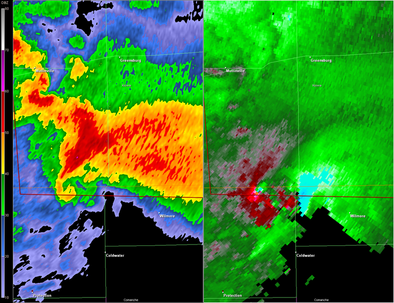
* TORNADO WARNING FOR...
EXTREME NORTHEASTERN COMANCHE COUNTY IN SOUTH CENTRAL KANSAS.
KIOWA COUNTY IN SOUTH CENTRAL KANSAS.
* UNTIL 1045 PM CDT
* AT 958 PM CDT...NATIONAL WEATHER SERVICE DOPPLER RADAR INDICATED A
SEVERE THUNDERSTORM CAPABLE OF PRODUCING A TORNADO 15 MILES SOUTH
OF MULLINVILLE...OR 9 MILES NORTHWEST OF COLDWATER...MOVING
NORTHEAST AT 45 MPH.
* LOCATIONS IMPACTED INCLUDE...
MULLINVILLE...
BELVIDERE...
GREENSBURG...
HAVILAND...
RURAL RESIDENCES OF KIOWA AND NORTHEASTERN COMANCHE COUNTIES.
THIS STORM HAS A HISTORY OF PRODUCING TORNADOES.
WHEN A TORNADO WARNING IS ISSUED BASED ON DOPPLER RADAR...IT MEANS
THAT STRONG ROTATION HAS BEEN DETECTED IN THE STORM. A TORNADO MAY
ALREADY BE ON THE GROUND...OR IS EXPECTED TO DEVELOP SHORTLY. IF YOU
ARE IN THE PATH OF THIS DANGEROUS STORM...MOVE INDOORS AND TO THE
LOWEST LEVEL OF THE BUILDING. STAY AWAY FROM WINDOWS. IF DRIVING...DO
NOT SEEK SHELTER UNDER A HIGHWAY OVERPASS.
THIS WARNING EXTENDS THE PREVIOUS WARNING ISSUED FOR COMANCHE COUNTY.
A TORNADO WATCH REMAINS IN EFFECT UNTIL 400 AM CDT SATURDAY MORNING
FOR SOUTHWESTERN KANSAS.
NWS going as far west as mullenville with this.
0 likes
-
6SpeedTA95
- Category 5
- Posts: 1206
- Joined: Wed Oct 19, 2005 3:25 pm
- Location: Oklahoma
- Contact:
-
CrazyC83
- Professional-Met

- Posts: 34315
- Joined: Tue Mar 07, 2006 11:57 pm
- Location: Deep South, for the first time!
Re:
6SpeedTA95 wrote:* TORNADO WARNING FOR...
EXTREME NORTHEASTERN COMANCHE COUNTY IN SOUTH CENTRAL KANSAS.
KIOWA COUNTY IN SOUTH CENTRAL KANSAS.
* UNTIL 1045 PM CDT
* AT 958 PM CDT...NATIONAL WEATHER SERVICE DOPPLER RADAR INDICATED A
SEVERE THUNDERSTORM CAPABLE OF PRODUCING A TORNADO 15 MILES SOUTH
OF MULLINVILLE...OR 9 MILES NORTHWEST OF COLDWATER...MOVING
NORTHEAST AT 45 MPH.
* LOCATIONS IMPACTED INCLUDE...
MULLINVILLE...
BELVIDERE...
GREENSBURG...
HAVILAND...
RURAL RESIDENCES OF KIOWA AND NORTHEASTERN COMANCHE COUNTIES.
THIS STORM HAS A HISTORY OF PRODUCING TORNADOES.
WHEN A TORNADO WARNING IS ISSUED BASED ON DOPPLER RADAR...IT MEANS
THAT STRONG ROTATION HAS BEEN DETECTED IN THE STORM. A TORNADO MAY
ALREADY BE ON THE GROUND...OR IS EXPECTED TO DEVELOP SHORTLY. IF YOU
ARE IN THE PATH OF THIS DANGEROUS STORM...MOVE INDOORS AND TO THE
LOWEST LEVEL OF THE BUILDING. STAY AWAY FROM WINDOWS. IF DRIVING...DO
NOT SEEK SHELTER UNDER A HIGHWAY OVERPASS.
THIS WARNING EXTENDS THE PREVIOUS WARNING ISSUED FOR COMANCHE COUNTY.
A TORNADO WATCH REMAINS IN EFFECT UNTIL 400 AM CDT SATURDAY MORNING
FOR SOUTHWESTERN KANSAS.
NWS going as far west as mullenville with this.
Don't see why; it is moving northeast. Maybe include Greensburg to be cautious, but that's as far as it needs to include.
0 likes
-
tropicana

- Category 5
- Posts: 8056
- Joined: Sat Sep 27, 2003 6:48 pm
- Location: Niagara Falls, Ontario, Canada
- Contact:
Re: Tornado outbreak again today?
those poor people of Protection KS, i hope they are all safe somehow.
0 likes
-
6SpeedTA95
- Category 5
- Posts: 1206
- Joined: Wed Oct 19, 2005 3:25 pm
- Location: Oklahoma
- Contact:
-
6SpeedTA95
- Category 5
- Posts: 1206
- Joined: Wed Oct 19, 2005 3:25 pm
- Location: Oklahoma
- Contact:
Re:
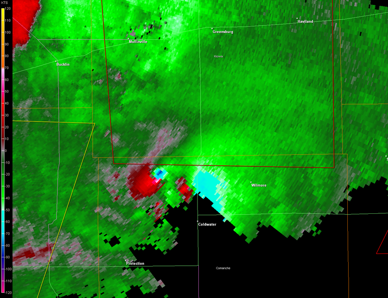
RL3AO wrote:If it continues in the direction it has the past 10 minutes, it would go 1 mile WEST of Greensburg.
It's drifting that far to the north?
0 likes
Re: Re:
6SpeedTA95 wrote:RL3AO wrote:If it continues in the direction it has the past 10 minutes, it would go 1 mile WEST of Greensburg.
It's drifting that far to the north?
Yep. Its moving at 15 degrees right now (NNE)
0 likes
-
6SpeedTA95
- Category 5
- Posts: 1206
- Joined: Wed Oct 19, 2005 3:25 pm
- Location: Oklahoma
- Contact:
Re: Re:
RL3AO wrote:6SpeedTA95 wrote:RL3AO wrote:If it continues in the direction it has the past 10 minutes, it would go 1 mile WEST of Greensburg.
It's drifting that far to the north?
Yep. Its moving at 15 degrees right now (NNE)
ugh
0 likes
Return to “USA & Caribbean Weather”
Who is online
Users browsing this forum: Cpv17, WeatherNewbie and 89 guests