
The National Weather Service in Des Moines has issued a
* Tornado Warning for...
southeastern Clarke County in south central Iowa...
western Lucas County in south central Iowa...
* until 700 PM CDT.
* At 609 PM CDT... National Weather Service Doppler radar indicated a
severe thunderstorm capable of producing a tornado 9 miles
southwest of Woodburn... or 45 miles south of Des Moines... moving
northeast at 24 mph.
* The tornado will be near...
Woodburn by 635 PM CDT...
Lucas by 650 PM CDT...
Chariton Airport by 700 PM CDT...
This is a hazardous situation. Seek shelter in a basement... or in an
interior room. Stay away from windows. If you are outside or in a
car... seek shelter in a reinforced building.
A Tornado Watch remains in effect until 900 PM CDT Sunday evening for
northwestern Iowa.
Memorial Day Weekend Outbreak 2008
Moderator: S2k Moderators
Forum rules

The posts in this forum are NOT official forecast and should not be used as such. They are just the opinion of the poster and may or may not be backed by sound meteorological data. They are NOT endorsed by any professional institution or STORM2K.
Re: Tornado outbreak again today?
Watch that supercell forming in south central IA. Could be quite similar setup to what we're seeing in NE IA right now.
0 likes
-
CrazyC83
- Professional-Met

- Posts: 34315
- Joined: Tue Mar 07, 2006 11:57 pm
- Location: Deep South, for the first time!
SEVERE WEATHER STATEMENT
NATIONAL WEATHER SERVICE QUAD CITIES IA IL
610 PM CDT SUN MAY 25 2008
IAC019-252345-
/O.CON.KDVN.TO.W.0017.000000T0000Z-080525T2345Z/
BUCHANAN IA-
610 PM CDT SUN MAY 25 2008
...A TORNADO WARNING REMAINS IN EFFECT UNTIL 645 PM CDT FOR BUCHANAN
COUNTY...
AT 607 PM CDT...TRAINED SPOTTERS REPORTED A TORNADO ON NORTHEAST SIDE
FAIRBANK WITH BASEBALL SIZE HAIL...MOVING NORTHEAST AT 35 MPH.
A SECOND TORNADO WAS WEST OF FAIRBANK MOVING EAST AT 32 MPH.
THE TORNADO WILL BE NEAR...
HAZLETON AND FONTANA COUNTY PARK AROUND 615 PM CDT...
HAZLETON AROUND 620 PM CDT...
AURORA AROUND 635 PM CDT...
LAMONT AND 9 MILES NORTH OF WINTHROP GOLF COURSE AROUND 640 PM
CDT...
THIS TORNADO IS CAPABLE OF PRODUCING SIGNIFICANT STRUCTURAL DAMAGE TO
BUILDINGS. MOVE TO A SUBSTANTIAL SHELTER NOW!
THIS STORM HAS ALREADY PRODUCED A TORNADO AND REMAINS A THREAT.
THIS STORM IS ALSO CAPABLE OF PRODUCING LARGE HAIL THE SIZE OF
BASEBALLS.
A TORNADO WATCH REMAINS IN EFFECT UNTIL 1000 PM CDT SUNDAY EVENING
FOR EASTERN IOWA AND NORTHEAST MISSOURI.
LAT...LON 4254 9162 4253 9162 4237 9161 4237 9207
4264 9208 4265 9167 4264 9162
TIME...MOT...LOC 2310Z 266DEG 28KT 4261 9199
$$
0 likes
-
CajunMama
- Retired Staff

- Posts: 10791
- Joined: Thu Feb 06, 2003 9:57 pm
- Location: 30.22N, 92.05W Lafayette, LA
Re: Tornado outbreak again today?
Mightybri wrote:Hello-
My name is Brian and I am a storm chaser out of Wichita.
Went running down to Perry today to intercept the very slow moving tornados and caught up with them near the end. It was quite the show except for all the heavy rain and hell that kept occluding the tornados.
We were at a service station under the pylons to escape some of the hell and to get pictures when the Perry Police told us it was either time to head North or go to the basement of the building.
The storm became rainwrapped at that point and we left. For a few scary minutes it was being reported that the tornado had entered Perry but in the end had dissipated.
I'm in the Wichita area so if any of you chase around here, give me a yell.
Brian
Welcome to s2k. Did you get any pictures?
0 likes

-
CajunMama
- Retired Staff
- Posts: 10791
- Joined: Thu Feb 06, 2003 9:57 pm
- Location: 30.22N, 92.05W Lafayette, LA
Re: Tornado outbreak again today?
Melissa wrote:I live near Halstead, Kansas.
It's pretty windy and humid right now.
Hi Melissa...how's your area? I don't know if you got any severe weather or not.
0 likes


000
WFUS53 KDLH 252313
TORDLH
MNC021-061-260000-
/O.NEW.KDLH.TO.W.0004.080525T2311Z-080526T0000Z/
BULLETIN - EAS ACTIVATION REQUESTED
TORNADO WARNING
NATIONAL WEATHER SERVICE DULUTH MN
611 PM CDT SUN MAY 25 2008
THE NATIONAL WEATHER SERVICE IN DULUTH MN HAS ISSUED A
* TORNADO WARNING FOR...
EAST CENTRAL CASS COUNTY IN NORTH CENTRAL MINNESOTA...
SOUTH CENTRAL ITASCA COUNTY IN NORTH CENTRAL MINNESOTA...
* UNTIL 700 PM CDT
* AT 607 PM CDT...NATIONAL WEATHER SERVICE DOPPLER RADAR INDICATED
A SEVERE THUNDERSTORM CAPABLE OF PRODUCING A TORNADO. THE MOST
DANGEROUS PORTION OF THE STORM WAS LOCATED NEAR TOBIQUE... OR 18
MILES EAST OF LEECH LAKE...MOVING EAST AT 25 MPH. WATERSPOUTS HAVE
BEEN REPORTED WITH THIS STORM OVER LEECH LAKE.
* THE MOST DANGEROUS PART OF THIS STORM WILL BE NEAR...
DAYS HIGH LANDING BY 630 PM...
SISEEBAKWET LAKE BY 640 PM...
COHASSET BY 650 PM...
THIS STORM WILL ALSO AFFECT HIGHWAY 6 BETWEEN REMER AND DAYS HIGH
LANDING.
THE SAFEST PLACE TO BE DURING A TORNADO IS IN A BASEMENT. GET UNDER A
WORKBENCH OR OTHER PIECE OF STURDY FURNITURE...OR A BASEMENT
STAIRCASE. IF NO BASEMENT IS AVAILABLE...SEEK SHELTER ON THE LOWEST
FLOOR OF THE BUILDING IN A SMALL INTERIOR ROOM OR HALLWAY. USE
BLANKETS OR PILLOWS TO COVER YOUR BODY.
LAT...LON 4729 9356 4704 9353 4705 9412 4721 9414
TIME...MOT...LOC 2311Z 263DEG 25KT 4712 9398
$$
MILLER
0 likes


-
CrazyC83
- Professional-Met
- Posts: 34315
- Joined: Tue Mar 07, 2006 11:57 pm
- Location: Deep South, for the first time!
Re: Tornado outbreak again today?
SEVERE WEATHER STATEMENT...CORRECTED
NATIONAL WEATHER SERVICE QUAD CITIES IA IL
618 PM CDT SUN MAY 25 2008
IAC019-252345-
/O.CON.KDVN.TO.W.0017.000000T0000Z-080525T2345Z/
BUCHANAN IA-
618 PM CDT SUN MAY 25 2008
...A TORNADO WARNING REMAINS IN EFFECT UNTIL 645 PM CDT FOR BUCHANAN
COUNTY...
AT 616 PM CDT...TRAINED SPOTTERS REPORTED A TORNADO WITH DEBRIS
NEAR HAZLETON. THIS TORNADO WAS MOVING EAST AT 32 MPH.
THE TORNADO WILL BE NEAR...
HAZLETON...NOW!
AURORA AROUND 635 PM CDT...
LAMONT AND 9 MILES NORTH OF WINTHROP GOLF COURSE AROUND 645 PM
CDT...
THIS TORNADO IS CAPABLE OF PRODUCING SIGNIFICANT STRUCTURAL DAMAGE TO
BUILDINGS. MOVE TO A SUBSTANTIAL SHELTER NOW!
THIS STORM IS ALSO CAPABLE OF PRODUCING LARGE HAIL THE SIZE OF
BASEBALLS.
A TORNADO WATCH REMAINS IN EFFECT UNTIL 1000 PM CDT SUNDAY EVENING
FOR EASTERN IOWA AND NORTHEAST MISSOURI.
LAT...LON 4254 9162 4253 9162 4237 9161 4237 9207
4264 9208 4265 9167 4264 9162
TIME...MOT...LOC 2318Z 266DEG 28KT 4262 9193
$$
0 likes
Re: Tornado outbreak again today?
wbug1 wrote:re: above satellite shot
Looks like palm sunday
0 likes
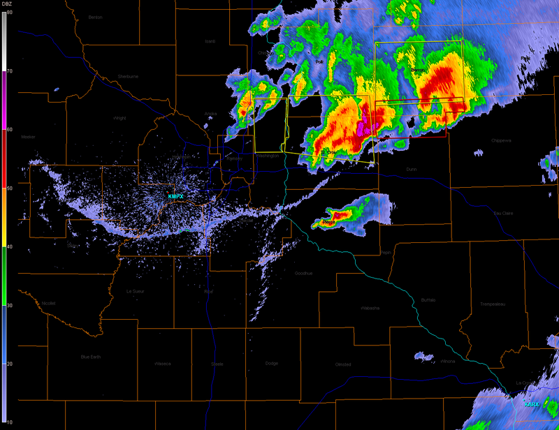
It is outflow there in Minnesota.
SPECIAL WEATHER STATEMENT
NATIONAL WEATHER SERVICE TWIN CITIES/CHANHASSEN MN
559 PM CDT SUN MAY 25 2008
MNZ063-069-070-077-078-WIZ023>025-027-252345-
CHIPPEWA-DAKOTA-DUNN-GOODHUE-PIERCE-RICE-SCOTT-ST. CROIX-WASHINGTON-
559 PM CDT SUN MAY 25 2008
...SIGNIFICANT WEATHER ALERT FOR CHIPPEWA...DAKOTA...SOUTHERN DUNN...
GOODHUE...PIERCE...RICE...SCOTT...SOUTHERN ST. CROIX AND SOUTHERN
WASHINGTON COUNTIES UNTIL 645 PM CDT...
STRONG OUTFLOW WINDS FROM NEARBY THUNDERSTORMS WILL AFFECT AREAS
ALONG A LINE EXTENDING FROM 5 MILES SOUTHWEST OF NEW RICHMOND TO
COTTAGE GROVE TO 5 MILES SOUTHWEST OF LAKEVILLE. WINDS TO AROUND 60
MPH ARE EXPECTED WITH THE OUTFLOW FROM THESE THUNDERSTORMS.
0 likes
-
wbug1
Re: Tornado outbreak again today?
Bunkertor wrote:wbug1 wrote:re: above satellite shot
Looks like palm sunday
I don't know what you mean here.
0 likes
Re: Tornado outbreak again today?
wbug1 wrote:Bunkertor wrote:wbug1 wrote:re: above satellite shot
Looks like palm sunday
I don't know what you mean here.
Looks like the review-satellite-pics of historic events. Was just my first thought.
0 likes
Return to “USA & Caribbean Weather”
Who is online
Users browsing this forum: Cpv17, WeatherNewbie and 80 guests