
Arthur's remnents near the BOC
Moderator: S2k Moderators


-
Aric Dunn
- Category 5

- Posts: 21238
- Age: 43
- Joined: Sun Sep 19, 2004 9:58 pm
- Location: Ready for the Chase.
- Contact:
Re: INVEST 90L=Special Tropical Disturbance Statement
cycloneye wrote::uarrow: There is a models thread
hmmmmmm..........ok
0 likes

Re: INVEST 90L=Special Tropical Disturbance Statement
Dvorak estimates:
30/2345 UTC 16.8N 87.8W TOO WEAK 90L
30/2345 UTC 16.8N 87.8W TOO WEAK 90L
0 likes


Re: INVEST 90L=Special Tropical Disturbance Statement
CycloneNL wrote:Nrl says now :
30kts and 1005mb
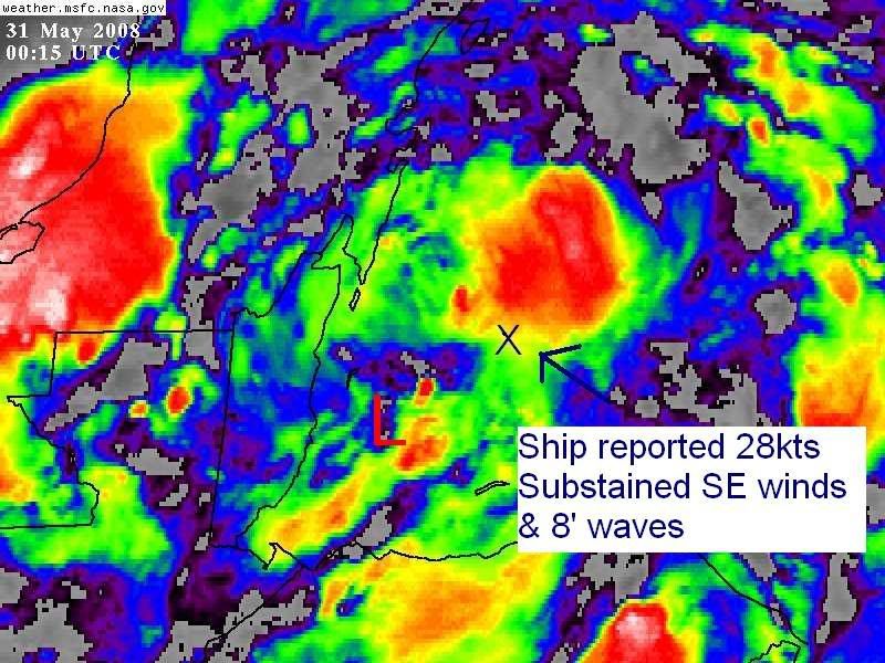
A ship just NE from LLC at 00z reported SE winds substained at 28knots from the SE with 8' waves, clearly not from outflow boundary because convection is to the north of the ship at that time and reported a temperature of 80 deg.
ID T1 TIME LAT LON DIST HDG WDIR WSPD GST WVHT DPD APD MWD PRES PTDY ATMP WTMP DEWP VIS TCC TIDE S1HT S1PD S1DIR S2HT S2PD S2DIR Ice Sea SwH SwP SwD WWH WWP WWD STEEPNESS
(GMT) nm °T °T kts kts ft sec sec °T in in °F °F °F mi 8th ft ft sec °T ft sec °T Acc Ice ft sec ft sec °T
------------------------------------------------------------------------------------------------------------------------------------------------------------------------------------------------------------------------------------------------------------
SHIP S 0000 17.80 -86.30 115 20 130 28.0 - 8.2 1.0 - - 29.71 +0.12 80.6 80.6 - 6.2 8 - 8.2 1.0 130 8.2 1.0 130 ---- ----- - - - - - - -
1 observations reported for 0000 GMT
0 likes

Re: INVEST 90L=Special Tropical Disturbance Statement
Thunder44 wrote:Dvorak estimates:
30/2345 UTC 16.8N 87.8W TOO WEAK 90L
SAB says too weak, but TAFB says T1.0.
AL, 90, 200805302345, 10, DVTS, CI, , 1690N, 8760W, , 2, 25, 2, , , , , , , , , , , , , , , , , , TAFB, JC, I, 3, 1010 /////, , , GOES12, CSC, T, DT = 1.0 BASED ON 0.2 BANDING. NLINEMET= 1.0 PAT=
0 likes
-
MiamiensisWx


SHIPS 00z run:
Code: Select all
                    *   ATLANTIC SHIPS INTENSITY FORECAST       *
                    *        GOES/OHC INPUT INCLUDED            *
                    *      INVEST  AL902008  05/31/08  00 UTC   *

TIME (HR)          0     6    12    18    24    36    48    60    72    84    96   108   120
V (KT) NO LAND    30    35    39    43    49    56    64    72    76    78    79    76    76
V (KT) LAND       30    35    30    28    28    27    27    27    27    27    27    28    28
V (KT) LGE mod    30    32    31    29    28    27    27    27    27    27    27    31    35

SHEAR (KTS)        9    14    15    11     7    14     3     4     8     9    14    14    13
SHEAR DIR        337   342   358   357   315   326    28   356    91    87    79   112    92
SST (C)         28.4  28.7  28.8  29.0  29.1  29.5  29.6  29.5  29.4  29.4  29.4  29.5  29.5
POT. INT. (KT)   140   146   147   150   151   158   161   159   157   157   157   159   159
ADJ. POT. INT.   129   135   136   138   139   145   150   149   148   148   148   151   151
200 MB T (C)   -53.3 -53.7 -53.8 -53.2 -52.9 -53.6 -52.6 -53.3 -52.4 -53.0 -52.2 -52.9 -52.4
TH_E DEV (C)       8     7     6     9     9     7    10     8    10     8    10     9    11
700-500 MB RH     81    78    74    72    73    71    69    66    69    68    67    58    56
GFS VTEX (KT)     12    13    13    13    15    14    14    14    13    12    11     9     9
850 MB ENV VOR    64    62    61    71    74    77    95    98   114   103    98    70    84
200 MB DIV        81    56    51    59    73    50    56    23    47    30    41    46    34
LAND (KM)         75     5   -63  -127  -148   -78   -88   -96  -102   -98   -47    44   140
LAT (DEG N)     16.9  17.2  17.5  17.7  17.9  17.9  17.8  17.4  17.0  16.7  16.6  16.3  16.0
LONG(DEG W)     87.5  88.2  88.8  89.4  90.0  91.1  92.3  93.8  95.3  96.8  98.3  99.7 101.2
STM SPEED (KT)     5     7     6     6     6     5     7     7     7     7     7     7     7
HEAT CONTENT      58     0  9999  9999  9999  9999  9999  9999  9999  9999  9999     0  9999

  FORECAST TRACK FROM BAMM      INITIAL HEADING/SPEED (DEG/KT):270/  3      CX,CY:  -2/  0
  T-12 MAX WIND:  25            PRESSURE OF STEERING LEVEL (MB):  509  (MEAN=625)
  GOES IR BRIGHTNESS TEMP. STD DEV. 100-300 KM RAD:  16.5 (MEAN=20.0)
  % GOES IR PIXELS WITH T < -20 C    50-200 KM RAD:  92.0 (MEAN=68.6)

                        INDIVIDUAL CONTRIBUTIONS TO INTENSITY CHANGE
                         6   12   18   24   36   48   60   72   84   96  108  120
                        ----------------------------------------------------------
  SAMPLE MEAN CHANGE     1.   2.   3.   4.   6.   8.   9.  10.  11.  12.  12.  13.
  SST POTENTIAL          0.   1.   1.   2.   6.  11.  17.  22.  26.  30.  32.  34.
  VERTICAL SHEAR         1.   2.   3.   4.   5.   7.   8.   9.   9.   8.   7.   7.
  PERSISTENCE            1.   2.   2.   3.   3.   3.   2.   2.   2.   1.   1.   0.
  200/250 MB TEMP.       0.   0.   0.   0.   0.  -1.  -1.  -1.  -1.  -1.  -1.  -1.
  THETA_E EXCESS         0.  -1.  -1.  -1.  -2.  -2.  -3.  -3.  -4.  -5.  -5.  -5.
  700-500 MB RH          0.   0.   0.   0.   0.   0.   0.   0.   0.  -1.  -2.  -3.
  GFS VORTEX TENDENCY    0.   0.   0.   1.   1.   1.   1.   0.  -2.  -2.  -4.  -4.
  850 MB ENV VORTICITY   0.   1.   1.   1.   2.   3.   4.   5.   5.   6.   6.   6.
  200 MB DIVERGENCE      0.   1.   1.   2.   3.   4.   4.   5.   5.   5.   5.   5.
  ZONAL STORM MOTION     0.   0.   0.   0.   0.   0.  -1.  -1.  -1.  -2.  -2.  -2.
  STEERING LEVEL PRES    0.   1.   1.   1.   1.   2.   2.   3.   3.   2.   2.   2.
  DAYS FROM CLIM. PEAK   0.   0.   0.  -1.  -1.  -2.  -2.  -2.  -3.  -3.  -3.  -4.
                        ----------------------------------------------------------
  SUB-TOTAL CHANGE       4.   7.  11.  16.  23.  33.  41.  48.  52.  52.  49.  48.

  SATELLITE ADJUSTMENTS ----------------------------------------------------------
  MEAN ADJUSTMENT        0.   0.   0.   0.  -1.  -1.  -1.  -1.  -1.  -1.  -1.  -2.
  GOES IR STD DEV        1.   2.   2.   2.   2.   2.   1.   0.  -1.  -1.  -1.   0.
  GOES IR PIXEL COUNT    0.   1.   1.   1.   1.   1.   0.   0.  -1.  -1.  -1.   0.
  OCEAN HEAT CONTENT     0.   0.   0.   0.   0.   0.  -1.  -1.  -1.  -1.  -1.  -1.
                        ----------------------------------------------------------
  TOTAL ADJUSTMENT       1.   2.   3.   3.   2.   2.   0.  -2.  -3.  -3.  -3.  -3.
                        ----------------------------------------------------------
  TOTAL CHANGE (KT)      5.   9.  13.  19.  26.  34.  42.  46.  48.  49.  46.  46.

   ** 2008 ATLANTIC RI INDEX AL902008     INVEST 05/31/08  00 UTC **
           ( 25 KT OR MORE MAX WIND INCREASE IN NEXT 24 HR)

 12 HR PERSISTENCE (KT):   5.0 Range:-45.0 to  30.0 Scaled/Wgted Val:  0.7/  1.2
 850-200 MB SHEAR (KT) :  11.2 Range: 35.1 to   3.2 Scaled/Wgted Val:  0.8/  1.2
 D200 (10**7s-1)       :  64.0 Range:-20.0 to 149.0 Scaled/Wgted Val:  0.5/  0.7
 POT = MPI-VMAX (KT)   : 105.5 Range: 25.1 to 130.7 Scaled/Wgted Val:  0.8/  0.9
 850-700 MB REL HUM (%):  83.0 Range: 56.0 to  88.0 Scaled/Wgted Val:  0.8/  0.3
 % area w/pixels <-30 C:  85.0 Range: 17.0 to 100.0 Scaled/Wgted Val:  0.8/  0.2
 STD DEV OF IR BR TEMP :  12.5 Range: 35.1 to   3.2 Scaled/Wgted Val:  0.7/  0.9
 Heat content (KJ/cm2) :  29.0 Range:  0.0 to 132.0 Scaled/Wgted Val:  0.2/  0.0

 Prob of RI for 25 kt RI threshold=    44% is   3.6 times the sample mean(12.3%)
 Prob of RI for 30 kt RI threshold=    30% is   3.9 times the sample mean( 7.8%)
 Prob of RI for 35 kt RI threshold=    14% is   3.0 times the sample mean( 4.5%)
0 likes
-
DESTRUCTION5

- Category 5
- Posts: 4430
- Age: 44
- Joined: Wed Sep 03, 2003 11:25 am
- Location: Stuart, FL
-
Derek Ortt

-
DESTRUCTION5
- Category 5
- Posts: 4430
- Age: 44
- Joined: Wed Sep 03, 2003 11:25 am
- Location: Stuart, FL
Melbourne Discussion:
TUE-THU...(PREV DISC)
EAST COAST TROUGH WILL GRADUALLY FILL/LIFT OUT AND BY THU A DEEP
LAYER RIDGE IS FORECAST OVER THE WESTERN ATLANTIC...WITH A DEEPENING
LAYER OF SOUTHEAST/SOUTH FLOW. BY LATE WEEK PROSPECTS FOR INCREASING
MOISTURE LOOK BETTER. UNTIL THEN...EXPECT A SMALL CHANCE FOR
AFTERNOON SHOWERS/STORMS...PROBABLY ON TUE SIMILAR TO THE PREVIOUS
FEW DAYS...THEN SHIFTING MORE TOWARDS THE WEST COAST ON WED.
AN UPSTREAM SHORTWAVE TROUGH IS SHOWN MOVING ACROSS THE SOUTHERN
PLAINS THU AND WE WILL HAVE TO SEE IF THIS FEATURE IS FAR ENOUGH
SOUTH TO BEGIN LIFTING QUASI STATIONARY TROPICAL LOW OVER CENTRAL
AMERICA. THESE EARLY SEASON SYSTEMS CAN MEANDER OVER THE TROPICAL
LATITUDES FOR LONG PERIODS OF TIME BEFORE SUBTROPICAL RIDGING
BREAKS DOWN ENOUGH TO INDUCE A NORTHWARD MOTION.
&&
.AVIATION...
0 likes
-
Ad Novoxium
- Category 1

- Posts: 348
- Age: 35
- Joined: Sat May 03, 2008 2:12 am
Re: Re:
Ad Novoxium wrote:RL3AO wrote:Quit ripping on the LBAR. It got it right once last year.
Which was that?
TD10.
It was the only model that had it dart NW into the panhandle of Florida. The rest had it going towards New Orleans.
0 likes

Re: INVEST 90L=Special Tropical Disturbance Statement
Convection on the increase tonight - overall organization improving with colder cloud tops. With NRL's estimated movement of west at 3 mph and the center about 50 miles offshore it'll stay offshore for at least 12 hours - SHIPs ramps it up to 39 kts at 12 hrs so we could conceivably have a weak tropical storm or depression prior to landfall in the Yucatan. The latest 18Z GFS essentially meanders this low toward the BOC, stalls it, moves it east, stalls it, and then slowly lifts it north into the GOM in 5-6 days. Might be an interesting week of cloud watching. My question is: does this become Arthur or is it Alma if it regenerates into a tropical storm?
0 likes
-
senorpepr

- Military Met/Moderator

- Posts: 12542
- Age: 43
- Joined: Fri Aug 22, 2003 9:22 pm
- Location: Mackenbach, Germany
- Contact:
Re: INVEST 90L=Special Tropical Disturbance Statement
ronjon wrote:My question is: does this become Arthur or is it Alma if it regenerates into a tropical storm?
Arthur.
0 likes
Who is online
Users browsing this forum: No registered users and 13 guests