Development in Northwest Caribbean?

This is the general tropical discussion area. Anyone can take their shot at predicting a storms path.

Moderator: S2k Moderators

Forum rules

The posts in this forum are NOT official forecasts and should not be used as such. They are just the opinion of the poster and may or may not be backed by sound meteorological data. They are NOT endorsed by any professional institution or STORM2K. For official information, please refer to products from the National Hurricane Center and National Weather Service.

Help Support Storm2K
Message
Author
User avatar
Innotech
Category 5
Category 5
Posts: 1031
Joined: Mon Aug 30, 2004 5:32 pm
Location: Lafayette, Louisiana
Contact:

Re: Development in Northwest Caribbean?

#41 Postby Innotech » Mon Jun 02, 2008 12:04 am

CYCLONE MIKE wrote:Shrimper, his family could be chartering a smaller boat that only takes 5 or 6 people. A lot of guides in this region run about $400-$500 per group based on 4 or more people. That equals to $100 for his share. We have tons of charter services that will take you out fishing for that amount of money here.

bingo.
Its a small charter. I didnt set it up, it has already been reserved. We rented an 18 person camp for the week.
0 likes   

User avatar
drezee
S2K Supporter
S2K Supporter
Posts: 3664
Joined: Mon Jun 09, 2003 12:49 pm
Location: FL

Re: Development in Northwest Caribbean?

#42 Postby drezee » Mon Jun 02, 2008 1:39 am

TS force winds gust at Belize, likely Thunderstrom related...

9:00 PM 78.8 °F / 26.0 °C 77.0 °F / 25.0 °C 94% 29.80 in / 1009 hPa 1.9 miles / 3.0 kilometers ESE 23.0 mph / 37.0 km/h / 10.3 m/s 39.1 mph / 63.0 km/h / 17.5 m/s N/A Rain , Thunderstorm Thunderstorms
0 likes   

User avatar
Meso
Category 5
Category 5
Posts: 1609
Age: 38
Joined: Mon Aug 09, 2004 12:14 pm
Location: South Africa
Contact:

#43 Postby Meso » Mon Jun 02, 2008 2:06 am

Fresh out the oven, 00z EURO
Image

Small low South of Cuba,nothing significant...At 240 hours there is still nothing major,a bump in the ridge with some 15ms winds which is probably a tropical wave

Image

00z CMC long range,168 hours.. A low in the gulf
0 likes   

User avatar
drezee
S2K Supporter
S2K Supporter
Posts: 3664
Joined: Mon Jun 09, 2003 12:49 pm
Location: FL

Re: Development in Northwest Caribbean?

#44 Postby drezee » Mon Jun 02, 2008 2:28 am

A fun place to be right right would be on a hilltop in central Belize. I could only imagine the rainfall rates. 6 inches an hour...
0 likes   

User avatar
HURAKAN
Professional-Met
Professional-Met
Posts: 46086
Age: 38
Joined: Thu May 20, 2004 4:34 pm
Location: Key West, FL
Contact:

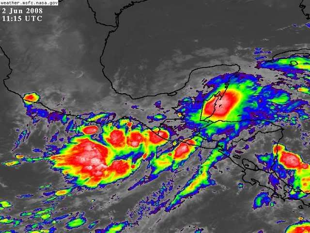
#45 Postby HURAKAN » Mon Jun 02, 2008 6:36 am

Image

Very unstable.
0 likes   

User avatar
Chacor
Category 5
Category 5
Posts: 10229
Joined: Mon Oct 02, 2006 10:43 pm
Location: Singapore

#46 Postby Chacor » Mon Jun 02, 2008 7:13 am

Back on the TWO now.

ABNT20 KNHC 021144
TWOAT
TROPICAL WEATHER OUTLOOK
NWS TPC/NATIONAL HURRICANE CENTER MIAMI FL
800 AM EDT MON JUN 2 2008

FOR THE NORTH ATLANTIC...CARIBBEAN SEA AND THE GULF OF MEXICO...

THE REMNANTS OF ARTHUR CONTINUE TO PRODUCE HEAVY RAINS OVER PORTIONS
OF BELIZE...GUATEMALA...AND SOUTHEASTERN MEXICO. WHILE
REDEVELOPMENT OF THIS SYSTEM IS NOT EXPECTED...ASSOCIATED HEAVY
RAINS COULD CAUSE LIFE-THREATENING FLASH FLOODS AND MUD SLIDES...
ESPECIALLY IN MOUNTAINOUS TERRAIN...DURING THE NEXT COUPLE OF DAYS
AS IT MOVES SLOWLY WESTWARD.

ELSEWHERE...TROPICAL CYCLONE FORMATION IS NOT EXPECTED DURING THE
NEXT 48 HOURS.

$$
FORECASTER RHOME
0 likes   

User avatar
gatorcane
S2K Supporter
S2K Supporter
Posts: 23691
Age: 47
Joined: Sun Mar 13, 2005 3:54 pm
Location: Boca Raton, FL

Re: Development in Northwest Caribbean?

#47 Postby gatorcane » Mon Jun 02, 2008 7:15 am

NHC has now indicated that the NW Caribbean is a watch area. It has shaded this area as an area of potential development. The entire area looks to be stationary or drifting NE. I'll be closely watching this area over the next couple of days.

See Atlantic overview map
http://www.nhc.noaa.gov/
0 likes   

User avatar
Chacor
Category 5
Category 5
Posts: 10229
Joined: Mon Oct 02, 2006 10:43 pm
Location: Singapore

#48 Postby Chacor » Mon Jun 02, 2008 7:18 am

Well, gatorcane, if we're being technical then it's not quite a watch area, with less than 20% chance of TC formation within 48 hours. It's basically the graphical TWO, just on a fancy map. The TWO itself says redevelopment is not anticipated.

(Edited: 48 hours not 24)
Last edited by Chacor on Mon Jun 02, 2008 7:34 am, edited 1 time in total.
0 likes   

User avatar
HURAKAN
Professional-Met
Professional-Met
Posts: 46086
Age: 38
Joined: Thu May 20, 2004 4:34 pm
Location: Key West, FL
Contact:

#49 Postby HURAKAN » Mon Jun 02, 2008 7:19 am

Chacor, no one is expecting Arthur to redevelop, but with the current trough still present, there is always a possibility of a new LLC developing near the Yucatan peninsula.
0 likes   

User avatar
gatorcane
S2K Supporter
S2K Supporter
Posts: 23691
Age: 47
Joined: Sun Mar 13, 2005 3:54 pm
Location: Boca Raton, FL

Re:

#50 Postby gatorcane » Mon Jun 02, 2008 7:21 am

Chacor wrote:Well, gatorcane, if we're being technical then it's not quite a watch area, with less than 20% chance of TC formation within 24 hours. It's basically the graphical TWO, just on a fancy map. The TWO itself says redevelopment is not anticipated.


Indeed but the chances are higher than usual in that area. Looks like the trough to the north is influencing the NE drift. Finally there is some kind of weakness to pull it out of the Yucatan it appears. It does have an escape path to the NE. The NW GOM is still dominated by a ridge at the moment though.

http://www.ssd.noaa.gov/goes/east/watl/loop-wv.html
0 likes   

User avatar
HURAKAN
Professional-Met
Professional-Met
Posts: 46086
Age: 38
Joined: Thu May 20, 2004 4:34 pm
Location: Key West, FL
Contact:

#51 Postby HURAKAN » Mon Jun 02, 2008 7:30 am

Image
0 likes   

RL3AO
Moderator-Pro Met
Moderator-Pro Met
Posts: 16308
Joined: Thu Jun 14, 2007 10:03 pm
Location: NC

#52 Postby RL3AO » Mon Jun 02, 2008 7:55 am

Is that a front in the GOM? Will it be able to pull the area north?

Image
0 likes   

Ed Mahmoud

Re: Development in Northwest Caribbean?

#53 Postby Ed Mahmoud » Mon Jun 02, 2008 8:16 am

I think that is the tail end of a front, although here in SE Texas there is no evidence of frontal passage, with Southerly winds and forecast highs in the mid 90sF (mid 30sC)
0 likes   

cpdaman
Category 5
Category 5
Posts: 3131
Joined: Sat Jun 10, 2006 11:44 am
Location: SPB county (gulf stream)

Re: Development in Northwest Caribbean?

#54 Postby cpdaman » Mon Jun 02, 2008 8:19 am

appears to be a mid/upper level trough sweeping down from the NW (clipping florida)

as well as increasing chance for Pm Storms throughout the state
0 likes   

User avatar
gatorcane
S2K Supporter
S2K Supporter
Posts: 23691
Age: 47
Joined: Sun Mar 13, 2005 3:54 pm
Location: Boca Raton, FL

#55 Postby gatorcane » Mon Jun 02, 2008 8:22 am

That is a shortwave that is is currently pushing SE through Florida. Yes it is eroding the ridge in the NE GOM.
0 likes   

Frank2
Category 5
Category 5
Posts: 4061
Joined: Mon Jul 25, 2005 12:47 pm

Re: Development in Northwest Caribbean?

#56 Postby Frank2 » Mon Jun 02, 2008 9:13 am

Still (and as you alluded to earlier), anything that could possibly form would likely scoot NE in response to the trough currently moving off the southeast US coast, per usual for this time of year...

http://www.goes.noaa.gov/browsh.html
0 likes   

User avatar
gatorcane
S2K Supporter
S2K Supporter
Posts: 23691
Age: 47
Joined: Sun Mar 13, 2005 3:54 pm
Location: Boca Raton, FL

#57 Postby gatorcane » Mon Jun 02, 2008 10:47 am

While the NW Caribbean is active this morning, I think the area we are all going to be focusing on is 91E. GFS is already wanting to bring 91E into the BOC in 36 hours and with a trough eroding the ridge currently protecting the GOM, we could see something enter the GOM later this week.
0 likes   

User avatar
KWT
Category 5
Category 5
Posts: 31415
Joined: Tue Aug 17, 2004 11:02 am
Location: UK!!!

#58 Postby KWT » Mon Jun 02, 2008 10:58 am

Yep that could wel lbe the case gatorcane, IF it does develop then we could well see that system cross over. Meanwhile this area still needs to be watched and don't be surprised if at some time in the next 3 days or so this is decalred an invest because it does look interesting and the convection has constantly been bursting now for over 36hrs in that exact same spot, once it starts to head away from the Yucatan we really need to watch in case a circulation develops.

If nothing occurs at least it should hopefully give some rainfall to the places that need it eventually.
0 likes   

User avatar
wxman57
Moderator-Pro Met
Moderator-Pro Met
Posts: 22978
Age: 67
Joined: Sat Jun 21, 2003 8:06 pm
Location: Houston, TX (southwest)

Re:

#59 Postby wxman57 » Mon Jun 02, 2008 12:10 pm

HURAKAN wrote:Chacor, no one is expecting Arthur to redevelop, but with the current trough still present, there is always a possibility of a new LLC developing near the Yucatan peninsula.


But the NHC discussion for that 20% area mentions only Arthur's remnants, not any other possible development.
0 likes   

User avatar
srainhoutx
S2K Supporter
S2K Supporter
Posts: 6919
Age: 67
Joined: Sun Jan 14, 2007 11:34 am
Location: Haywood County, NC
Contact:

Re: Development in Northwest Caribbean?

#60 Postby srainhoutx » Mon Jun 02, 2008 12:13 pm

Snipet from EP TWD...

WEAK CUT OFF CYCLONIC VORTEX OVER BAY OF CAMPECHE PRODUCING
DIFFLUENT FLOW IN COMBINATION WITH CENTRAL MEXICO RIDGE
ENHANCING DEEP CONVECTION OVER REMNANTS OF ARTHUR AND OVER GULF
OF TEHUANTEPEC...WHERE DEVELOPMENT OF LOW PRES CENTER IS
EXPECTED WITHIN NEXT 36-48 HRS. AREA CONTINUES UNDER HEAVY
PRECIPITATION.


http://www.nhc.noaa.gov/text/refresh/MI ... 1610.shtml?
0 likes   


Return to “Talkin' Tropics”

Who is online

Users browsing this forum: Bobbyh83, jgh, southmdwatcher, USTropics and 40 guests