Arthur's remnents near the BOC
Moderator: S2k Moderators
-
MGC

- S2K Supporter

- Posts: 5940
- Joined: Sun Mar 23, 2003 9:05 pm
- Location: Pass Christian MS, or what is left.
Re: Arthur dissipates over Mexico/Guatemala border
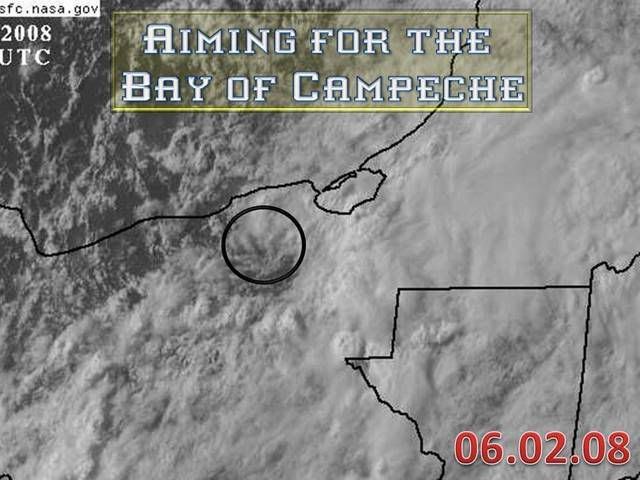
Arthur's remnant low does look to be making a mad dash for the BOC. If it does I bet it refires as 91E moves inland soon....MGC
0 likes

Re: Arthur dissipates over Mexico/Guatemala border
There is a lot of dry air near Arthurs remnant circulation. Could see a naked swirl get back out over the BOC but I doubt it gets upgraded.
0 likes


Re: Arthur dissipates over Mexico/Guatemala border
Nimbus wrote:There is a lot of dry air near Arthurs remnant circulation. Could see a naked swirl get back out over the BOC but I doubt it gets upgraded.
I agree. There's also some stronger northerly shear now in the BOC, that's not from 91E.
0 likes


-
StormspinnerD2

Vis. imagery loops show there certainly is a circulation stormspinnerD2:
http://www.ssd.noaa.gov/goes/flt/t1/sloop-vis.html
http://www.ssd.noaa.gov/goes/flt/t1/sloop-vis.html
0 likes
-
Stratosphere747
- Category 5

- Posts: 3772
- Joined: Thu Sep 11, 2003 8:34 pm
- Location: Surfside Beach/Freeport Tx
- Contact:
Re:
HURAKAN wrote:
Arthur is still there and closer to the BOC than ever.
Only problem is that isn't Arthur.
0 likes
-
srainhoutx

- S2K Supporter
- Posts: 6919
- Age: 68
- Joined: Sun Jan 14, 2007 11:34 am
- Location: Haywood County, NC
- Contact:
Re: Re:
Stratosphere747 wrote:HURAKAN wrote:
Arthur is still there and closer to the BOC than ever.
Only problem is that isn't Arthur.
Bingo. Final advisory issued yesterday.
0 likes
-
HURAKAN

- Professional-Met

- Posts: 46084
- Age: 39
- Joined: Thu May 20, 2004 4:34 pm
- Location: Key West, FL
- Contact:
Re: Re:
Stratosphere747 wrote:HURAKAN wrote:
Arthur is still there and closer to the BOC than ever.
Only problem is that isn't Arthur.
They used to call it Arthur, I still call it Arthur. It hasn't dissipated (the LLC).
0 likes


Re: Arthur dissipates over Mexico/Guatemala border
Nimbus wrote:There is a lot of dry air near Arthurs remnant circulation. Could see a naked swirl get back out over the BOC but I doubt it gets upgraded.
Agreed, the amount of dry air is quite impressive, but it's moving out quickly--as you can see from a 14 hour Water Vapor loop, pay close attention to the BOC. The humid air is moving in quickly from the east. By tomorrow night, it might even be approaching Gulf of Honduras moisture levels. Shear is dropping in the area too--as can be seen by increasing amounts of convection nearer the center of the spinning blob. If so, and if this little blob can make it into the Bay, we could start to see development in the Bay of Campeche, something which has been predicted by every global model for the last two or three weeks. The situation might be about to get interesting. Also interesting to note weather conditions in Ciudad del Carmen and Villahermosa. They indicate an East wind at CdC and a NNW wind at Villahermosa. Both are reporting 1006 mb. I would estimate that the center of the low is about halfway between the cities and about 30 miles from the coast.
0 likes
-
Stratosphere747
- Category 5
- Posts: 3772
- Joined: Thu Sep 11, 2003 8:34 pm
- Location: Surfside Beach/Freeport Tx
- Contact:
Re: Re:
HURAKAN wrote:Stratosphere747 wrote:HURAKAN wrote:
Arthur is still there and closer to the BOC than ever.
Only problem is that isn't Arthur.
They used to call it Arthur, I still call it Arthur. It hasn't dissipated (the LLC).
"Remnants of" and we can call it even...
0 likes
-
Matt-hurricanewatcher
Re: Arthur dissipates over Mexico/Guatemala border
The LLC has reformed at 18.6 north/91.9 west and is moving west-northwestward. It appears to be well defined and some of the obs make it appear that it maybe near the surface and closed. I expect Bret or Jose 2005 like system out of this. As for the other system over the Eastern Pacific it looks very good and should be a depression by 5am.
0 likes

Re: Arthur dissipates over Mexico/Guatemala border
drezee 12:02pm wrote:Arthur is dead....but whatever of a center it has left has turned NW and is at 18.1 and 91.8.
Last official position was LOCATED NEAR 17.4N 91.3W AT 02/0300Z
I guess I was onto something...I will say it since I have no shame...uhhhhmm (clearing my throat)...
LADIES AND GENTLEMEN WE HAVE A REMERGING TROPICAL SYSTEM ON OUR HANDS!!!!
0 likes
-
HURAKAN
- Professional-Met
- Posts: 46084
- Age: 39
- Joined: Thu May 20, 2004 4:34 pm
- Location: Key West, FL
- Contact:

TROPICAL WEATHER OUTLOOK
NWS TPC/NATIONAL HURRICANE CENTER MIAMI FL
800 PM EDT MON JUN 2 2008
FOR THE NORTH ATLANTIC...CARIBBEAN SEA AND THE GULF OF MEXICO...
1. THE REMNANTS OF ARTHUR CONTINUE TO PRODUCE WIDESPREAD CLOUDINESS AND
LOCALIZED HEAVY RAINS OVER PORTIONS OF BELIZE...GUATEMALA...AND
SOUTHEASTERN MEXICO. REDEVELOPMENT OF THIS SYSTEM IS NOT
EXPECTED DURING THE NEXT COUPLE OF DAYS AS IT MOVES SLOWLY
WESTWARD...BUT ASSOCIATED HEAVY RAINS COULD CAUSE LIFE-THREATENING
FLASH FLOODS AND MUD SLIDES...ESPECIALLY IN MOUNTAINOUS
TERRAIN.
ELSEWHERE...TROPICAL CYCLONE FORMATION IS NOT EXPECTED DURING THE
NEXT 48 HOURS.
$$
FORECASTER KNABB/BLAKE
0 likes

Re: Arthur dissipates over Mexico/Guatemala border
IT'S ALIVE Upper air environment is getting better but it has a long way to go to be favorable. just a few shear base T-storms near the center. I don't know if it will have enough low pressure left to kick off anything on it's own. Should be something to watch for the next couple of days.
0 likes
Who is online
Users browsing this forum: No registered users and 86 guests