Central Atlantic / Eastern Atlantic
Moderator: S2k Moderators
Forum rules

The posts in this forum are NOT official forecasts and should not be used as such. They are just the opinion of the poster and may or may not be backed by sound meteorological data. They are NOT endorsed by any professional institution or STORM2K. For official information, please refer to products from the National Hurricane Center and National Weather Service.
-
bvigal

- S2K Supporter

- Posts: 2276
- Joined: Sun Jul 24, 2005 8:49 am
- Location: British Virgin Islands
- Contact:
Re: Central Atlantic / Coast of Africa
Been seeing this on the gfs model for a couple of days, not as a low, just an area of moisture about 10N 35w that moves NW. Until today the model recurved it before 50W, but latest takes it just beyond 20N 60W and poof. Wonder if 0z model is going to look significantly different?
0 likes
-
Aric Dunn
- Category 5

- Posts: 21238
- Age: 43
- Joined: Sun Sep 19, 2004 9:58 pm
- Location: Ready for the Chase.
- Contact:
here is a nearby bouy ... no pressure .. but winds are NNE
http://www.ndbc.noaa.gov/station_page.php?station=41026
it should pass just south of this bouy tonight....
http://www.ndbc.noaa.gov/station_page.php?station=41026
it should pass just south of this bouy tonight....
0 likes
-
Aric Dunn
- Category 5
- Posts: 21238
- Age: 43
- Joined: Sun Sep 19, 2004 9:58 pm
- Location: Ready for the Chase.
- Contact:
Re:
KWT wrote:So its pretty clear that the odds are amazingly heavily stacked against a system such as this, this far east forming, all we have from the looks of things is TD2 and TS Ana.
again climatology is just a history class ... it does not affect the real world weather just tells us what has happened.. presently the system is not doing so bad given the environment its been in .. but that seems to be changing..
0 likes
-
Gustywind

- Category 5
- Posts: 12334
- Joined: Mon Sep 03, 2007 7:29 am
- Location: Baie-Mahault, GUADELOUPE
Re: Central Atlantic / Coast of Africa
simeon9benjamin wrote:These waves are looking good for this time in the season. With water temperatures well above normal in that region and the african dust being less of a factor. This could make for an interesting set up for July as these waves travel west into the caribbean.
Absolutely good post
0 likes
-
Gustywind
- Category 5
- Posts: 12334
- Joined: Mon Sep 03, 2007 7:29 am
- Location: Baie-Mahault, GUADELOUPE
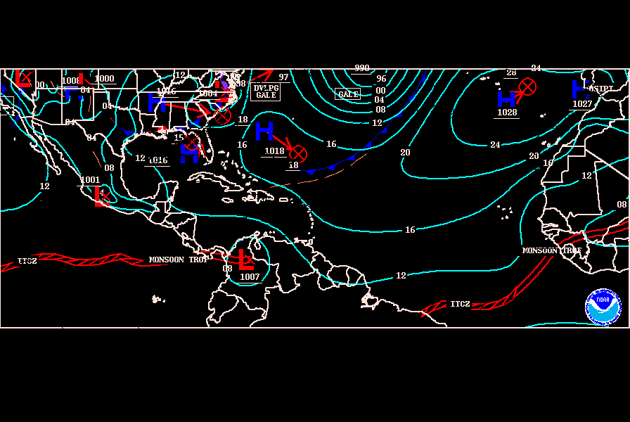
000
AXNT20 KNHC 032320
TWDAT
TROPICAL WEATHER DISCUSSION
NWS TPC/NATIONAL HURRICANE CENTER MIAMI FL
805 PM EDT TUE JUN 03 2008
TROPICAL WEATHER DISCUSSION FOR NORTH AMERICA...CENTRAL
AMERICA...GULF OF MEXICO...CARIBBEAN SEA...NORTHERN SECTIONS OF
SOUTH AMERICA...AND ATLANTIC OCEAN TO THE AFRICAN COAST FROM THE
EQUATOR TO 32N. THE FOLLOWING INFORMATION IS BASED ON SATELLITE
IMAGERY...METEOROLOGICAL ANALYSIS...WEATHER OBSERVATIONS...AND
RADAR.
BASED ON 1800 UTC SURFACE ANALYSIS AND SATELLITE IMAGERY THROUGH
2315 UTC.
...TROPICAL WAVES...
A TROPICAL WAVE REMAINS WELL DEFINED ALONG 36W S OF 17N MOVING W
10-15 KT. A WEAK CIRCULATION IS EMBEDDED ALONG THE AXIS NEAR 9N.
THIS WAVE IS VERY LARGE WITH ITS ASSOCIATED CYCLONIC LOW LEVEL
CLOUD FIELD BETWEEN 30W-40W. SCATTERED MODERATE CONVECTION IS
WITHIN 30NM RADIUS OF 10N36W. MORE CONVECTION IS ALONG THE ITCZ.
TROPICAL WAVE IS APPROACHING THE LESSER ANTILLES ALONG 61W S OF
16N MOVING W 10-15 KT. THIS WAVE STILL EXHIBITS A WEAK INVERTED
V-SHAPE IN ITS LOW LEVEL CLOUD FIELD. 24 HOUR PRESSURE
DIFFERENCES OVER THE LESSER ANTILLES ARE 1 MB LOWER THAN THIS
TIME YESTERDAY. SCATTERED MODERATE CONVECTION IS NEAR BARBADOS
FROM 13N-14N BETWEEN 59W-61W. SIMILAR CONVECTION IS ALSO INLAND
OVER NE VENEZUELA FROM 6N-10N BETWEEN 61W-66W.
Humm interresting trend each waves are increasing things are getting pretty tasty


AXNT20 KNHC 032320
TWDAT
TROPICAL WEATHER DISCUSSION
NWS TPC/NATIONAL HURRICANE CENTER MIAMI FL
805 PM EDT TUE JUN 03 2008
TROPICAL WEATHER DISCUSSION FOR NORTH AMERICA...CENTRAL
AMERICA...GULF OF MEXICO...CARIBBEAN SEA...NORTHERN SECTIONS OF
SOUTH AMERICA...AND ATLANTIC OCEAN TO THE AFRICAN COAST FROM THE
EQUATOR TO 32N. THE FOLLOWING INFORMATION IS BASED ON SATELLITE
IMAGERY...METEOROLOGICAL ANALYSIS...WEATHER OBSERVATIONS...AND
RADAR.
BASED ON 1800 UTC SURFACE ANALYSIS AND SATELLITE IMAGERY THROUGH
2315 UTC.
...TROPICAL WAVES...
A TROPICAL WAVE REMAINS WELL DEFINED ALONG 36W S OF 17N MOVING W
10-15 KT. A WEAK CIRCULATION IS EMBEDDED ALONG THE AXIS NEAR 9N.
THIS WAVE IS VERY LARGE WITH ITS ASSOCIATED CYCLONIC LOW LEVEL
CLOUD FIELD BETWEEN 30W-40W. SCATTERED MODERATE CONVECTION IS
WITHIN 30NM RADIUS OF 10N36W. MORE CONVECTION IS ALONG THE ITCZ.
TROPICAL WAVE IS APPROACHING THE LESSER ANTILLES ALONG 61W S OF
16N MOVING W 10-15 KT. THIS WAVE STILL EXHIBITS A WEAK INVERTED
V-SHAPE IN ITS LOW LEVEL CLOUD FIELD. 24 HOUR PRESSURE
DIFFERENCES OVER THE LESSER ANTILLES ARE 1 MB LOWER THAN THIS
TIME YESTERDAY. SCATTERED MODERATE CONVECTION IS NEAR BARBADOS
FROM 13N-14N BETWEEN 59W-61W. SIMILAR CONVECTION IS ALSO INLAND
OVER NE VENEZUELA FROM 6N-10N BETWEEN 61W-66W.
Humm interresting trend each waves are increasing
0 likes
-
Gustywind
- Category 5
- Posts: 12334
- Joined: Mon Sep 03, 2007 7:29 am
- Location: Baie-Mahault, GUADELOUPE
We shoud experience a slight deterioration with the twave at 61W approaching the east carib tonight as the week before, maybe some water after the dry and hot day.
http://www.meteo.fr/temps/domtom/antill ... Tagant.jpg
From NATIONAL WEATHER SERVICE SAN JUAN PR
AWCA82 TJSJ 032013
RWSVI
WEATHER SUMMARY FOR THE U.S. VIRGIN ISLANDS
NATIONAL WEATHER SERVICE SAN JUAN PR
413 PM AST TUE JUN 3 2008
SKIES VARIED FROM PARTLY CLOUDY TO MOSTLY CLOUDY ACROSS THE U.S.
VIRGIN ISLANDS DURING THE AFTERNOON. SCATTERED SHOWERS WERE
DETECTED BY DOPPLER RADAR MAINLY TO THE NORTH OF SAINT THOMAS AND
OVER WATER BETWEEN EASTERN PUERTO RICO AND THE VIRGIN ISLANDS.
EAST TO SOUTHEAST WIND PREVAILED AT 15 TO 20 MPH WITH HIGH
TEMPERATURES IN THE MID 80S.
WEATHER CONDITIONS THIS EVENING WILL REMAIN SOMEWHAT CLOUDY UNTIL
SOME PATCHES OF MID TO HIGH LEVEL CLOUDS MOVE FURTHER EAST.
SCATTERED SHOWERS AND ISOLATED THUNDERSTORMS WILL PERSIST OVER
THE COASTAL WATERS AND AT TIMES THEY COULD MOVE INLAND ACROSS THE
TERRITORY. A TROPICAL WAVE WAS APPROACHING THE LESSER ANTILLES
THIS AFTERNOON AND IS EXPECTED TO ENTER THE EASTERN CARIBBEAN
WATERS TONIGHT AND BEGIN IMPACTING THE WEATHER ACROSS THE U.S.
VIRGIN ISLANDS MAINLY ON WEDNESDAY.
MARINE CONDITIONS WILL DETERIORATE AS THE TROPICAL WAVE ENTERS THE
NORTHEASTERN CARIBBEAN WATERS LATE TONIGHT AND WEDNESDAY. THIS WILL
INCREASE THE POTENTIAL FOR THUNDERSTORMS...GUSTY WINDS AND LOCALLY
HEAVY RAINFALL ACROSS PARTS OF THE REGIONAL WATERS. SMALL CRAFT
SHOULD EXERCISE CAUTION...ESPECIALLY NEAR THUNDERSTORMS DUE TO GUSTY
WINDS AND DANGEROUS CLOUD TO WATER LIGHTNING.
$$
0 likes
-
bvigal
- S2K Supporter
- Posts: 2276
- Joined: Sun Jul 24, 2005 8:49 am
- Location: British Virgin Islands
- Contact:
Re: Central Atlantic / Coast of Africa
(Hey Gusty!)
I was running the CenAtl AVN loop just a bit ago, to look at this wave, and thought, 'look at that, is that dust?' on the infrared sat. So I pulled up the SAL analysis and the TPW pics, just for grins, and then pasted them into a jpg, which I'm posting here for anyone else who might like the comparison (all sat snaps are at 0z). Anyway, I'm still not convinced this little spin has a future.

I was running the CenAtl AVN loop just a bit ago, to look at this wave, and thought, 'look at that, is that dust?' on the infrared sat. So I pulled up the SAL analysis and the TPW pics, just for grins, and then pasted them into a jpg, which I'm posting here for anyone else who might like the comparison (all sat snaps are at 0z). Anyway, I'm still not convinced this little spin has a future.
0 likes
-
Gustywind
- Category 5
- Posts: 12334
- Joined: Mon Sep 03, 2007 7:29 am
- Location: Baie-Mahault, GUADELOUPE
Re: Central Atlantic / Coast of Africa
bvigal wrote:(Hey Gusty!)
I was running the CenAtl AVN loop just a bit ago, to look at this wave, and thought, 'look at that, is that dust?' on the infrared sat. So I pulled up the SAL analysis and the TPW pics, just for grins, and then pasted them into a jpg, which I'm posting here for anyone else who might like the comparison (all sat snaps are at 0z). Anyway, I'm still not convinced this little spin has a future.
Ok hi Bvigal glad to meet you here, yeah yeah it seems for that's dust
0 likes
-
Aric Dunn
- Category 5
- Posts: 21238
- Age: 43
- Joined: Sun Sep 19, 2004 9:58 pm
- Location: Ready for the Chase.
- Contact:
Re: Central Atlantic / Coast of Africa
Gustywind wrote:bvigal wrote:(Hey Gusty!)
I was running the CenAtl AVN loop just a bit ago, to look at this wave, and thought, 'look at that, is that dust?' on the infrared sat. So I pulled up the SAL analysis and the TPW pics, just for grins, and then pasted them into a jpg, which I'm posting here for anyone else who might like the comparison (all sat snaps are at 0z). Anyway, I'm still not convinced this little spin has a future.
Ok hi Bvigal glad to meet you here, yeah yeah it seems for that's dusthttp://www.ssd.noaa.gov/goes/east/carb/wv-l.jpg maybe a complicated trip with this patch of dust, but the dust will not sweep it after the 45w ( moist air on sat pic)... whereas we could see a another decent wave.. thus without any low pressure and very deep convection, that's pretty usual for this time of the year... The wave at 60w should bring showers close to tstorms given our weather forecasters in better environnement ( less dry).
yeah ... the dry air and small amount of dust is keeping it in check but moisture is on the increase.
http://www.ssd.noaa.gov/goes/east/catl/loop-avn.html
check out the convection being pulled in from east and se
0 likes
-
knotimpaired

- Category 1

- Posts: 495
- Joined: Fri May 20, 2005 4:14 am
- Location: Vieques, PR
- Contact:
Hi everyone,
You only hear from us during this time of the year because of our location and not because we do not care about the weather up north, but we opted the move south to forget about the winters.
While this season is starting out to have the waves coming through I just wanted to let you know that we down here in the Caribbean, while appreciating your interest, pay 100% interest in one poster.
When Cycloneye posts something, we perk up and listen.
He is our eyes and ears down here. God bless Luis.
0 likes
-
Gustywind
- Category 5
- Posts: 12334
- Joined: Mon Sep 03, 2007 7:29 am
- Location: Baie-Mahault, GUADELOUPE
Re:
knotimpaired wrote:Hi everyone,
You only hear from us during this time of the year because of our location and not because we do not care about the weather up north, but we opted the move south to forget about the winters.
While this season is starting out to have the waves coming through I just wanted to let you know that we down here in the Caribbean, while appreciating your interest, pay 100% interest in one poster.
When Cycloneye posts something, we perk up and listen.
He is our eyes and ears down here. God bless Luis.
Hi my friend from the north, yeah Luis is pretty impressive with his analysis and maybe... a Cyloneye lol

0 likes
-
Gustywind
- Category 5
- Posts: 12334
- Joined: Mon Sep 03, 2007 7:29 am
- Location: Baie-Mahault, GUADELOUPE
000
AXNT20 KNHC 040550
TWDAT
TROPICAL WEATHER DISCUSSION
NWS TPC/NATIONAL HURRICANE CENTER MIAMI FL
205 AM EDT WED JUN 04 2008
TROPICAL WEATHER DISCUSSION FOR NORTH AMERICA...CENTRAL
AMERICA...GULF OF MEXICO...CARIBBEAN SEA...NORTHERN SECTIONS OF
SOUTH AMERICA...AND ATLANTIC OCEAN TO THE AFRICAN COAST FROM THE
EQUATOR TO 32N. THE FOLLOWING INFORMATION IS BASED ON SATELLITE
IMAGERY...METEOROLOGICAL ANALYSIS...WEATHER OBSERVATIONS...AND
RADAR.
BASED ON 0000 UTC SURFACE ANALYSIS AND SATELLITE IMAGERY THROUGH
0515 UTC.
...TROPICAL WAVES...
A TROPICAL WAVE REMAINS WELL DEFINED ALONG 36W/37W S OF 17N
MOVING W 10-15 KT. A WEAK CIRCULATION IS EMBEDDED ALONG THE AXIS
NEAR 9N. THIS WAVE IS VERY LARGE WITH ITS ASSOCIATED CYCLONIC
LOW LEVEL CLOUD FIELD BETWEEN 31W-41W. SCATTERED MODERATE
CONVECTION IS WITHIN 90 NM ON EITHER SIDE OF THE AXIS BETWEEN
10N-12N. Trying to organize? a low pressure is added with 1012 mb near 10N 37w on the map... as Aric Dunn was saying in his last post
  http://www.nhc.noaa.gov/tafb_latest/ATSA_latest.gif
TROPICAL WAVE IS ACROSS THE LESSER ANTILLES ALONG 62W S OF 17N
MOVING W 10-15 KT. 24 HOUR PRESSURE DIFFERENCES OVER THE LESSER
ANTILLES ARE 1 MB LOWER THAN THIS TIME YESTERDAY. SCATTERED
MODERATE CONVECTION IS INLAND OVER E VENEZUELA FROM 5N-10N
BETWEEN 61W-66W. This brings some scattered showers.
000
AWCA82 TJSJ 040857
RWSVI
WEATHER SUMMARY FOR THE U.S. VIRGIN ISLANDS
NATIONAL WEATHER SERVICE SAN JUAN PR
457 AM AST WED JUN 4 2008
VARIABLY CLOUDY SKIES PREVAILED ACROSS THE U.S. VIRGIN ISLANDS
OVERNIGHT. THE NWS DOPPLER WEATHER RADAR INDICATED A FEW SCATTERED
SHOWERS ACROSS THE SURROUNDING COASTAL WATERS. THE WINDS HAVE
BEEN GENERALLY OUT OF THE EAST SOUTHEAST AT 12 MPH OR LESS AND THE
LOCAL TEMPERATURES RANGED FROM THE UPPER 70S TO THE LOW 80S.
AS THE MORNING PROGRESSES...SCATTERED SHOWERS AND ISOLATED
THUNDERSTORMS WILL CONTINUE OVER THE COASTAL WATERS MOVING INLAND
FROM TIME TO TIME ACROSS THE LOCAL ISLANDS.
A TROPICAL WAVE CURRENTLY LOCATED ACROSS THE SOUTHEAST CARIBBEAN
IS MOVING WEST NORTHWEST INTO THE LOCAL AREA. THE NORTHERN
PORTIONS OF THIS WAVE IS EXPECTED TO BRING ACTIVE WEATHER INTO THE
LOCAL AREA FROM THE SOUTHEAST BEGINNING LATER THIS AFTERNOON AND
LASTING INTO TONIGHT. THE NEXT TROPICAL WAVE IS EXPECTED TO MOVE
INTO THE REGION THIS WEEKEND.
AS THE TROPICAL WAVE CONTINUES TO MOVE ACROSS THE EASTERN CARIBBEAN
WATERS THIS MORNING...EXPECT AN INCREASE IN THE POTENTIAL FOR
THUNDERSTORMS...GUSTY WINDS AND LOCALLY HEAVY RAINFALL ACROSS
PARTS OF THE REGIONAL WATERS. MARINERS SHOULD EXERCISE
CAUTION...ESPECIALLY NEAR THUNDERSTORMS DUE TO GUSTY WINDS AND
DANGEROUS CLOUD TO WATER LIGHTNING.
AXNT20 KNHC 040550
TWDAT
TROPICAL WEATHER DISCUSSION
NWS TPC/NATIONAL HURRICANE CENTER MIAMI FL
205 AM EDT WED JUN 04 2008
TROPICAL WEATHER DISCUSSION FOR NORTH AMERICA...CENTRAL
AMERICA...GULF OF MEXICO...CARIBBEAN SEA...NORTHERN SECTIONS OF
SOUTH AMERICA...AND ATLANTIC OCEAN TO THE AFRICAN COAST FROM THE
EQUATOR TO 32N. THE FOLLOWING INFORMATION IS BASED ON SATELLITE
IMAGERY...METEOROLOGICAL ANALYSIS...WEATHER OBSERVATIONS...AND
RADAR.
BASED ON 0000 UTC SURFACE ANALYSIS AND SATELLITE IMAGERY THROUGH
0515 UTC.
...TROPICAL WAVES...
A TROPICAL WAVE REMAINS WELL DEFINED ALONG 36W/37W S OF 17N
MOVING W 10-15 KT. A WEAK CIRCULATION IS EMBEDDED ALONG THE AXIS
NEAR 9N. THIS WAVE IS VERY LARGE WITH ITS ASSOCIATED CYCLONIC
LOW LEVEL CLOUD FIELD BETWEEN 31W-41W. SCATTERED MODERATE
CONVECTION IS WITHIN 90 NM ON EITHER SIDE OF THE AXIS BETWEEN
10N-12N. Trying to organize?
TROPICAL WAVE IS ACROSS THE LESSER ANTILLES ALONG 62W S OF 17N
MOVING W 10-15 KT. 24 HOUR PRESSURE DIFFERENCES OVER THE LESSER
ANTILLES ARE 1 MB LOWER THAN THIS TIME YESTERDAY. SCATTERED
MODERATE CONVECTION IS INLAND OVER E VENEZUELA FROM 5N-10N
BETWEEN 61W-66W. This brings some scattered showers.
000
AWCA82 TJSJ 040857
RWSVI
WEATHER SUMMARY FOR THE U.S. VIRGIN ISLANDS
NATIONAL WEATHER SERVICE SAN JUAN PR
457 AM AST WED JUN 4 2008
VARIABLY CLOUDY SKIES PREVAILED ACROSS THE U.S. VIRGIN ISLANDS
OVERNIGHT. THE NWS DOPPLER WEATHER RADAR INDICATED A FEW SCATTERED
SHOWERS ACROSS THE SURROUNDING COASTAL WATERS. THE WINDS HAVE
BEEN GENERALLY OUT OF THE EAST SOUTHEAST AT 12 MPH OR LESS AND THE
LOCAL TEMPERATURES RANGED FROM THE UPPER 70S TO THE LOW 80S.
AS THE MORNING PROGRESSES...SCATTERED SHOWERS AND ISOLATED
THUNDERSTORMS WILL CONTINUE OVER THE COASTAL WATERS MOVING INLAND
FROM TIME TO TIME ACROSS THE LOCAL ISLANDS.
A TROPICAL WAVE CURRENTLY LOCATED ACROSS THE SOUTHEAST CARIBBEAN
IS MOVING WEST NORTHWEST INTO THE LOCAL AREA. THE NORTHERN
PORTIONS OF THIS WAVE IS EXPECTED TO BRING ACTIVE WEATHER INTO THE
LOCAL AREA FROM THE SOUTHEAST BEGINNING LATER THIS AFTERNOON AND
LASTING INTO TONIGHT. THE NEXT TROPICAL WAVE IS EXPECTED TO MOVE
INTO THE REGION THIS WEEKEND.
AS THE TROPICAL WAVE CONTINUES TO MOVE ACROSS THE EASTERN CARIBBEAN
WATERS THIS MORNING...EXPECT AN INCREASE IN THE POTENTIAL FOR
THUNDERSTORMS...GUSTY WINDS AND LOCALLY HEAVY RAINFALL ACROSS
PARTS OF THE REGIONAL WATERS. MARINERS SHOULD EXERCISE
CAUTION...ESPECIALLY NEAR THUNDERSTORMS DUE TO GUSTY WINDS AND
DANGEROUS CLOUD TO WATER LIGHTNING.
0 likes
-
Gustywind
- Category 5
- Posts: 12334
- Joined: Mon Sep 03, 2007 7:29 am
- Location: Baie-Mahault, GUADELOUPE
000
AXNT20 KNHC 041052
TWDAT
TROPICAL WEATHER DISCUSSION
NWS TPC/NATIONAL HURRICANE CENTER MIAMI FL
805 AM EDT WED JUN 04 2008
TROPICAL WEATHER DISCUSSION FOR NORTH AMERICA...CENTRAL
AMERICA...GULF OF MEXICO...CARIBBEAN SEA...NORTHERN SECTIONS OF
SOUTH AMERICA...AND ATLANTIC OCEAN TO THE AFRICAN COAST FROM THE
EQUATOR TO 32N. THE FOLLOWING INFORMATION IS BASED ON SATELLITE
IMAGERY...METEOROLOGICAL ANALYSIS...WEATHER OBSERVATIONS...AND
RADAR.
BASED ON 0600 UTC SURFACE ANALYSIS AND SATELLITE IMAGERY THROUGH
1015 UTC.
...TROPICAL WAVES...
A TROPICAL WAVE REMAINS WELL DEFINED ALONG 38W S OF 17N MOVING
W 10-15 KT. A WEAK CIRCULATION IS EMBEDDED ALONG THE AXIS NEAR
9N. THIS WAVE IS VERY LARGE WITH ITS ASSOCIATED CYCLONIC LOW
LEVEL CLOUD FIELD BETWEEN 33W-43W. SCATTERED MODERATE CONVECTION
IS WITHIN 90 NM ON EITHER SIDE OF THE AXIS BETWEEN 9N-12N.
SIMILAR CONVECTION IS FROM 9N-11N BETWEEN 33W-35W.
Our guest seems in shape...
0 likes
-
bvigal
- S2K Supporter
- Posts: 2276
- Joined: Sun Jul 24, 2005 8:49 am
- Location: British Virgin Islands
- Contact:
Re: Central Atlantic / Coast of Africa
Good morning!
This link is to a GFS model loop, showing sea level pressure and previous 12 hr precipitation. At this posting, model is 20080604-06. Watch the area of precip near 40W 10N (current low we've been discussing along a wave approaching 40W). See where the area of precipitation (not the tropical wave itself) moves, NW to 20N 60W where it meets another trough. The GFS has been consistant on this for several days now.
https://www.fnmoc.navy.mil/wxmap_cgi/cgi-bin/wxmap_loop.cgi?area=gfs_atlantic&prod=prp
We had some very welcome rain last night, being at least 5" off our average since March. A good, rainy trough would really help the cisterns.
0 likes
-
Gustywind
- Category 5
- Posts: 12334
- Joined: Mon Sep 03, 2007 7:29 am
- Location: Baie-Mahault, GUADELOUPE
Re: Central Atlantic / Coast of Africa
bvigal wrote:Good morning!
This link is to a GFS model loop, showing sea level pressure and previous 12 hr precipitation. At this posting, model is 20080604-06. Watch the area of precip near 40W 10N (current low we've been discussing along a wave approaching 40W). See where the area of precipitation (not the tropical wave itself) moves, NW to 20N 60W where it meets another trough. The GFS has been consistant on this for several days now.
https://www.fnmoc.navy.mil/wxmap_cgi/cgi-bin/wxmap_loop.cgi?area=gfs_atlantic&prod=prp
We had some very welcome rain last night, being at least 5" off our average since March. A good, rainy trough would really help the cisterns.
Hi bvigal ; absolutely agree with you, hope for us too that we get some water in vicinity
0 likes
-
cycloneye

- Admin

- Posts: 149505
- Age: 69
- Joined: Thu Oct 10, 2002 10:54 am
- Location: San Juan, Puerto Rico
Re: Central Atlantic / Coast of Africa
A little burst of convection as it fights dry air and shear.


0 likes
-
Gustywind
- Category 5
- Posts: 12334
- Joined: Mon Sep 03, 2007 7:29 am
- Location: Baie-Mahault, GUADELOUPE
Yeah that's it , it could be a nice wave once it crosses the 45W.. with slightly more conducive conditions
Weak sal after the 45w http://cimss.ssec.wisc.edu/tropic/real- ... 0split.jpg
Strong clusters of convection are on the verge of emerging from Africa looking nice, very interresting at this tempo, with more favorable conditions for the last 2 weeks, we may see our next invest sooner or our TD 2before the end of june
http://www.esl.lsu.edu/webpics/goes/Sto ... test_ir.jp
0 likes
Who is online
Users browsing this forum: AnnularCane and 177 guests