
Central Atlantic / Eastern Atlantic
Moderator: S2k Moderators
Forum rules

The posts in this forum are NOT official forecasts and should not be used as such. They are just the opinion of the poster and may or may not be backed by sound meteorological data. They are NOT endorsed by any professional institution or STORM2K. For official information, please refer to products from the National Hurricane Center and National Weather Service.
-
cycloneye

- Admin

- Posts: 149508
- Age: 69
- Joined: Thu Oct 10, 2002 10:54 am
- Location: San Juan, Puerto Rico
Re: Tropical Waves Between Lesser Antilles and West Africa
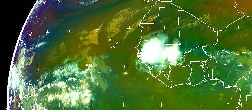
Here it comes.Lets see if this wave aliviates to some extent the drought situation that some of the Eastern Caribbean islands have.
0 likes


Re:
Gustywind wrote:Absolutely guys, i have some showers as you Abanjan, and the thunder is rumbling right now, tenacious wave in spite of the high shear values, if it's that in August or September we have much more to see yet , hope i'm wrong
time will tell!
It looks like the wave will be entering 30 knot shear instead of the 40 to 50 knot shear it endored the last 2 days. I think this large wave even though its very disorganized would of had a shot of being a depression if the shear was down to maybe 5 or 10 knots.
http://cimss.ssec.wisc.edu/tropic/real- ... g8shr.html
0 likes
-
srainhoutx

- S2K Supporter

- Posts: 6919
- Age: 68
- Joined: Sun Jan 14, 2007 11:34 am
- Location: Haywood County, NC
- Contact:
Re: Re:
boca wrote:Gustywind wrote:Absolutely guys, i have some showers as you Abanjan, and the thunder is rumbling right now, tenacious wave in spite of the high shear values
It looks like the wave will be entering 30 knot shear instead of the 40 to 50 knot shear it endored the last 2 days. I think this large wave even though its very disorganized would of had a shot of being a depression if the shear was down to maybe 5 or 10 knots.
http://cimss.ssec.wisc.edu/tropic/real- ... g8shr.html
follow the little vortex to SW Caribbean.
0 likes
-
Gustywind

- Category 5

- Posts: 12334
- Joined: Mon Sep 03, 2007 7:29 am
- Location: Baie-Mahault, GUADELOUPE
Re: Re:
boca wrote:Gustywind wrote:Absolutely guys, i have some showers as you Abanjan, and the thunder is rumbling right now, tenacious wave in spite of the high shear values
It looks like the wave will be entering 30 knot shear instead of the 40 to 50 knot shear it endored the last 2 days. I think this large wave even though its very disorganized would of had a shot of being a depression if the shear was down to maybe 5 or 10 knots.
http://cimss.ssec.wisc.edu/tropic/real- ... g8shr.html
Absolutely that's quite credible Boca
Humm concerning the shear no Boca always hugh values 40 kts right now
http://cimss.ssec.wisc.edu/tropic/real- ... g8shr.html
Amazing for a 49 kts trip, i'm a little amazed sometimes with only 25 kts of shear nothing and 40 kts and always tenacious, if for August we have 25kts of shear in some areas we should see at least a TD lol? don't tkink that i'm jocking
0 likes
-
Gustywind
- Category 5
- Posts: 12334
- Joined: Mon Sep 03, 2007 7:29 am
- Location: Baie-Mahault, GUADELOUPE
http://cimss.ssec.wisc.edu/tropic/real- ... g8sht.html
Don't except shear to abat strong strong westerlies 
Don't except shear to abat
0 likes
Re: Tropical Waves Between Lesser Antilles and West Africa
The islands are shredding it because it is shallow. That would be something if it made it to the west Caribbean and formed.
0 likes
-
Gustywind
- Category 5
- Posts: 12334
- Joined: Mon Sep 03, 2007 7:29 am
- Location: Baie-Mahault, GUADELOUPE
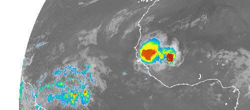
A-MA-ZING tonight and this morning, we're feeling the effects of this strong twave, numerous lightning, tstorms moderate showers and the thunder is rumbling seriously. I'm amazed my friends, it looks like a strong wave in September, thunderstorms are huge falling seriously' here. I jump out of my bed too
see what really happens. I don't know how the situation has evolved convection has increased tremendously perpahs, but for sure with have right now much more thant the water.... the scare of the strong tstorms. I monitor this system, i'm amazed given the shear map at midnight i was thinking about little showers with one weak tstorms...but sincerely the others carib residents keep watching it....
Nice regards Gustywind
I'm lucky no poweroutage for the moment so i try ti give you some info that we're experiencing the assaults of this tenacious, tremendous wave...
http://www.star.nesdis.noaa.gov/smcd/op ... SOUFIR.GIF
Convection has fired maybe during the night bursting and bursting!
see what really happens. I don't know how the situation has evolved convection has increased tremendously perpahs, but for sure with have right now much more thant the water.... the scare of the strong tstorms. I monitor this system, i'm amazed given the shear map at midnight
Nice regards Gustywind
I'm lucky no poweroutage for the moment so i try ti give you some info that we're experiencing the assaults of this tenacious, tremendous wave...
http://www.star.nesdis.noaa.gov/smcd/op ... SOUFIR.GIF
Convection has fired maybe during the night bursting and bursting!
0 likes
-
Gustywind
- Category 5
- Posts: 12334
- Joined: Mon Sep 03, 2007 7:29 am
- Location: Baie-Mahault, GUADELOUPE
Atlantic Tropical Weather Discussion
--------------------------------------------------------------------------------
000
AXNT20 KNHC 200549
TWDAT
TROPICAL WEATHER DISCUSSION
NWS TPC/NATIONAL HURRICANE CENTER MIAMI FL
205 AM EDT FRI JUN 20 2008
TROPICAL WEATHER DISCUSSION FOR NORTH AMERICA...CENTRAL
AMERICA...GULF OF MEXICO...CARIBBEAN SEA...NORTHERN SECTIONS OF
SOUTH AMERICA...AND ATLANTIC OCEAN TO THE AFRICAN COAST FROM THE
EQUATOR TO 32N. THE FOLLOWING INFORMATION IS BASED ON SATELLITE
IMAGERY...METEOROLOGICAL ANALYSIS...WEATHER OBSERVATIONS...AND
RADAR.
BASED ON 0000 UTC SURFACE ANALYSIS AND SATELLITE IMAGERY THROUGH
0515 UTC.
...TROPICAL WAVES...
A TROPICAL WAVE IS ALONG 59W/60W S OF 19N MOVING W NEAR 20 KT.
A BROAD AREA OF CYCLONIC TURNING IS ASSOCIATED WITH THE WAVE.
SFC OBSERVATIONS FROM THE LESSER ANTILLES INDICATES THAT THE
WAVE ALREADY CROSSED BARBADOS WHICH IS REPORTING SE WINDS 20 KT
AND MAINLY LIGHT SHOWERS. PRESSURES ARE FALLING 2 MB AHEAD OF
THE WAVE AXIS. THE WAVE IS GENERATING SCATTERED SHOWERS AND
TSTMS OVER THOSE ISLANDS BUT MAINLY BETWEEN GUADELOUPE AND
DOMINICA. THE MIMIC-TPW PRODUCT SHOWS THE WAVE VERY WELL WHERE A
GOOD SURGE OF MOISTURE IS NOTED. MOISTURE ASSOCIATED WITH THIS
WAVE IS EXPECTED TO REACH THE UK/US VIRGIN ISLANDS THIS MORNING
AND PUERTO RICO THROUGHOUT THE DAY...BRINGING AN INCREASE IN
SHOWER ACTIVITY AND GUSTY WINDS.
i was sleeping , but i understand why....maybe our friend HUC is feeling the worst effects because is from Basse Terre souther than me more ,to the center of the island. I hope the very best for you HUC, here it's amazing remembering a twave in September of the past year!
In addition i have gusts ahead the thunderstorms
CARIBBEAN...
A RIDGE/TROUGH PATTERN IS OBSERVED OVER THE CARIBBEAN SEA. THE
RIDGE COVERS THE WEST AND CENTRAL CARIBBEAN WHILE AN UPPER-LEVEL
TROUGH FROM THE CENTRAL ATLC HAS ITS BASE OVER THE FAR SE
CARIBBEAN AND THE WINDWARD ISLANDS. THE TROPICAL WAVE OVER THE
LESSER ANTILLES IS INTERACTING WITH THIS UPPER-LEVEL TROUGH. AS
A RESULTS...CONVECTION HAS SLIGHTLY INCREASED NEAR THE NORTHERN
END OF THE WAVE AXIS...From the TROPICAL WEATHER DISCUSSION
NWS TPC/NATIONAL HURRICANE CENTER MIAMI FL
205 AM EDT FRI JUN 20 2008
http://cimss.ssec.wisc.edu/tropic/real- ... g8shr.html
Damnnn the wave is crossing the islands with 30 to 40 kts for my untrained eyes ?or my eyes are deceiving me ?? it's an awesome scenario, imagine 10 to 15kts with this developped intensity! Given the map it has crossed with at least 35 kts of shear from west!
--------------------------------------------------------------------------------
000
AXNT20 KNHC 200549
TWDAT
TROPICAL WEATHER DISCUSSION
NWS TPC/NATIONAL HURRICANE CENTER MIAMI FL
205 AM EDT FRI JUN 20 2008
TROPICAL WEATHER DISCUSSION FOR NORTH AMERICA...CENTRAL
AMERICA...GULF OF MEXICO...CARIBBEAN SEA...NORTHERN SECTIONS OF
SOUTH AMERICA...AND ATLANTIC OCEAN TO THE AFRICAN COAST FROM THE
EQUATOR TO 32N. THE FOLLOWING INFORMATION IS BASED ON SATELLITE
IMAGERY...METEOROLOGICAL ANALYSIS...WEATHER OBSERVATIONS...AND
RADAR.
BASED ON 0000 UTC SURFACE ANALYSIS AND SATELLITE IMAGERY THROUGH
0515 UTC.
...TROPICAL WAVES...
A TROPICAL WAVE IS ALONG 59W/60W S OF 19N MOVING W NEAR 20 KT.
A BROAD AREA OF CYCLONIC TURNING IS ASSOCIATED WITH THE WAVE.
SFC OBSERVATIONS FROM THE LESSER ANTILLES INDICATES THAT THE
WAVE ALREADY CROSSED BARBADOS WHICH IS REPORTING SE WINDS 20 KT
AND MAINLY LIGHT SHOWERS. PRESSURES ARE FALLING 2 MB AHEAD OF
THE WAVE AXIS. THE WAVE IS GENERATING SCATTERED SHOWERS AND
TSTMS OVER THOSE ISLANDS BUT MAINLY BETWEEN GUADELOUPE AND
DOMINICA. THE MIMIC-TPW PRODUCT SHOWS THE WAVE VERY WELL WHERE A
GOOD SURGE OF MOISTURE IS NOTED. MOISTURE ASSOCIATED WITH THIS
WAVE IS EXPECTED TO REACH THE UK/US VIRGIN ISLANDS THIS MORNING
AND PUERTO RICO THROUGHOUT THE DAY...BRINGING AN INCREASE IN
SHOWER ACTIVITY AND GUSTY WINDS.
In addition i have gusts ahead the thunderstorms
CARIBBEAN...
A RIDGE/TROUGH PATTERN IS OBSERVED OVER THE CARIBBEAN SEA. THE
RIDGE COVERS THE WEST AND CENTRAL CARIBBEAN WHILE AN UPPER-LEVEL
TROUGH FROM THE CENTRAL ATLC HAS ITS BASE OVER THE FAR SE
CARIBBEAN AND THE WINDWARD ISLANDS. THE TROPICAL WAVE OVER THE
LESSER ANTILLES IS INTERACTING WITH THIS UPPER-LEVEL TROUGH. AS
A RESULTS...CONVECTION HAS SLIGHTLY INCREASED NEAR THE NORTHERN
END OF THE WAVE AXIS...From the TROPICAL WEATHER DISCUSSION
NWS TPC/NATIONAL HURRICANE CENTER MIAMI FL
205 AM EDT FRI JUN 20 2008
http://cimss.ssec.wisc.edu/tropic/real- ... g8shr.html
Damnnn the wave is crossing the islands with 30 to 40 kts for my untrained eyes ?or my eyes are deceiving me ?? it's an awesome scenario, imagine 10 to 15kts with this developped intensity! Given the map it has crossed with at least 35 kts of shear from west!
0 likes

Re: Tropical Waves Between Lesser Antilles and West Africa
Is it just me, but I really do not agree with this map, I am estimating windshear to be 20-25knots at the most across the central and western Caribbean by looking at the water vapor loop. Not unless they are taking into effect fast moving surface easterlies.

0 likes

Re: Tropical Waves Between Lesser Antilles and West Africa
Wouldn't shear always take into account winds at different heights and directions? Even if winds were higher aloft than the surface, it almost wouldn't be shear if the direction didn't change and the velocity gradient was linear.
0 likes


-
Gustywind
- Category 5
- Posts: 12334
- Joined: Mon Sep 03, 2007 7:29 am
- Location: Baie-Mahault, GUADELOUPE
Very conc entrated convection with this twave accompanying by less SAL ahead and warmer ssts, definitely interesting wave... 
http://cimss.ssec.wisc.edu/tropic/real- ... 8split.jpg
It should be very interresting, the shear tendency is indicating that wind are abating a bit near the cv islands:darrow:
http://cimss.ssec.wisc.edu/tropic/real- ... g8sht.html
http://cimss.ssec.wisc.edu/tropic/real- ... m7shr.html
Shear is low neat the wave and if she's traveling very south it could have a little window to sustained a nice complex of convective activity, but as usual we're far away let's see if it can mantain some decent convection!
AXNT20 KNHC 210534
TWDAT
TROPICAL WEATHER DISCUSSION
NWS TPC/NATIONAL HURRICANE CENTER MIAMI FL
805 PM EDT SAT JUN 21 2008
TROPICAL WEATHER DISCUSSION FOR NORTH AMERICA...CENTRAL
AMERICA...GULF OF MEXICO...CARIBBEAN SEA...NORTHERN SECTIONS OF
SOUTH AMERICA...AND ATLANTIC OCEAN TO THE AFRICAN COAST FROM THE
EQUATOR TO 32N. THE FOLLOWING INFORMATION IS BASED ON SATELLITE
IMAGERY...METEOROLOGICAL ANALYSIS...WEATHER OBSERVATIONS...AND
RADAR.
BASED ON 0000 UTC SURFACE ANALYSIS AND SATELLITE IMAGERY THROUGH
0445 UTC.
Humm, maybe a mistake in the date they mentionned 805 PM, i prefer AM, or my eyes are deceiving me????
0 likes
-
Gustywind
- Category 5
- Posts: 12334
- Joined: Mon Sep 03, 2007 7:29 am
- Location: Baie-Mahault, GUADELOUPE
000
AWCA82 TJSJ 210835
RWSVI
WEATHER SUMMARY FOR THE U.S. VIRGIN ISLANDS
NATIONAL WEATHER SERVICE SAN JUAN PR
435 AM AST SAT JUN 21 2008
VARIABLY TO PARTLY CLOUDY SKIES WERE OBSERVED ACROSS THE U.S.
VIRGIN ISLANDS OVERNIGHT. DOPPLER WEATHER RADAR DETECTED A FEW
LIGHT PASSING SHOWERS JUST TO THE NORTH OF ST THOMAS AND ADJACENT
ISLANDS EARLIER THIS MORNING. HOWEVER...LAND AREAS HAVE REMAINED
RAIN FREE AS OF 430 AM AST. WINDS WERE FROM THE EAST AT 10 TO 20
MPH.
LATEST SATELLITE IMAGES ARE SHOWING THE BEST MOISTURE ASSOCIATED
WITH THE TROPICAL WAVE THAT PASSED ON FRIDAY OVER THE LOCAL AREA...
NOW LOCATED SOUTH OF HISPANIOLA...OVER THE SOUTHWESTERN OUTER
WATERS OF THE LOCAL CARIBBEAN WATERS. AS THIS TROPICAL WAVE
CONTINUES TO MOVE WESTWARD AND AWAY FROM THE LOCAL AREA THIS
MORNING...WEATHER CONDITIONS WILL IMPROVE ACROSS THE LOCAL ISLANDS
WITH LIMITED SHOWER ACTIVITY EXPECTED FOR MUCH OF SATURDAY.
OVERALL...EXPECT A MIXTURE OF CLOUDS AND SUNSHINE THROUGHOUT THE
DAY WITH LIMITED SHOWER ACTIVITY FOR MOST OF THE LOCAL ISLANDS.
ALSO...MORE SUSPENDED AFRICAN DUST IS EXPECTED TODAY AS TROPICAL
WAVE MOVES OUT FROM THE FORECAST AREA...WHILE A WIND SURGE
TRAILING THE WAVE WILL MAKE BREEZY TO WINDY CONDITIONS FOR MUCH OF
THIS WEEKEND.
NEXT TROPICAL WAVE TO AFFECT THE LOCAL ISLANDS EXPECTED FOR LATE
SUNDAY NIGHT INTO MONDAY. FOR THIS PERIOD EXPECT MODERATE TO
LOCALIZED HEAVY SHOWERS AND SQUALLS TO AFFECT BOTH LAND AREAS AND
THE LOCAL COASTAL WATERS. ANOTHER WIND SURGE WILL ACCOMPANYING THIS
WAVE...WHICH WILL MAKE BREEZY TO WINDY CONDITIONS FOR THE FIRST
LATTER OF THE UPCOMING WEEK.
SMALL CRAFT ADVISORIES ARE IN EFFECT FOR THE THE CARIBBEAN
PASSAGES AND OFFSHORE CARIBBEAN WATERS AT LEAST THROUGH SATURDAY
EVENING. SMALL CRAFT SHOULD EXERCISE CAUTION ELSEWHERE. WIND
GENERATED WAVES AND EASTERLY SWELLS WILL CONTINUE TO AFFECT OUR
LOCAL COASTAL WATERS AS THESE WAVES AND WIND SURGES MOVE THROUGH
THE LOCAL AREA FOR THE NEXT SEVERAL DAYS.
$$
0 likes

-
cycloneye
- Admin
- Posts: 149508
- Age: 69
- Joined: Thu Oct 10, 2002 10:54 am
- Location: San Juan, Puerto Rico
Re: Tropical Waves Between Lesser Antilles and West Africa
2 PM Discussion from TPC:
TROPICAL WAVE IS ALONG 33W/34W S OF 16N MOVING W 15-20 KT. BROAD
LOW-MID LEVEL CYCLONIC TURNING IS EVIDENT ON VISIBLE SATELLITE
IMAGERY. LATEST ASCAT WIND DATA SUPPORTS THE WAVE POSITION.
UPPER LEVEL FEATURES CONTINUE TO KEEP MOST OF THE CONVECTION SW
OF THE AXIS. A SMALL CLUSTER OF MODERATE CONVECTION IS FROM
1N-2N BETWEEN 34-35W. ADDITIONAL CLUSTERS OF SCATTERED MODERATE
TO STRONG CONVECTION ARE WITHIN 200 NM AHEAD OF THE AXIS FROM
4N-8N.
http://www.storm2k.org/weather/hw3.php? ... hwvmetric=
0 likes
-
cycloneye
- Admin
- Posts: 149508
- Age: 69
- Joined: Thu Oct 10, 2002 10:54 am
- Location: San Juan, Puerto Rico
Re: Tropical Waves Between Lesser Antilles and West Africa
A good flareup but shear ahead will be the dagger.

0 likes
-
djones65
- Category 1

- Posts: 264
- Age: 60
- Joined: Mon Jun 20, 2005 12:05 am
- Location: Ocean Springs, MS
A ship report from 0500 UTC 22 June 2008 near 5.2N and 43.2W has WSW (250 degrees) winds at 12 knots and a pressure of 1012 mb. Probably indicative of the monsoon trough or ITCZ location, but interesting since it's in the middle of the deep convection over the central tropical Atlantic.
SHIP S 0500 5.20 -43.20 254 229 250 12.0 - 4.9 3.0 - - 29.88 -0.04 77.5 - - 12.4
It's from the National Data Buoy Center... http://www.ndbc.noaa.gov
SHIP S 0500 5.20 -43.20 254 229 250 12.0 - 4.9 3.0 - - 29.88 -0.04 77.5 - - 12.4
It's from the National Data Buoy Center... http://www.ndbc.noaa.gov
0 likes
Who is online
Users browsing this forum: Category5Kaiju, Old-TimeCane and 223 guests