
Hmmm...
"The environment is not severe shear wise"
"The shear out there is just way too strong"
"above average water temps in the EATL"
"the SST's in the Eastern Atlantic are continuing to run a bit below normal"
"the main threat is the SAL"
"Sal isn't that bad"
Guess I'm not the only one who's confused...
Huge African Wave To Enter Atlantic on July 1-2
Moderator: S2k Moderators
Forum rules

The posts in this forum are NOT official forecasts and should not be used as such. They are just the opinion of the poster and may or may not be backed by sound meteorological data. They are NOT endorsed by any professional institution or STORM2K. For official information, please refer to products from the National Hurricane Center and National Weather Service.
-
JonathanBelles
- Professional-Met

- Posts: 11430
- Age: 35
- Joined: Sat Dec 24, 2005 9:00 pm
- Location: School: Florida State University (Tallahassee, FL) Home: St. Petersburg, Florida
- Contact:
-
Extremeweatherguy

- Category 5

- Posts: 11095
- Joined: Mon Oct 10, 2005 8:13 pm
- Location: Florida
Re:
gatorcane wrote:Folks, it really doesn't matter what comes off Africa at this time. The shear out there is just way too strong and looks more like a winter-time setup. We are talking 50K+ shear in the MDR and strong westerlies that span the entire Atlantic basin. Check out how hostile the environment is out there at this time. Nonetheless, things should gradually become more favorable for development in 4-6 weeks.

yeah, shear is bad in some areas, but look at that area of 5-10 knot shear east of the islands and that pocket of 5-20 knot shear east of Florida and that pocket of 5-10 knot shear in the northern Gulf. All a system will need to do is find one of these pockets of lower shear and then it might have a decent shot at developing. That is why we should watch these waves closely in the coming weeks as they head westward (especially as the MJO Pulse that Joe Bastardi has been talking about works eastward into the Atlantic). If a system can squeeze its way into an area with low shear, high oceanic heat, and lots of moisture, then there is definitely a chance of it spinning up.
BTW: It should be noted that July systems are really not all that unusual. 12 of the last 15 hurricane seasons have featured at least one July system. The 1993, 2000 and 2001 seasons are the only exceptions.
0 likes

The wave does look pretty impressive and the GFS has been trying to develop it at times, ECM also does show the wave pretty clearly but doesn't do anything with it.
There is likely a layer of dry stable air and SAL to the north which would be a large problem and there is shear nearby presently though each feature on thier own wouldn't stop development the pair together could cause issues for any wave.
One thing that should be noted is the East Atlantic is still running decently above normal so the waves do have extra juice to get going.
Finally July systems aren't that rare at all...but Cape Verde systems in July thats another matter, at least in the first 15 days of the month.
0 likes
Re: Huge African Wave To Enter Atlantic within 24 Hours
Since most of the previous well-formed waves have dissipated I would say climatology and what we are seeing in front of us should prevail with this one as well.
0 likes
The difference maybe with this wave is that it seems to be coming out with a bit more energy then recent waves have done, it seems to have a greater area of voricity. Still you would have to suspect at this time of year nothing is likely to come of this system at least till it gets much further west.
0 likes
-
Ed Mahmoud
Re: Huge African Wave To Enter Atlantic within 24 Hours
12Z GFS, Canadian say yes. 12Z UK Met says no.
Of course, 12Z Canadian also suggests a near miss on Canada from a tropical or sub-tropical system, so it may be development happy

Of course, 12Z Canadian also suggests a near miss on Canada from a tropical or sub-tropical system, so it may be development happy
Last edited by Ed Mahmoud on Sun Jun 29, 2008 12:42 pm, edited 1 time in total.
0 likes
-
Eyewall
Re: Huge African Wave To Enter Atlantic within 24 Hours
I think we will see this happen remember the Gfs was right on traget with Arthur.And now other modles are starting to show the same thing so far the Gfs has been doing a good job this season. Water temperatures are warm and all we need is a big ridge of high pressure to keep the system moving west into the caribbean and all of us will be up all night. 
0 likes
-
'CaneFreak

- Category 5
- Posts: 1487
- Joined: Mon Jun 05, 2006 10:50 am
- Location: New Bern, NC
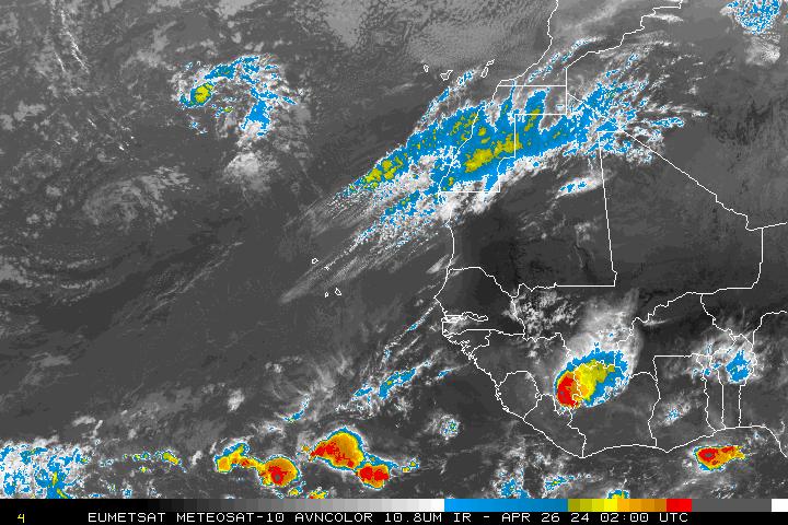
http://oiswww.eumetsat.org/IPPS/html/De ... /index.htm
All I can say is POOOOOOOF!!!! Do a 12 frame loop and you will see what I am talking about.....
All I can say is POOOOOOOF!!!! Do a 12 frame loop and you will see what I am talking about.....
0 likes
-
curtadams
- S2K Supporter

- Posts: 1122
- Joined: Sun Aug 28, 2005 7:57 pm
- Location: Orange, California
- Contact:
The GFS is predicting a system, but it's a hybrid, not a tropical system. The Canadian is predicting a tropical system but - well, it's the Canadian. Given that neither the NOGAPS or the UKM see anything whatsoever I'm expecting an exciting wave producing a lot of discussion but no official system. Perhaps something like that system 2 weeks ago where a circulation cut the ICTZ, moved north and died, just like any tropical cyclone, but was too weak to produce a formally closed circulation and never even got an invest.
0 likes

Re: Huge African Wave To Enter Atlantic within 24 Hours
I said it a little while ago and I will say it again: anything that tries to form near the 10th latitude and moves westward near the 10th or 12th N latitude straight west will have a better chance of surviving in the eastern Atlantic where shear is low and waters are warm enough. Any latitude gain will encounter cooler waters and shear, which I doubt it because of the persistent strong central Atlantic ridge that should keep anything moving straight west.
0 likes
any latitude will likely be picked up within the first 36hrs over water as there is a weakness to the north with a fair sized LP over the UK prehaps just helping to draw the wave feature a little further to the NW then otherwise would be the case, certainly some of the previous GFS runs have been mentioning this possiblity.
0 likes
-
Meso

- Category 5
- Posts: 1609
- Age: 39
- Joined: Mon Aug 09, 2004 12:14 pm
- Location: South Africa
- Contact:
Well it's not the Ukmet seeing nothing cause it does notice a strong open wave denting the ridge, which is something.The wave's convection has died down a bit but we will see in the next day or two what happens when it's over water.Even if nothing forms, let it be remembered that a numerous good looking waves have emerged over the past few weeks, should they continue to do so it's only a matter of time
0 likes
-
Ed Mahmoud
Re:
curtadams wrote:The GFS is predicting a system, but it's a hybrid, not a tropical system. The Canadian is predicting a tropical system but - well, it's the Canadian. Given that neither the NOGAPS or the UKM see anything whatsoever I'm expecting an exciting wave producing a lot of discussion but no official system. Perhaps something like that system 2 weeks ago where a circulation cut the ICTZ, moved north and died, just like any tropical cyclone, but was too weak to produce a formally closed circulation and never even got an invest.
In my unexpert and unofficial position, no matter what the phase diagram shows, if a closed low does develop over the Atlantic off Africa near 10ºN, it will almost certainly be a tropical system.
If, anything develops.
0 likes

Re: Huge African Wave To Enter Atlantic within 24 Hours
simeon9benjamin wrote:I think we will see this happen remember the Gfs was right on traget with Arthur.And now other modles are starting to show the same thing so far the Gfs has been doing a good job this season. Water temperatures are warm and all we need is a big ridge of high pressure to keep the system moving west into the caribbean and all of us will be up all night.
If the GFS is correct again,its the go-to model this season as far as I'm concerned
0 likes
Re: Huge African Wave To Enter Atlantic within 24 Hours
12z euro moves a strong wave or weak low pressure center westward right into P.R. by day ten, right near the 12th latitude, thus surviving that far west.
0 likes


-
Gustywind

- Category 5
- Posts: 12334
- Joined: Mon Sep 03, 2007 7:29 am
- Location: Baie-Mahault, GUADELOUPE
000
FXCA62 TJSJ 300856
AFDSJU
AREA FORECAST DISCUSSION
NATIONAL WEATHER SERVICE SAN JUAN PR
456 AM AST MON JUN 30 2008
THE NEXT SIGNIFICANT TROPICAL WAVE EXPECTED TO BRING AN INCREASE
IN WEATHER ACROSS THE ISLANDS IS CURRENTLY EXITING THE EAST COAST
OF AFRICA...AND IS EXPECTED TO REACH THE LOCAL AREA OVER THE
UPCOMING WEEKEND. THIS WAVE IS BEING FOLLOW BY A SECOND...WELL
ORGANIZED WAVE...THAT GFS BRINGS NEAR THE LEEWARD ISLANDS NEXT
MONDAY. OVERALL...PREVIOUS FORECAST REMAINS IN LINE WITH LATEST
MODEL GUIDANCE...SO ONLY A FEW MINOR TWEAKS MADE TO INHERITED
FORECAST PACKAGE THIS MORNING.
" bear watching"? interresting paragrah just to mention it...let's see what happens during the 72 h , maybe ours next guest???...should it verifies
0 likes
Who is online
Users browsing this forum: No registered users and 42 guests