TC Bertha
Moderator: S2k Moderators


I completely agree Miami. It won't turn NW because it won't get that strong because it will be entering cooler waters soon. The track would be interesting though if this became TD2 right now. What would NHC do? Would they almost completely ignore the model track and strength?
Also, welcome back.
Also, welcome back.
0 likes

Re: INVEST 92L in the Eastern Atlantic
[b]The posts in this forum are NOT official forecast and should not be used as such. They are just the opinion of the poster and may or may not be backed by sound meteorological data. They are NOT endorsed by any professional institution or storm2k.org. For official information, please refer to the NHC and NWS products
I also concur.If it stays weak=west it will go. Where it is now its just at the 80°F threshold.
http://www.ssd.noaa.gov/goes/east/catl/loop-wv.html
Also the tutt in the Eastern Caribbean will tear it apart too if it gets anywhere near that area.
I also concur.If it stays weak=west it will go. Where it is now its just at the 80°F threshold.
http://www.ssd.noaa.gov/goes/east/catl/loop-wv.html
Also the tutt in the Eastern Caribbean will tear it apart too if it gets anywhere near that area.
0 likes


-
gatorcane

- S2K Supporter

- Posts: 23708
- Age: 48
- Joined: Sun Mar 13, 2005 3:54 pm
- Location: Boca Raton, FL
Re: INVEST 92L in the Eastern Atlantic
Well MiamiWx great analysis as usual. Westward hoe our new invest goes. That snippet from NWS Miami is concerning regarding the long wave pattern featuring a deep subtropical ridge developing off the east coast of the US. Accuweather may just be on to something with their project "path" into the Bahamas. Alot can happen though. Still not expecting much for the next 3-4 days from this.
Last edited by gatorcane on Tue Jul 01, 2008 10:06 pm, edited 2 times in total.
0 likes
-
gatorcane
- S2K Supporter
- Posts: 23708
- Age: 48
- Joined: Sun Mar 13, 2005 3:54 pm
- Location: Boca Raton, FL
BTW here is what NWS Miami is saying and what MiamiWx posted above. Note that NWS Miami mentioned a possible EC trough for early next week but they have backed off. If the invest manages to bypass a weakness or two that it should see traversing the Central Atlantic things would get interesting to say the least with this kind of pattern:
LONG TERM...SATURDAY THROUGH TUESDAY...CONDITIONS WILL START TO
SHIFT THROUGH THIS PERIOD AS THE LONG WAVE TROUGH IS REPLACED BY A
DEEP LAYER DEVELOPING RIDGE. NOT ONLY THE AMOUNT OF AVAILABLE
MOISTURE WILL DIMINISH SLIGHTLY, BUT ALSO THE LOCAL AREA WILL BE
UNDER DEEPER EASTERLIES AND SO THE STEERING FLOW WILL RESULT IN
AFTERNOON CONVECTION CONCENTRATING MORE OVER INTERIOR AND WEST
COAST.
http://www.srh.noaa.gov/fwd/productview ... &version=0
Last edited by gatorcane on Tue Jul 01, 2008 10:10 pm, edited 1 time in total.
0 likes
Re: INVEST 92L in the Eastern Atlantic
gatorcane wrote:Well MiamiWx great analysis as usual. Westward hoe our new invest goes. That snippet from NWS Miami is concerning regarding the long wave pattern featuring a deep subtropical ridge developing off the east coast of the US. Accuweather may just be on to something with their project "path" into the Bahamas. Alot can happen though. Still not expecting much for the next 3-4 days from this.
Accuweather had their projected path into the Bahamas,do you have a link?
0 likes
-
gatorcane
- S2K Supporter
- Posts: 23708
- Age: 48
- Joined: Sun Mar 13, 2005 3:54 pm
- Location: Boca Raton, FL
Re: INVEST 92L in the Eastern Atlantic
boca wrote:gatorcane wrote:Well MiamiWx great analysis as usual. Westward hoe our new invest goes. That snippet from NWS Miami is concerning regarding the long wave pattern featuring a deep subtropical ridge developing off the east coast of the US. Accuweather may just be on to something with their project "path" into the Bahamas. Alot can happen though. Still not expecting much for the next 3-4 days from this.
Accuweather had their projected path into the Bahamas,do you have a link?
No link but Hurakan posted it in this thread at:
Tue Jul 01, 2008 1:29 pm
0 likes


Re: INVEST 92L in the Eastern Atlantic
gatorcane wrote:boca wrote:gatorcane wrote:Well MiamiWx great analysis as usual. Westward hoe our new invest goes. That snippet from NWS Miami is concerning regarding the long wave pattern featuring a deep subtropical ridge developing off the east coast of the US. Accuweather may just be on to something with their project "path" into the Bahamas. Alot can happen though. Still not expecting much for the next 3-4 days from this.
Accuweather had their projected path into the Bahamas,do you have a link?
No link but Hurakan posted it in this thread at:
Tue Jul 01, 2008 1:29 pm
http://www.accuweather.com/news-story.a ... &article=3
0 likes
-
MiamiensisWx
Re: INVEST 92L in the Eastern Atlantic
I'll add some final amends to my original post before I retire for the night.
Firstly, gator, I was referring to the fact that the timing of the eastern CONUS longwave trough "lifting out" has been repeatedly pushed further into the future by some models. Therefore, although the Southeast/Bermuda ridge will be nearly non-existant, the Azores ridge will be stronger. In other words, the low level ridging in the eastern Atlantic may temporarily keep the surface low of 92L on a more southerly course than depicted by the model guidance.
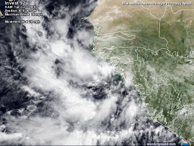
Secondly, I've changed my original diagnosis; I now believe 92L will almost certainly gain TD classification, and it has a fair chance to become Tropical Storm Bertha. Satellite imagery (http://oiswww.eumetsat.org/SDDI/html/images/out/SDDI-20080702-0245-MPEF-09-MPE-04-1237.jpg) indicates increasing structural organization, and there are persistent hints of a formative LLC developing. ASCAT data (http://manati.orbit.nesdis.noaa.gov/ascat_images/cur_50km/zooms/WMBas32.png) indicates that a "true" closed LLC has not formed, but NW, W, SW, SSE, and SE wind vectors are present. The only missing "ingredient" is easterly wind vectors. However, the formative circulation is becoming more well defined, and I definitely believe it will "close off" during tomorrow.
I would not be surprised if we see a TD late tomorrow or during the following day.
Firstly, gator, I was referring to the fact that the timing of the eastern CONUS longwave trough "lifting out" has been repeatedly pushed further into the future by some models. Therefore, although the Southeast/Bermuda ridge will be nearly non-existant, the Azores ridge will be stronger. In other words, the low level ridging in the eastern Atlantic may temporarily keep the surface low of 92L on a more southerly course than depicted by the model guidance.
Secondly, I've changed my original diagnosis; I now believe 92L will almost certainly gain TD classification, and it has a fair chance to become Tropical Storm Bertha. Satellite imagery (http://oiswww.eumetsat.org/SDDI/html/images/out/SDDI-20080702-0245-MPEF-09-MPE-04-1237.jpg) indicates increasing structural organization, and there are persistent hints of a formative LLC developing. ASCAT data (http://manati.orbit.nesdis.noaa.gov/ascat_images/cur_50km/zooms/WMBas32.png) indicates that a "true" closed LLC has not formed, but NW, W, SW, SSE, and SE wind vectors are present. The only missing "ingredient" is easterly wind vectors. However, the formative circulation is becoming more well defined, and I definitely believe it will "close off" during tomorrow.
I would not be surprised if we see a TD late tomorrow or during the following day.
0 likes

-
jaxfladude
- Category 5

- Posts: 1249
- Joined: Wed Aug 24, 2005 9:36 pm
- Location: Jacksonville, Fla
Maybe soon to be Bertha of '08 looks much more "attractive" than the Bertha of '96(she was one ugly Cane)......
Wait and see attitude from me....
 Almost the 4th of July!!
Fireworks the real kind and maybe the 'Cane kind.....will still be out to sea on the 4th!!!
Hope this is not a omen.....
Last edited by jaxfladude on Tue Jul 01, 2008 10:58 pm, edited 2 times in total.
0 likes
-
mattpetre
- Category 2

- Posts: 510
- Age: 54
- Joined: Mon Sep 19, 2005 3:20 pm
- Location: Missouri City,TX & Galleria
- Contact:
Welcome to another hurricane season... I have just spent the last hour reading the last days worth of posts and am happy to see this board as lively as ever. Looks like we have quite the anomaly on our hands. Too soon to make any predictions (since I usually make "homer" predictions for the Houston area anyway), but this does look to be an interesting week with the tropics.
Can anyone tell me how rare this strong of a wave is coming off the coast in July?
Can anyone tell me how rare this strong of a wave is coming off the coast in July?
0 likes

Re: INVEST 92L in the Eastern Atlantic
MiamiensisWx wrote:I'll add some final amends to my original post before I retire for the night.
Firstly, gator, I was referring to the fact that the timing of the eastern CONUS longwave trough "lifting out" has been repeatedly pushed further into the future by some models. Therefore, although the Southeast/Bermuda ridge will be nearly non-existant, the Azores ridge will be stronger. In other words, the low level ridging in the eastern Atlantic may temporarily keep the surface low of 92L on a more southerly course than depicted by the model guidance.
Secondly, I've changed my original diagnosis; I now believe 92L will almost certainly gain TD classification, and it has a fair chance to become Tropical Storm Bertha. Satellite imagery (http://oiswww.eumetsat.org/SDDI/html/images/out/SDDI-20080702-0245-MPEF-09-MPE-04-1237.jpg) indicates increasing structural organization, and there are persistent hints of a formative LLC developing. ASCAT data (http://manati.orbit.nesdis.noaa.gov/ascat_images/cur_50km/zooms/WMBas32.png) indicates that a "true" closed LLC has not formed, but NW, W, SW, SSE, and SE wind vectors are present. The only missing "ingredient" is easterly wind vectors. However, the formative circulation is becoming more well defined, and I definitely believe it will "close off" during tomorrow.
I would not be surprised if we see a TD late tomorrow or during the following day.
Welcome back Miami!! I am glad you rethought your earlier position with 92L, better late than never.
0 likes
Re:
mattpetre wrote:Welcome to another hurricane season... I have just spent the last hour reading the last days worth of posts and am happy to see this board as lively as ever. Looks like we have quite the anomaly on our hands. Too soon to make any predictions (since I usually make "homer" predictions for the Houston area anyway), but this does look to be an interesting week with the tropics.
Can anyone tell me how rare this strong of a wave is coming off the coast in July?
Very, very rare!!!!!! This might be going down for the record books if it named in the next couple of days, for forming so far east so early in the season.
Last edited by NDG on Tue Jul 01, 2008 11:26 pm, edited 1 time in total.
0 likes
Who is online
Users browsing this forum: No registered users and 15 guests