
Yep indeed there is so much uncertainty with this system, a really interesting early season storm though I have to admit!
I was expecting this sort of thing in Mid-August, not early July!
to be fair to Accuweather that track is nearly the same as the NHC, northern Caribbean islands are almost in the cone of uncertainty, not quite but close enough.
TC Bertha
Moderator: S2k Moderators

Re:
KWT wrote:Yep indeed there is so much uncertainty with this system, a really interesting early season storm though I have to admit!
I was expecting this sort of thing in Mid-August, not early July!
to be fair to Accuweather that track is nearly the same as the NHC, northern Caribbean islands are almost in the cone of uncertainty, not quite but close enough.
The NHC does not do seven-day forecasts. Five-day forecasts are still very difficult to get spot-on, let alone seven days out. Accuweather is only going to cause panic with its "forecast" of an NC/SC hit in a week, when the TPC/NHC hasn't even mentioned landfall.
0 likes
yeah true but a lot of the generally public will just extrap the NHC forecast anyway and besides I don't think too many people are going to be paying too much attention to Bertha right now anyway given how far east it is, I think people will start becoming more aware of it IF the NHC does start to show at least a risk of landfall.
0 likes

Re: Tropical Storm Bertha in East Atlantic
I'm generally not a fan of accuwx or their products. I have a problem that their cone appears smaller in the near term for instance.
But extending the dates is not necessarily a bad thing.... and highlighting the fact that nearly the entire east coast of north america is in the uncertainty cone now doesn't seem unreasonable at all to me.
But extending the dates is not necessarily a bad thing.... and highlighting the fact that nearly the entire east coast of north america is in the uncertainty cone now doesn't seem unreasonable at all to me.
0 likes

Re:
Chacor wrote:That's an unofficial slackuweather forecast. They should not be doing seven-day forecasts when even the NHC's three- to five-day forecast has a large cone of uncertainty. They're just going to cause panic. Don't take everything at face value and follow the NHC's guidance, that's the best.
Compare the NHC track:

NHC cone is closer to the islands.
0 likes
First Vis.images coming on now:
http://www.ssd.noaa.gov/goes/flt/t1/vis-l.jpg
Hmmm circulation still underneath the cconvection, tohugh it is on the Southern side of it it does look like its tucked in a little bit since about 9hrs ago where part of it was exposed. Not amazing looking right now but its holding its own in some pretty cool waters for tropical development.
Also looking at the SST's its only about 12hrs away from getting back into the warmer waters again.
0 likes

Interesting turn of events, and it shows that early model runs really cannot be trusted, especially when they overdo the intensity of a system (They should not have been considered because Bertha in no way was becoming a deep TS days after it emerged off Africa). These types of systems are ones you always must watch, weaker ones that keep sliding under the radar until they get to better conditions (ala Andrew, the series of events that caused Katrina's genesis). It worries me that it will get this close to the US now.
Also, I wouldn't really bet on it dissipating. I think folks are forgetting that this system isn't some disorganized Tropical Depression. Looking at visibles one can see it has a fairly healthy circulation and has always had one since emerging off Africa. I think if it would have dissipated it would have done so already. I like the NHC's track, but i doubt it'll ever get to 60 kts (especially since they forecast shear later). I like a consistent 40-50 kt intensity throughout their forecast period.
Also, I wouldn't really bet on it dissipating. I think folks are forgetting that this system isn't some disorganized Tropical Depression. Looking at visibles one can see it has a fairly healthy circulation and has always had one since emerging off Africa. I think if it would have dissipated it would have done so already. I like the NHC's track, but i doubt it'll ever get to 60 kts (especially since they forecast shear later). I like a consistent 40-50 kt intensity throughout their forecast period.
0 likes
-
Gustywind

- Category 5

- Posts: 12334
- Joined: Mon Sep 03, 2007 7:29 am
- Location: Baie-Mahault, GUADELOUPE
000
FXCA62 TJSJ 050735
AFDSJU
AREA FORECAST DISCUSSION
NATIONAL WEATHER SERVICE SAN JUAN PR
335 AM AST SAT JUL 5 2008
OF PARTICULAR INTEREST...TROPICAL STORM BERTHA CONTINUES TO CHURN
OUT IN THE TROPICAL ATLANTIC OCEAN...POSING ONLY A THREAT TO
SHIPPING LANES AT THIS TIME. THE SYSTEM SHOULD MAINTAIN A WESTWARD
TRACK FOR THE NEXT DAY AS IT PROPAGATES AROUND THE PERIPHERY OF
THE ATLANTIC SURFACE HIGH. GUIDANCE SUGGESTS AN EVENTUAL WEST-
NORTHWESTERLY TRACK WITH TIME...WHICH NOW PLACES THE FEATURE
MUCH CLOSER TO THE LOCAL ISLANDS BY WEDNESDAY OF NEXT WEEK. WILL
DEFER TO FUTURE FORECAST PACKAGES BEFORE INCREASING THE
PRECIPITATION ON WEDNESDAY UNTIL THE TRACK OF BERTHA IS MORE
CERTAIN.
.MARINE...
AS TROPICAL STORM BERTHA ADVANCES WITH A WESTWARD COMPONENT TOWARD
THE NORTHEAST CARIBBEAN BY THE MIDDLE OF NEXT WEEK...A DYNAMIC
FETCH SETUP COULD OCCUR AND GENERATE NORTHEASTERLY SWELLS ACROSS
THE LOCAL WATERS. ADDITIONALLY...A NEW AFRICAN EASTERLY WAVE IS
SEEN EXITING THE AFRICAN COAST WHICH COULD ADD TO A POSSIBLE SWELL
EVENT BY THE END OF THE NEXT WORK WEEK. IT IS IMPERATIVE TO
NOTE...HOWEVER THAT THIS IS A HIGHLY UNCERTAIN SOLUTION AT THIS
TIME DUE TO POSSIBLE TRACK ERRORS IN THE CURRENT FORECAST.
MARINERS ARE URGED TO STAY ABREAST OF THE LATEST UPDATES FROM THE
NATIONAL WEATHER SERVICE FOR THE MOST UP-TO-DATE INFORMATION.
0 likes
-
dixiebreeze

- S2K Supporter

- Posts: 5140
- Joined: Wed Sep 03, 2003 5:07 pm
- Location: crystal river, fla.
Re: Tropical Storm Bertha in East Atlantic
05/0545 UTC 16.3N 34.3W T3.0/3.0 BERTHA
Hanging in there this morning
Hanging in there this morning
0 likes
-
Blown Away

- S2K Supporter
- Posts: 10253
- Joined: Wed May 26, 2004 6:17 am
Re: Tropical Storm Bertha in East Atlantic
If the latest convective burst is over the LLC then Bertha is on the NHC track. If that burst is on the N side of the LLC then Bertha is tracking S of the NHC track. Bertha appears to be going almost due W, IMO.
http://www.ssd.noaa.gov/goes/flt/t1/loop-vis.html
http://www.ssd.noaa.gov/goes/flt/t1/loop-vis.html
0 likes

-
cycloneye
- Admin

- Posts: 149568
- Age: 69
- Joined: Thu Oct 10, 2002 10:54 am
- Location: San Juan, Puerto Rico
Re: Tropical Storm Bertha in East Atlantic
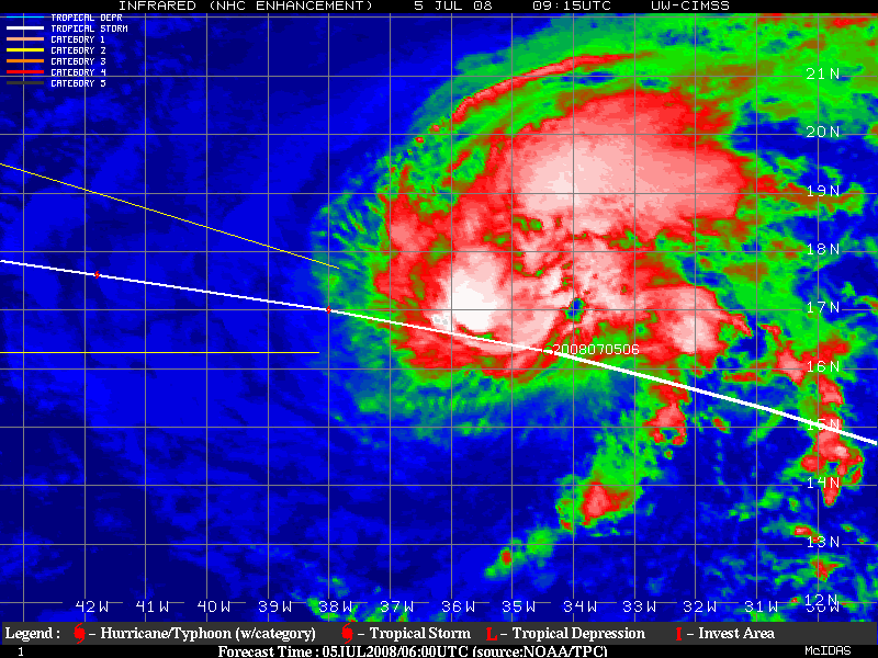
UW - CIMSS
ADVANCED DVORAK TECHNIQUE
ADT-Version 7.2.3
Tropical Cyclone Intensity Algorithm
----- Current Analysis -----
Date : 05 JUL 2008 Time : 111500 UTC
Lat : 16:38:20 N Lon : 35:58:29 W
CI# /Pressure/ Vmax
3.3 / 998.7mb/ 51.0kt
Final T# Adj T# Raw T#
(3hr avg)
3.3 3.4 3.4
Latitude bias adjustment to MSLP : +2.3mb
Center Temp : -24.8C Cloud Region Temp : -41.7C
Scene Type : SHEAR (0.04^ TO DG)
Positioning Method : FORECAST INTERPOLATION
Ocean Basin : ATLANTIC
Dvorak CI > MSLP Conversion Used : ATLANTIC
Tno/CI Rules : Constraint Limits : NO LIMIT
Weakening Flag : OFF
Rapid Dissipation Flag : OFF
0 likes
-
Blown Away
- S2K Supporter
- Posts: 10253
- Joined: Wed May 26, 2004 6:17 am
Well its estimated to be just a tiny bit south of 16.4N and pretty much 36W so yeah your not far wrong, pretty evident that the LLC is tucked in under the convection and the fact its flared up over the LLC rather to the north may be suggesting shear is starting to lessen just as it starts to get closer to the warmer waters.
0 likes
Who is online
Users browsing this forum: No registered users and 71 guests