Tropical Storm Bertha Model Runs
Moderator: S2k Moderators

Re: Tropical Storm Bertha Model Runs
Aric Dunn wrote:ROCK wrote:not going to get caught up in one model run right now. I personally look to the EURO for track and the GFDL. Still a long way away......
not getting caught up.. the synoptics set up is very important since all the models are still trending west .. im going to watch every model and analyze them all..
its all good Artic
0 likes
Re:
Aric Dunn wrote:well all day today the gfs has been trending more and more west and the other models seem to be following suit .. so im curious now... the trough is weaker and the ridge is stronger.. interesting..
or maybe B opens up due to SAL and a very stable environment in front of her....reminds of TD10 which turned into TD12 which turned into Katrina.....
0 likes


Re: Tropical Storm Bertha Model Runs
the 0Z NOGAPS also implies a threat to the far northeast caribbean
0 likes
-
vacanechaser

- Category 5

- Posts: 1461
- Joined: Wed Dec 03, 2003 9:34 pm
- Location: Portsmouth, Va
- Contact:
Re: Tropical Storm Bertha Model Runs
canefreak and aric are right... right into the carolinas!!! almost 12 years to the day... about 3 days late to 96's version... gonna be very interesting next week...

Jesse V. Bass III
http://www.vastormphoto.com
Hurricane Intercept Research Team
Jesse V. Bass III
http://www.vastormphoto.com
Hurricane Intercept Research Team
0 likes
-
hurricane
Re: Tropical Storm Bertha Model Runs
It looks like no one is out of the woods from this one. 
0 likes

Currently tabulating a table/graph of 06z intensity models. SHIPS calling for hurricane.
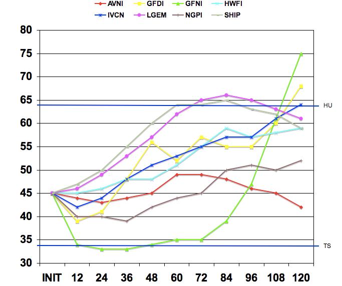
Refer to ftp://ftp.tpc.ncep.noaa.gov/atcf/nhc_techlist.dat for model names.
Code: Select all
TAU\MODEL   AVNI   GFDI   GFNI   HWFI   IVCN   LGEM   NGPI   SHIP
                            Wind speed in knots
INIT         45     45     45     45     45     45     45     45
  12         44     39     34     45     42     46     40     47
  24         43     41     33     46     44     49     40     50
  36         44     48     33     48     48     53     39     55
  48         45     56     34     48     51     57     42     60
  60         49     52     35     51     53     62     44     64
  72         49     57     35     55     55     65     45     64
  84         48     55     39     59     57     66     50     65
  96         46     55     47     57     57     65     51     63
  108        45     60     61     58     61     63     50     62
  120        42     68     75     59     64     61     52     59
Refer to ftp://ftp.tpc.ncep.noaa.gov/atcf/nhc_techlist.dat for model names.
0 likes

GFS looks like a Bertha 1996 re-duex, its quite scary how the 2 systems are starting to looking more and more similar!
The models really do seem to be keen on taking this very close to the USA, indeed the UKMO takes this system right into the Caribbean which is honestly stunning!
I think as long as it survives then we are going to have to keep sucvch a close eye on this system.
The models really do seem to be keen on taking this very close to the USA, indeed the UKMO takes this system right into the Caribbean which is honestly stunning!
I think as long as it survives then we are going to have to keep sucvch a close eye on this system.
0 likes

Re: Tropical Storm Bertha Model Runs
Latest run of the ECMWF looses the system north of the islands after 120hrs:
http://www.meteo.psu.edu/~gadomski/ECMW ... floop.html
http://www.meteo.psu.edu/~gadomski/ECMW ... floop.html
0 likes
Re: Tropical Storm Bertha Model Runs
New 6z GFS is further east and weaker with the system. New trough coming off the East coast in 5 to 7 days breaks down the West Atlantic Ridge:
500mb:
http://www.nco.ncep.noaa.gov/pmb/nwprod ... loop.shtml
Surface:
http://www.nco.ncep.noaa.gov/pmb/nwprod ... loop.shtml
500mb:
http://www.nco.ncep.noaa.gov/pmb/nwprod ... loop.shtml
Surface:
http://www.nco.ncep.noaa.gov/pmb/nwprod ... loop.shtml
Last edited by Thunder44 on Sat Jul 05, 2008 6:57 am, edited 1 time in total.
0 likes
-
Gustywind

- Category 5
- Posts: 12334
- Joined: Mon Sep 03, 2007 7:29 am
- Location: Baie-Mahault, GUADELOUPE
Re: Tropical Storm Bertha Model Runs
Jam151 wrote:the 0Z NOGAPS also implies a threat to the far northeast caribbean
And the UKMET? And the AMN...near Antigua and Barbuda very close to Guadeloupe too on its north side, and on St Marteen and St Barth really in eek:
0 likes
Yep the 06z is more of a threat to Bermuda as it happens.
Still there is clearly some uncertainty about whats going to happen givne the shifts in the models. The GFs has got a habit after 96hrs I note of breaking down ridges too fast and the same may apply to the 06z with the the way it breaks the Bermuda high.
Still there is clearly some uncertainty about whats going to happen givne the shifts in the models. The GFs has got a habit after 96hrs I note of breaking down ridges too fast and the same may apply to the 06z with the the way it breaks the Bermuda high.
0 likes
-
ftolmsteen

- Tropical Storm

- Posts: 122
- Joined: Mon Jun 25, 2007 6:34 am
- Location: Port Richey, FL
Re: Tropical Storm Bertha Model Runs
I'm assuming that the ukmet model has Bertha opening up to a wave being that far south from the majority of the models?
0 likes
-
cycloneye

- Admin

- Posts: 149286
- Age: 69
- Joined: Thu Oct 10, 2002 10:54 am
- Location: San Juan, Puerto Rico
Re: Tropical Storm Bertha Model Runs
06z GFDL curves more north at 62w.Maybe is seeing a trough at the east coast that may cause the track to go north at that point.
WHXX04 KWBC 051128
CHGQLM
ATTENTION...NATIONAL HURRICANE CENTER
NCEP COUPLED GFDL HURRICANE MODEL FORECAST MADE FOR
TROPICAL STORM BERTHA 02L
INITIAL TIME 6Z JUL 5
DISCLAIMER ... THIS INFORMATION IS PROVIDED AS GUIDANCE. IT
REQUIRES INTERPRETATION BY HURRICANE SPECIALISTS AND SHOULD
NOT BE CONSIDERED AS A FINAL PRODUCT. PLEASE SEE THE TPC/NHC
OFFICIAL FORECAST.
FORECAST STORM POSITION
HOUR LATITUDE LONGITUDE HEADING/SPEED(KT)
0 16.0 34.4 285./18.0
6 16.4 36.3 281./18.4
12 16.6 38.1 275./18.0
18 16.7 39.7 274./14.6
24 17.0 41.6 281./19.3
30 17.7 43.6 288./19.6
36 18.2 45.6 285./19.6
42 18.9 47.2 292./17.3
48 19.9 48.8 303./17.3
54 20.3 50.1 288./13.6
60 20.9 51.5 291./13.9
66 21.2 52.8 283./12.2
72 21.8 53.8 299./11.7
78 22.6 54.9 306./12.8
84 23.0 56.3 290./13.1
90 23.7 57.3 302./11.7
96 24.6 58.2 315./12.0
102 25.1 59.3 298./11.4
108 25.7 60.3 299./10.7
114 26.4 61.0 310./ 9.1
120 26.8 61.8 302./ 8.5
126 27.4 62.5 309./ 8.2
0 likes
Yep I think it probably does the same the GFS, don't the GFDL and the GFS use the same synoptic dats, therefore if one has overdone the trough then its highly highly likely the other has as well?
GFDL should see the system slide to the west of Bermuda but to the east of the USA I'd have thought.
GFDL should see the system slide to the west of Bermuda but to the east of the USA I'd have thought.
0 likes

Re: Tropical Storm Bertha Model Runs
Well, this mornings model suite hasn't really shed any light on the long term track. Seems the global models are struggling with the upper air pattern next weekend. The GFS, GFDL, CMC, and HWRF want to find a weakness in the ridge and turn Bertha N or NW into the Atlantic. On the other hand, the NOGAPs, UKMET, and Euro somewhat want to keep the storm on a more southerly route. It all boils down to the strength of the trough over the NE US next weekend which we probably won't know for a couple of more days. Here's the most ominous run - the 00Z NOGAPS which shows the ridge holding tough next weekend.
http://moe.met.fsu.edu/cgi-bin/ngptc2.cgi?time=2008070500&field=Sea+Level+Pressure&hour=Animation
http://moe.met.fsu.edu/cgi-bin/ngptc2.cgi?time=2008070500&field=Sea+Level+Pressure&hour=Animation
0 likes
-
Blown Away

- S2K Supporter

- Posts: 10253
- Joined: Wed May 26, 2004 6:17 am
Re: Tropical Storm Bertha Model Runs
ronjon wrote:Well, this mornings model suite hasn't really shed any light on the long term track. Seems the global models are struggling with the upper air pattern next weekend. The GFS, GFDL, CMC, and HWRF want to find a weakness in the ridge and turn Bertha N or NW into the Atlantic. On the other hand, the NOGAPs, UKMET, and Euro somewhat want to keep the storm on a more southerly route. It all boils down to the strength of the trough over the NE US next weekend which we probably won't know for a couple of more days. Here's the most ominous run - the 00Z NOGAPS which shows the ridge holding tough next weekend.
http://moe.met.fsu.edu/cgi-bin/ngptc2.cgi?time=2008070500&field=Sea+Level+Pressure&hour=Animation
At the end run, is the ridge building back in or weakening?
0 likes
The thing that we need to be aware is the GFS and models similar to it were dead keen on recurving the system into the first weakness but it just hasn't happened as they over-estimated the weakness, I think we have got to be aware that the exact same thing could happen with the 06z solution this time round as well.
0 likes
-
Derek Ortt
Who is online
Users browsing this forum: No registered users and 32 guests