
urgent - immediate broadcast requested Tornado Watch number 698 NWS Storm Prediction Center Norman OK 200 PM CDT Wed Jul 9 2003
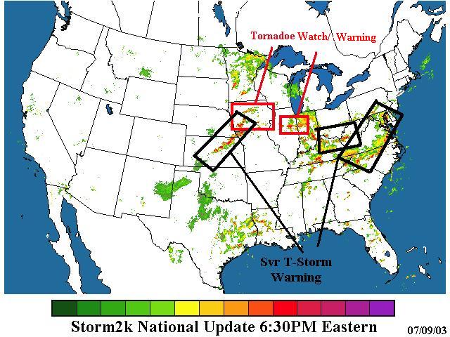
The NWS Storm Prediction Center has issued a Tornado Watch for portions of
Iowa
Effective this Wednesday afternoon and evening from 200 PM until 800 PM CDT.
Tornadoes... hail to 2.5 inches in diameter... thunderstorm wind gusts to 80 mph... and dangerous lightning are possible in these areas.
The Tornado Watch area is along and 95 statute miles east and west of a line from 35 miles northwest of Mason City Iowa to 5 miles south southeast of Lamoni Iowa.
Remember... a Tornado Watch means conditions are favorable for tornadoes and severe thunderstorms in and close to the watch area. Persons in these areas should be on the lookout for threatening weather conditions and listen for later statements and possible warnings.
Other watch information... continue... ww 695... ww 696... ww 697...
Discussion... temperatures have warmed into the mid 80s in swrn IA and will overspread the area as strong forcing spreads ewd across IA. 40-50 kt deep layer shear and mlcape values increasing to 2000 j/kg will be favorable for supercells. The greatest threat will be large hail and wind damage... though the shear/instability is also favorable for a few tornadoes.
Aviation... tornadoes and a few severe thunderstorms with hail surface and aloft to 2.5 inches. Extreme turbulence and surface wind gusts to 70 knots. A few cumulonimbi with maximum tops to 550. Mean storm motion vector 26035.
... Imy
The National Weather Service in Lincoln has issued a
* Tornado Warning for... Champaign County in east central Illinois
* until 645 PM CDT
* at 542 PM CDT... radar indicated a severe thunderstorm with strong rotation over Fisher... or about 11 miles west of Rantoul... moving southeast at 25 mph. This storm could produce a tornado at any time. In addition to the threat of a tornado... large hail and damaging winds can be expected with this storm. Go to a safe place now!
* The tornado is expected to be near... Ludlow Thomasboro Rantoul Champaign Urbana Gifford St. Joseph Philo
Other locations in this warning include... Lake of The Woods... Mahomet and Sidney.
Report severe weather or any storm damage to your local esda... or the nearest law enforcement agency... for relay to the National Weather Service. Stay tuned for later statements.
urgent - immediate broadcast requested Severe Thunderstorm Watch number 702 NWS Storm Prediction Center Norman OK 355 PM CDT Wed Jul 9 2003
The NWS Storm Prediction Center has issued a Severe Thunderstorm Watch for portions of
Southern and eastern Kansas northwestern Missouri extreme southeastern Nebraska
Effective this Wednesday afternoon and evening from 355 PM until 1000 PM CDT.
Hail to 2 inches in diameter... thunderstorm wind gusts to 70 mph... and dangerous lightning are possible in these areas.
The Severe Thunderstorm Watch area is along and 100 statute miles east and west of a line from 20 miles north northwest of Spickard Missouri to 45 miles east southeast of Medicine Lodge Kansas.
Remember... a Severe Thunderstorm Watch means conditions are favorable for severe thunderstorms in and close to the watch area. Persons in these areas should be on the lookout for threatening weather conditions and listen for later statements and possible warnings. Severe thunderstorms can and occasionally do produce tornadoes.
Other watch information... continue... ww 695... ww 696... ww 697... ww 698... ww 699... ww 700... ww 701...
Discussion... storms are expected to develop during the next hour or so as a shortwave trough and surface front moves ewd into the area. Mlcape values from 2000 to 3000 j/kg and 35 kt deep layer shear will be sufficient for storms with large hail and damaging winds.
Aviation... a few severe thunderstorms with hail surface and aloft to 2 inches. Extreme turbulence and surface wind gusts to 60 knots. A few cumulonimbi with maximum tops to 550. Mean storm motion vector 27030.
urgent - immediate broadcast requested Severe Thunderstorm Watch number 697 NWS Storm Prediction Center Norman OK 115 PM EDT Wed Jul 9 2003
The NWS Storm Prediction Center has issued a Severe Thunderstorm Watch for portions of
Delaware eastern Maryland southern New Jersey extreme southeast Pennsylvania southeast Virginia coastal waters
Effective this Wednesday afternoon and evening from 115 PM until 900 PM EDT.
Hail to 1 inch in diameter... thunderstorm wind gusts to 70 mph... and dangerous lightning are possible in these areas.
The Severe Thunderstorm Watch area is along and 85 statute miles east and west of a line from 60 miles northeast of Atlantic City New Jersey to 60 miles east of Danville Virginia.
Remember... a Severe Thunderstorm Watch means conditions are favorable for severe thunderstorms in and close to the watch area. Persons in these areas should be on the lookout for threatening weather conditions and listen for later statements and possible warnings. Severe thunderstorms can and occasionally do produce tornadoes.
Other watch information... continue... ww 695... ww 696...
Discussion... moderately to strongly unstable air mass is favorable for storms to develop/spread ewd across the area into the evening hours... as shortwave trough approaches from the west. Damaging winds will be the greatest threat... but strong instability will also support severe hail.
Aviation... a few severe thunderstorms with hail surface and aloft to 1 inch. Extreme turbulence and surface wind gusts to 60 knots. A few cumulonimbi with maximum tops to 550. Mean storm motion vector 27030.

