Estimated radius of max. wind based on IR :N/A km
Center Temp : -20.4C Cloud Region Temp : -58.1C
Scene Type : EYE
TC Bertha
Moderator: S2k Moderators


-
Mecklenburg
Re: Hurricane Bertha in Central Atlantic
the NHC even stated that it was such a coincidence that the hurricane formed on the same day a similar-named hurricane bertha formed in july 7 of 1996
0 likes

Re: Hurricane Bertha in Central Atlantic
Matt-hurricanewatcher wrote:Estimated radius of max. wind based on IR :N/A km
Center Temp : -20.4C Cloud Region Temp : -58.1C
Scene Type : EYE
What's the active time on that reading, btw?
Still, -20C, slightly warmer than what I'm seeing on that IR a few posts up. Still cloudy though as HURAKAN's visible shows.
Last edited by Chacor on Mon Jul 07, 2008 4:53 am, edited 1 time in total.
0 likes
-
Matt-hurricanewatcher
Re: Hurricane Bertha in Central Atlantic
Yes its weaker then Fabian, but it is centered very close to where it was when it was within the area. Also the nhc forecast bertha to follow his track...I also feel that this is likely to become a cat2 if the shear holds of.

0 likes
-
Matt-hurricanewatcher
Re: Hurricane Bertha in Central Atlantic
http://cimss.ssec.wisc.edu/tropic/adt/02L.txt
Here is the info it came off of.
Here is the info it came off of.
0 likes


-
vacanechaser

- Category 5

- Posts: 1461
- Joined: Wed Dec 03, 2003 9:34 pm
- Location: Portsmouth, Va
- Contact:
Re: Hurricane Bertha in Central Atlantic
nice eye hole... wow, what a difference in 24 hrs...
Jesse V. Bass III
http://www.vastormphoto.com
Hurricane Intercept Research Team
Jesse V. Bass III
http://www.vastormphoto.com
Hurricane Intercept Research Team
0 likes

-
Matt-hurricanewatcher
Re: Hurricane Bertha in Central Atlantic
UW - CIMSS
ADVANCED DVORAK TECHNIQUE
ADT-Version 7.2.3
Tropical Cyclone Intensity Algorithm
----- Current Analysis -----
Date : 07 JUL 2008 Time : 101500 UTC
Lat : 19:13:59 N Lon : 50:22:09 W
CI# /Pressure/ Vmax
4.1 / 986.9mb/ 67.4kt
Final T# Adj T# Raw T#
(3hr avg)
4.1 5.1 5.1
Latitude bias adjustment to MSLP : +1.5mb
Estimated radius of max. wind based on IR : 15 km
Center Temp : -0.9C Cloud Region Temp : -54.5C
Scene Type : EYE
Positioning Method : RING/SPIRAL COMBINATION
Ocean Basin : ATLANTIC
Dvorak CI > MSLP Conversion Used : ATLANTIC
Tno/CI Rules : Constraint Limits : NO LIMIT
Weakening Flag : OFF
Rapid Dissipation Flag : OFF
****************************************************
0 likes
-
Gustywind

- Category 5
- Posts: 12334
- Joined: Mon Sep 03, 2007 7:29 am
- Location: Baie-Mahault, GUADELOUPE
000
FXCA62 TJSJ 071017
AFDSJU
AREA FORECAST DISCUSSION
NATIONAL WEATHER SERVICE SAN JUAN PR
617 AM AST MON JUL 7 2008
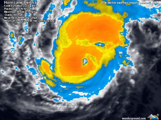
.DISCUSSION...UPGRADED HURRICANE BERTHA...BECOMES THE FIRST
HURRICANE OF THE 2008 ATLANTIC SEASON. AS OF 5 AM AST...THE CENTER
OF HURRICANE BERTHA WAS LOCATED NEAR LATITUDE 19.3
NORTH...LONGITUDE 50.2 WEST OR ABOUT 845 MILES...EAST OF THE
NORTHERN LEEWARD ISLANDS. BERTHA IS MOVING TOWARD THE WEST-NORTHWEST
NEAR 17 MPH. A CONTINUED WEST-NORTHWESTWARD MOTION WITH A GRADUAL
DECREASE IN FORWARD SPEED IS EXPECTED DURING THE NEXT COUPLE OF
DAYS...AS BERTHA REMAINS OVER THE WATERS OF THE CENTRAL TROPICAL
ATLANTIC. BASED ON THE LATEST FORECAST TRACK FROM THE NATIONAL
HURRICANE CENTER...BERTHA IS EXPECTED TO TRACK ABOUT 500 MILES
NORTHEAST OF THE LOCAL WATERS ON WEDNESDAY.
EVEN THOUGH...WE ARE NOT EXPECTING THIS SYSTEM TO AFFECT THE LOCAL
ISLANDS...DETACH MOISTURE ASSOCIATED TO THE SPIRAL BANDS OF
BERTHA...MOVING WESTWARD JUST AHEAD OF THE SYSTEM...WILL ARRIVE TO
THE EASTERN CARIBBEAN BY LATE THIS MORNING AND THEN ACROSS THE
LOCAL ISLANDS LATE THIS AFTERNOON AND DURING THE EVENING HOURS.
ONCE THIS MOISTURE GETS HERE...EXPECT SHOWERS AND ISOLATED
THUNDERSTORMS TO AFFECT MOST OF THE EASTERN HALF AND SOUTHERN
COASTS OF PUERTO RICO TONIGHT THROUGH TUESDAY MORNING. THE NW
SECTION OF PUERTO RICO WILL GET THE SHOWER AND THUNDERSTORM
ACTIVITY TUESDAY AFTERNOON.
MOISTURE TRAILING THE SYSTEM MAY AFFECT THE LOCAL ISLANDS THROUGH
LATE THURSDAY. BEGINNING FRIDAY...TYPICAL SUMMER WEATHER CONDITIONS
ARE EXPECTED FOR PUERTO RICO AND LOCAL ISLANDS THROUGH THE WEEKEND.
FXCA62 TJSJ 071017
AFDSJU
AREA FORECAST DISCUSSION
NATIONAL WEATHER SERVICE SAN JUAN PR
617 AM AST MON JUL 7 2008
.DISCUSSION...UPGRADED HURRICANE BERTHA...BECOMES THE FIRST
HURRICANE OF THE 2008 ATLANTIC SEASON. AS OF 5 AM AST...THE CENTER
OF HURRICANE BERTHA WAS LOCATED NEAR LATITUDE 19.3
NORTH...LONGITUDE 50.2 WEST OR ABOUT 845 MILES...EAST OF THE
NORTHERN LEEWARD ISLANDS. BERTHA IS MOVING TOWARD THE WEST-NORTHWEST
NEAR 17 MPH. A CONTINUED WEST-NORTHWESTWARD MOTION WITH A GRADUAL
DECREASE IN FORWARD SPEED IS EXPECTED DURING THE NEXT COUPLE OF
DAYS...AS BERTHA REMAINS OVER THE WATERS OF THE CENTRAL TROPICAL
ATLANTIC. BASED ON THE LATEST FORECAST TRACK FROM THE NATIONAL
HURRICANE CENTER...BERTHA IS EXPECTED TO TRACK ABOUT 500 MILES
NORTHEAST OF THE LOCAL WATERS ON WEDNESDAY.
EVEN THOUGH...WE ARE NOT EXPECTING THIS SYSTEM TO AFFECT THE LOCAL
ISLANDS...DETACH MOISTURE ASSOCIATED TO THE SPIRAL BANDS OF
BERTHA...MOVING WESTWARD JUST AHEAD OF THE SYSTEM...WILL ARRIVE TO
THE EASTERN CARIBBEAN BY LATE THIS MORNING AND THEN ACROSS THE
LOCAL ISLANDS LATE THIS AFTERNOON AND DURING THE EVENING HOURS.
ONCE THIS MOISTURE GETS HERE...EXPECT SHOWERS AND ISOLATED
THUNDERSTORMS TO AFFECT MOST OF THE EASTERN HALF AND SOUTHERN
COASTS OF PUERTO RICO TONIGHT THROUGH TUESDAY MORNING. THE NW
SECTION OF PUERTO RICO WILL GET THE SHOWER AND THUNDERSTORM
ACTIVITY TUESDAY AFTERNOON.
MOISTURE TRAILING THE SYSTEM MAY AFFECT THE LOCAL ISLANDS THROUGH
LATE THURSDAY. BEGINNING FRIDAY...TYPICAL SUMMER WEATHER CONDITIONS
ARE EXPECTED FOR PUERTO RICO AND LOCAL ISLANDS THROUGH THE WEEKEND.
0 likes
-
Gustywind
- Category 5
- Posts: 12334
- Joined: Mon Sep 03, 2007 7:29 am
- Location: Baie-Mahault, GUADELOUPE
AT 5 AM AST...BERTHA BECOMES THE FIRST HURRICANE OF THE 2008
000
AWCA82 TJSJ 070856
RWSVI
WEATHER SUMMARY FOR THE U.S. VIRGIN ISLANDS
NATIONAL WEATHER SERVICE SAN JUAN PR
456 AM AST MON JUL 7 2008
ATLANTIC SEASON. THE CENTER OF BERTHA WAS LOCATED NEAR LATITUDE
19.3 NORTH... LONGITUDE 50 WEST OR ABOUT 845 MILES...EAST OF THE
NORTHERN LEEWARD ISLANDS...MOVING TOWARD THE WEST NORTHWEST AT 17
MPH. MAXIMUM SUSTAINED WINDS WERE NEAR 75 MPH WITH HIGHER GUSTS.
BASED ON THE LATEST FORECAST FROM THE NATIONAL HURRICANE
CENTER...THIS SYSTEM WILL PASS WELL NORTHEAST OF THE LOCAL ISLANDS
BY THE MIDDLE OF THE WEEK. HOWEVER...DUE TO THE LONG TERM TRACK
ERRORS...THIS SYSTEM WILL BE CLOSELY MONITORED AS IT CONTINUES
ACROSS THE TROPICAL ATLANTIC.
0 likes

Re: Hurricane Bertha in Central Atlantic
Looking at it early this morning....two things come to mind....Bertha seems to be stronger than 65 kt...and I am starting to like Bertha's chances to possibly become a major. I didn't think it would be this strong so fast.
0 likes
-
Matt-hurricanewatcher
Re: Hurricane Bertha in Central Atlantic

It would not suprize me if it was near 70 knots.
Last edited by Matt-hurricanewatcher on Mon Jul 07, 2008 6:34 am, edited 1 time in total.
0 likes
Who is online
Users browsing this forum: No registered users and 30 guests