TC Bertha
Moderator: S2k Moderators
-
brunota2003

- S2K Supporter

- Posts: 9476
- Age: 35
- Joined: Sat Jul 30, 2005 9:56 pm
- Location: Stanton, KY...formerly Havelock, NC
- Contact:

-
senorpepr

- Military Met/Moderator

- Posts: 12542
- Age: 43
- Joined: Fri Aug 22, 2003 9:22 pm
- Location: Mackenbach, Germany
- Contact:
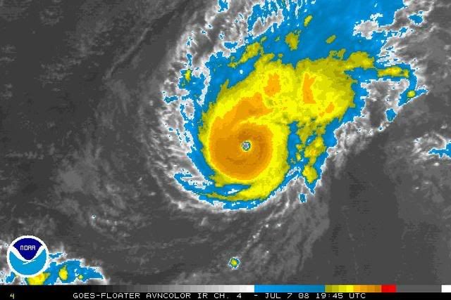
I just did a quick Dvorak estimate myself. I notice the eye is shrinking. It was running around 20nm earlier this morning. Now, I'm averaging around 12-13nm. No significant change to the distance between the center and the CDO edge.
T5.0/5.0/D2.0 24HRS seems reasonable to me. (90KT / 970 hPa) Considering everything, I wouldn't be too surprised to see this number edge up in the next few hours.
T5.0/5.0/D2.0 24HRS seems reasonable to me. (90KT / 970 hPa) Considering everything, I wouldn't be too surprised to see this number edge up in the next few hours.
0 likes
-
MiamiensisWx
Re: Hurricane Bertha in Central Atlantic
The following post is NOT an official prognosis.
I now believe Bertha has a very good chance to attain major hurricane intensity (<96 kt) today. Originally, I anticipated that mid level dry air would have likely prevented further intensification beyond solid Category 2 intensity, but it does not appear to be the case. The upper air environment remains ideal for additional deepening, with upper level diffluence and divergence that will likely good over the next ~24-36 hours. Additionally, Bertha is entering even more substantive oceanic heat content, and it will eventually cross the 28 C isotherm (SST) as well. Data strongly suggests that structural organization will continue, and with the TC's small wind radii, the current ATCF operational best track intensity of 90 kt is likely too low. However, the TC is not a major hurricane at this time, especially because of the fact that the strongest winds may not be mixing to the surface.
http://www.ssd.noaa.gov/goes/east/tatl/loop-avn.html
Satellite data succinctly offers evidence that Bertha's forward movement is decreasing, and the TC is starting to turn back to the west. Bertha is currently bypassing the TUTT in the central Atlantic, which induced a weakness in the upper levels and resulted in Bertha's recent brief NW movement. 500-850 mb streamline analysis indicates the presence of the strong upper level Bermuda ridge, which is amplifying as a H5 shortwave trough moves east across the Southeast. After the shortwave deepens over the next several hours, it will "lift out" to the NE, leaving a weaker and flatter H5 ridge extending west into the W Atlantic and Southeast. Around ~36-48 hours out, the operational GFS and some additional models build a strong H5 ridge into the Southwest CONUS, while a very large block eventually builds over Alaska and replaces the strong H5 low/vort max in the region. The amplification of the upstream pattern eventually results in a broad H5 trough moving over the Northeast, which will be the key for Bertha's final recurvature ~72 hours out. The evolution of the current shortwave and the Pacific pattern; the timing of the next trough in the East; and the movement of Bertha will play a significant role in the future track of the TC and the length of a potential stall. It is interesting and important to note that the Euro and the operational GFS are in agreement with the amplification of the Pacific pattern, but some of the GFS ensembles are more progressive with the pattern and depict a more "muted" evolution.
Overall, Bertha will likely continue to turn west over the next several hours as the H5 Bermuda ridge intensifies to the north. My thoughts remain unchanged and unaltered from yesterday, and I continue to anticipate a track between Bermuda and the Southeast coast. However, as the pattern becomes clearer, I feel that the threat to the Southeast has decreased slightly since yesterday. Bermuda faces a very significant threat from Bertha, and a plausible track ranging from east of the Southeast to just W of Bermuda (ala Fabian '03 in regards to angle of approach) remains equally possible. Considerable uncertainity remains in regards to the track and the possibility of a stall between Bermuda and the Southeast, though a stall or "slow down" is becoming increasingly possible. I continue to anticipate a track W of the current model "cluster", and the BAM/BAMD models are likely depicting a more realistic solution, though I don't expect a track as far west as the Bahamas at all. All residents in Bermuda are advised to focus on the cone instead of the line for the three day and five day forecasts at all times. Completion of seasonal preparations is strongly encouraged.
Last edited by MiamiensisWx on Mon Jul 07, 2008 6:29 pm, edited 1 time in total.
0 likes
-
OuterBanker
- S2K Supporter
- Posts: 1761
- Joined: Wed Feb 26, 2003 10:53 am
- Location: Nags Head, NC
- Contact:
-
MiamiensisWx
Re: Hurricane Bertha in Central Atlantic
MiamiensisWx wrote:The following post is NOT an official prognosis.
I now believe Bertha has a very good chance to attain major hurricane intensity (<96 kt) today. Originally, I anticipated that mid level dry air would have likely prevented further intensification beyond solid Category 2 intensity, but it does not appear to be the case. The upper air environment remains ideal for additional deepening, with upper level diffluence and divergence that will likely good over the next ~24-36 hours. Additionally, Bertha is entering even more substantive oceanic heat content, and it will eventually cross the 28 C isotherm (SST) as well. Data strongly suggests that structural organization will continue, and with the TC's small wind radii, the current ATCF operational best track intensity of 90 kt is likely too low. However, the TC is not a major hurricane at this time, especially because of the fact that the strongest winds may not be mixing to the surface.
http://www.ssd.noaa.gov/goes/east/tatl/loop-avn.html
Satellite data succintly offers evidence that Bertha's forward movement is decreasing, and the TC is starting to turn back to the west. Bertha is currently bypassing the TUTT in the central Atlantic, which induced a weakness in the upper levels and resulted in Bertha's recent brief NW movement. 500-850 mb streamline analysis indicates the presence of the strong upper level Bermuda ridge, which is amplifying as a H5 shortwave trough moves east across the Southeast. After the shortwave deepens over the next several hours, it will "lift out" to the NE, leaving a weaker and flatter H5 ridge extending west into the W Atlantic and Southeast. Around ~36-48 hours out, the operational GFS and some additional models build a strong H5 ridge into the Southwest CONUS, while a very large block eventually builds over Alaska and replaces the strong H5 low/vort max in the region. The amplification of the upstream pattern eventually results in a broad H5 trough moving over the Northeast, which will be the key for Bertha's final recurvature ~72 hours out. The evolution of the current shortwave and the Pacific pattern; the timing of the next trough in the East; and the movement of Bertha will play a significant role in the future track of the TC and the length of a potential stall. It is interesting and important to note that the Euro and the operational GFS are in agreement with the amplification of the Pacific pattern, but some of the GFS ensembles are more progressive with the pattern and depict a more "muted" evolution.
Overall, Bertha will likely continue to turn west over the next several hours as the H5 Bermuda ridge intensifies to the north. My thoughts remain unchanged and unaltered from yesterday, and I continue to anticipate a track between Bermuda and the Southeast coast. However, as the pattern becomes clearer, I feel that the threat to the Southeast has decreased slightly since yesterday. Bermuda faces a very significant threat from Bertha, and a plausible track ranging from east of the Southeast to just W of Bermuda (ala Fabian '03 in regards to angle of approach) remains equally possible. Considerable uncertainity remains in regards to the track and the possibility of a stall between Bermuda and the Southeast, though a stall or "slow down" is becoming increasingly possible. I continue to anticipate a track W of the current model "cluster", and the BAM/BAMD models are likely depicting a more realistic solution, though I don't expect a track as far west as the Bahamas at all. All residents in Bermuda are advised to focus on the cone instead of the line for the three day and five day forecasts at all times. Completion of seasonal preparations is strongly encouraged.
...and this is likely a major hurricane (100 kt) now. Period.
http://www.storm2k.org/phpbb2/viewtopic.php?p=1730988#p1730988
Thoughts and comments on this analysis are welcome.
Last edited by MiamiensisWx on Mon Jul 07, 2008 3:23 pm, edited 2 times in total.
0 likes

Re: Hurricane Bertha in Central Atlantic
cycloneye wrote:This thread has jumped to the 5th thread with most pages.It surpassed the Charley thread that had 124 pages.Next goal to break will be the Frances thread at 187 pages.
No surprise here.
Enthusiasts have anxiously awaited the season and a July CV storm that attains Hurricane status certainly provides something to follow.
Its been a long off-season.
0 likes


-
'CaneFreak

- Category 5

- Posts: 1487
- Joined: Mon Jun 05, 2006 10:50 am
- Location: New Bern, NC
This is not a cat 3 hurricane. It is just not. The cloud tops are not cold enough around the center for this to be a cat 3 hurricane. If I were to guess at the intensity, I would say this is a 95 knot Category 2 based on the intensity estimates I have seen posted. Oh and let me stress this....this hurricane will be going out to sea...the US can breathe a sigh of relief but our friends in Bermuda need to be preparing NOW because this thing could wreak havoc on their little island.
0 likes
-
brunota2003
- S2K Supporter
- Posts: 9476
- Age: 35
- Joined: Sat Jul 30, 2005 9:56 pm
- Location: Stanton, KY...formerly Havelock, NC
- Contact:

Re:
'CaneFreak wrote:This is not a cat 3 hurricane. It is just not. The cloud tops are not cold enough around the center for this to be a cat 3 hurricane. If I were to guess at the intensity, I would say this is a 95 knot Category 2 based on the intensity estimates I have seen posted. Oh and let me stress this....this hurricane will be going out to sea...the US can breathe a sigh of relief but our friends in Bermuda need to be preparing NOW because this thing could wreak havoc on their little island.
You don't know how strong it is. I don't know how strong it is. The national hurricane center doesn't know how strong it is. It could be 70 kts or 120kts, or somewhere inbetween.
0 likes
-
'CaneFreak
- Category 5
- Posts: 1487
- Joined: Mon Jun 05, 2006 10:50 am
- Location: New Bern, NC
Re:
Scorpion wrote:Cloud tops should cool further once nightfall arrives
Exactly....I look for a 110 knot Category 3 tonight at 11 if the trend continues....jmo...
0 likes


Yeah the cloud tops aren't quite deep enough yet but I think they may get sa little deeper early hours tomorrow with another 6-12hrs strengthening, higher heat content and also night-time cooling.
PS, hurricane Dean record page length had recon added as well as the model thread, I think we could beat Wilma...
PS, hurricane Dean record page length had recon added as well as the model thread, I think we could beat Wilma...
0 likes
-
MiamiensisWx
Re:
'CaneFreak wrote:This is not a cat 3 hurricane. It is just not. The cloud tops are not cold enough around the center for this to be a cat 3 hurricane. If I were to guess at the intensity, I would say this is a 95 knot Category 2 based on the intensity estimates I have seen posted. Oh and let me stress this....this hurricane will be going out to sea...the US can breathe a sigh of relief but our friends in Bermuda need to be preparing NOW because this thing could wreak havoc on their little island.
I concur with the bolded portion.
In regards to the strength, I did not believe it was stronger than Cat 2 status until I reviewed the very latest data over the past few minutes. I agree that the strongest winds were likely not mixing to the surface earlier, but that may be changing now.
Last edited by MiamiensisWx on Mon Jul 07, 2008 3:29 pm, edited 1 time in total.
0 likes

Re:
'CaneFreak wrote:This is not a cat 3 hurricane. It is just not. The cloud tops are not cold enough around the center for this to be a cat 3 hurricane. If I were to guess at the intensity, I would say this is a 95 knot Category 2 based on the intensity estimates I have seen posted. Oh and let me stress this....this hurricane will be going out to sea...the US can breathe a sigh of relief but our friends in Bermuda need to be preparing NOW because this thing could wreak havoc on their little island.
You can use lack of colder cloud tops around the eye as a reason to keep this a Cat 2, if you want to be conservative. I wouldn't be suprised if NHC has it just Cat 2 in 5pm advisory.
0 likes
-
'CaneFreak
- Category 5
- Posts: 1487
- Joined: Mon Jun 05, 2006 10:50 am
- Location: New Bern, NC
Re: Re:
RL3AO wrote:'CaneFreak wrote:This is not a cat 3 hurricane. It is just not. The cloud tops are not cold enough around the center for this to be a cat 3 hurricane. If I were to guess at the intensity, I would say this is a 95 knot Category 2 based on the intensity estimates I have seen posted. Oh and let me stress this....this hurricane will be going out to sea...the US can breathe a sigh of relief but our friends in Bermuda need to be preparing NOW because this thing could wreak havoc on their little island.
You don't know how strong it is. I don't know how strong it is. The national hurricane center doesn't know how strong it is. It could be 70 kts or 120kts, or somewhere inbetween.
Your right. I don't know how strong it is. BUT, I do know this....as many major hurricanes as I have seen in my life, I have NEVER seen a category 3 hurricane with -60C cloud tops surrounding the center. NEVER. There needs to be some -80s for me to believe it is a cat 3.
0 likes
Who is online
Users browsing this forum: No registered users and 39 guests