
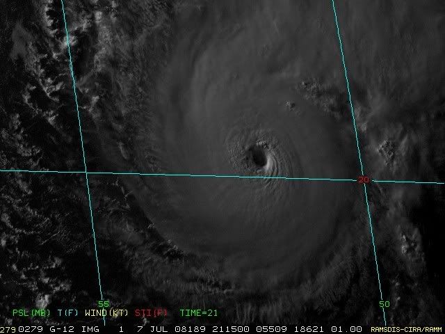
Wow that looks amazing right now, not really all that surprising its a major hurricane right now, you can really see the staadium effect as well!
Perfect circular CDO, amazing looking hurricane, esp when we consider its JULY!
TC Bertha
Moderator: S2k Moderators
-
Matt-hurricanewatcher
Re: Hurricane Bertha in Central Atlantic=5 PM=115 mph,948 mbs
Looks like emily at near her peak, the only difference is that she had a ring of red.
0 likes
-
tolakram
- Admin

- Posts: 20179
- Age: 62
- Joined: Sun Aug 27, 2006 8:23 pm
- Location: Florence, KY (name is Mark)
Re: Hurricane Bertha in Central Atlantic=5 PM=115 mph,948 mbs
Those cloud tops in the latest visual are high enough to register red (look close, 3 or 4 red pixels  ).
).

Looking at the AVN it appears Bertha has been going through waves of strengthening as deep convection fires near the center, spreads out and the tops warm, then another burst starts. I suspect it's beginning another burst, it will be interesting to see how strong it can get.
Looking at the AVN it appears Bertha has been going through waves of strengthening as deep convection fires near the center, spreads out and the tops warm, then another burst starts. I suspect it's beginning another burst, it will be interesting to see how strong it can get.
0 likes

Re: Hurricane Bertha in Central Atlantic=5 PM=115 mph,948 mbs
Wow. I'm stunned. Its not as if Bertha had ideal conditions for rapid deepening, and it might even suggest that Bertha could have been stronger throughout its life than indicated. And its not question its a major....a storm does not need red and black cloud tops to be considered a major...usually if a storm has red and black IR cloudtops with Bertha's presentation, its an upper end Cat4 or Cat5.
0 likes
-
hurricanefloyd5

- Category 5

- Posts: 1659
- Age: 45
- Joined: Sun May 02, 2004 10:53 am
- Location: Spartanburg
- Contact:
Re: Hurricane Bertha in Central Atlantic=5 PM=115 mph,948 mbs
that high is going to strenghten again alittle bit right?????
0 likes
-
cycloneye

- Admin
- Posts: 149291
- Age: 69
- Joined: Thu Oct 10, 2002 10:54 am
- Location: San Juan, Puerto Rico
Re: Hurricane Bertha in Central Atlantic=5 PM=115 mph,948 mbs
Last chance for all to look at the stadium effect as sun is going down.
0 likes
Re: Hurricane Bertha in Central Atlantic=5 PM=115 mph,948 mbs
In addition to Bertha's intensity, it should also be noted that Bertha is moving more northerly now. An overlay of the forecast points on the NHC floater shows Bertha is starting to track well north of the forecast points.
0 likes

-
MiamiensisWx
Re: Hurricane Bertha in Central Atlantic
400-850 mb streamline analysis still suggests a possible turn to the west:
http://cimss.ssec.wisc.edu/tropic/real-time/atlantic/winds/wg8dlm3.html
http://cimss.ssec.wisc.edu/tropic/real-time/atlantic/winds/wg8dlm3.html
0 likes
-
HURAKAN

- Professional-Met

- Posts: 46084
- Age: 39
- Joined: Thu May 20, 2004 4:34 pm
- Location: Key West, FL
- Contact:
Take the pleasure of looking at this loop: http://rammb.cira.colostate.edu/product ... 030800.GIF
Bertha at its best!!
Bertha at its best!!
0 likes
-
weatherguru18
Re: Hurricane Bertha in Central Atlantic
IMO, a recon won't be sent. Budget far too tight with a very long season ahead. Might be wrong on that. With a major forming this early in an area where tropical storms are rare at best does not bode well for this season. Those waters are awefully fertile.
0 likes

Re: Hurricane Bertha in Central Atlantic
MiamiensisWx wrote:400-850 mb streamline analysis still suggests a possible turn to the west:
http://cimss.ssec.wisc.edu/tropic/real-time/atlantic/winds/wg8dlm3.html
I posted that earlier but go no response. Why to the models/NHC have this turn so quickly? Its in the weakness right now and going NW. Why won't it turn west later tonight/tomorrow?
0 likes
-
HURAKAN
- Professional-Met
- Posts: 46084
- Age: 39
- Joined: Thu May 20, 2004 4:34 pm
- Location: Key West, FL
- Contact:
Re: Hurricane Bertha in Central Atlantic
RL3AO wrote:MiamiensisWx wrote:400-850 mb streamline analysis still suggests a possible turn to the west:
http://cimss.ssec.wisc.edu/tropic/real-time/atlantic/winds/wg8dlm3.html
I posted that earlier but go no response. Why to the models/NHC have this turn so quickly? Its in the weakness right now and going NW. Why won't it turn west later tonight/tomorrow?
If you press "Zoom" you get this:

0 likes
-
Cryomaniac
- Category 5
- Posts: 1289
- Joined: Tue Aug 15, 2006 2:26 pm
- Location: Newark, Nottinghamshire, UK
- Contact:
Re: Hurricane Bertha in Central Atlantic
weatherguru18 wrote:With a major forming this early in an area where tropical storms are rare at best does not bode well for this season. Those waters are awefully fertile.
I've got to agree with that, unfortunately. I think this season could be pretty hyperactive.
0 likes
-
cheezyWXguy

- Category 5
- Posts: 6282
- Joined: Mon Feb 13, 2006 12:29 am
- Location: Dallas, TX
Re: Hurricane Bertha in Central Atlantic
RL3AO wrote:MiamiensisWx wrote:400-850 mb streamline analysis still suggests a possible turn to the west:
http://cimss.ssec.wisc.edu/tropic/real-time/atlantic/winds/wg8dlm3.html
I posted that earlier but go no response. Why to the models/NHC have this turn so quickly? Its in the weakness right now and going NW. Why won't it turn west later tonight/tomorrow?
I dont know, but ive noticed that the BAMs (though they lack credibility in this location) and a few of the other models in the "spaghetti" maps have begun to shift more westward...NHC is now riding with the easternmost branch of guidance
0 likes

Re: Hurricane Bertha in Central Atlantic
RL3AO wrote:MiamiensisWx wrote:400-850 mb streamline analysis still suggests a possible turn to the west:
http://cimss.ssec.wisc.edu/tropic/real-time/atlantic/winds/wg8dlm3.html
I posted that earlier but go no response. Why to the models/NHC have this turn so quickly? Its in the weakness right now and going NW. Why won't it turn west later tonight/tomorrow?
Because Bertha is forecast to slow down. The trough coming off the east coast later this week, will be breaking down the ridge over the West Atlantic.
0 likes
Who is online
Users browsing this forum: No registered users and 13 guests