TC Bertha
Moderator: S2k Moderators

Hmmm don't underestimate the upper high it looks strong right now and the models are well known to be hasty in dropping heights miami, I wouldn't get too sucked into the belief that the recurve is staying for good, granted I think unless it flattens out soon it will be to the east of Bermuda
0 likes
-
MiamiensisWx
Re:
Stratosphere747 wrote:I'm assuming he means that there will be no true westward movement in the future, ie; stalling/meandering and coming back towards the EC.
Agreed, and since it is already moving slowly and steadily north, the upcoming pattern probably will not result in a sustained WNW/NW movement toward Bermuda prior to moving NNE.
0 likes
The fact its slowed down probably means there is more of a chance of it heading back WNW, wxman57 said earlier that the slower it goes the greater the chance the system will bend back to the WNW as the weakness closes up, whilst if it moves quickly enough it will manage to gain enough latitude and recruve like you suggest.
50-50 IMO as to what happens, the fact its such a strong storm does favor your arguement Miami but equally the fact the upper high is still strong to the NW of the system doesn't.
50-50 IMO as to what happens, the fact its such a strong storm does favor your arguement Miami but equally the fact the upper high is still strong to the NW of the system doesn't.
0 likes
-
cheezyWXguy

- Category 5

- Posts: 6282
- Joined: Mon Feb 13, 2006 12:29 am
- Location: Dallas, TX
Re:
O Town wrote:She is clearly going north of the forecast track and taking an early turn.
obviously, but its still likely to turn back to the west...just give it some time.
0 likes
Yep O Town that does make the NNW wobble in the last 2hrs quite evident, the key question is is it just a wobble or something more long term?
I don't think its the start of an early turn but it clearly is going to the NNW right now as it feel ths weakness near by, given its a major hurricane thats not surrpising.
As it happens also props to the GFDL, looks like its nailing Bertha's strength and maybe its path as well.
I don't think its the start of an early turn but it clearly is going to the NNW right now as it feel ths weakness near by, given its a major hurricane thats not surrpising.
As it happens also props to the GFDL, looks like its nailing Bertha's strength and maybe its path as well.
0 likes
-
Mecklenburg
Re: Hurricane Bertha in Central Atlantic
hmm... these waters in the vicinity did spawned major hurricanes like FABIAN, ISABEL, FRANCES, GEORGES etc... however it deprived PHILIPPE back in 2005
0 likes

Re: Hurricane Bertha in Central Atlantic
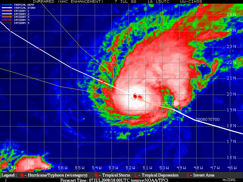
Calling Bertha a 155mph hurricane. She is wrapped tight.
0 likes
-
Stratosphere747
- Category 5
- Posts: 3772
- Joined: Thu Sep 11, 2003 8:34 pm
- Location: Surfside Beach/Freeport Tx
- Contact:
Re: Re:
MiamiensisWx wrote:Stratosphere747 wrote:I'm assuming he means that there will be no true westward movement in the future, ie; stalling/meandering and coming back towards the EC.
Agreed, and since it is already moving slowly and steadily north, the upcoming pattern probably will not result in a sustained WNW/NW movement toward Bermuda prior to moving NNE.
While I lean towards a smooth blending and recurvature, I don't think we are just to the point of being too highly confident.
You've done a fantastic job with evaluating and trying to assess the overall environment ahead of the system and getting a gauge of the future movement, that I'm sure you understand how fluid it still can be.
Don't fully lock yourself into one set scenario yet, and keep your options open from a forecasting standpoint...
0 likes

Re: Hurricane Bertha in Central Atlantic
Mecklenburg wrote:hmm... these waters in the vicinity did spawned major hurricanes like FABIAN, ISABEL, FRANCES, GEORGES etc... however it deprived PHILIPPE back in 2005
Bertha - Early July
Fabian- Late August
Isabel- Early September
Frances- Late August
Georges- Mid September
Not really the same waters. They were much warmer for those four storms.
0 likes
-
srainhoutx

- S2K Supporter

- Posts: 6919
- Age: 68
- Joined: Sun Jan 14, 2007 11:34 am
- Location: Haywood County, NC
- Contact:
Re: Hurricane Bertha in Central Atlantic
KatDaddy wrote:Calling Bertha a 155mph hurricane. She is wrapped tight.
Yep. NOAA recon could varify it tomorrow. Remember folks, wxman57 talked of stalling a couple of days ago.
Last edited by srainhoutx on Mon Jul 07, 2008 7:08 pm, edited 1 time in total.
0 likes

Re: Hurricane Bertha in Central Atlantic
I think Bertha will probably continue here course NW to North through the night. She seems to be more under the influence of the mean-layer steering flow around the high to the east. Once the ridge starts to build back to the north tomorrow, she may track more westerly again, before she makes the final turn out to sea.
0 likes
-
Stratosphere747
- Category 5
- Posts: 3772
- Joined: Thu Sep 11, 2003 8:34 pm
- Location: Surfside Beach/Freeport Tx
- Contact:
Re: Hurricane Bertha in Central Atlantic
srainhoutx wrote:KatDaddy wrote:Calling Bertha a 155mph hurricane. She is wrapped tight.
Yep. NOAA recon could varify it tomorrow.
I guess a big ? mark applies on both statements...
0 likes
Re: Hurricane Bertha in Central Atlantic
KatDaddy wrote:Calling Bertha a 155mph hurricane. She is wrapped tight.
You know that would be Wilma-like intensification in 27.5C water?
0 likes
-
CrazyC83
- Professional-Met

- Posts: 34315
- Joined: Tue Mar 07, 2006 11:57 pm
- Location: Deep South, for the first time!
Re: Hurricane Bertha in Central Atlantic
RL3AO wrote:KatDaddy wrote:Calling Bertha a 155mph hurricane. She is wrapped tight.
You know that would be Wilma-like intensification in 27.5C water?
For all we know it may not even be as strong as satellite suggests. Wilma was in like 32C water.
0 likes
-
Mecklenburg
Re: Hurricane Bertha in Central Atlantic
could be bertha be that strong now that the shearing winds can no longer penetrate it's center?
0 likes
-
Matt-hurricanewatcher
Re: Hurricane Bertha in Central Atlantic
I'm sure its 110 knots with pressure around 938 millibars. But the eye is getting very very small...So it is hitting its peak very soon.
0 likes
-
HarlequinBoy

- Category 5
- Posts: 1400
- Age: 35
- Joined: Wed Nov 29, 2006 1:57 am
- Location: Memphis
Who is online
Users browsing this forum: No registered users and 10 guests