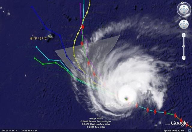
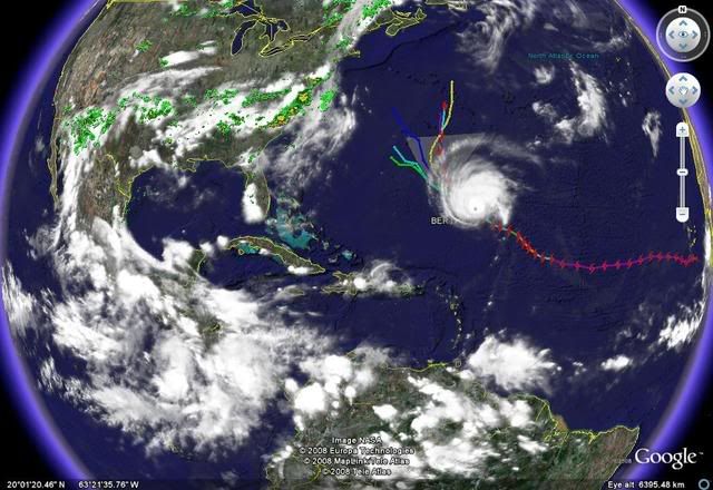
TC Bertha
Moderator: S2k Moderators
-
jaxfladude
- Category 5

- Posts: 1249
- Joined: Wed Aug 24, 2005 9:36 pm
- Location: Jacksonville, Fla
Re: Hurricane Bertha in Central Atlantic
Any chances that Bertha will be the hurricane story of the year(as much chance of Bertha hitting the CONUS) ....one can only hope.....
0 likes
- george_r_1961
- S2K Supporter

- Posts: 3171
- Age: 64
- Joined: Sat Oct 12, 2002 9:14 pm
- Location: Carbondale, Pennsylvania
Re: Hurricane Bertha in Central Atlantic
Fact I do agree that the Maritime Provinces need to watch this very carefully. Especially Newfoundland.
Effects to New England should be limited to high surf.
Effects to New England should be limited to high surf.
0 likes
- wxmann_91
- Category 5

- Posts: 8007
- Age: 34
- Joined: Fri Jul 15, 2005 2:49 pm
- Location: Southern California
- Contact:
Re: Re:
fact789 wrote:Derek Ortt wrote:earlier... you would have far more false alarms... which leads to the "Keys Culture"
As todays people becomes more prepared, smarter and aware of their surroundings, and as the NHC becomes better at forecasting, I think that more people will understand the possibility of being a little off, and the NHC should allow for more warning. JMO.
People will never understand the possibility of being off. It's part of the field but the public demands it to be right. If it isn't, it causes inconveniences and annoyances and that gets people's nerves. It's the cry wolf syndrome.
0 likes
-
weatherguru18
Re: Hurricane Bertha in Central Atlantic
Anybody else notice a pretty good wobble to the left or is it just me?
http://www.goes.noaa.gov/HURRLOOPS/huirloop.html
http://www.goes.noaa.gov/HURRLOOPS/huirloop.html
0 likes
- Weatherfreak14
- Category 5

- Posts: 1381
- Joined: Sat Sep 24, 2005 3:40 pm
- Location: Beaufort, SC
- Contact:
Re: Hurricane Bertha in Central Atlantic
weatherguru18 wrote:Anybody else notice a pretty good wobble to the left or is it just me?
http://www.goes.noaa.gov/HURRLOOPS/huirloop.html
I think it just the eye woobling not the movement.. But you could be right got to wiat for more new frames.
0 likes
- HURAKAN
- Professional-Met

- Posts: 46084
- Age: 39
- Joined: Thu May 20, 2004 4:34 pm
- Location: Key West, FL
- Contact:
Re: Hurricane Bertha in Central Atlantic
weatherguru18 wrote:Anybody else notice a pretty good wobble to the left or is it just me?
http://www.goes.noaa.gov/HURRLOOPS/huirloop.html
It's generally moving NW. It wobbles north and west, but in general, the track is about NW.
0 likes
-
weatherguru18
Re: Hurricane Bertha in Central Atlantic
I know it's a wobble. I don't expect a trend here. Just curious if I was seeing correctly and it appears that I have. Keep in mind though that wobbles can be crutial in future placement of the center. A 25 or 50 mile jog either way could mean 150 mile difference in placement in a couple days. Being that it's a wobble to the left, Bermuda needs to be extra cautious. It's like shooting a gun. Small movement of the gun means 10's of feet down range.
A wobble to the right is probably what spared Houston during Hurricane Rita.
A wobble to the right is probably what spared Houston during Hurricane Rita.
0 likes
- AJC3
- Admin

- Posts: 4153
- Age: 62
- Joined: Tue Aug 31, 2004 7:04 pm
- Location: Ballston Spa, New York
- Contact:
Re: Hurricane Bertha in Central Atlantic
weatherguru18 wrote: A wobble to the right is probably what spared Houston during Hurricane Rita.
Nah. Rita's track was gradually bending away from the Houston/Galveston area....much moreso than any trochoidal wobble would be responsible for.
0 likes
-
Stratosphere747
- Category 5

- Posts: 3772
- Joined: Thu Sep 11, 2003 8:34 pm
- Location: Surfside Beach/Freeport Tx
- Contact:
Re: Hurricane Bertha in Central Atlantic
weatherguru18 wrote:
A wobble to the right is probably what spared Houston during Hurricane Rita.
Negative....
0 likes
- cycloneye
- Admin

- Posts: 149291
- Age: 69
- Joined: Thu Oct 10, 2002 10:54 am
- Location: San Juan, Puerto Rico
Re: Hurricane Bertha in Central Atlantic
UW - CIMSS
ADVANCED DVORAK TECHNIQUE
ADT-Version 7.2.3
Tropical Cyclone Intensity Algorithm
----- Current Analysis -----
Date : 10 JUL 2008 Time : 011500 UTC
Lat : 25:14:47 N Lon : 58:44:52 W
CI# /Pressure/ Vmax
5.4 / 961.7mb/ 99.6kt
Final T# Adj T# Raw T#
(3hr avg)
4.6 4.6 4.6
Latitude bias adjustment to MSLP : -0.3mb
Estimated radius of max. wind based on IR : 19 km
Center Temp : +4.6C Cloud Region Temp : -49.0C
Scene Type : EYE
Positioning Method : RING/SPIRAL COMBINATION
Ocean Basin : ATLANTIC
Dvorak CI > MSLP Conversion Used : ATLANTIC
Tno/CI Rules : Constraint Limits : NO LIMIT
Weakening Flag : ON
Rapid Dissipation Flag : FLAG
0 likes
- brunota2003
- S2K Supporter

- Posts: 9476
- Age: 35
- Joined: Sat Jul 30, 2005 9:56 pm
- Location: Stanton, KY...formerly Havelock, NC
- Contact:
"Weakening Flag : ON"
Rut Ro Raggy! I think someone is about to fall apart again, if not slowly fading away already.
Edit:
It was also flagged for the potential of rapid dissipation.
"Rapid Dissipation Flag : FLAG"
Rut Ro Raggy! I think someone is about to fall apart again, if not slowly fading away already.
Edit:
It was also flagged for the potential of rapid dissipation.
"Rapid Dissipation Flag : FLAG"
Last edited by brunota2003 on Wed Jul 09, 2008 9:31 pm, edited 1 time in total.
0 likes
-
JonathanBelles
- Professional-Met

- Posts: 11430
- Age: 35
- Joined: Sat Dec 24, 2005 9:00 pm
- Location: School: Florida State University (Tallahassee, FL) Home: St. Petersburg, Florida
- Contact:
IT IS STILL TOO EARLY TO DETERMINE THE EXTENT TO WHICH BERTHA COULD
IMPACT BERMUDA. INTERESTS ON THAT ISLAND SHOULD CLOSELY MONITOR
THE PROGRESS OF BERTHA DURING THE NEXT SEVERAL DAYS.
This is now right at the top of the forecast advisory and public advisory. I also notice they're now using the word "extent".
IMPACT BERMUDA. INTERESTS ON THAT ISLAND SHOULD CLOSELY MONITOR
THE PROGRESS OF BERTHA DURING THE NEXT SEVERAL DAYS.
This is now right at the top of the forecast advisory and public advisory. I also notice they're now using the word "extent".
0 likes
- Weatherfreak14
- Category 5

- Posts: 1381
- Joined: Sat Sep 24, 2005 3:40 pm
- Location: Beaufort, SC
- Contact:
Re:
brunota2003 wrote:"Weakening Flag : ON"
Rut Ro Raggy! I think someone is about to fall apart again, if not slowly fading away already.
Any fall in the CI number will cause the weakening flag to trigger. It's not a good judge.
Edit:
It was also flagged for the potential of rapid dissipation.
"Rapid Dissipation Flag : FLAG"
Uhm, shouldn't that say "ON" if it was on, rather than "FLAG"?
0 likes
Who is online
Users browsing this forum: No registered users and 11 guests


