Possible development east of Lesser Antilles,model runs here

This is the general tropical discussion area. Anyone can take their shot at predicting a storms path.

Moderator: S2k Moderators

Forum rules

The posts in this forum are NOT official forecasts and should not be used as such. They are just the opinion of the poster and may or may not be backed by sound meteorological data. They are NOT endorsed by any professional institution or STORM2K. For official information, please refer to products from the National Hurricane Center and National Weather Service.

Help Support Storm2K
Message
Author
User avatar
Meso
Category 5
Category 5
Posts: 1609
Age: 38
Joined: Mon Aug 09, 2004 12:14 pm
Location: South Africa
Contact:

#61 Postby Meso » Thu Jul 10, 2008 2:15 am

Image

why hello there.
0 likes   

Scorpion

#62 Postby Scorpion » Thu Jul 10, 2008 2:25 am

Oh, very interesting. The GFS kills it off for some reason though. Still, this looks like something to watch.
0 likes   

User avatar
Vortex
S2K Supporter
S2K Supporter
Posts: 4644
Age: 53
Joined: Fri Aug 01, 2003 9:34 pm
Location: Hilton Head, SC

#63 Postby Vortex » Thu Jul 10, 2008 4:43 am

The 00z GFS continues to support the idea of a storm passing over/near the leewards in 7-10 days from the formation of low pressure SW of the Cape Verde islands over the next few days.

00Z GFS Loop

http://www.nco.ncep.noaa.gov/pmb/nwprod ... loop.shtml


The 00Z ECMWF also supports this idea bringing a cyclone into the islands in about 8-10 days.

00Z ECM Loop

http://www.ecmwf.int/products/forecasts ... 00!!!step/
0 likes   

User avatar
HURAKAN
Professional-Met
Professional-Met
Posts: 46086
Age: 38
Joined: Thu May 20, 2004 4:34 pm
Location: Key West, FL
Contact:

#64 Postby HURAKAN » Thu Jul 10, 2008 5:25 am

Image
0 likes   

User avatar
KWT
Category 5
Category 5
Posts: 31415
Joined: Tue Aug 17, 2004 11:02 am
Location: UK!!!

#65 Postby KWT » Thu Jul 10, 2008 5:55 am

Hmmm the plot deepens with the ECM also showing of a tropical cyclone from the wave coming off Africa. This may need to be watched as SST's are high enough and the SAL doesn't look all that problematic either and we've seen Bertha form very far east so this could be interesting further west.

mind you ECM doesn't do anytthing with it till about 144hrs so we've got a while to watch it.
0 likes   

User avatar
Gustywind
Category 5
Category 5
Posts: 12334
Joined: Mon Sep 03, 2007 7:29 am
Location: Baie-Mahault, GUADELOUPE

#66 Postby Gustywind » Thu Jul 10, 2008 7:01 am

000
FXCA62 TJSJ 100941
AFDSJU

AREA FORECAST DISCUSSION
NATIONAL WEATHER SERVICE SAN JUAN PR
541 AM AST THU JUL 10 2008


LATEST GFS MODEL GUIDANCE CONTINUES TO SUGGESTS THAT AN ACTIVE TROPICAL WAVE WILL APPROACH TO THE LOCAL ISLANDS NEXT TUESDAY...PRODUCING A GENERAL INCREASE IN SHOWER ACTIVITY ACROSS THE REGION. LOOKING WELL AHEAD...THE MODELGUIDANCES ALSO SUGGESTS THAT A WELL DEFINED LOW PRESSURE SYSTEM WILL MOVE VERY CLOSE TO THE FORECAST AREA BY JULY 20-21. APPARENTLY THE TROPIC WILL CONTINUE VERY ACTIVE. STAY TUNED. :?: :roll:
0 likes   

User avatar
CourierPR
Category 5
Category 5
Posts: 1335
Age: 71
Joined: Tue Aug 31, 2004 7:53 pm
Location: Pompano Beach, Florida

Re: GFS spawns New Low off Africa

#67 Postby CourierPR » Thu Jul 10, 2008 7:33 am

It's post time and the horses are at the gate. The plot thickens.
0 likes   

tolakram
Admin
Admin
Posts: 20017
Age: 62
Joined: Sun Aug 27, 2006 8:23 pm
Location: Florence, KY (name is Mark)

Re: GFS spawns New Low off Africa

#68 Postby tolakram » Thu Jul 10, 2008 7:51 am

I'm going to Gulf Shores AL July 17th so no funny business from anything till I'm done. :)
0 likes   

Ed Mahmoud

Re: GFS spawns New Low off Africa

#69 Postby Ed Mahmoud » Thu Jul 10, 2008 7:55 am

tolakram wrote:I'm going to Gulf Shores AL July 17th so no funny business from anything till I'm done. :)


How many days? Even if the Euro is correct, this system couldn't be in the Gulf before about the 23rd.
0 likes   

Stormcenter
S2K Supporter
S2K Supporter
Posts: 6684
Joined: Wed Sep 03, 2003 11:27 am
Location: Houston, TX

Re: GFS spawns New Low off Africa

#70 Postby Stormcenter » Thu Jul 10, 2008 8:14 am

I hate burst any bubbles but as they say "I'll believe it when I see it". I'm waiting for the real meat and potatoes of the season to start between August 15th and September 15th.
0 likes   

chadtm80

Re: GFS spawns New Low off Africa

#71 Postby chadtm80 » Thu Jul 10, 2008 8:36 am

Image
0 likes   

User avatar
KWT
Category 5
Category 5
Posts: 31415
Joined: Tue Aug 17, 2004 11:02 am
Location: UK!!!

#72 Postby KWT » Thu Jul 10, 2008 8:37 am

The problem is stormenter w ehave already seen a storm develop from a Cape Verde wave so clearly the Atlantic can support these sorts of waves from now onwards. Granted thats not to say this will form at all but we do need to watch every wave from now on and not just in the meat of the season.
0 likes   

jlauderdal
S2K Supporter
S2K Supporter
Posts: 7189
Joined: Wed May 19, 2004 5:46 am
Location: NE Fort Lauderdale
Contact:

Re: GFS spawns New Low off Africa

#73 Postby jlauderdal » Thu Jul 10, 2008 8:54 am

Stormcenter wrote:I hate burst any bubbles but as they say "I'll believe it when I see it". I'm waiting for the real meat and potatoes of the season to start between August 15th and September 15th.


the good news for you is that the texas threat will be greatly diminished by the time the meat and potatos starts
0 likes   

Ed Mahmoud

Re: GFS spawns New Low off Africa

#74 Postby Ed Mahmoud » Thu Jul 10, 2008 9:02 am

jlauderdal wrote:
Stormcenter wrote:I hate burst any bubbles but as they say "I'll believe it when I see it". I'm waiting for the real meat and potatoes of the season to start between August 15th and September 15th.


the good news for you is that the texas threat will be greatly diminished by the time the meat and potatos starts


Been my unofficial opinion this is a Florida and Carolinas season as far as US landfalls go.


Hurricane Allen being a notable exception, but few CV storms make it all the way to Texas.
0 likes   

User avatar
CourierPR
Category 5
Category 5
Posts: 1335
Age: 71
Joined: Tue Aug 31, 2004 7:53 pm
Location: Pompano Beach, Florida

Re: GFS spawns New Low off Africa

#75 Postby CourierPR » Thu Jul 10, 2008 9:58 am

Stormcenter wrote:I hate burst any bubbles but as they say "I'll believe it when I see it". I'm waiting for the real meat and potatoes of the season to start between August 15th and September 15th.

You'd better belly up to the table now because you might miss some good food.
0 likes   

Stormcenter
S2K Supporter
S2K Supporter
Posts: 6684
Joined: Wed Sep 03, 2003 11:27 am
Location: Houston, TX

Re: GFS spawns New Low off Africa

#76 Postby Stormcenter » Thu Jul 10, 2008 10:02 am

You guys all make good points.
0 likes   

dwg71
Category 5
Category 5
Posts: 2349
Joined: Wed Jun 08, 2005 4:34 pm

#77 Postby dwg71 » Thu Jul 10, 2008 10:23 am

All storms are mutually exclusive, conditions are constantly changing. Just because Bertha trekked early, doesnt mean conditions could not turn hostile and make formation much more difficult.
0 likes   

User avatar
CourierPR
Category 5
Category 5
Posts: 1335
Age: 71
Joined: Tue Aug 31, 2004 7:53 pm
Location: Pompano Beach, Florida

Re:

#78 Postby CourierPR » Thu Jul 10, 2008 10:40 am

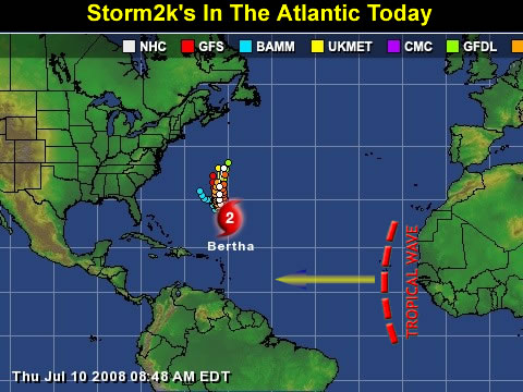
dwg71 wrote:All storms are mutually exclusive, conditions are constantly changing. Just because Bertha trekked early, doesnt mean conditions could not turn hostile and make formation much more difficult.

That's true, but as we draw closer to the heart of the season I expect that a generally favorable setup will occur. Some models hint at something brewing in the days ahead. If that happens, I think we will see a quite active season.
0 likes   

User avatar
Vortex
S2K Supporter
S2K Supporter
Posts: 4644
Age: 53
Joined: Fri Aug 01, 2003 9:34 pm
Location: Hilton Head, SC

Re: GFS spawns New Low off Africa

#79 Postby Vortex » Thu Jul 10, 2008 10:52 am

jlauderdal wrote:
Stormcenter wrote:I hate burst any bubbles but as they say "I'll believe it when I see it". I'm waiting for the real meat and potatoes of the season to start between August 15th and September 15th.


the good news for you is that the texas threat will be greatly diminished by the time the meat and potatos starts

:lol:
0 likes   

User avatar
Extremeweatherguy
Category 5
Category 5
Posts: 11095
Joined: Mon Oct 10, 2005 8:13 pm
Location: Florida

#80 Postby Extremeweatherguy » Thu Jul 10, 2008 11:17 am

The 12z GFS forms a low pressure center out in the central Atlantic by hour 90..

Surface = http://www.nco.ncep.noaa.gov/pmb/nwprod ... n_090s.gif
850mb vort = http://www.nco.ncep.noaa.gov/pmb/nwprod ... v_090s.gif

And then strengthens it as it moves west (hour 114)..

Surface = http://www.nco.ncep.noaa.gov/pmb/nwprod ... n_114s.gif
850mb vort = http://www.nco.ncep.noaa.gov/pmb/nwprod ... v_114s.gif

By hour 138, the low is still holding steady and moving W/WNW..

Surface = http://www.nco.ncep.noaa.gov/pmb/nwprod ... n_138s.gif
850mb vort = http://www.nco.ncep.noaa.gov/pmb/nwprod ... v_138s.gif

low is still there at hour 168 (7 days from now)..

Surface = http://www.nco.ncep.noaa.gov/pmb/nwprod ... n_168s.gif
850mb vort = http://www.nco.ncep.noaa.gov/pmb/nwprod ... v_168s.gif

Also (a bit off topic) - Check out Bertha a week from now!!! According to the GFS it will have grown tremendously in size and it will still be very intense and stalled right near Bermuda.

In the longer range, the lower resolution of the 180 hour+ GFS loses the actual low center, but it still depicts the "system" as a strong wave impacting the northern islands in 228 hours...

Surface = http://www.nco.ncep.noaa.gov/pmb/nwprod ... n_228s.gif
850mb vort = http://www.nco.ncep.noaa.gov/pmb/nwprod ... v_228s.gif

By 288 hours, the "system" (be it a very strong wave or a tropical cyclone) is located in the central Bahamas...

Surface = http://www.nco.ncep.noaa.gov/pmb/nwprod ... n_288s.gif
850mb vort = http://www.nco.ncep.noaa.gov/pmb/nwprod ... v_288s.gif

By hour 324, the state of Florida is receiving the largest impact from this "system"...

Surface = http://www.nco.ncep.noaa.gov/pmb/nwprod ... n_324s.gif
850mb vort = http://www.nco.ncep.noaa.gov/pmb/nwprod ... v_324s.gif
Last edited by Extremeweatherguy on Thu Jul 10, 2008 11:44 am, edited 2 times in total.
0 likes   


Return to “Talkin' Tropics”

Who is online

Users browsing this forum: LarryWx, Ulf and 24 guests