
TC Bertha
Moderator: S2k Moderators
-
Category 5

- Category 5

- Posts: 10074
- Age: 35
- Joined: Sun Feb 11, 2007 10:00 pm
- Location: New Brunswick, NJ
- Contact:
Re: Hurricane Bertha in Western Atlantic
Looks like an EWRC going on. That might be bad news for Bermuda.
0 likes

-
JonathanBelles
- Professional-Met

- Posts: 11430
- Age: 35
- Joined: Sat Dec 24, 2005 9:00 pm
- Location: School: Florida State University (Tallahassee, FL) Home: St. Petersburg, Florida
- Contact:
-
storms in NC

- S2K Supporter

- Posts: 2338
- Joined: Thu Jul 28, 2005 2:58 pm
- Location: Wallace,NC 40 miles NE of Wilm
- Contact:
I was thinking. Has there ever been a storm that came from the east and hit the east coast? I guess I will have to do some looking up to do.
[IN A MAJOR SHIFT FROM PREVIOUS RUNS...NONE OF THE
DYNAMICAL MODELS SHOW BERTHA REACHING 40N IN 5 DAYS]
If this comes about I don't think it will become a threat to Canada any thime soon. If any
[IN A MAJOR SHIFT FROM PREVIOUS RUNS...NONE OF THE
DYNAMICAL MODELS SHOW BERTHA REACHING 40N IN 5 DAYS]
If this comes about I don't think it will become a threat to Canada any thime soon. If any
0 likes


-
MiamiensisWx
Re: Hurricane Bertha in Western Atlantic
The following post is NOT an official prognosis.
Currently, a significant pattern change has developed in the Pacific, and the effects are permeating the downstream pattern to the east. The strong upper level Southwest CONUS ridging has weakened, coinciding with a deepening longwave H5 trough over western Canada and British Columbia. In addition, the upper low over the Aleutians has deepened. The previously dominant west based -NAO over Greenland has weakened with the northward shift of the upper level block. A strong H5 vort max has replaced the upper level block over central and southern Greenland. Consequently, the upper air pattern over the CONUS has transitioned to a fast, progressive zonal flow. The H5 pattern reflects it, while a strong northern stream is evident at 200 mb. The pattern change over the CONUS will exert a significant effect on the evolution of Bertha's movement and track over the next several days. I originally did not anticipate the effects of the MJO as well, so I originally expected Bertha to recurve east of Bermuda (per my last analysis) in advance of the current upper level trough. However, I did harbor some contrary thoughts, many of which were correct; consequently, my original prognosis has changed, and I believe model trends are catching on to a slower track and stalling Bertha further west near Bermuda.
One factor for the shortening of wavelengths is the divergence induced by the arrival of the Madden-Julian Oscillation (MJO) across the eastern Pacific and the entire Atlantic basin. The upward pulse and strengthening equatorial anomalies is aiding increased convection over the eastern tropical Pacific, and it is partially contributing to the shorter wavelengths and developing progressive zonal flow over the CONUS. As evidenced on water vapor imagery, the upper level shortwave trough is leaving Bertha trapped by a strengthening upper level ridge as an upper low to the east induces amplification. This will likely result in a stall very close to Bermuda over the next few days. Bertha's long term NW movement has been consistently slightly west of the model "cluster", and with the increasing size of Bertha's wind radii, a TS or Hurricane Watch will likely be warranted. Even if Bertha passed further east, the large size would have still resulted in a large fetch with high waves, and TS winds would have likely occurred on Bermuda. I think it was premature for some people to completely dismiss the risk from a "fringe" impact to Bermuda. Additionally, they have remained within or near the three day and five day cones over the past several days. Residents in southwest FL prior to Charley now realize that it is prudent to heed the CONE, especially in uncertain short to medium term situations.
In regards to the intensity, Category 1 tropical cyclones can experience eyewall replacement cycles. I have observed it in the past, and Bertha has clearly demonstrated it throughout today. Mid level dry air likely did not impact the TC significantly, as evidenced by the lack of characteristic arc clouds, which are often seen as an indicator of dry air/subsidence in the boundary layer. This has been a classical ERC, and it is still ongoing. Bertha is exhibiting a well defined moat signature, where sinking subsidence from adjacent convection induces the formation of a larger eye, while the outer concentric eyewall begins to contract. With excellent diffluence in the vicinity, upper level divergence from an adjacent upper low, and greater oceanic heat content, Bertha will likely re-intensify within the 24 hours as the outer eyewall contracts. Later, as Bertha passes north of the upper low to the SW, it could encounter stronger shear along the southern semicircle from the upper low, which would potentially reduce inflow for a brief period. However, the effects on Bertha's intensity will likely be more marginal when compared to thermodynamics over the next few days. Overall, I believe Bertha may eventually approach or re-attain Category 2 intensity over the next few days as it stalls near Bermuda. It is highly unlikely that it will become stronger than ~85 kt, as there will be some limiting factors such as slightly higher upper level shear, but it is recommended that residents should always remain prepared for winds higher than progged.
In regards to the track, models have been biased to the east over the past few days. Bertha's predominant NW movement has been hedging the western extent of the model "cluster". Recently, in response to better ingestion of data regarding the synoptics, some models have shifted west. This realistic trend is also reflected in the recent west shifts of the NHC's three day and five day cones as well. Bertha will probably stall very close to the island within the next few days, and this is indicated by the operational GFS, Euro, and GFS ensembles. It is possible that the center will pass quite close to the island. This will result in a prolonged threat for high waves and strong winds, especially with the larger wind radii. However, Bermuda features very staunch and stringent construction methods, so they are definitely "built to survive" the effects of tropical cyclones' winds. Regardless, erosion will be a big threat for structures.
In a nutshell, Bermuda should "batten down the hatches" for the threat of Bertha.
0 likes
-
jaxfladude
- Category 5
- Posts: 1249
- Joined: Wed Aug 24, 2005 9:36 pm
- Location: Jacksonville, Fla
Re: Re:
cycloneye wrote:HURAKAN wrote:It seems we have Bertha for at least a week. This will most likely allow Bertha to continue breaking new ground in the record books of S2K in the number of pages per thread.
This thread is closing in on 4th place on the list of most pages as Frances had 187.
Well, just another reason to have "Bertha" retired next year.
But is it a record for this part of the season before July 31st?
0 likes
-
HURAKAN

- Professional-Met
- Posts: 46086
- Age: 38
- Joined: Thu May 20, 2004 4:34 pm
- Location: Key West, FL
- Contact:
Re: Re:
jaxfladude wrote:cycloneye wrote:HURAKAN wrote:It seems we have Bertha for at least a week. This will most likely allow Bertha to continue breaking new ground in the record books of S2K in the number of pages per thread.
This thread is closing in on 4th place on the list of most pages as Frances had 187.
Well, just another reason to have "Bertha" retired next year.
But is it a record for this part of the season before July 31st?
So far this Bertha doesn't deserve to be retired.
0 likes

Bertha is looking really impressive again, I doubt EWRC is happening right now given the eye is so well established still but we will see very soon what will happen.
Also note the small shifts to the west still, looks like this is going to get close enough to at least give TS winds to Bermuda I think.
Also note the small shifts to the west still, looks like this is going to get close enough to at least give TS winds to Bermuda I think.
0 likes
-
jaxfladude
- Category 5
- Posts: 1249
- Joined: Wed Aug 24, 2005 9:36 pm
- Location: Jacksonville, Fla
Re: Re:
Just kidding about the retirement thing....  ....
....
It seems to come up with every storm for whatever reason....
It seems to come up with every storm for whatever reason....
0 likes
-
weatherguru18
Re: Hurricane Bertha in Western Atlantic
Yup, Bertha's structure has definitely improved over the last several hours. Bertha appears to be losing her cataracts again. That ull may be helping to vent the system. Still a bit of dry air on the sw side of the eyewall.
0 likes
-
cycloneye

- Admin

- Posts: 148578
- Age: 69
- Joined: Thu Oct 10, 2002 10:54 am
- Location: San Juan, Puerto Rico
Re: Hurricane Bertha in Western Atlantic
ACE for Bertha continues to go up,now 13.915,the season in total is at 14.3:
http://en.wikipedia.org/wiki/2008_Atlan ... ane_season
Code: Select all
Season total
Storm Type ACE (104 kt2)
01L (Arthur) Operational 0.3675
02L (Bertha) Operational 13.915
Total  14.2825
http://en.wikipedia.org/wiki/2008_Atlan ... ane_season
0 likes
-
MiamiensisWx
Re:
KWT wrote:Bertha is looking really impressive again, I doubt EWRC is happening right now given the eye is so well established still but we will see very soon what will happen.
Also note the small shifts to the west still, looks like this is going to get close enough to at least give TS winds to Bermuda I think.

The recent TRMM scan definitely indicates an ongoing ERC. Organization will improve even more as the outer eyewall contracts. Keep in mind that the strongest winds may not be mixing to the surface; in other words, Bertha may "look" stronger than 75 kt, but appearances can be extremely deceiving. Personally, I strongly believe the 75 kt intensity is very close to the actual peak 1-min surface winds, though I suspect intensification will commence very soon. When that trend occurs, winds will likely mix rapidly to the surface, especially as the TC is situated over greater SSTs. This results in more ascent of parcels and an unstable boundary layer will be present.
0 likes
Ah yeah that does look like a EWRC looking at the microwave imagery, interesting to see the eye is still very well defined though!
I take it though its sort of stuck between the cycle as the eye is still well defined but also the outer eyewlal and maot is still clearly there.
Hopefully it peaks for recon!
I take it though its sort of stuck between the cycle as the eye is still well defined but also the outer eyewlal and maot is still clearly there.
Hopefully it peaks for recon!
0 likes
-
cycloneye
- Admin
- Posts: 148578
- Age: 69
- Joined: Thu Oct 10, 2002 10:54 am
- Location: San Juan, Puerto Rico
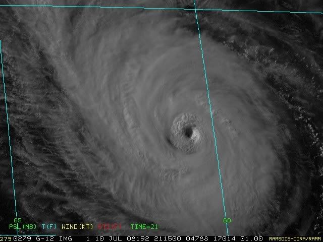
Re: Hurricane Bertha in Western Atlantic
UW - CIMSS
ADVANCED DVORAK TECHNIQUE
ADT-Version 7.2.3
Tropical Cyclone Intensity Algorithm
----- Current Analysis -----
Date : 10 JUL 2008 Time : 211500 UTC
Lat : 27:10:27 N Lon : 60:32:37 W
CI# /Pressure/ Vmax
5.0 / 969.1mb/ 90.0kt
Final T# Adj T# Raw T#
(3hr avg)
5.0 5.0 5.0
Latitude bias adjustment to MSLP : -0.9mb
Estimated radius of max. wind based on IR : 17 km
Center Temp : +7.5C Cloud Region Temp : -50.3C
Scene Type : EYE
Positioning Method : RING/SPIRAL COMBINATION
Ocean Basin : ATLANTIC
Dvorak CI > MSLP Conversion Used : ATLANTIC
Tno/CI Rules : Constraint Limits : NO LIMIT
Weakening Flag : OFF
Rapid Dissipation Flag : OFF
0 likes
Who is online
Users browsing this forum: No registered users and 40 guests