Possible development east of Lesser Antilles,model runs here

This is the general tropical discussion area. Anyone can take their shot at predicting a storms path.

Moderator: S2k Moderators

Forum rules

The posts in this forum are NOT official forecasts and should not be used as such. They are just the opinion of the poster and may or may not be backed by sound meteorological data. They are NOT endorsed by any professional institution or STORM2K. For official information, please refer to products from the National Hurricane Center and National Weather Service.

Help Support Storm2K
Message
Author
Ed Mahmoud

Re: GFS,EURO spawns New Low off Africa

#101 Postby Ed Mahmoud » Thu Jul 10, 2008 4:10 pm

hial2 wrote:
Ed Mahmoud wrote:If one checks out the Euro 500 mb heights, it seems, if the Euro is right, both systems may stay fairly far South. The bigger system appears to bend North in response to a trough moving off the East Coast, but that trough looks like it is moving out on Day 10 and being replaced with a solid looking ridge. May never get to the US, even if the Euro is correct. Of course, a path through Hispaniola, while disasterous for the poor inhabitants of an island with steep slopes, would also mean the possibility that a badly disrupted system would result.


Of course, at 10 days, a potential system could miss Hispaniola on either side, if a system even forms.


But, in my highly unofficial and amateur opinion, any tropical systems coming off Africa and developing in the next week to week and a half may stay South of the US, and be Caribbean and Central American threats. Or they may not.


Way to go out on a limb, Ed..... :D


Pretty bold forecast for an amateur, I know.
0 likes   

User avatar
KWT
Category 5
Category 5
Posts: 31415
Joined: Tue Aug 17, 2004 11:02 am
Location: UK!!!

#102 Postby KWT » Thu Jul 10, 2008 5:00 pm

Looks like the Atlantic is starting to come alive again, Euro has 3 systems at the same time!

Anyway this has got model support and though it doesn't look all that likely that it will form as close to Africa as Bertha there is enough support to need to watch this closely as it reaches the western Atlantic in an area that can support tropical systems. The longer it stays weaker the greater the threat to the Caribbean, if it gets developing quickly then who knows!

As for this season being like 2005, I doubt it BUT a season like 1995 isn't totally out of the question at this very early stage but we will see!
0 likes   

User avatar
Extremeweatherguy
Category 5
Category 5
Posts: 11095
Joined: Mon Oct 10, 2005 8:13 pm
Location: Florida

#103 Postby Extremeweatherguy » Thu Jul 10, 2008 5:05 pm

0 likes   

User avatar
Extremeweatherguy
Category 5
Category 5
Posts: 11095
Joined: Mon Oct 10, 2005 8:13 pm
Location: Florida

#104 Postby Extremeweatherguy » Thu Jul 10, 2008 5:06 pm

0 likes   

User avatar
KWT
Category 5
Category 5
Posts: 31415
Joined: Tue Aug 17, 2004 11:02 am
Location: UK!!!

#105 Postby KWT » Thu Jul 10, 2008 5:29 pm

Yep also moving WNW/NW probably thanks to the weakness present by the very slow moving Bertha, this may provide an exit route for this system as well but high is building as well behind it which should send it westwards. IF it forms should be more of a threat to the Caribbean/US then Bertha ever was IMO.
0 likes   

User avatar
KWT
Category 5
Category 5
Posts: 31415
Joined: Tue Aug 17, 2004 11:02 am
Location: UK!!!

#106 Postby KWT » Thu Jul 10, 2008 5:53 pm

Like Bertha all over again:

http://www.nco.ncep.noaa.gov/pmb/nwprod ... n_288s.gif

Tracks through the weakness that was opened up by Bertha, long way east of the 12z run as you'd expect at that distance out.
0 likes   

HURRICANELONNY
Category 5
Category 5
Posts: 1383
Joined: Wed May 07, 2003 6:48 am
Location: HOLLYWOOD.FL

#107 Postby HURRICANELONNY » Thu Jul 10, 2008 6:21 pm

GEE. 288 HRS. That will come true :lol:
0 likes   

User avatar
cycloneye
Admin
Admin
Posts: 145839
Age: 69
Joined: Thu Oct 10, 2002 10:54 am
Location: San Juan, Puerto Rico

Re: GFS,EURO spawns New Low off Africa

#108 Postby cycloneye » Thu Jul 10, 2008 6:28 pm

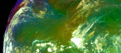
Will this cloud mass emerging Africa tonight be the one the models develop?

Image
0 likes   

User avatar
HURAKAN
Professional-Met
Professional-Met
Posts: 46086
Age: 38
Joined: Thu May 20, 2004 4:34 pm
Location: Key West, FL
Contact:

#109 Postby HURAKAN » Thu Jul 10, 2008 6:31 pm

Luis, that's what we have been discussing in the thread of tropical waves. As with all tropical waves, it's wait and see.
0 likes   

Cryomaniac
Category 5
Category 5
Posts: 1289
Joined: Tue Aug 15, 2006 2:26 pm
Location: Newark, Nottinghamshire, UK
Contact:

Re: GFS,EURO spawns New Low off Africa

#110 Postby Cryomaniac » Thu Jul 10, 2008 6:35 pm

MiamiensisWx wrote:That is absolutely unattainable for 2008 (and the vast majority of Atlantic seasons).


Nothing is impossible.

Activity in 2005 commenced much earlier than 2008.


First storm in '05 = June 8th, '08 = May 31st.

Please cite for the source for your bold statements.


Maybe the post needed a disclaimer, but why should anyone need a source?
0 likes   

MiamiensisWx

Possible development off W Africa during next several days

#111 Postby MiamiensisWx » Thu Jul 10, 2008 7:16 pm

I noticed the other thread, but since it was geared toward multiple systems (instead of the current wave axis that will enter the Atlantic overnight), I'll start a thread dedicated solely to this system.

The operational GFS and Euro are certainly aggressive in regards to Cape Verde cyclogenesis occurring over the next 5-7 days and beyond. It should be noted that the operational GFS and other models often exhibit a well known bias to develop multiple spurious surface lows across the Atlantic basin during the MJO's current presence in the region. Therefore, I doubt the "extreme" solutions depicted and well advertised by the Euro and others in the medium to long term will verify with a series of tropical cyclones crossing the MDR and moving into the Caribbean region. That's exceptionally unrealistic, though I do agree that a more conducive pattern for cyclogenesis is setting up across the basin.

Regardless, I would monitor the wave axis that is currently over the interior of western Africa and will enter the Atlantic overnight and tomorrow. Satellite data suggests that a low pressure area may be associated with the wave axis, and capping from the Saharan Air Layer is minimal to the west and north of the system. In fact, CIMSS analysis indicates the SAL is a much less significant issue than it was with the wave that eventually developed to Bertha. Low level vorticity at 850 mb is also substantive in the immediate vicinity offshore. Shear is minimal across the eastern tropical Atlantic within the MDR, and several models suggest the trend will continue over the next several days with a weaker Azores ridge in place. In addition, as I and others mentioned, the operational GFS and Euro have been suggesting and indicating a more active pattern developing across the basin over the next few weeks. The GFS does develop a surface low ~48 hours out from this current wave that is exiting the coastline. The next ~24 hours of persistence are the key. If convection develops and sustains itself, this current wave may very likely become a player for possible development over the next several days.

As an aside, with the shortening of wavelengths and zonal flow across the CONUS (partially because of the MJO induced stronger equatorial anomalies/divergence), a more favorable Atlantic basin environment seems very plausible.
0 likes   

MiamiensisWx

Re: Possible development off W Africa during next several days

#112 Postby MiamiensisWx » Thu Jul 10, 2008 7:19 pm

Nice curvature and mid level rotation is evident just west of the wave axis:

http://oiswww.eumetsat.org/IPPS/html/DerivedProducts/MSG2/MPE/WESTERNAFRICA/index.htm

SSTA remain above average across the MDR as well.
0 likes   

User avatar
Blown Away
S2K Supporter
S2K Supporter
Posts: 10159
Joined: Wed May 26, 2004 6:17 am

Re: Possible development off W Africa during next several days

#113 Postby Blown Away » Thu Jul 10, 2008 7:20 pm

Great, can you post a map and circle the exact area you are referring to. Thanks.
0 likes   

User avatar
HURAKAN
Professional-Met
Professional-Met
Posts: 46086
Age: 38
Joined: Thu May 20, 2004 4:34 pm
Location: Key West, FL
Contact:

#114 Postby HURAKAN » Thu Jul 10, 2008 7:21 pm

Image

Image

Convection declining as expected.
0 likes   

MiamiensisWx

#115 Postby MiamiensisWx » Thu Jul 10, 2008 7:22 pm

Image

Here ya go!

Keep in mind that the wave axis (vertical red line) is still just inland from the coast. It should emerge overnight and tomorrow.
0 likes   

User avatar
cycloneye
Admin
Admin
Posts: 145839
Age: 69
Joined: Thu Oct 10, 2002 10:54 am
Location: San Juan, Puerto Rico

Re: Possible development off W Africa during next several days

#116 Postby cycloneye » Thu Jul 10, 2008 7:25 pm

Image
0 likes   

MiamiensisWx

#117 Postby MiamiensisWx » Thu Jul 10, 2008 7:27 pm

The operational GFS and some ensembles has been very consistent with tropical cyclogenesis via this wave axis west of Africa around ~48 hours out. The model could be "picking up" on development again, as witnessed with Bertha and Dean at even longer ranges. This one is within the short term, and it is already entering the scene over far western Africa. Additionally, conditions seem more favorable than those that Bertha faced. Overall, I see possibilities, and I'm typically very conservative.
0 likes   

User avatar
Blown Away
S2K Supporter
S2K Supporter
Posts: 10159
Joined: Wed May 26, 2004 6:17 am

Re: Possible development off W Africa during next several days

#118 Postby Blown Away » Thu Jul 10, 2008 7:36 pm

TY, that's what I thought. It's gets confusing when people are talking about multiple areas under the same thread.
0 likes   

User avatar
boca
Category 5
Category 5
Posts: 6369
Age: 60
Joined: Mon Dec 15, 2003 8:49 am
Location: Boca Raton,FL

Re: Possible development off W Africa during next several days

#119 Postby boca » Thu Jul 10, 2008 8:11 pm

I read in Bertha discussion that the storm will not get north of 40n in the five day period.Will that create a weakness simular to Bertha's path for this new low if it develops off Africa or will it get to the islands?
0 likes   

MiamiensisWx

Re: Possible development off W Africa during next several days

#120 Postby MiamiensisWx » Thu Jul 10, 2008 8:14 pm

boca wrote:I read in Bertha discussion that the storm will not get north of 40n in the five day period.Will that create a weakness simular to Bertha's path for this new low if it develops off Africa or will it get to the islands?

Firstly, we need to wait for any development to occur, but several models and my analysis of the synoptics suggest a more southerly track than Bertha is possible if cyclogenesis takes place.

Note that Bertha is expected to stall because of a building upper level ridge in the vicinity. A strong low level ridge is likely as well, which may induce a more "suppressed" track to the south with this system.
0 likes   


Return to “Talkin' Tropics”

Who is online

Users browsing this forum: Google [Bot] and 25 guests