
TC Bertha
Moderator: S2k Moderators
-
HURAKAN

- Professional-Met

- Posts: 46084
- Age: 39
- Joined: Thu May 20, 2004 4:34 pm
- Location: Key West, FL
- Contact:
Re: Re:
AJC3 wrote:Sandy, if that's from 1974, then it's the wrong Carmen (although, interestingly enough, it appears from that radar image that 1974's Carmen may have had a concentric double eye structure!)
I was looking for Hurricane Carmen!!!
0 likes

The final end result of the size of the eye won't be that large, it will be a bit smaller but not much smaller. Every time it's been like this with mature TC's. I don't usually see category 1 hurricanes go through ERC's but the behavior of this Bertha is like a powerful major hurricane without deep convection.
0 likes
Re: Hurricane Bertha in Western Atlantic
I believe the bolded statement is false.
The Pacific has entirely different conditions than the Atlantic that spurs more sustained large-eyed typhoons. I could be wrong but I wouldn't be putting too much stock in a north-heading Atlantic hurricane in early July developing a large sustained eye. My opinion is it is partially dry air banding and a structurally decaying hurricane. But who knows, Bertha's already rebounded twice. But remember the category and location in relation to early July Atlantic conditions.
I agree Bertha was an odd warm-top hurricane for its strength.
Last edited by Sanibel on Thu Jul 10, 2008 10:32 pm, edited 3 times in total.
0 likes
-
cycloneye

- Admin

- Posts: 149298
- Age: 69
- Joined: Thu Oct 10, 2002 10:54 am
- Location: San Juan, Puerto Rico
Re: Hurricane Bertha in Western Atlantic
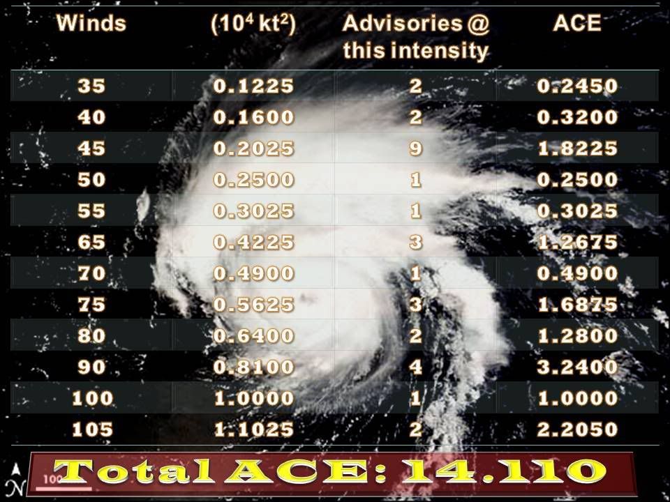
Those who are with the ACE tables,what are the new numbers for Bertha?
0 likes

Re: Hurricane Bertha in Western Atlantic
Still - this IR image is pretty sick too - awesome ERC

0 likes
-
HURAKAN
- Professional-Met
- Posts: 46084
- Age: 39
- Joined: Thu May 20, 2004 4:34 pm
- Location: Key West, FL
- Contact:
Re: Hurricane Bertha in Western Atlantic
cycloneye wrote:Those who are with the ACE tables,what are the new numbers for Bertha?
0 likes

Re: Hurricane Bertha in Western Atlantic
cycloneye wrote:Those who are with the ACE tables,what are the new numbers for Bertha?
Code: Select all
02L.Bertha
Adv.   Date   Time   Maximum Sustained Winds (kt)   ACE (104 kt2)
1   3 July   5 am EDT   30   0
2   3 July   11 am EDT   35   0.1225
3   3 July   5 pm EDT   35   0.1225
4   3 July   11 pm EDT   40   0.1600
5   4 July   5 am EDT   40   0.1600
6   4 July   11 am EDT   45   0.2025
7   4 July   5 pm EDT   45   0.2025
8   4 July   11 pm EDT   45   0.2025
9   5 July   5 am EDT   45   0.2025
10   5 July   11 am EDT   45   0.2025
11   5 July   5 pm EDT   45   0.2025
12   5 July   11 pm EDT   45   0.2025
13   6 July   5 am EDT   45   0.2025
14   6 July   11 am EDT   45   0.2025
15   6 July   5 pm EDT   50   0.2500
16   6 July   11 pm EDT   55   0.3025
17   7 July   5 am EDT   65   0.4225
18   7 July   11 am EDT   80   0.6400
19   7 July   5 pm EDT   100   1.0000
20   7 July   11 pm EDT   105   1.1025
21   8 July   5 am EDT   105   1.1025
22   8 July   11 am EDT   90   0.8100
23   8 July   5 pm EDT   75   0.5625
24   8 July   11 pm EDT   70   0.4900
25   9 July   5 am EDT   65   0.4225
26   9 July   11 am EDT   65   0.4225
27   9 July   5 pm EDT   90   0.8100
28   9 July   11 pm EDT   90   0.8100
29   10 July   5 am EDT   90   0.8100
30   10 July   11 am EDT   80   0.6400
31   10 July   5 pm EDT   75   0.5625
32   10 July   11 pm EDT   75   0.5625
Total               14.1100

Season totalStorm   Type   ACE (104 kt2)
01L (Arthur)   Operational   0.3675
02L (Bertha)   Operational   14.1100
Total      14.4775
0 likes
-
HurricaneRobert
- Category 3

- Posts: 812
- Joined: Fri May 18, 2007 9:31 pm
Re: Hurricane Bertha in Western Atlantic
There's a better picture of Winnie here:
http://ams.allenpress.com/archive/1520- ... -1-137.pdf
It looks like it's almost all eye. The inner eyewall remains and looks like a mini typhoon.
http://ams.allenpress.com/archive/1520- ... -1-137.pdf
It looks like it's almost all eye. The inner eyewall remains and looks like a mini typhoon.
0 likes
-
JonathanBelles
- Professional-Met
- Posts: 11430
- Age: 35
- Joined: Sat Dec 24, 2005 9:00 pm
- Location: School: Florida State University (Tallahassee, FL) Home: St. Petersburg, Florida
- Contact:
-
AJC3

- Admin
- Posts: 4153
- Age: 62
- Joined: Tue Aug 31, 2004 7:04 pm
- Location: Ballston Spa, New York
- Contact:
Re: Hurricane Bertha in Western Atlantic
Sanibel wrote: The Pacific has entirely different conditions than the Atlantic that spurs more sustained large-eyed typhoons.
This is also quite true as well. According to Knaff, et. al. http://www.ssec.wisc.edu/~kossin/articl ... hurr.pdf...
"Composite analysis reveals that the typical annular hurricane exists in a very favorable hurricane environment. Such an environment is characterized by the combination of 1) weak easterly or southeasterly vertical wind shear, 2) easterly flow and relatively cold temperatures at 200 hPa, 3) a narrow range (25.48–28.58C) of SSTs that are nearly constant, and 4) a lack of 200 hPa relative eddy flux convergence due to environmental interactions.. These individual characteristics are quite commonly observed, but the combination of these factors is quite rare occurring 0.8% and 3.0% of the time in the Atlantic and eastern Pacific tropical cyclone basins, respectively.
The paper, which most mets consider to be the seminal reference on annular TC's, goes on to document some additional Atlantic cases such as Luis and Eduoard.
0 likes
-
Category 5

- Category 5

- Posts: 10074
- Age: 36
- Joined: Sun Feb 11, 2007 10:00 pm
- Location: New Brunswick, NJ
- Contact:
Re: Hurricane Bertha in Western Atlantic
Outer ring solid now

Last edited by Category 5 on Thu Jul 10, 2008 10:48 pm, edited 2 times in total.
0 likes

Re: Hurricane Bertha in Western Atlantic
You lost me on "eddy flux" - but I'll guess that those criteria are more common in the west Pacific because of a more stable ocean size compared to the many island obstructions, weather confluences, and landmasses close to the Atlantic basin.
0 likes
-
wxmann_91

- Category 5
- Posts: 8007
- Age: 34
- Joined: Fri Jul 15, 2005 2:49 pm
- Location: Southern California
- Contact:
Re: Hurricane Bertha in Western Atlantic
Sanibel wrote:You lost me on "eddy flux" - but I'll guess that those criteria are more common in the west Pacific because of a more stable ocean size compared to the many island obstructions, weather confluences, and landmasses close to the Atlantic basin.
Actually the paper only mentions the eastern Pacific, and the greater prevalence of annular canes in the EPAC makes sense because the SST's are overall cooler in the EPAC (especially as you go north and west).
Furthermore, large-eyed and annular are hardly synonymous; Winnie was hardly annular when it was striking Okinawa. I think large-eyed beasts are a function of both SST's (the criteria being similar to annular canes) and the longevity of the storm.
0 likes
Re: Hurricane Bertha in Western Atlantic
Curious because I associate the west Pacific with large-eyed cyclones. I wonder if he just used EPAC as a sample? I also wonder what the ratio of EPAC large-eyed cyclones is to WPAC?
0 likes


Re: Hurricane Bertha in Western Atlantic
Looks like the swell from Bertha is filling in nicely. 3 feet 13 seconds on the St Augustine Buoy.
07 10 9:50 pm S 13.6 15.5 3.3 13 5.5 E 30.11 +0.04 81.1 81.1 77.7 36.39 - -
07 10 8:50 pm S 11.7 13.6 3.6 13 6.3 E 30.11 +0.03 81.5 81.1 76.8 36.38 - -
07 10 7:50 pm S 11.7 13.6 3.0 13 5.3 E 30.10 +0.02 81.5 81.3 77.4 36.38 - -
07 10 6:50 pm S 11.7 13.6 3.3 14 6.3 E 30.07 -0.03 81.5 81.3 77.2 36.39 - -
07 10 5:50 pm S 11.7 13.6 3.3 14 5.8 ESE 30.08 -0.05 81.5 81.3 77.0 36.39 - -
07 10 4:50 pm S 11.7 13.6 2.6 14 5.4 E 30.08 -0.07 81.3 81.3 76.8 36.39 - -
07 10 3:50 pm S 11.7 11.7 2.3 14 6.1 E 30.10 -0.06 81.1 81.3 77.4 36.39 - -
07 10 2:50 pm S 9.7 11.7 2.3 14 6.0 ESE 30.13 -0.03 80.6 81.3 77.4 36.38 - -
07 10 1:50 pm SSW 9.7 9.7 2.3 14 5.7 E 30.15 -0.01 80.2 81.1 77.2 36.38 - -
07 10 12:50 pm SSW 9.7 11.7 2.0 14 5.8 E 30.16 +0.00 79.7 81.0 77.5 36.38 - -
07 10 11:50 am SSW 9.7 11.7 2.0 14 5.5 ESE 30.16 +0.02 79.5 80.6 77.4 36.38 - -
07 10 10:50 am SW 9.7 11.7 2.0 14 5.5 ESE 30.16 +0.03 79.5 80.4 77.0 36.37 - -
07 10 9:50 am SW 7.8 9.7 2.3 15 5.3 E 30.16 +0.04 79.5 80.2 77.2 36.37 - -
07 10 8:50 am SW 7.8 9.7 2.3 8 5.3 ESE 30.14 +0.04 79.3 80.1 77.5 36.37 - -
07 10 7:50 am SW 7.8 9.7 2.0 15 5.0 ESE 30.13 +0.04 79.5 80.1 77.5 36.37 - -
07 10 6:50 am SSW 9.7 9.7 2.3 7 4.7 ESE 30.11 +0.01 79.3 80.1 77.4 36.38 - -
07 10 5:50 am SSW 9.7 11.7 2.0 7 4.4 E 30.10 +0.00 79.5 80.2 77.5 36.38 -
0 likes
Re: Hurricane Bertha in Western Atlantic
If you run this shortwave IR the SW half of the hurricane does suggest a solid double eyewall and improved, compact shape:
http://www.ssd.noaa.gov/goes/flt/t1/loop-ir2.html
My instinct says Bertha will continue phasing down in this dry air intrusion banding behavior - but my instinct has been wrong so far with Bertha.
http://www.ssd.noaa.gov/goes/flt/t1/loop-ir2.html
My instinct says Bertha will continue phasing down in this dry air intrusion banding behavior - but my instinct has been wrong so far with Bertha.
0 likes
-
Hurricanewatcher2007

- Category 2

- Posts: 578
- Joined: Sat Jul 05, 2008 8:10 pm
Re: Hurricane Bertha in Western Atlantic
The NHC knows what they are talking about. They say its a EWRC so I am willing to bet that it is one and it should be finished by the time recon gets out there tomorrow!
0 likes
Who is online
Users browsing this forum: No registered users and 33 guests