TC Bertha
Moderator: S2k Moderators

-
weatherguru18
Re:
artist wrote:latest discussion uses the word annular in its desription of the cloud formations.
Yeah, I commented yesterday about how Bertha was definitely taking on annular characteristics. Isn't that usually the last ditch effort for a storm to stay a hurricane before its demise?
0 likes
Re: Hurricane Bertha in Western Atlantic
Welp, I defer to NHC. Warm Bertha deceives the eye from her satellite presentation. That's the driest, dry-banded, warmest-topped "annular" hurricane I've ever seen. Can't argue that Google shot for continuous eyewall though.
0 likes
-
JonathanBelles
- Professional-Met

- Posts: 11430
- Age: 35
- Joined: Sat Dec 24, 2005 9:00 pm
- Location: School: Florida State University (Tallahassee, FL) Home: St. Petersburg, Florida
- Contact:
This has got to be one of the oddest TC's ive watched. a roller coaster of intensity, shear, dry air, and cool SSTs all take their whack but all fail to prevent a cat 3, annular (pretty much), tiny eye, huge eye. All I have to say, I wish I could be sitting in the middle of Bertha's eye right now.
0 likes
-
HURAKAN

- Professional-Met
- Posts: 46084
- Age: 39
- Joined: Thu May 20, 2004 4:34 pm
- Location: Key West, FL
- Contact:
Re:
RL3AO wrote:Yay intermediate advisories!
Yep, good news. I also liked this part of the discussion showing Ávila's humor:
ALTHOUGH IT APPEARS
THAT THE OUTER EYEWALL COULD SHRINK RESULTING IN INTENSIFICATION...
I AM NOT CONSIDERING IT IN THIS FORECAST BECAUSE I HAVE NO IDEA
WHEN OR IF THIS CYCLE WILL OCCUR.
0 likes
-
wxman57

- Moderator-Pro Met

- Posts: 23172
- Age: 68
- Joined: Sat Jun 21, 2003 8:06 pm
- Location: Houston, TX (southwest)
Re:
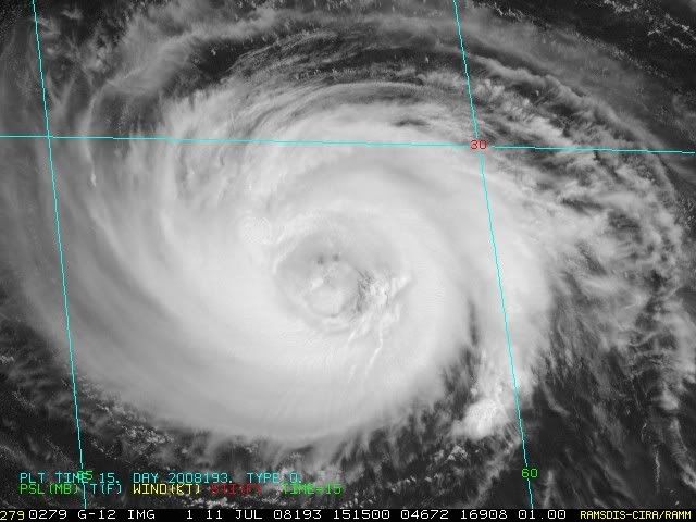
One thing I'd like to point out on the image blow is the tilt of the eyewall remains. Note that you can identify what looks like 3 concentric rings - one farthest southwest at the surface, one in the mid levels, and one higher up. Picture a cylinder that's pointed up and away from the camera. Remember that the "camera" (the satellite) is located over the Equator to the south and west of Bertha. So when you look at the eye from that angle, the top of the eye is farther away than the bottom (near the surface). That's why the surface center is located in the southwest part of the eye.
HURAKAN wrote:
Wow!!

0 likes

-
JonathanBelles
- Professional-Met
- Posts: 11430
- Age: 35
- Joined: Sat Dec 24, 2005 9:00 pm
- Location: School: Florida State University (Tallahassee, FL) Home: St. Petersburg, Florida
- Contact:
Re: Re:
wxman57 wrote:One thing I'd like to point out on the image blow is the tilt of the eyewall remains. Note that you can identify what looks like 3 concentric rings - one farthest southwest at the surface, one in the mid levels, and one higher up. Picture a cylinder that's pointed up and away from the camera. Remember that the "camera" (the satellite) is located over the Equator to the south and west of Bertha. So when you look at the eye from that angle, the top of the eye is farther away than the bottom (near the surface). That's why the surface center is located in the southwest part of the eye.HURAKAN wrote:img omitted
I knew where the satellite was, but never looked at the eye in that way. pretty cool!
0 likes
-
Weatherfreak14

- Category 5

- Posts: 1381
- Joined: Sat Sep 24, 2005 3:40 pm
- Location: Beaufort, SC
- Contact:
Re: Hurricane Bertha in Western Atlantic
Last frame shows a little wooble to the west and it looks really bad for bermuda if this thing does not take off to the north soon.
0 likes
-
CrazyC83
- Professional-Met
- Posts: 34315
- Joined: Tue Mar 07, 2006 11:57 pm
- Location: Deep South, for the first time!
Re:
HURAKAN wrote:What kind of gave me a shock is to realize that in five days Bertha would have just crossed 35°N. I know we want to track cyclones, but to track the same one for too long becomes kind of boring!! WE WANT CRISTÓBAL!!!
It could easily be a month before we get Cristobal.
0 likes
-
Matt-hurricanewatcher
Re:
KWT wrote:Yeah thats the thing with Bertha its had so many various traits of different systems over the last 5 days and plus it has been setting history, its far more exciting then say the 06 cape verde systems. Wxman57...that sounds pretty bullish for you!
Not as good as the 1999, 2000, 2003, 2004 cape verdes. But better then 2006,2007. In better then 2005.
0 likes
Who is online
Users browsing this forum: No registered users and 29 guests