TC Bertha
Moderator: S2k Moderators


-
JonathanBelles
- Professional-Met

- Posts: 11430
- Age: 35
- Joined: Sat Dec 24, 2005 9:00 pm
- Location: School: Florida State University (Tallahassee, FL) Home: St. Petersburg, Florida
- Contact:
Re: Hurricane Bertha in Western Atlantic
These ones are better.
BTW this is my last post for likely a few days.
0 likes


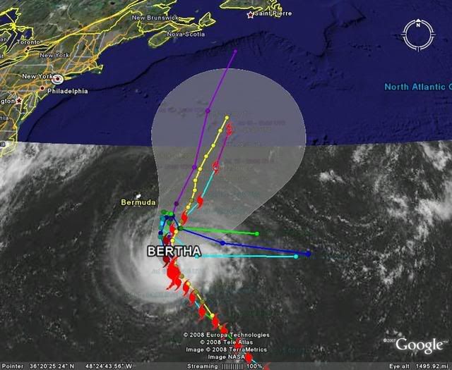
I couldn't imagine Bertha doing a loop and lasting another week and yet even if it doesn't do a loop it looks quite possible Bertha will be with us at least to the start of next week and by that time we may have a new freind to watch out for further south, the trough doesn't seem to have the power to lift Bertha out once and for all.
0 likes
-
wxman57

- Moderator-Pro Met

- Posts: 23099
- Age: 68
- Joined: Sat Jun 21, 2003 8:06 pm
- Location: Houston, TX (southwest)
Re: Hurricane Bertha in Western Atlantic
99kts FL wind in SE quadrant on outbound leg. That's stronger than 80 kts at the surface.
0 likes

Re:
HURAKAN wrote:What kind of gave me a shock is to realize that in five days Bertha would have just crossed 35°N. I know we want to track cyclones, but to track the same one for too long becomes kind of boring!! WE WANT CRISTÓBAL!!!
Remind me to remind you that you wrote that!
0 likes
-
Derek Ortt
Re: Hurricane Bertha in Western Atlantic
wxman57 wrote:99kts FL wind in SE quadrant on outbound leg. That's stronger than 80 kts at the surface.
and 121KT is too high for 90 at the surface
in all seriousness... I think we have a structure similar to Isabel when it struck Hat... where the surface winds are only about 70-75% of the flight level winds
0 likes
Re:
KWT wrote:I remember someone saying earlier on this was like Isabel, I wasn't really tracking hurricanes at that time so does anyone have an image of Isabel at the time Derek is talking about?
As cat 5

Near landfall

0 likes
-
brunota2003

- S2K Supporter

- Posts: 9476
- Age: 35
- Joined: Sat Jul 30, 2005 9:56 pm
- Location: Stanton, KY...formerly Havelock, NC
- Contact:
Re: Hurricane Bertha in Western Atlantic
Derek Ortt wrote:wxman57 wrote:99kts FL wind in SE quadrant on outbound leg. That's stronger than 80 kts at the surface.
and 121KT is too high for 90 at the surface
in all seriousness... I think we have a structure similar to Isabel when it struck Hat... where the surface winds are only about 70-75% of the flight level winds
Indeed. A large eye that has part of an inner eyewall remaining, along with shallow convection that is having trouble transporting the strongest winds aloft down to the surface.
0 likes

Hmmm yeah I can see the similarties now I've seen Isabel at landfall, big eye which is clouded to some degree with a messy eyewall, esp in the northern segment of the hurricane.
That inner eyewall on the southern side still hasn't gone, I've got a feeling thats going to be there till the system loses its eye totally whenever that will be.
That inner eyewall on the southern side still hasn't gone, I've got a feeling thats going to be there till the system loses its eye totally whenever that will be.
0 likes
-
cycloneye

- Admin

- Posts: 148577
- Age: 69
- Joined: Thu Oct 10, 2002 10:54 am
- Location: San Juan, Puerto Rico
Re: Hurricane Bertha in Western Atlantic
The Latest from ATCF:75 kts,977 mbs.Of course this can change as recon releases the data.
AL, 02, 2008071118, , BEST, 0, 287N, 621W, 75, 977, HU, 64, NEQ, 25, 15, 15, 25, 1014, 200, 15, 0, 0,
AL, 02, 2008071118, , BEST, 0, 287N, 621W, 75, 977, HU, 64, NEQ, 25, 15, 15, 25, 1014, 200, 15, 0, 0,
0 likes
Who is online
Users browsing this forum: No registered users and 44 guests