TC Bertha

Moderator: S2k Moderators

Message
Author
RL3AO
Moderator-Pro Met
Moderator-Pro Met
Posts: 16308
Joined: Thu Jun 14, 2007 10:03 pm
Location: NC

#3701 Postby RL3AO » Fri Jul 11, 2008 1:56 pm

Extrap pressures of 975.
0 likes   

User avatar
KWT
Category 5
Category 5
Posts: 31415
Joined: Tue Aug 17, 2004 11:02 am
Location: UK!!!

#3702 Postby KWT » Fri Jul 11, 2008 2:00 pm

Yeah though I think the vortex will come through about 1mb above that, that seems to be what normally happens. Now just got to wait for the pass through the SW eyewall but if we can't find any higher winds then I agree with Derek 75kts sounds about right, maybe a little higher at 80kts IMO?
0 likes   

User avatar
gatorcane
S2K Supporter
S2K Supporter
Posts: 23691
Age: 47
Joined: Sun Mar 13, 2005 3:54 pm
Location: Boca Raton, FL

Re: Hurricane Bertha in Western Atlantic

#3703 Postby gatorcane » Fri Jul 11, 2008 2:01 pm

is the GFS now showing a "loop" scenario?
Last edited by gatorcane on Fri Jul 11, 2008 2:05 pm, edited 1 time in total.
0 likes   

User avatar
HURAKAN
Professional-Met
Professional-Met
Posts: 46086
Age: 38
Joined: Thu May 20, 2004 4:34 pm
Location: Key West, FL
Contact:

Re: Hurricane Bertha in Western Atlantic

#3704 Postby HURAKAN » Fri Jul 11, 2008 2:03 pm

WAIT:

DID WE ALREADY ECLIPSED FRANCES' RECORD?
0 likes   

RL3AO
Moderator-Pro Met
Moderator-Pro Met
Posts: 16308
Joined: Thu Jun 14, 2007 10:03 pm
Location: NC

#3705 Postby RL3AO » Fri Jul 11, 2008 2:04 pm

Image
0 likes   

RL3AO
Moderator-Pro Met
Moderator-Pro Met
Posts: 16308
Joined: Thu Jun 14, 2007 10:03 pm
Location: NC

Re: Hurricane Bertha in Western Atlantic

#3706 Postby RL3AO » Fri Jul 11, 2008 2:04 pm

HURAKAN wrote:WAIT:

DID WE ALREADY ECLIPSED FRANCES' RECORD?


Wasn't frances 187?
0 likes   

User avatar
HURAKAN
Professional-Met
Professional-Met
Posts: 46086
Age: 38
Joined: Thu May 20, 2004 4:34 pm
Location: Key West, FL
Contact:

Re: Hurricane Bertha in Western Atlantic

#3707 Postby HURAKAN » Fri Jul 11, 2008 2:06 pm

RL3AO wrote:
HURAKAN wrote:WAIT:

DID WE ALREADY ECLIPSED FRANCES' RECORD?


Wasn't frances 187?


Luis says so in page 177. Sorry, I thought it was 184. Still, not much to go.
0 likes   

User avatar
storms in NC
S2K Supporter
S2K Supporter
Posts: 2338
Joined: Thu Jul 28, 2005 2:58 pm
Location: Wallace,NC 40 miles NE of Wilm
Contact:

#3708 Postby storms in NC » Fri Jul 11, 2008 2:06 pm

Remember Kyle- the storm stayed out over open water for several weeks, and
appeared to be headed for the North Atlantic at one point. It then
recurved, moved back to the SOUTH, and eventually affected the US coast.
0 likes   

User avatar
KWT
Category 5
Category 5
Posts: 31415
Joined: Tue Aug 17, 2004 11:02 am
Location: UK!!!

#3709 Postby KWT » Fri Jul 11, 2008 2:11 pm

What a messy eye still, its like someone has gauged out a big lump of the system but has left loads over as a result!

We are going to be Frances into 4th place, if Bertha lasts long enough we even have a shot at 2nd but 1st is way out of the question!
0 likes   

ggg
Tropical Wave
Tropical Wave
Posts: 9
Joined: Mon Jul 07, 2008 12:28 pm

Re:

#3710 Postby ggg » Fri Jul 11, 2008 2:32 pm

KWT wrote:The 99kts was only a 10 seocnd reading mind you wxman57 if that makes any difference and the 30 second reading was only 92kts, maybe thats why?

Or maybe they are just using a lower reduction value?
The NHC uses the 10 second wind reading for intensification purposes; not the 30 second.
0 likes   

ggg
Tropical Wave
Tropical Wave
Posts: 9
Joined: Mon Jul 07, 2008 12:28 pm

#3711 Postby ggg » Fri Jul 11, 2008 2:34 pm

Expect a major track shift to the west from the NHC by 10pm advisory if the 18z GFDL shows what it did on the 12z run.
0 likes   

Aric Dunn
Category 5
Category 5
Posts: 21238
Age: 42
Joined: Sun Sep 19, 2004 9:58 pm
Location: Ready for the Chase.
Contact:

#3712 Postby Aric Dunn » Fri Jul 11, 2008 2:43 pm

this is the coolest looking hurricane i think i have ever seen ..and its about to have one of the largest eyes i have ever seen. ..as well the best outflow in while
0 likes   

User avatar
HURAKAN
Professional-Met
Professional-Met
Posts: 46086
Age: 38
Joined: Thu May 20, 2004 4:34 pm
Location: Key West, FL
Contact:

#3713 Postby HURAKAN » Fri Jul 11, 2008 2:45 pm

Image

Nice outflow but the eye looks like the San Francisco Bay!!!
0 likes   

User avatar
KWT
Category 5
Category 5
Posts: 31415
Joined: Tue Aug 17, 2004 11:02 am
Location: UK!!!

#3714 Postby KWT » Fri Jul 11, 2008 2:52 pm

Its certainly a strange looking system, its got the biggest eye IMO since Wilma went zooming of to the NE in 2005 over the Atlantic. Also outflow is pretty impressive as well. To think this system once had a tiny little eye and was compact, now its eye is just huge!
0 likes   

User avatar
storms in NC
S2K Supporter
S2K Supporter
Posts: 2338
Joined: Thu Jul 28, 2005 2:58 pm
Location: Wallace,NC 40 miles NE of Wilm
Contact:

Re:

#3715 Postby storms in NC » Fri Jul 11, 2008 2:56 pm

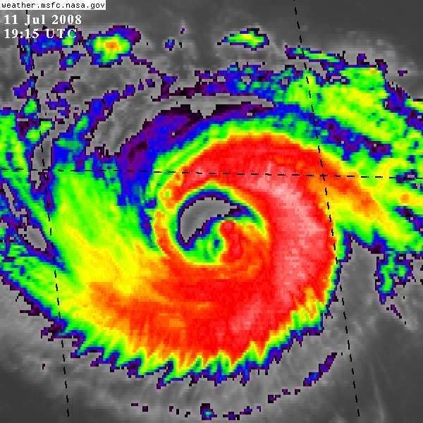
KWT wrote:Its certainly a strange looking system, its got the biggest eye IMO since Wilma went zooming of to the NE in 2005 over the Atlantic. Also outflow is pretty impressive as well. To think this system once had a tiny little eye and was compact, now its eye is just huge!


so I can see you better my dear.


Big eye going to build a big storm?
0 likes   

User avatar
cheezyWXguy
Category 5
Category 5
Posts: 6108
Joined: Mon Feb 13, 2006 12:29 am
Location: Dallas, TX

Re: Hurricane Bertha in Western Atlantic

#3716 Postby cheezyWXguy » Fri Jul 11, 2008 3:03 pm

wow bertha appears to be strengthening right now, seing as some of the darkest convection shes had since being a major is now wrapping around the entire system. The eye wall is somewhat loose now, but compared to early this morning, its like the difference between night and day.
0 likes   

RL3AO
Moderator-Pro Met
Moderator-Pro Met
Posts: 16308
Joined: Thu Jun 14, 2007 10:03 pm
Location: NC

#3717 Postby RL3AO » Fri Jul 11, 2008 3:07 pm

Image
0 likes   

User avatar
HURAKAN
Professional-Met
Professional-Met
Posts: 46086
Age: 38
Joined: Thu May 20, 2004 4:34 pm
Location: Key West, FL
Contact:

#3718 Postby HURAKAN » Fri Jul 11, 2008 3:09 pm

Image

Image

Strong convection developing over the eastern hemisphere of the storm.
0 likes   

User avatar
WmE
Category 2
Category 2
Posts: 696
Age: 36
Joined: Sat Jun 17, 2006 11:23 am
Location: Vienna, Austria

#3719 Postby WmE » Fri Jul 11, 2008 3:10 pm

Yep seems to be strenghtening now.
0 likes   

User avatar
PTrackerLA
Category 5
Category 5
Posts: 5277
Age: 41
Joined: Thu Oct 10, 2002 8:40 pm
Location: Lafayette, LA

Re: Hurricane Bertha in Western Atlantic

#3720 Postby PTrackerLA » Fri Jul 11, 2008 3:13 pm

I take back my "next" comment regarding Bertha from early this week. Bertha has been one of the most interesting storms to watch in the past few years and now it looks like she'll be around for quite a bit longer!
0 likes   


Return to “2008”

Who is online

Users browsing this forum: No registered users and 8 guests