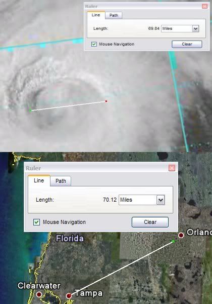
The following post is NOT an official prognosis.Bertha is still situated over +28 C SSTs (with small areas near ~29 C) and sufficient oceanic heat content, which is contributing to a more unstable boundary layer and rapid ascent of parcels, especially along the eastern semicircle. The signs are evident: note the initiation and development of additional thunderstorms east of the center. Since a new larger eye has developed (as I expected) overnight, there is no contrast between the sinking subsidence in the remnant inner eye and the subsidence that is contributing to the formation of the current larger eye. The small and ephermal inner eyewall is currently dissipating, while the large outer eyewall is starting to gradually contract, so I anticipate a brief period of re-intensification as the TC moves slowly and remains over substantial SSTs/OHC. Consequently, I believe Bertha may approach Category 2 intensity for a period as it slows and briefly stalls near Bermuda. Bertha is clearly exhibiting a very large eye near ~69 mi in diameter; when the structure of the TC is considered, it is probable that Bertha may eventually evolve to an annular hurricane, especially as the slow forward movement contributes to upwelling and the TC eventually moves over lower OHC/SSTs beyond the next ~24-36 hours. Since Bertha will eventually encounter decreasing OHC and SSTs, the strongest winds (again) will likely not mix to the surface; in light of all available data, I do not believe Bertha will exceed strong Category 1 intensity (~80 kt). However, residents in Bermuda (like all other regions) should be prepared for stronger winds and any category on the Saffir-Simpson Hurricane Scale; with the trends in the track, it is becoming increasingly plausible that the island will experience 1-min winds of at least TS intensity, and the probabilities of brief sustained hurricane force winds (or at least gusts) are increasing. This will be explained in the next paragraph.
Although the short term movement is nearly due north, the long term movement continues to indicate a NW track.
A shortwave trough to the west of Bertha will likely remain largely in place, leaving the TC under weak upper level steering currents (
per 400-850 mb streamline analysis) within the short to medium term. The problems resulting from this movement are manifold. The larger wind radii (which I mentioned yesterday) will likely contribute to greater chances of sustained TS force winds (<34 kt) on Bermuda, especially when it is corrobated with Bertha's current close proximity to Bermuda and its long term NW movement. This also increases the probabilities of hurricane force gusts, and there is a chance that sustained winds of hurricane intensity (<64 kt) could briefly occur over isolated portions of Bermuda and the immediate offshore waters. However, it is more likely that the vast majority of the island will experience 1-min winds of TS force with hurricane force gusts. The long duration of Bertha's impact (because of its slow drift) over the next few days will likely result in an enhanced threat for large waves and erosion along the island, especially on the northern, eastern, and southern portions which are exposed.
Bermudians should be prepared (in terms of supplies and protection of vulnerable oceanfront/beach structures) for a lengthy erosion, wave, and wind threat. Erosion and large waves will be a much more significant threat than the wind, since structures are very staunch and well constructed to withstand winds, though winds will still cause damages to trees and vegetation. Overall, Bermuda residents should be ready for the extended erosion/wave threat over the next few days. A loop is becoming more plausible, which could prolong Bertha's presence near Bermuda over the extended period (next several days), though the wind/wave/erosion threat should subside beyond Sunday and Monday as Bertha moves further from the island.
http://www.ssd.noaa.gov/goes/flt/t1/loop-avn.htmlEdit: I believe the possible stall will be very brief and temporary.