
SO THE CHANGE FOR REINTENSIFICATION EXISTS
Spelling error. The question is, will this be corrected?
TC Bertha
Moderator: S2k Moderators

Re:
MiamiensisWx wrote:...LARGE EYE OF BERTHA LEISURELY MOVING NORTH-NORTHWESTWARD...
Lixion Avila is probably making a vain attempt to reduce his stress. Undoubtedly, Bertha has been perplexing even for the NHC's forecasting, including the forecasters involved.
I think the realization that they may be dealing with this storm and perhaps another storm or two developing in the Atlantic next week, is getting to him.
Let's not the forget the invests in the EPAC too.
0 likes
-
HurricaneHunter914
- Category 5

- Posts: 4439
- Age: 32
- Joined: Fri Mar 10, 2006 7:36 pm
- Location: College Station, TX

-
MiamiensisWx
Re:
HurricaneHunter914 wrote:It looks like Bertha has a protective barrier against shear.
PS-5 more posts till we break Frances' thread record.
There is no "protective barrier" for any TC against shear. There is simply little shear in the vicinity, and the divergence from the upper low to the west is providing ascent and enhancing outflow from thunderstorms on the western semicircle. Vertical wind shear is also marginal because of an upper level anticyclone at 200 mb (denoted by anticyclonic wind vectors) over the TC. Remember that shear can aid a TC in several situations as well.
WV (showing upper low SW of Bertha):
http://hadar.cira.colostate.edu/ramsdis/online/trop_ge_wv_ls_0.html
Current GFS chart at 200 mb (showing anticyclonic wind vectors over Bertha):
http://www.nco.ncep.noaa.gov/pmb/nwprod/analysis/carib/gfs/12/images/gfs_200_000l.gif
The broad wind fields at the mid and and upper levels are also creating conducive mid/upper level diffluence.
There is no mystical "protective barrier" against shear, and a TC does not fight it. There are only favorable and unfavorable conditions (synoptics, thermodynamics, etc.); they are the only factors that determine TC intensity trends. TCs do not have "hearts", "brains", or "courage" (to paraphrase the Wizard of Oz) to "fight" anything. It's a scientific fallacy, though it may be entertaining to contemplate.
However, if you're referring to the upper level anticyclone as a "protective barrier", you are slightly correct. However, there are more factors than the H2 upper level anticyclone at play.
Last edited by MiamiensisWx on Fri Jul 11, 2008 4:14 pm, edited 1 time in total.
0 likes

-
orion

- S2K Supporter

- Posts: 165
- Joined: Mon Aug 02, 2004 5:44 pm
- Location: Indian Harbour Beach, FL
- Contact:
Re: Hurricane Bertha in Western Atlantic
With the talk a couple pages back looking at some of the similarities between Bertha and Isabel, thought I would share this image...
[url]
http://orionweather.net/51678main_isabel_new_high.jpg[/url]

One of my favorite images of Isabel.
[url]
http://orionweather.net/51678main_isabel_new_high.jpg[/url]
One of my favorite images of Isabel.
0 likes
-
MiamiensisWx


So a near enough 70 mile wide, about as wide as Wilma's was when it zoomed out into the Atlantic in 2005.
Low shear still over the system so that doesn't seem to be a problem, indeed as miami said I think this could well evolve into an annular system as it continues to move towards the lower heat content region over the next 96hrs.
In terms of track I would like to see a reduction in foward speed soon if we are to observe the type of loops the GFS expects, personally I think the GFDL is probably the closest to the truth, small loop then off to the NNE slowly.
0 likes
-
cycloneye

- Admin

- Posts: 149305
- Age: 69
- Joined: Thu Oct 10, 2002 10:54 am
- Location: San Juan, Puerto Rico
Re: Hurricane Bertha in Western Atlantic
This thread acends to 5th place among the hurricane threads with the most pages as it passed Frances 187 pages.Next will be Noels thread that had 196 pages.
0 likes


-
srainhoutx

- S2K Supporter
- Posts: 6919
- Age: 68
- Joined: Sun Jan 14, 2007 11:34 am
- Location: Haywood County, NC
- Contact:
Re: Hurricane Bertha in Western Atlantic
One of my favorites of Isabel 2003...
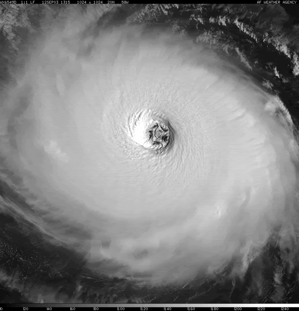
Now back to Bertha
Now back to Bertha
0 likes
-
cycloneye
- Admin
- Posts: 149305
- Age: 69
- Joined: Thu Oct 10, 2002 10:54 am
- Location: San Juan, Puerto Rico
Re: Hurricane Bertha in Western Atlantic
Top ten Tropical Storm and hurricane threads with most pages:
1-Dean=583
2-Ivan=352
3-Wilma=282
4-Chris=265
5-Noel=196
6-Bertha=?????
7-Frances=187
8-Ernesto=177
9-Ingrid=132
10-Charley=124
1-Dean=583
2-Ivan=352
3-Wilma=282
4-Chris=265
5-Noel=196
6-Bertha=?????
7-Frances=187
8-Ernesto=177
9-Ingrid=132
10-Charley=124
0 likes

Re:
KWT wrote:By the way cycloneye would it be possible to put the thread lengths up again so we can see just how we are going, Dean is IMO out of reach all the others may not be however. I'd imagine if we ever got a hugo/Andrew on this board a 1000 page thread would not be impossible...
1000 pages? I think now you're exaggerating a little.
0 likes
-
weatherguru18
Re: Hurricane Bertha in Western Atlantic
Rita only had 53 pages?!?!?!?!?!?!?!? It took dead aim at the 4th largest city in the country! I have failed you. I apologize...as should every other Houstonian.  I sure thought that people would be bouncing off the walls on that one. I'm even shocked at Katrina...only 111?? And here we are approaching 200 on a pissy storm like Bertha? Though I have to admit, it's been fun and eratic (forgive my spelling).
0 likes
not really WmE I mean a big cat-4/5 cape verde hurricane hitting the USA lasting 14-16 days could notch up that sort of amount I bet!
Look at Dean, 583 pages and it was never really a threat to the USA.
Anyway sorry Ive dragged this way off topic my bad!
I personally think we are going to have bertha for a little while yet and as it heads under that lower heat content I think we shall see those outer bands decay and this system finally become Annular, its got a large enough eye right now and probably is only failing on one of the charactistic now I suspect.
0 likes
-
Hurricanewatcher2007

- Category 2

- Posts: 578
- Joined: Sat Jul 05, 2008 8:10 pm
Re: Hurricane Bertha in Western Atlantic
well before it starts hitting cooler water it has a small pocket of 29C water to go through!
0 likes
Re: Hurricane Bertha in Western Atlantic
weatherguru18 wrote:Rita only had 53 pages?!?!?!?!?!?!?!? It took dead aim at the 4th largest city in the country! I have failed you. I apologize...as should every other Houstonian.
I'm guessing its because S2K got much busier after the 2005 season.
0 likes
Who is online
Users browsing this forum: No registered users and 34 guests