ATL: Tropical Depression Dolly
Moderator: S2k Moderators
-
brunota2003

- S2K Supporter

- Posts: 9476
- Age: 35
- Joined: Sat Jul 30, 2005 9:56 pm
- Location: Stanton, KY...formerly Havelock, NC
- Contact:
-
Blown Away

- S2K Supporter
- Posts: 10253
- Joined: Wed May 26, 2004 6:17 am
Re: ATL: INVEST 94L East of the Windward Islands
MiamiensisWx wrote:Speculation is driving me nuts...
It's far too early to prognosticate beyond the islands, in my view.
Seems very likely 94L will become a TD, it looks very healthy rate now and once we get tomorrow's visible, I bet we find a LLC and a TD. No matter how much reason you provide models tracking a system near the SE Bahamas is going to get people excited. Seems likely we will have Cristobal moving through the Hebert box into the NE Caribbean and generally towards SFL. Don't get to frustrated.
0 likes
-
MiamiensisWx
Re:
RL3AO wrote:The word/phrases: "Florida", "East Coast" and "Gulf of Mexico" have absolutely no need to be mentioned. Right now it is a tropical wave well to the east of the Windward Islands.
Exactly!!!
...and a TC like Andrew or 1926 is extremely rare. Do your research on south FL climo.
I WILL stop posting if the unabated speculation continues.
0 likes

Re: ATL: INVEST 94L East of the Windward Islands
Blown_away wrote:MiamiensisWx wrote:Speculation is driving me nuts...
It's far too early to prognosticate beyond the islands, in my view.
Seems very likely 94L will become a TD, it looks very healthy rate now and once we get tomorrow's visible, I bet we find a LLC and a TD. No matter how much reason you provide models tracking a system near the SE Bahamas is going to get people excited. Seems likely we will have Cristobal moving through the Hebert box into the NE Caribbean and generally towards SFL. Don't get to frustrated.
Unless the Bahamas have moved 800 miles east, its not near the SE Bahamas. Its north of Anguilla when the run ends.
0 likes
-
DESTRUCTION5

- Category 5

- Posts: 4430
- Age: 44
- Joined: Wed Sep 03, 2003 11:25 am
- Location: Stuart, FL
Re: Re:
MiamiensisWx wrote:RL3AO wrote:The word/phrases: "Florida", "East Coast" and "Gulf of Mexico" have absolutely no need to be mentioned. Right now it is a tropical wave well to the east of the Windward Islands.
Exactly!!!
...and a TC like Andrew or 1926 is extremely rare. Do your research on south FL climo.
I WILL stop posting if the unabated speculation continues.
Man i love your info but you have about as much patience as my 3.5 year old trying to tie his shoes..
0 likes
-
Blown Away
- S2K Supporter
- Posts: 10253
- Joined: Wed May 26, 2004 6:17 am
Re: Re:
weatherguru18 wrote:DESTRUCTION5 wrote:gatorcane wrote:GFDL is bringing into South Florida as a CAT 3?
NO
YES
http://moe.met.fsu.edu/cgi-bin/gfdltc2. ... =Animation
Technically ESE of FL, but still more than a 1000 miles ESE. The end run is still ENE of PR. I wouldn't call that run a Cat 3 into SFL, more like a Cat 3 1000 miles away that needs to be watched.
0 likes

-
HURAKAN

- Professional-Met

- Posts: 46084
- Age: 39
- Joined: Thu May 20, 2004 4:34 pm
- Location: Key West, FL
- Contact:
I see here a discussion that for now it doesn't makes sense. Because a system forms near where Andrew or the 1926 Hurricane formed doens't mean that it will have the same track. It's just illogical to talk about something that far out. There is no computer in this planet or person on Earth that can precisely predict that far out. Therefore, we must concentrate on what is happening now.
0 likes
-
MiamiensisWx
Re:
HURAKAN wrote:I see here a discussion that for now it doesn't makes sense. Because a system forms near where Andrew or the 1926 Hurricane formed doens't mean that it will have the same track. It's just illogical to talk about something that far out. There is no computer in this planet or person on Earth that can precisely predict that far out. Therefore, we must concentrate on what is happening now.
Thank you!!!
Thank you!!!
Thank you!!!
0 likes
-
GeneratorPower

- S2K Supporter
- Posts: 1648
- Age: 46
- Joined: Sun Dec 18, 2005 11:48 pm
- Location: Huntsville, AL
Whoa! That puppy really got it's act together while I was gone. That's got a shot of upgrade at 11pm given the way the NHC has been pulling the trigger this year.
http://www.ssd.noaa.gov/goes/flt/t2/loop-avn.html
http://www.ssd.noaa.gov/goes/flt/t2/loop-avn.html
0 likes
-
CourierPR

- Category 5
- Posts: 1336
- Age: 72
- Joined: Tue Aug 31, 2004 7:53 pm
- Location: Pompano Beach, Florida
Re: ATL: INVEST 94L East of the Windward Islands
Unabated speculation on this forum is like sex and violence on TV. If I don't like it, I can choose to "change the channel" but this forum is too valuable to let anything drive me away.
0 likes
-
Mecklenburg
-
MiamiensisWx
Re: ATL: INVEST 94L East of the Windward Islands
CourierPR wrote:Unabated speculation on this forum is like sex and violence on TV. If I don't like it, I can choose to "change the channel" but this forum is too valuable to let anything drive me away.
Most of the coversation during an impending landfall isn't "valuable."
The majority of the posts during the landfall of Katrina were nonsense.
Last edited by MiamiensisWx on Sun Jul 13, 2008 8:26 pm, edited 1 time in total.
0 likes
Re: ATL: INVEST 94L East of the Windward Islands
94L 14-day track
Personal Forecast Disclaimer:
The posts in this forum are NOT official forecast and should not be used as such. They are just the opinion of the poster and may or may not be backed by sound meteorological data. They are NOT endorsed by any professional institution or storm2k.org. For official information, please refer to the NHC and NWS products.
0 likes
-
brunota2003
- S2K Supporter
- Posts: 9476
- Age: 35
- Joined: Sat Jul 30, 2005 9:56 pm
- Location: Stanton, KY...formerly Havelock, NC
- Contact:
Re: ATL: INVEST 94L East of the Windward Islands
Mecklenburg wrote:is GFDL that reliable?
Yes and no. Right now, none of the models are really all that "reliable" because there is no defined LLC to pick up. All the models are doing is picking up on a point and going from there, whereas the true LLC could be (in some extreme cases) a hundred miles or more away.
0 likes
-
Aric Dunn
- Category 5
- Posts: 21238
- Age: 43
- Joined: Sun Sep 19, 2004 9:58 pm
- Location: Ready for the Chase.
- Contact:
Re: ATL: INVEST 94L East of the Windward Islands
RL3AO wrote:94L 14-day track
Personal Forecast Disclaimer:
The posts in this forum are NOT official forecast and should not be used as such. They are just the opinion of the poster and may or may not be backed by sound meteorological data. They are NOT endorsed by any professional institution or storm2k.org. For official information, please refer to the NHC and NWS products.
Thats AWESOME>>>>>
0 likes
-
weatherguru18
Re: ATL: INVEST 94L East of the Windward Islands
RL3AO wrote:94L 14-day track
Personal Forecast Disclaimer:
The posts in this forum are NOT official forecast and should not be used as such. They are just the opinion of the poster and may or may not be backed by sound meteorological data. They are NOT endorsed by any professional institution or storm2k.org. For official information, please refer to the NHC and NWS products.
LMAO...are you telling me the folks in Panama are safe?
0 likes
-
HURAKAN
- Professional-Met
- Posts: 46084
- Age: 39
- Joined: Thu May 20, 2004 4:34 pm
- Location: Key West, FL
- Contact:
Re: ATL: INVEST 94L East of the Windward Islands
Mecklenburg wrote:is GFDL that reliable?
No computer models is 100% reliable. Too many factors to consider and as you go into the future, a minor error at the beginning could mean a big error 5 days out. Now, it makes sense based on the current wind pattern.

0 likes

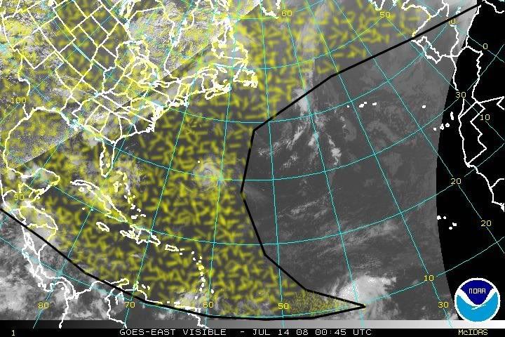
Re: ATL: INVEST 94L East of the Windward Islands
00:45 UTC imagery indicates a developing 94l that is or is just about to become a depression. Large envelope with this system with deeper convection spreading and developing closer to the LLC. Upgrade likely at 5am as organization continues overnight. I expect Cristobal by 11pm Monday night.
0 likes
Who is online
Users browsing this forum: No registered users and 41 guests