ATL: Tropical Depression Dolly

Moderator: S2k Moderators

Message
Author
User avatar
HURAKAN
Professional-Met
Professional-Met
Posts: 46086
Age: 38
Joined: Thu May 20, 2004 4:34 pm
Location: Key West, FL
Contact:

#501 Postby HURAKAN » Mon Jul 14, 2008 4:17 am

Image

Image
0 likes   

User avatar
HURAKAN
Professional-Met
Professional-Met
Posts: 46086
Age: 38
Joined: Thu May 20, 2004 4:34 pm
Location: Key West, FL
Contact:

#502 Postby HURAKAN » Mon Jul 14, 2008 4:19 am

Image
0 likes   

Matt-hurricanewatcher

Re: ATL: INVEST 94L East of the Windward Islands (TCFA)

#503 Postby Matt-hurricanewatcher » Mon Jul 14, 2008 4:22 am

Image

I think this is just as possible strength wise and track.
0 likes   

User avatar
KWT
Category 5
Category 5
Posts: 31415
Joined: Tue Aug 17, 2004 11:02 am
Location: UK!!!

#504 Postby KWT » Mon Jul 14, 2008 4:23 am

Looks good enough for an upgrade still IMO even though its not amazing to look at right now I've seen less get upgraded before!

Matt, thats similar to the ECM track I believe however I think the one difference is we have Bertha still about this time around whilst that set-up did not. Also according to the estimates this has been tracking WNW recently.
0 likes   

User avatar
HURAKAN
Professional-Met
Professional-Met
Posts: 46086
Age: 38
Joined: Thu May 20, 2004 4:34 pm
Location: Key West, FL
Contact:

#505 Postby HURAKAN » Mon Jul 14, 2008 4:28 am

I don't if anything has changed, but yesterday there wasn't any impediment for this system not to reach hurricane status before the islands. If this is the case, then a track further north can be expected.
0 likes   

User avatar
KWT
Category 5
Category 5
Posts: 31415
Joined: Tue Aug 17, 2004 11:02 am
Location: UK!!!

#506 Postby KWT » Mon Jul 14, 2008 4:30 am

The thing that I hope doesn't happen is a track over one island after another, not only would that kill this system but also have major impacts on the islands with regards to mudslides flash flooding etc, I remember what Jeanne did.
0 likes   

Matt-hurricanewatcher

Re: ATL: INVEST 94L East of the Windward Islands (TCFA)

#507 Postby Matt-hurricanewatcher » Mon Jul 14, 2008 4:34 am

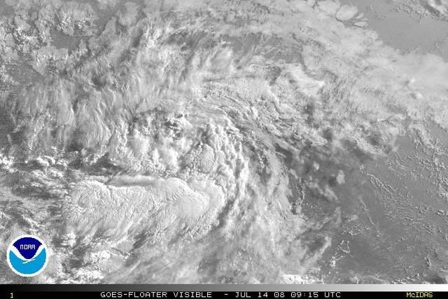
It looks alright, but I'm not sure the LLC is defined enough to be upgraded. Also the convection has decreased; I believe the nhc will wait intil convection reforms around 5pm for the upgrade.

I've got one of my hurricane season 2004 hurricane tapes in, when I used to have the weather channel. I used to tape the hurricanes and storms, and this one is about Charley, as of now it is just south of Cuba at 105 mph. Those where the days!

I got one of Frances to and Ivan. Keith 2000, Bertha 2002, Kyle.
Last edited by Matt-hurricanewatcher on Mon Jul 14, 2008 4:37 am, edited 1 time in total.
0 likes   

User avatar
KWT
Category 5
Category 5
Posts: 31415
Joined: Tue Aug 17, 2004 11:02 am
Location: UK!!!

#508 Postby KWT » Mon Jul 14, 2008 4:36 am

Maybe Matt though I still think its going to get upgraded today sometime. Convection isn't amazing but it wasn't all that amazing when Bertha was upgraded either so as long as there is deep convection nearby and a closed center I think it deserves an upgrade.
0 likes   

tropicsPR
Tropical Depression
Tropical Depression
Posts: 79
Joined: Fri Aug 15, 2003 9:52 pm
Location: Puerto Rico

#509 Postby tropicsPR » Mon Jul 14, 2008 4:40 am

Convection is increasing toward the center of circulation:
Image
0 likes   

User avatar
KWT
Category 5
Category 5
Posts: 31415
Joined: Tue Aug 17, 2004 11:02 am
Location: UK!!!

#510 Postby KWT » Mon Jul 14, 2008 4:46 am

Yep convection is a little scattered out still but its increasing again and it still seems to be close to being a tropical depression.
0 likes   

User avatar
HURAKAN
Professional-Met
Professional-Met
Posts: 46086
Age: 38
Joined: Thu May 20, 2004 4:34 pm
Location: Key West, FL
Contact:

#511 Postby HURAKAN » Mon Jul 14, 2008 5:02 am

Image
0 likes   

User avatar
KWT
Category 5
Category 5
Posts: 31415
Joined: Tue Aug 17, 2004 11:02 am
Location: UK!!!

#512 Postby KWT » Mon Jul 14, 2008 5:04 am

I'm guessing that deep convection on the southern side is a part of the ITCZ?
Doesn't look all that bad but I think the next 6-12hrs are going to determine if its a TD today or not.
0 likes   

User avatar
HURAKAN
Professional-Met
Professional-Met
Posts: 46086
Age: 38
Joined: Thu May 20, 2004 4:34 pm
Location: Key West, FL
Contact:

#513 Postby HURAKAN » Mon Jul 14, 2008 5:07 am

Image

Image
0 likes   

User avatar
AJC3
Admin
Admin
Posts: 3999
Age: 61
Joined: Tue Aug 31, 2004 7:04 pm
Location: Ballston Spa, New York
Contact:

Re: ATL: INVEST 94L East of the Windward Islands (TCFA)

#514 Postby AJC3 » Mon Jul 14, 2008 5:09 am

Latest QS pass is less than impressive...


Image
0 likes   

User avatar
Chacor
Category 5
Category 5
Posts: 10229
Joined: Mon Oct 02, 2006 10:43 pm
Location: Singapore

#515 Postby Chacor » Mon Jul 14, 2008 5:09 am

Still having trouble from getting out of the ITCZ, it looks like. By the way, in reference to some posts from earlier on in the thread, a number of EPac and CPac cyclones have been upgraded to depressions while still embedded within the ITCZ.
0 likes   

User avatar
KWT
Category 5
Category 5
Posts: 31415
Joined: Tue Aug 17, 2004 11:02 am
Location: UK!!!

#516 Postby KWT » Mon Jul 14, 2008 5:13 am

There is some turning down near 10N on that pass though whether its closed off I really can't say to be honest, it may not be enough to justify this being upgraded however.
0 likes   

User avatar
Thunder44
Category 5
Category 5
Posts: 5922
Age: 44
Joined: Mon Jun 09, 2003 7:53 pm
Location: New York City

Re: ATL: INVEST 94L East of the Windward Islands (TCFA)

#517 Postby Thunder44 » Mon Jul 14, 2008 5:15 am

Going by the latest QS, it looks like the area of low pressure is still very elongated. We probably won't see an upgrade at 11am, unless visible imagery shows something different by then.
0 likes   

bob rulz
Category 5
Category 5
Posts: 1704
Age: 35
Joined: Sat Jan 28, 2006 7:30 pm
Location: Salt Lake City, Utah

#518 Postby bob rulz » Mon Jul 14, 2008 5:16 am

There's still quite a while until the next advisory.

A lot can happen in 5 hours.
0 likes   

User avatar
KWT
Category 5
Category 5
Posts: 31415
Joined: Tue Aug 17, 2004 11:02 am
Location: UK!!!

#519 Postby KWT » Mon Jul 14, 2008 5:17 am

Agreed any LLC is pretty elongated W-E it appears right now, not really enough to justify a depression just yet though it does seem to be getting there steadily.
0 likes   

User avatar
Nimbus
Category 5
Category 5
Posts: 5300
Joined: Mon Jul 19, 2004 10:54 am

Re: ATL: INVEST 94L East of the Windward Islands (TCFA)

#520 Postby Nimbus » Mon Jul 14, 2008 5:51 am

All I see is storm relative turning centered down near 10N but I only looked at the wider central atlantic view.
Weak and west sounds right short term. Most of the models this orning have it going into the Caribbean,
but we don't have a clear LLC to initialize with yet.

Bertha is starting to move out so the NHC will be busy with storm advisories. Often a recurving storm like Bertha leaves a weakness for the next storm to follow, but Bertha has been drifting a long time in the same place. 94 L looks too far south to have any interaction with Bertha. Bertha would really have to loop back around deep to the south.
0 likes   


Return to “2008”

Who is online

Users browsing this forum: No registered users and 4 guests