New Africa Wave
Moderator: S2k Moderators
Forum rules

The posts in this forum are NOT official forecasts and should not be used as such. They are just the opinion of the poster and may or may not be backed by sound meteorological data. They are NOT endorsed by any professional institution or STORM2K. For official information, please refer to products from the National Hurricane Center and National Weather Service.
-
alienstorm

- Category 1

- Posts: 496
- Joined: Tue Jul 31, 2007 1:29 pm
- Location: Miami Fla western suburb
New Africa Wave
A new and rather impressive wave came off Africa today, I have been tracking this one for the past few days over the contientent. We will need to wait and see how it develops but the way thing have been so far this year I would give it a 50/50 chance for development by the weekend.
0 likes
-
Gustywind

- Category 5

- Posts: 12334
- Joined: Mon Sep 03, 2007 7:29 am
- Location: Baie-Mahault, GUADELOUPE
Re: New Africa Wave
alienstorm wrote:A new and rather impressive wave came off Africa today, I have been tracking this one for the past few days over the contientent. We will need to wait and see how it develops but the way thing have been so far this year I would give it a 50/50 chance for development by the weekend.
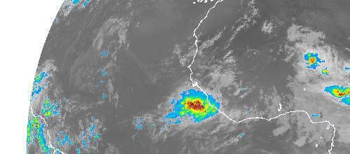
ok tkanks any sat pic please????
0 likes


-
Gustywind
- Category 5
- Posts: 12334
- Joined: Mon Sep 03, 2007 7:29 am
- Location: Baie-Mahault, GUADELOUPE
Re:
O Town wrote:Was just about to post those HURAKAN
Nice looking ball of convection but it seems a little too far south.
And what's the matter? Explain your idea? Do you mean that it won't developp or not?
0 likes


-
Windtalker1

- S2K Supporter

- Posts: 523
- Age: 37
- Joined: Sun Jul 31, 2005 11:00 am
- Location: Mesa, Arizona
Re: New Africa Wave
I'd also watch that little swirl in front of that one around 14/38. Me thinks it has a chance to start impressing us also.
0 likes
-
HurricaneHunter914
- Category 5
- Posts: 4439
- Age: 32
- Joined: Fri Mar 10, 2006 7:36 pm
- Location: College Station, TX
-
jhamps10
Re:
HurricaneHunter914 wrote:Big scary blob of convection with favorable conditions ahead looks scary.
But like all african waves, the convection will soon wane. Still, really impressive for July. August and September are gonna be scary.
but still it's large size of convection will certainly help it out in possible development I would think. I say a 55/45 shot for development.
0 likes
-
Just Joshing You

- Category 2

- Posts: 512
- Joined: Sat Nov 03, 2007 10:29 am
- Location: Nova Scotia
Re: New Africa Wave
This does look nice, but it won't start anything major until it gets past 10 degrees.
0 likes

-
Gustywind
- Category 5
- Posts: 12334
- Joined: Mon Sep 03, 2007 7:29 am
- Location: Baie-Mahault, GUADELOUPE
Somewhat active in the tropics
Wayne Verno, Lead Meteorologist, The Weather Channel
5:09 a.m. ET 7/17/2008
http://www.weather.com/newscenter/tropical/
Another low pressure area, currently void of any organized thunderstorms, was located west-southwest of the Cape Verde Islands, moving west. This area will continue to be monitored over the next few days; right now, there are no signs of any organization.
0 likes
-
Blown Away

- S2K Supporter
- Posts: 10253
- Joined: Wed May 26, 2004 6:17 am
Re: New Africa Wave
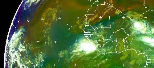
Almost a 600 mile wide blob of convection. That's a whopper! Do we have any models that develop this wave?
0 likes


Re: New Africa Wave
Looks interesting. We'll have to wait to see if it holds together, in next few days.
0 likes
-
DESTRUCTION5

- Category 5
- Posts: 4430
- Age: 44
- Joined: Wed Sep 03, 2003 11:25 am
- Location: Stuart, FL
-
DESTRUCTION5
- Category 5
- Posts: 4430
- Age: 44
- Joined: Wed Sep 03, 2003 11:25 am
- Location: Stuart, FL
Re:
Frank2 wrote:It's south of 10N and moving into the ITCZ, so...
Yea never fear Frank is here! LOL
0 likes
LOL
I purposely stayed away from here on Monday, when everyone was jumping up and down over 94L - glad I missed that hootenanny, especially since that's my new policy while at work - it'd be too much of a distraction to read all of those "Head for the hills - SHIPS shows 397 knots in 96 hours!" posts...
Or, something like that...
You must admit, the Atlantic basin went from busy to non-busy in 24 hours...
As Paula Dean (Food Network) would say, "Ya'll need to calm down some!"
Have a good day,
Frank
0 likes
Who is online
Users browsing this forum: TheAustinMan and 134 guests